AL, 96, 2021111000, , BEST, 0, 353N, 602W, 60, 982, EX, 50, NEQ, 0, 40, 60, 60, 1010, 240, 40, 0, 0, L, 0, , 0, 0, INVEST, D, 0, , 0, 0, 0, 0, genesis-num, 052, SPAWNINVEST, al772021 to al962021,
ATL: INVEST 96L - Discussion
Moderator: S2k Moderators
-
Nancy Smar

- Category 5

- Posts: 1081
- Age: 25
- Joined: Wed Aug 16, 2017 10:03 pm
ATL: INVEST 96L - Discussion
https://ftp.nhc.noaa.gov/atcf/btk/
Last edited by Nancy Smar on Tue Nov 09, 2021 8:17 pm, edited 1 time in total.
0 likes
-
Category5Kaiju

- Category 5
- Posts: 4334
- Joined: Thu Dec 24, 2020 12:45 pm
- Location: Seattle and Phoenix
Re: ATL: INVEST 96L - Discussion

When 96L had a 0/0 chance merely 12 hours ago
2 likes
Unless explicitly stated, all info in my posts is based on my own opinions and observations. Tropical storms and hurricanes can be extremely dangerous. Refer to an accredited weather research agency or meteorologist if you need to make serious decisions regarding an approaching storm.
-
Nancy Smar
- Category 5
- Posts: 1081
- Age: 25
- Joined: Wed Aug 16, 2017 10:03 pm
Re: ATL: INVEST 96L - Discussion
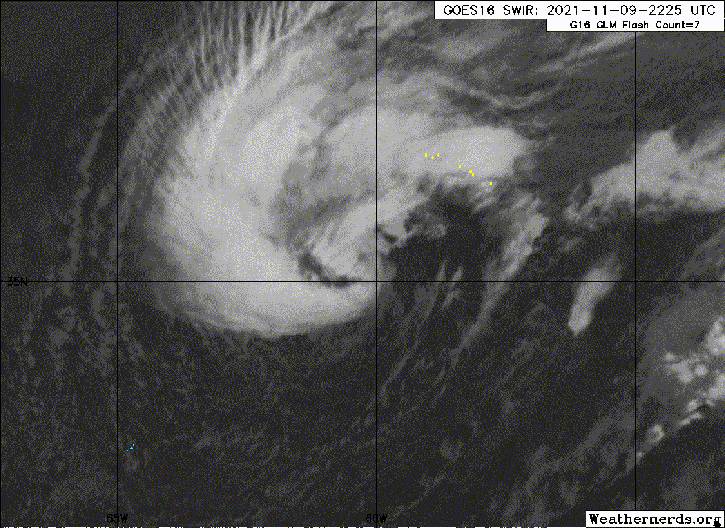
TXNT27 KNES 100038
TCSNTL
A. TROPICAL DISTURBANCE
B. 09/2330Z
C. 35.3N
D. 61.0W
E. THREE/GOES-E
F. T2.5/2.5
G. IR/EIR/SWIR
H. REMARKS...5.5/10 BANDING AROUND THE LLCC YIELDS A DT OF 2.5. NO
MET AND PT AS THE SYSTEM HAS TRANSITIONED FROM ST TO TROPICAL WITH NO
CLASSIFICATION 24 HOURS AGO. FT IS BASED ON DT.
I. ADDL POSITIONS
NIL
...TUGGLE
0 likes

Re: ATL: INVEST 96L - Discussion
Already 60kts  imagine if it transitions with 65kt winds, I don't think that has ever happened before...
Definitely brings up the age-old question over whether a storm's first advisory could be a hurricane!
Definitely brings up the age-old question over whether a storm's first advisory could be a hurricane!
0 likes
-
Sciencerocks
- Category 5
- Posts: 10186
- Age: 40
- Joined: Thu Jul 06, 2017 1:51 am
Re: ATL: INVEST 96L - Discussion
Already looks like a tropical storm!!! I'd go pretty high on this.
0 likes
Re: ATL: INVEST 96L - Discussion
zhukm29 wrote:Already 60kts
Definitely brings up the age-old question over whether a storm's first advisory could be a hurricane!
Did some digging and apparently Noel 2001's first advisory was a hurricane - however, it was a subtropical storm before becoming a hurricane, but subtropical storms were not named at the time.
0 likes

Re: ATL: INVEST 96L - Discussion
zhukm29 wrote:Already 60kts
Definitely brings up the age-old question over whether a storm's first advisory could be a hurricane!
I believe both Lili in 1984 and Noel in 2001 started out as hurricanes on their first operational advisory, but shows how uncommon it is.
1 likes
The above post is not official and should not be used as such. It is the opinion of the poster and may or may not be backed by sound meteorological data. It is not endorsed by any professional institution or storm2k.org. For official information, please refer to the NHC and NWS products.
-
Hurricanehink

- S2K Supporter

- Posts: 2045
- Joined: Sun Nov 16, 2003 2:05 pm
- Location: New Jersey
Re: ATL: INVEST 96L - Discussion
Up to 50%
Showers and thunderstorms associated with a strong non-tropical low centered about 350 miles northeast of Bermuda continue to show signs of organization. In addition, recent satellite wind data indicate that winds of near hurricane force are occurring south of the center. This system has not yet acquired enough tropical cyclone characteristics to be considered a subtropical storm. However, additional development is possible during the next day or two, and a subtropical storm could form during this time. After that time, the system is forecast to move over colder water and become absorbed by another non-tropical low. Additional information on this system can be found in High Seas forecasts issued by the National Weather Service.
* Formation chance through 48 hours...medium...50 percent.
* Formation chance through 5 days...medium...50 percent.
0 likes
-
InfernoFlameCat

- Category 5
- Posts: 2127
- Age: 22
- Joined: Mon Dec 14, 2020 10:52 am
- Location: Buford, GA
Re: ATL: INVEST 96L - Discussion
That was unexpected
0 likes
I am by no means a professional. DO NOT look at my forecasts for official information or make decisions based on what I post.
Goal: to become a registered expert over tropical and subtropical cyclones.
Goal: to become a registered expert over tropical and subtropical cyclones.

-
MarioProtVI
- Category 5
- Posts: 1034
- Age: 24
- Joined: Sun Sep 29, 2019 7:33 pm
- Location: New Jersey
Re: ATL: INVEST 96L - Discussion
zzh wrote:https://i.imgur.com/UMblMO0.jpg
Accounting for typical undersampling this is likely hurricane-force. Could see a Noel 2001-like transition.
I should also note that this further makes me believe Theta last year around this time did in fact achieve hurricane intensity since it was basically what 96L is now minus the fronts (sheared somewhat but had ASCAT of 60 kt). Appearance was identical too.
1 likes
Re: ATL: INVEST 96L - Discussion
What happens if a hurricane force non-tropical low develops subtropical characteristics? A subtropical hurricane?
0 likes
All posts by Dean_175 are NOT official forecasts and should not be used as such. They are just the opinion of the poster and may or may not be backed by sound meteorological data. They are NOT endorsed by any professional institution or storm2k.org. For official information, please refer to the NHC and NWS products.
-
wxman57

- Moderator-Pro Met

- Posts: 23175
- Age: 68
- Joined: Sat Jun 21, 2003 8:06 pm
- Location: Houston, TX (southwest)
Re: ATL: INVEST 96L - Discussion
Dean_175 wrote:What happens if a hurricane force non-tropical low develops subtropical characteristics? A subtropical hurricane?
The classification "subtropical" is intensity independent. It's still a subtropical storm whether winds are 35 kts or 135 kts. This storm system is still attached to a cold front. If it separates over the next 24 hours, then it will be STS Adria. Doesn't have much of a future.
1 likes

Re: ATL: INVEST 96L - Discussion
1 likes

-
KirbyDude25

- Tropical Storm

- Posts: 161
- Age: 21
- Joined: Mon Sep 20, 2021 8:03 am
- Location: Westfield, New Jersey
Re: ATL: INVEST 96L - Discussion
ChrisH-UK wrote:Latest ASCAT is showing winds in the 40-50 knt range.
https://i.imgur.com/Mppb9vs.png
A lot of the wind barbs look like they're 55-60 knots, with a few in the 65-70 kt range. Almost definitely a hurricane-force low.
1 likes
New Jersey, Rutgers '27
Irene 2011 | Sandy 2012 | Fay 2020 | Isaias 2020 | Ida 2021
Irene 2011 | Sandy 2012 | Fay 2020 | Isaias 2020 | Ida 2021

Re: ATL: INVEST 96L - Discussion
wxman57 wrote:Dean_175 wrote:What happens if a hurricane force non-tropical low develops subtropical characteristics? A subtropical hurricane?
The classification "subtropical" is intensity independent. It's still a subtropical storm whether winds are 35 kts or 135 kts. This storm system is still attached to a cold front. If it separates over the next 24 hours, then it will be STS Adria. Doesn't have much of a future.
Can a subtropical storm have 135 kts winds?
1 likes
TC naming lists: retirements and intensity
Most aggressive Advisory #1's in North Atlantic (cr. kevin for starting the list)
Most aggressive Advisory #1's in North Atlantic (cr. kevin for starting the list)
-
Hypercane_Kyle

- Category 5
- Posts: 3465
- Joined: Sat Mar 07, 2015 7:58 pm
- Location: Cape Canaveral, FL
Re: ATL: INVEST 96L - Discussion
Teban54 wrote:wxman57 wrote:Dean_175 wrote:What happens if a hurricane force non-tropical low develops subtropical characteristics? A subtropical hurricane?
The classification "subtropical" is intensity independent. It's still a subtropical storm whether winds are 35 kts or 135 kts. This storm system is still attached to a cold front. If it separates over the next 24 hours, then it will be STS Adria. Doesn't have much of a future.
Can a subtropical storm have 135 kts winds?
Something is whacky with the climate if we have a 135 knot subtropical storm.
1 likes
My posts are my own personal opinion, defer to the National Hurricane Center (NHC) and other NOAA products for decision making during hurricane season.
-
Hurricanehink
- S2K Supporter
- Posts: 2045
- Joined: Sun Nov 16, 2003 2:05 pm
- Location: New Jersey
Re: ATL: INVEST 96L - Discussion
https://cdn.star.nesdis.noaa.gov//GOES16/ABI/SECTOR/TAW/07/GOES16-TAW-07-900x540.gif
There does seem to be more convection near/over the center, versus eight hours ago.
There does seem to be more convection near/over the center, versus eight hours ago.
0 likes
-
Sciencerocks
- Category 5
- Posts: 10186
- Age: 40
- Joined: Thu Jul 06, 2017 1:51 am
Who is online
Users browsing this forum: No registered users and 33 guests