Anyone have a graphic?HockeyTx82 wrote:Iceresistance wrote:harp wrote:What frame is that? I don’t see it yet.
+288 Hours, towards Houston, TX
Lock it in.... it's got to be correct now
Sent from my SM-N975U using Tapatalk
Moderator: S2k Moderators
 The posts in this forum are NOT official forecast and should not be used as such. They are just the opinion of the poster and may or may not be backed by sound meteorological data. They are NOT endorsed by any professional institution or STORM2K.

Anyone have a graphic?HockeyTx82 wrote:Iceresistance wrote:harp wrote:What frame is that? I don’t see it yet.
+288 Hours, towards Houston, TX
Lock it in.... it's got to be correct now

kingwood_tx1999 wrote:Anyone have a graphic?HockeyTx82 wrote:Iceresistance wrote:
+288 Hours, towards Houston, TX
Lock it in.... it's got to be correct now
Sent from my SM-N975U using Tapatalk


kingwood_tx1999 wrote:Anyone have a graphic?HockeyTx82 wrote:Iceresistance wrote:
+288 Hours, towards Houston, TX
Lock it in.... it's got to be correct now
Sent from my SM-N975U using Tapatalk


NDG wrote:12z GEFS not in agreement with the 12z GFS.


Ntxw wrote:It's way out there still. Don't believe any verbatim GFS OP runs beyond 5 days.
What we can talk about is why are things going to change? The MJO of course. It has moved out of the maritime continent (Indonesia) that's been a staple since October. More importantly it is moving into the *opposite* composites than what has been AND of a good amplitude (strengthening) wave. That tells you a proverbial 'change' because that's the math. Just as important is sinking air, or subsidence will be behind it where the Nina standing wave was.
https://i.imgur.com/c259pki.png
The Nina, or what's left as it is a weakening event now, will attempt to slow it down as the wave moves east out of the WPAC into cooler waters of the Eastern tropical Pacific. For us that's not too important right now it just needs to get out of the bad phases which it has.
Being the Nina resisting I would expect changes to gradually be slow at first. Models tend to rush these changes.
1984-1985 is a decent analog right now with national weather along with MJO behavior/Arctic/and 2nd year Nina comparisons. You just have to account for the warmer period we are in compared to back then.
Golf7270 wrote:Do you think the standing wave has weakened enough or fallen apart to allow the mjo to propagate to get to the colder phases, because 4-6 in winter is very warm? I personally dont like those phases lol
Ntxw wrote:Golf7270 wrote:Do you think the standing wave has weakened enough or fallen apart to allow the mjo to propagate to get to the colder phases, because 4-6 in winter is very warm? I personally dont like those phases lol
I don't think anything happens in a vacuum. The idea of a 'snap' has merit. Everything works together. With the bad standing wave the convection in the WPAC never occurred and the water there continued to warm and eventually it was going to break out. Now that it has, it can generate the Okhotsk -> Aleutian low and attack the Arctic with heat flux. In winter there are two major drivers, the tropics and the cryosphere.
Maybe this MJO will do the work long term and we get an El Nino next year?
The good news is we are following closer to 1984-1985 than 2011-2012 regarding MJO. 2011-2012 it hovered the bad phases (4-6) December through Feb. When it finally moved to p7 in Feb 2012 it was too late and winter was essentially over by the time we could generate cold.
orangeblood wrote:Euro Ensembles continue to build Severe Cold in Western Canada right before Christmas...exactly what you want to start seeing in the long range for Arctic Outbreaks, we started a similar conversation at the end of January this year, a few weeks before the record February cold snap. Doesn't mean anything like that will come to fruition, however, this is the first few steps of many!! Also, happens to be the coldest air, relative to average, on the planet! This one has my attention....
https://images.weatherbell.com/model/ecmwf-ensemble-avg/namer/t850_anom_stream/1639051200/1640304000-hpZ2VSsv3g4.png
https://images.weatherbell.com/model/ecmwf-ensemble-avg/nhemi/t850_anom_stream/1639051200/1640304000-QLN15sHLjAY.png
Golf7270 wrote:orangeblood wrote:Euro Ensembles continue to build Severe Cold in Western Canada right before Christmas...exactly what you want to start seeing in the long range for Arctic Outbreaks, we started a similar conversation at the end of January this year, a few weeks before the record February cold snap. Doesn't mean anything like that will come to fruition, however, this is the first few steps of many!! Also, happens to be the coldest air, relative to average, on the planet! This one has my attention....
I think the key is to get the epo negative and take our chances. And the progression of the mjo.
orangeblood wrote:Golf7270 wrote:orangeblood wrote:Euro Ensembles continue to build Severe Cold in Western Canada right before Christmas...exactly what you want to start seeing in the long range for Arctic Outbreaks, we started a similar conversation at the end of January this year, a few weeks before the record February cold snap. Doesn't mean anything like that will come to fruition, however, this is the first few steps of many!! Also, happens to be the coldest air, relative to average, on the planet! This one has my attention....
I think the key is to get the epo negative and take our chances. And the progression of the mjo.
Every Tele Index Mean is now forecast to go negative around Dec. 20th +/-
lrak wrote:Rgv20 wrote:Forecast high of 87 today and 89 tomorrow...this is not right
I feel your pain Rgv20. My A/C has been on since last March. We need a big cold snap to cool the GOM.


orangeblood wrote:gboudx wrote:Iceresistance wrote:
I've alerted the School Officials about this, they will make an announcement about that Next Wednesday if this trend continues.
The thing with JB is he may be referring to his area specifically. Without more info, it's hard to know how wide he's casting that net.
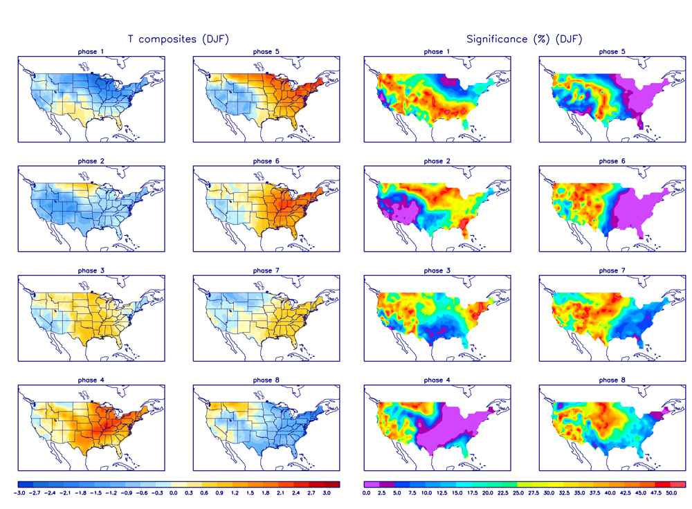
Here are great MJO temp composites of what you typically see during this time of year....as you can see 8-1-2 is prime for most widespread cold!
https://www.cpc.ncep.noaa.gov/products/precip/CWlink/MJO/Composites/Temperature/DJF/combined_image.png
Users browsing this forum: No registered users and 27 guests


