WPAC: RAI - Post-Tropical
Moderator: S2k Moderators
-
Sciencerocks
- Category 5

- Posts: 10186
- Age: 40
- Joined: Thu Jul 06, 2017 1:51 am
-
ElectricStorm

- Category 5
- Posts: 5147
- Age: 25
- Joined: Tue Aug 13, 2019 11:23 pm
- Location: Norman, OK
Re: WPAC: RAI - Typhoon
28W RAI 211218 0000 11.0N 115.9E WPAC 110 953
0 likes
B.S Meteorology, University of Oklahoma '25
Please refer to the NHC, NWS, or SPC for official information.
Please refer to the NHC, NWS, or SPC for official information.
-
doomhaMwx

- Category 5
- Posts: 2487
- Age: 27
- Joined: Tue Apr 18, 2017 4:01 am
- Location: Baguio/Benguet, Philippines
- Contact:
Re: WPAC: RAI - Typhoon
Data from some Chinese-built weather stations in the Spratly Islands would be really useful now.

1 likes
-
mrbagyo

- Category 5
- Posts: 3963
- Age: 33
- Joined: Thu Apr 12, 2012 9:18 am
- Location: 14.13N 120.98E
- Contact:
Re: WPAC: RAI - Typhoon

0 likes
The posts in this forum are NOT official forecast and should not be used as such. They are just the opinion of the poster and may or may not be backed by sound meteorological data. They are NOT endorsed by any professional institution or storm2k.org. For official information, please refer to RSMC, NHC and NWS products.
-
mrbagyo
- Category 5
- Posts: 3963
- Age: 33
- Joined: Thu Apr 12, 2012 9:18 am
- Location: 14.13N 120.98E
- Contact:
Re: WPAC: RAI - Typhoon
browning of vegetation at Santa Monica, Siargao Island

0 likes
The posts in this forum are NOT official forecast and should not be used as such. They are just the opinion of the poster and may or may not be backed by sound meteorological data. They are NOT endorsed by any professional institution or storm2k.org. For official information, please refer to RSMC, NHC and NWS products.
-
mrbagyo
- Category 5
- Posts: 3963
- Age: 33
- Joined: Thu Apr 12, 2012 9:18 am
- Location: 14.13N 120.98E
- Contact:
Re: WPAC: RAI - Typhoon
0 likes
The posts in this forum are NOT official forecast and should not be used as such. They are just the opinion of the poster and may or may not be backed by sound meteorological data. They are NOT endorsed by any professional institution or storm2k.org. For official information, please refer to RSMC, NHC and NWS products.
-
Sciencerocks
- Category 5
- Posts: 10186
- Age: 40
- Joined: Thu Jul 06, 2017 1:51 am
-
mrbagyo
- Category 5
- Posts: 3963
- Age: 33
- Joined: Thu Apr 12, 2012 9:18 am
- Location: 14.13N 120.98E
- Contact:
Re: WPAC: RAI - Typhoon
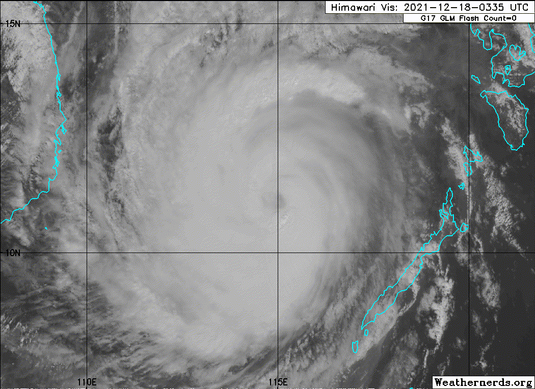
28W RAI 211218 0600 11.2N 114.8E WPAC 110 953
Rai now has a radial outflow.


Rai now has a radial outflow.
0 likes
The posts in this forum are NOT official forecast and should not be used as such. They are just the opinion of the poster and may or may not be backed by sound meteorological data. They are NOT endorsed by any professional institution or storm2k.org. For official information, please refer to RSMC, NHC and NWS products.

Re: WPAC: RAI - Typhoon
Interesting what would the 2nd peak be, eye temp for the very first time has went to + from ADT.

Would be amazed if it went to cat 5 again especially this sea has only 3 cat 5s on record or even beat the 1st peak.
2021DEC18 084000 6.7 933 132 6.7 7.0 7.3 1.3T/6hr OFF OFF OFF OFF 4.45 -79.07 EYE 17 IR 19.1 11.59 -113.98 ARCHER HIM-8 33.7
Would be amazed if it went to cat 5 again especially this sea has only 3 cat 5s on record or even beat the 1st peak.
0 likes
ヤンデレ女が寝取られるているのを見たい!!!
ECMWF ensemble NWPAC plots: https://ecmwfensnwpac.imgbb.com/
Multimodel NWPAC plots: https://multimodelnwpac.imgbb.com/
GFS Ensemble NWPAC plots (16 & 35 day forecast): https://gefsnwpac.imgbb.com/
Plots updated automatically
ECMWF ensemble NWPAC plots: https://ecmwfensnwpac.imgbb.com/
Multimodel NWPAC plots: https://multimodelnwpac.imgbb.com/
GFS Ensemble NWPAC plots (16 & 35 day forecast): https://gefsnwpac.imgbb.com/
Plots updated automatically
Re: WPAC: RAI - Typhoon
I still remember the shock when I saw Rammasun intensifying into a cat.5 (operationally 135kt) before making landfall over Hainan. I didn’t expect I’d see that again, not to mention in December.
0 likes
Personal Forecast Disclaimer:
The posts in this forum are NOT official forecast and should not be used as such. They are just the opinion of the poster and may or may not be backed by sound meteorological data. They are NOT endorsed by any professional institution or storm2k.org. For official information, please refer to RSMC and NWS products.
The posts in this forum are NOT official forecast and should not be used as such. They are just the opinion of the poster and may or may not be backed by sound meteorological data. They are NOT endorsed by any professional institution or storm2k.org. For official information, please refer to RSMC and NWS products.
-
mrbagyo
- Category 5
- Posts: 3963
- Age: 33
- Joined: Thu Apr 12, 2012 9:18 am
- Location: 14.13N 120.98E
- Contact:
Re: WPAC: RAI - Typhoon

0 likes
The posts in this forum are NOT official forecast and should not be used as such. They are just the opinion of the poster and may or may not be backed by sound meteorological data. They are NOT endorsed by any professional institution or storm2k.org. For official information, please refer to RSMC, NHC and NWS products.
Re: WPAC: RAI - Typhoon
2021DEC18 094000 7.0 925 140 7.0 7.3 7.6 1.3T/6hr OFF OFF OFF OFF 11.04 -80.91 EYE 14 IR 19.1 11.64 -113.92 ARCHER HIM-8 33.8
0 likes
ヤンデレ女が寝取られるているのを見たい!!!
ECMWF ensemble NWPAC plots: https://ecmwfensnwpac.imgbb.com/
Multimodel NWPAC plots: https://multimodelnwpac.imgbb.com/
GFS Ensemble NWPAC plots (16 & 35 day forecast): https://gefsnwpac.imgbb.com/
Plots updated automatically
ECMWF ensemble NWPAC plots: https://ecmwfensnwpac.imgbb.com/
Multimodel NWPAC plots: https://multimodelnwpac.imgbb.com/
GFS Ensemble NWPAC plots (16 & 35 day forecast): https://gefsnwpac.imgbb.com/
Plots updated automatically
-
mrbagyo
- Category 5
- Posts: 3963
- Age: 33
- Joined: Thu Apr 12, 2012 9:18 am
- Location: 14.13N 120.98E
- Contact:
Re: WPAC: RAI - Typhoon
eye temp is now at positive double digit
0 likes
The posts in this forum are NOT official forecast and should not be used as such. They are just the opinion of the poster and may or may not be backed by sound meteorological data. They are NOT endorsed by any professional institution or storm2k.org. For official information, please refer to RSMC, NHC and NWS products.
-
doomhaMwx
- Category 5
- Posts: 2487
- Age: 27
- Joined: Tue Apr 18, 2017 4:01 am
- Location: Baguio/Benguet, Philippines
- Contact:
Re: WPAC: RAI - Typhoon
mrbagyo wrote:Are there any other stations in the Spratlys other than Song Tu Tay (48892)?
https://i.imgur.com/HdP1nWL.png
http://www.xinhuanet.com/2018-10/31/c_1123641033.htm
Don't expect data to be publicly available, but China opened three meteorological stations there in 2018 (in Yongshu, Zhubi, and Meiji reefs). The article says there's even a weather radar there. Might be politically controversial but I think it's cool from a meteorological standpoint!

1 likes

Re: WPAC: RAI - Typhoon
Hey uh, what's everyone's intensity estimate for Rai's (first) peak and do you agree with the JTWC's/JMA's estimate?
0 likes
-
mrbagyo
- Category 5
- Posts: 3963
- Age: 33
- Joined: Thu Apr 12, 2012 9:18 am
- Location: 14.13N 120.98E
- Contact:
Re: WPAC: RAI - Typhoon
Imran_doomhaMwx wrote:mrbagyo wrote:Are there any other stations in the Spratlys other than Song Tu Tay (48892)?
https://i.imgur.com/HdP1nWL.png
http://www.xinhuanet.com/2018-10/31/c_1123641033.htm
Don't expect data to be publicly available, but China opened three meteorological stations there in 2018 (in Yongshu, Zhubi, and Meiji reefs). The article says there's even a weather radar there. Might be politically controversial but I think it's cool from a meteorological standpoint!
https://i.imgur.com/dyGznaD.png
There's absolutely a weather radar on those islands. I've seen a lot of radomes on those reclaimed island when I was browsing google earth pro.
0 likes
The posts in this forum are NOT official forecast and should not be used as such. They are just the opinion of the poster and may or may not be backed by sound meteorological data. They are NOT endorsed by any professional institution or storm2k.org. For official information, please refer to RSMC, NHC and NWS products.
-
dexterlabio
- Category 5
- Posts: 3508
- Joined: Sat Oct 24, 2009 11:50 pm
Re: WPAC: RAI - Typhoon
140kts/105kts from JTWC/JMA sound okay to me. It could've been higher if not for the unrelenting shear (which Rai had surprisingly overcome) and the EWRC prior to landfall. Still its intensity was enough to pack a punch. People in the Visayas and Mindanao are saying that Rai was more intense than Mike.
0 likes
Personal Forecast Disclaimer:
The posts in this forum are NOT official forecast and should not be used as such. They are just the opinion of the poster and may or may not be backed by sound meteorological data. They are NOT endorsed by any professional institution or storm2k.org. For official information, please refer to the NHC and NWS products.
The posts in this forum are NOT official forecast and should not be used as such. They are just the opinion of the poster and may or may not be backed by sound meteorological data. They are NOT endorsed by any professional institution or storm2k.org. For official information, please refer to the NHC and NWS products.
-
mrbagyo
- Category 5
- Posts: 3963
- Age: 33
- Joined: Thu Apr 12, 2012 9:18 am
- Location: 14.13N 120.98E
- Contact:
Re: WPAC: RAI - Typhoon
5 knots increase. Lol
28W RAI 211218 1200 11.9N 113.5E WPAC 115 946
28W RAI 211218 1200 11.9N 113.5E WPAC 115 946
0 likes
The posts in this forum are NOT official forecast and should not be used as such. They are just the opinion of the poster and may or may not be backed by sound meteorological data. They are NOT endorsed by any professional institution or storm2k.org. For official information, please refer to RSMC, NHC and NWS products.
Re: WPAC: RAI - Typhoon
Back to cat 4
28W RAI 211218 1200 11.9N 113.5E WPAC 115 946
WTPQ20 RJTD 181200
RSMC TROPICAL CYCLONE ADVISORY
NAME TY 2122 RAI (2122)
ANALYSIS
PSTN 181200UTC 11.9N 113.4E GOOD
MOVE WNW 14KT
PRES 925HPA
MXWD 100KT
GUST 140KT
50KT 100NM SOUTHEAST 80NM NORTHWEST
30KT 300NM NORTHWEST 210NM SOUTHEAST
RSMC TROPICAL CYCLONE ADVISORY
NAME TY 2122 RAI (2122)
ANALYSIS
PSTN 181200UTC 11.9N 113.4E GOOD
MOVE WNW 14KT
PRES 925HPA
MXWD 100KT
GUST 140KT
50KT 100NM SOUTHEAST 80NM NORTHWEST
30KT 300NM NORTHWEST 210NM SOUTHEAST
0 likes
ヤンデレ女が寝取られるているのを見たい!!!
ECMWF ensemble NWPAC plots: https://ecmwfensnwpac.imgbb.com/
Multimodel NWPAC plots: https://multimodelnwpac.imgbb.com/
GFS Ensemble NWPAC plots (16 & 35 day forecast): https://gefsnwpac.imgbb.com/
Plots updated automatically
ECMWF ensemble NWPAC plots: https://ecmwfensnwpac.imgbb.com/
Multimodel NWPAC plots: https://multimodelnwpac.imgbb.com/
GFS Ensemble NWPAC plots (16 & 35 day forecast): https://gefsnwpac.imgbb.com/
Plots updated automatically
Who is online
Users browsing this forum: No registered users and 17 guests