ENSO Updates (2007 thru 2023)

This is the general tropical discussion area. Anyone can take their shot at predicting a storms path.

Moderator: S2k Moderators

Forum rules

The posts in this forum are NOT official forecasts and should not be used as such. They are just the opinion of the poster and may or may not be backed by sound meteorological data. They are NOT endorsed by any professional institution or STORM2K. For official information, please refer to products from the National Hurricane Center and National Weather Service.

Help Support Storm2K
Message
Author
User avatar
cycloneye
Admin
Admin
Posts: 145295
Age: 68
Joined: Thu Oct 10, 2002 10:54 am
Location: San Juan, Puerto Rico

Re: ENSO Updates

#12301 Postby cycloneye » Thu Feb 10, 2022 9:22 am

Febuary CPC update has La Niña at 35%, Neutral at 46% and El Niño at 17% for ASO.

Image
https://www.cpc.ncep.noaa.gov/products/ ... disc.shtml
1 likes   
Visit the Caribbean-Central America Weather Thread where you can find at first post web cams,radars
and observations from Caribbean basin members Click Here

User avatar
DorkyMcDorkface
Category 3
Category 3
Posts: 888
Age: 27
Joined: Mon Sep 30, 2019 1:32 pm
Location: Mid-Atlantic

Re: ENSO: CPC Febuary update= La Niña 35% / Neutral 46% / El Niño=17% on ASO

#12302 Postby DorkyMcDorkface » Thu Feb 10, 2022 10:12 am

If we somehow manage to triple dip it would be the first time since 1998-2000 where we've had three successive Niña episodes in the Pacific. Additionally, history does does show that El Niño episodes are almost guaranteed to occur the year after, so we would likely be in prime position for one in 2023. But of course that all depends on what happens these next few months regarding the MJO. If it continues to stall in the Indian Ocean then yes, +ENSO prospects this year would lower dramatically, but it's a different story if it does manage to eventually break on through into the Pacific, as it shouldn't take much of a WWB to guide the subsurface warm pool to the surface. It's because of said warm pool that I do believe we have a better chance at warm neutral/El Niño than last year, but again, if the MJO continues to constructively interfere with the current Niña base state then Upwelling KWs can stall its progress and perhaps cause it to wither away.
6 likes   
Please note the thougths expressed by this account are solely those of the user and are from a hobbyist perspective. For more comprehensive analysis, consult an actual professional meteorologist or meteorology agency.


Floyd 1999 | Isabel 2003 | Hanna 2008 | Irene 2011 | Sandy 2012 | Isaias 2020

User avatar
cycloneye
Admin
Admin
Posts: 145295
Age: 68
Joined: Thu Oct 10, 2002 10:54 am
Location: San Juan, Puerto Rico

Re: ENSO: CPC Febuary update= La Niña 35% / Neutral 46% / El Niño=17% on ASO

#12303 Postby cycloneye » Thu Feb 10, 2022 11:24 am

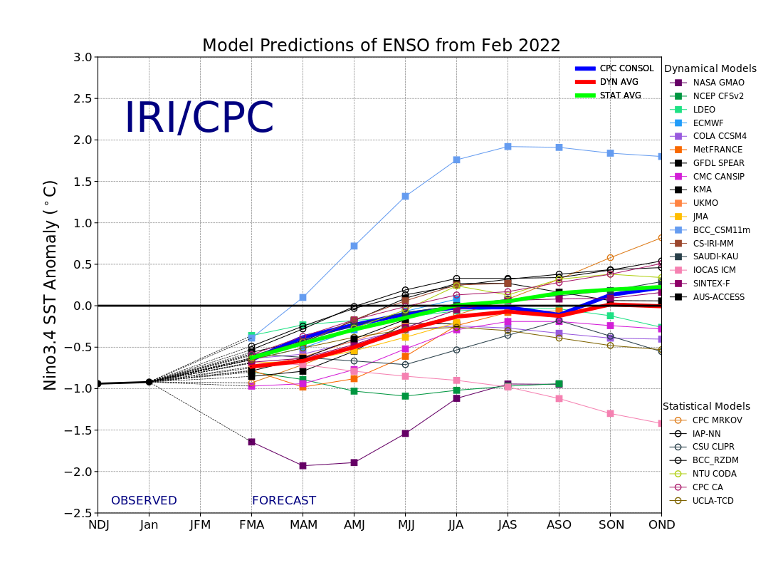
DorkyMcDorkface wrote:If we somehow manage to triple dip it would be the first time since 1998-2000 where we've had three successive Niña episodes in the Pacific. Additionally, history does does show that El Niño episodes are almost guaranteed to occur the year after, so we would likely be in prime position for one in 2023. But of course that all depends on what happens these next few months regarding the MJO. If it continues to stall in the Indian Ocean then yes, +ENSO prospects this year would lower dramatically, but it's a different story if it does manage to eventually break on through into the Pacific, as it shouldn't take much of a WWB to guide the subsurface warm pool to the surface. It's because of said warm pool that I do believe we have a better chance at warm neutral/El Niño than last year, but again, if the MJO continues to constructively interfere with the current Niña base state then Upwelling KWs can stall its progress and perhaps cause it to wither away.


Agreed about 2023 that is going to have a bonifide El Niño but in the meantime, we will have to deal with another active Atlantic hurricane season in 2022.
0 likes   
Visit the Caribbean-Central America Weather Thread where you can find at first post web cams,radars
and observations from Caribbean basin members Click Here

User avatar
Kingarabian
S2K Supporter
S2K Supporter
Posts: 15980
Joined: Sat Aug 08, 2009 3:06 am
Location: Honolulu, Hawaii

Re: ENSO Updates

#12304 Postby Kingarabian » Sat Feb 12, 2022 12:44 pm

Oceanic kelvin wave activity for the past year:
Image

Looking at March and April 2021, shows how important it is to get atmospheric coupling while the downwelling KW's are in place. Or else that El Nino potential is wasted. We'll see if a cold pool will follow this warm pool by about mid March.
5 likes   
RIP Kobe Bryant

AlphaToOmega
Category 5
Category 5
Posts: 1448
Joined: Sat Jun 26, 2021 10:51 am
Location: Somewhere in Massachusetts

Re: ENSO Updates

#12305 Postby AlphaToOmega » Sat Feb 12, 2022 3:11 pm

Kingarabian wrote:Oceanic kelvin wave activity for the past year:
https://i.imgur.com/0darLN3.png

Looking at March and April 2021, shows how important it is to get atmospheric coupling while the downwelling KW's are in place. Or else that El Nino potential is wasted. We'll see if a cold pool will follow this warm pool by about mid March.


The downwelling KWs certainly have warmed the Nino 4 region, though.
0 likes   

User avatar
cycloneye
Admin
Admin
Posts: 145295
Age: 68
Joined: Thu Oct 10, 2002 10:54 am
Location: San Juan, Puerto Rico

Re: ENSO Updates

#12306 Postby cycloneye » Tue Feb 15, 2022 9:52 am

1 likes   
Visit the Caribbean-Central America Weather Thread where you can find at first post web cams,radars
and observations from Caribbean basin members Click Here

AlphaToOmega
Category 5
Category 5
Posts: 1448
Joined: Sat Jun 26, 2021 10:51 am
Location: Somewhere in Massachusetts

Re: ENSO Updates

#12307 Postby AlphaToOmega » Wed Feb 16, 2022 6:01 am

MAM will be a very critical time for ENSO development. Any small westerly or easterly wind burst could tip the odds in favor of an El Nino or a La Nina respectively.
[Image
0 likes   

User avatar
NotSparta
Professional-Met
Professional-Met
Posts: 1668
Age: 23
Joined: Fri Aug 18, 2017 8:24 am
Location: Naples, FL
Contact:

Re: ENSO Updates

#12308 Postby NotSparta » Wed Feb 16, 2022 8:15 am

AlphaToOmega wrote:MAM will be a very critical time for ENSO development. Any small westerly or easterly wind burst could tip the odds in favor of an El Nino or a La Nina respectively.
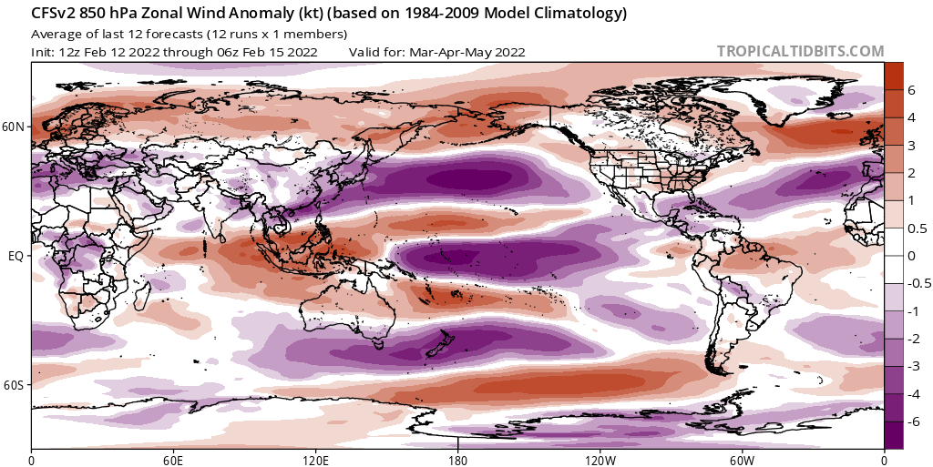
[https://i.postimg.cc/FFwDpbhq/cfs-mon-01-u850a-Mean-month-global-1.png


Yeah, that's why some climate models (CFS being one of the most) keep us in -ENSO. Easterlies during that period. However these models have trouble handling the MJO so I wouldn't hang my hat on them
1 likes   
This post was probably an opinion of mine, and in no way is official. Please refer to http://www.hurricanes.gov for official tropical analysis and advisories.

My website, with lots of tropical wx graphics, including satellite and recon: http://cyclonicwx.com

User avatar
Yellow Evan
Professional-Met
Professional-Met
Posts: 16143
Age: 27
Joined: Fri Jul 15, 2011 12:48 pm
Location: Henderson, Nevada/Honolulu, HI
Contact:

Re: ENSO Updates

#12309 Postby Yellow Evan » Thu Feb 17, 2022 1:10 pm

January 2022 PDO is out:

2021-10 -2.1850
2021-11 -1.8904
2021-12 -1.9434
2022-01 -1.5440


https://www.data.jma.go.jp/gmd/kaiyou/d ... do/pdo.txt

Honestly while the pattern in the Pacific screams an eventful transition to +PDO, the current value in itself is not conducive for a Nino.
2 likes   

User avatar
Kingarabian
S2K Supporter
S2K Supporter
Posts: 15980
Joined: Sat Aug 08, 2009 3:06 am
Location: Honolulu, Hawaii

Re: ENSO Updates

#12310 Postby Kingarabian » Thu Feb 17, 2022 3:24 pm

GFS will soon start showing a strong MJO entering the WPAC by the end of the first week of March. As it normally does every spring.
1 likes   
RIP Kobe Bryant

User avatar
Yellow Evan
Professional-Met
Professional-Met
Posts: 16143
Age: 27
Joined: Fri Jul 15, 2011 12:48 pm
Location: Henderson, Nevada/Honolulu, HI
Contact:

Re: ENSO Updates

#12311 Postby Yellow Evan » Fri Feb 18, 2022 1:52 pm

Kingarabian wrote:GFS will soon start showing a strong MJO entering the WPAC by the end of the first week of March. As it normally does every spring.


Image
0 likes   

User avatar
Category5Kaiju
Category 5
Category 5
Posts: 4095
Joined: Thu Dec 24, 2020 12:45 pm
Location: Seattle

Re: ENSO Updates

#12312 Postby Category5Kaiju » Fri Feb 18, 2022 2:29 pm

Yellow Evan wrote:
Kingarabian wrote:GFS will soon start showing a strong MJO entering the WPAC by the end of the first week of March. As it normally does every spring.


https://cdn.discordapp.com/attachments/733554252567281754/944210789844283392/image0.jpg


What exactly does that image show, if you don't mind me asking?
0 likes   
Unless explicitly stated, all info in my posts is based on my own opinions and observations. Tropical storms and hurricanes can be extremely dangerous. Do not think you can beat Mother Nature. Refer to an accredited weather research agency or meteorologist if you need to make serious decisions regarding an approaching storm.

AlphaToOmega
Category 5
Category 5
Posts: 1448
Joined: Sat Jun 26, 2021 10:51 am
Location: Somewhere in Massachusetts

Re: ENSO Updates

#12313 Postby AlphaToOmega » Fri Feb 18, 2022 2:33 pm

Category5Kaiju wrote:
Yellow Evan wrote:
Kingarabian wrote:GFS will soon start showing a strong MJO entering the WPAC by the end of the first week of March. As it normally does every spring.


https://cdn.discordapp.com/attachments/733554252567281754/944210789844283392/image0.jpg


What exactly does that image show, if you don't mind me asking?


It is showing easterlies over the tropical western Pacific Ocean.
0 likes   

User avatar
Category5Kaiju
Category 5
Category 5
Posts: 4095
Joined: Thu Dec 24, 2020 12:45 pm
Location: Seattle

Re: ENSO Updates

#12314 Postby Category5Kaiju » Fri Feb 18, 2022 3:08 pm

AlphaToOmega wrote:
Category5Kaiju wrote:


What exactly does that image show, if you don't mind me asking?


It is showing easterlies over the tropical western Pacific Ocean.


Easterlies? Wouldn't that really shut down the chance of El Nino, let alone a +ENSO state?
0 likes   
Unless explicitly stated, all info in my posts is based on my own opinions and observations. Tropical storms and hurricanes can be extremely dangerous. Do not think you can beat Mother Nature. Refer to an accredited weather research agency or meteorologist if you need to make serious decisions regarding an approaching storm.

User avatar
Yellow Evan
Professional-Met
Professional-Met
Posts: 16143
Age: 27
Joined: Fri Jul 15, 2011 12:48 pm
Location: Henderson, Nevada/Honolulu, HI
Contact:

Re: ENSO Updates

#12315 Postby Yellow Evan » Fri Feb 18, 2022 3:26 pm

AlphaToOmega wrote:
Category5Kaiju wrote:


What exactly does that image show, if you don't mind me asking?


It is showing easterlies over the tropical western Pacific Ocean.


Only east of 140E. You can see the clear westerlies further west, likely due to the incoming MJO.
0 likes   

User avatar
Kingarabian
S2K Supporter
S2K Supporter
Posts: 15980
Joined: Sat Aug 08, 2009 3:06 am
Location: Honolulu, Hawaii

Re: ENSO Updates

#12316 Postby Kingarabian » Fri Feb 18, 2022 4:25 pm

Yellow Evan wrote:
Kingarabian wrote:GFS will soon start showing a strong MJO entering the WPAC by the end of the first week of March. As it normally does every spring.


https://cdn.discordapp.com/attachments/733554252567281754/944210789844283392/image0.jpg


We'll see if it verifies and how far east it can get into the WPAC as the time frame comes in. GFS did a lot better than the Euro and CFS with calling for a big IO MJO event back in late December, while those two were calling for it be in the WPAC. Right now the Euro and the CFS are calling for a much weaker MC/WPAC MJO.
1 likes   
RIP Kobe Bryant

AlphaToOmega
Category 5
Category 5
Posts: 1448
Joined: Sat Jun 26, 2021 10:51 am
Location: Somewhere in Massachusetts

Re: ENSO Updates

#12317 Postby AlphaToOmega » Sat Feb 19, 2022 12:41 pm

As we go into March, the MJO patterns will decide everything.
Image
Image
0 likes   

User avatar
Kingarabian
S2K Supporter
S2K Supporter
Posts: 15980
Joined: Sat Aug 08, 2009 3:06 am
Location: Honolulu, Hawaii

Re: ENSO Updates

#12318 Postby Kingarabian » Sat Feb 19, 2022 2:36 pm


That GFS MJO forecast can be interpolated into a strong WPAC MJO even though it's not in range yet. But the GFS literally always shows a big WPAC MJO at this time of the year.
So we have to take it with a grain of salt.

We don't know how strong the upcoming upwelling KW will be. We probably need a significant MJO in the WPAC to shift things back to El Nino. it's debatable that a simple WPAC MJO passage will be any help if that upwelling KW is strong.

Image
Image
1 likes   
RIP Kobe Bryant

AlphaToOmega
Category 5
Category 5
Posts: 1448
Joined: Sat Jun 26, 2021 10:51 am
Location: Somewhere in Massachusetts

Re: ENSO Updates

#12319 Postby AlphaToOmega » Sat Feb 19, 2022 3:08 pm

The February CPC/IRI average is neutral until OND, but there is still no consensus.
Image
1 likes   

User avatar
Yellow Evan
Professional-Met
Professional-Met
Posts: 16143
Age: 27
Joined: Fri Jul 15, 2011 12:48 pm
Location: Henderson, Nevada/Honolulu, HI
Contact:

Re: ENSO Updates

#12320 Postby Yellow Evan » Tue Feb 22, 2022 9:14 pm

3 likes   


Return to “Talkin' Tropics”

Who is online

Users browsing this forum: gib, Hurricane2022, HurricaneFan, RomP and 49 guests