2022 Indicators (SSTs/SAL/MSLP/Shear/Steering/Instability) and >Day 16 Models
Moderator: S2k Moderators
Forum rules

The posts in this forum are NOT official forecasts and should not be used as such. They are just the opinion of the poster and may or may not be backed by sound meteorological data. They are NOT endorsed by any professional institution or STORM2K. For official information, please refer to products from the National Hurricane Center and National Weather Service.
-
Category5Kaiju

- Category 5

- Posts: 4346
- Joined: Thu Dec 24, 2020 12:45 pm
- Location: Seattle during the summer, Phoenix during the winter
Re: 2022 indicators: SSTs / SAL / MSLP / shear / steering / instability / images
While we are rightfully and obviously fixated on how the ENSO state progresses, there's no denying that if the current Atlantic sst anomaly profile holds, then we will likely be in for yet another busy year solely based on thermodynamics.
1 likes
Unless explicitly stated, all information in my posts is based on my own opinions and observations. Tropical storms and hurricanes can be extremely dangerous. Refer to an accredited weather research agency or meteorologist if you need to make serious decisions regarding an approaching storm.
-
AlphaToOmega
- Category 5
- Posts: 1448
- Joined: Sat Jun 26, 2021 10:51 am
- Location: Somewhere in Massachusetts
Re: 2022 indicators: SSTs / SAL / MSLP / shear / steering / instability / images
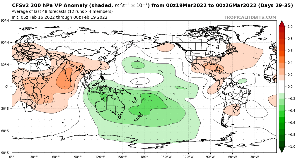
Assuming this verifies and is a harbinger for the rest of spring, it would mean that +ENSO is becoming less likely. We should still not call it before the spring, but trends look strong for a La Nina (i.e. a dry Sun Belt, a warm Pacific Northwest, and an inactive Pacific Hurricane Season). The CFSv2 is showing a strong MJO over the Maritime Continent, only to have it weaken once it enters the West Pacific.
1 likes
-
AlphaToOmega
- Category 5
- Posts: 1448
- Joined: Sat Jun 26, 2021 10:51 am
- Location: Somewhere in Massachusetts
Re: 2022 indicators: SSTs / SAL / MSLP / shear / steering / instability / images
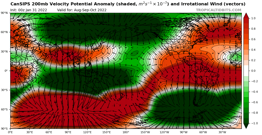
So... I guess the CanSIPS has a very creative interpretation of ASO
0 likes
-
Yellow Evan

- Professional-Met

- Posts: 16257
- Age: 27
- Joined: Fri Jul 15, 2011 12:48 pm
- Location: Henderson, Nevada/Honolulu, HI
- Contact:
Re: 2022 indicators: SSTs / SAL / MSLP / shear / steering / instability / images
AlphaToOmega wrote:So... I guess the CanSIPS has a very creative interpretation of ASO
https://i.postimg.cc/fLnH1CyT/cansips-chi200-Mean-month-global-7.png
This is simply a sign of screwed up model physics.
1 likes
-
AlphaToOmega
- Category 5
- Posts: 1448
- Joined: Sat Jun 26, 2021 10:51 am
- Location: Somewhere in Massachusetts
Re: 2022 indicators: SSTs / SAL / MSLP / shear / steering / instability / images
Yellow Evan wrote:AlphaToOmega wrote:So... I guess the CanSIPS has a very creative interpretation of ASO
https://i.postimg.cc/fLnH1CyT/cansips-chi200-Mean-month-global-7.png
This is simply a sign of screwed up model physics.
They need to fix that ROFL
0 likes
-
AlphaToOmega
- Category 5
- Posts: 1448
- Joined: Sat Jun 26, 2021 10:51 am
- Location: Somewhere in Massachusetts
Re: 2022 indicators: SSTs / SAL / MSLP / shear / steering / instability / images
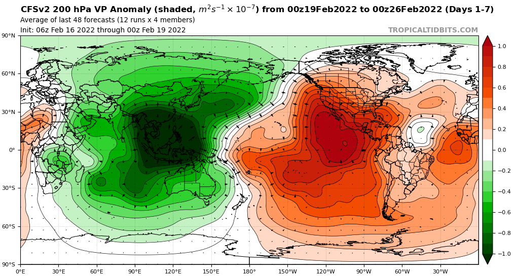
According to this, we would be seeing two major easterly wind bursts over the equatorial Pacific over the next few weeks. Fortunately, this means very little, for spring does not start until March 20.
2 likes
-
AlphaToOmega
- Category 5
- Posts: 1448
- Joined: Sat Jun 26, 2021 10:51 am
- Location: Somewhere in Massachusetts
Re: 2022 indicators: SSTs / SAL / MSLP / shear / steering / instability / images
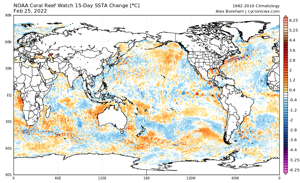
For people sensitive to current conditions, this should be a matter of some relief to those people. The MDR has cooled significantly compared to average, and the Atlantic Nino has done the opposite. An Atlantic Nino would push the ITCZ farther south, limiting late-season development. Pre-season fluctuations happen, and pre-season conditions mean absolutely nothing for the upcoming season.
1 likes
-
Kingarabian

- S2K Supporter

- Posts: 16379
- Joined: Sat Aug 08, 2009 3:06 am
- Location: Honolulu, Hawaii
Re: 2022 indicators: SSTs / SAL / MSLP / shear / steering / instability / images
1 likes
RIP Kobe Bryant
-
wxman57

- Moderator-Pro Met

- Posts: 23175
- Age: 68
- Joined: Sat Jun 21, 2003 8:06 pm
- Location: Houston, TX (southwest)
Re: 2022 indicators: SSTs / SAL / MSLP / shear / steering / instability / images
Most seasonal signals point to above-average activity this year. Probably neutral Nino 3.4 area, so no inhibiting factor of El Nino. AMO is about neutral now, after being warm for the past 6 months or so. Hard to predict where it will be this summer. No real inhibiting factor.
6 likes
-
SFLcane

- S2K Supporter
- Posts: 10281
- Age: 48
- Joined: Sat Jun 05, 2010 1:44 pm
- Location: Lake Worth Florida
Re: 2022 indicators: SSTs / SAL / MSLP / shear / steering / instability / images
wxman57 wrote:Most seasonal signals point to above-average activity this year. Probably neutral Nino 3.4 area, so no inhibiting factor of El Nino. AMO is about neutral now, after being warm for the past 6 months or so. Hard to predict where it will be this summer. No real inhibiting factor.
Busy year ahead folks potentially..wxman57 onboard
0 likes
-
AlphaToOmega
- Category 5
- Posts: 1448
- Joined: Sat Jun 26, 2021 10:51 am
- Location: Somewhere in Massachusetts
Re: 2022 indicators: SSTs / SAL / MSLP / shear / steering / instability / images
SFLcane wrote:wxman57 wrote:Most seasonal signals point to above-average activity this year. Probably neutral Nino 3.4 area, so no inhibiting factor of El Nino. AMO is about neutral now, after being warm for the past 6 months or so. Hard to predict where it will be this summer. No real inhibiting factor.
Busy year ahead folks potentially..wxman57 onboard
It is early, but things seem favorable for an active season just from looking at the models: Africa will likely make the AMM positive; the ENSO is shaping up to be negative (not ready to make a definitive call, it could always surprise us with an El Nino); the MDR could be significantly above-average this year. However, these were things both 2020 and 2021 shared. We know nothing in terms of MJO strength, though; if the MJO is strong, that means the windows of opportunity for development would be shorter and vice-versa. We also know nothing about the Atlantic Nino; if that is strongly positive, the ITCZ would be suppressed to the south, suppressing Caribbean development; also, the strong Atlantic Nino we saw last year caused the MDR to be so cold that the AMM was just barely positive for ASO (positive by around 0.1). We just have to wait and see.
1 likes
-
Category5Kaiju
- Category 5
- Posts: 4346
- Joined: Thu Dec 24, 2020 12:45 pm
- Location: Seattle during the summer, Phoenix during the winter
Re: 2022 indicators: SSTs / SAL / MSLP / shear / steering / instability / images
It's honestly stunning to see how signs are pointing possibly toward a seventh above average Atlantic season. Since 2016, whether it's due to a highly fortuitous ENSO state evolution or some other factor, the Atlantic has been genuinely relentless.
3 likes
Unless explicitly stated, all information in my posts is based on my own opinions and observations. Tropical storms and hurricanes can be extremely dangerous. Refer to an accredited weather research agency or meteorologist if you need to make serious decisions regarding an approaching storm.
-
AnnularCane

- S2K Supporter
- Posts: 2964
- Joined: Thu Jun 08, 2006 9:18 am
- Location: Wytheville, VA
Re: 2022 indicators: SSTs / SAL / MSLP / shear / steering / instability / images
Category5Kaiju wrote:It's honestly stunning to see how signs are pointing possibly toward a seventh above average Atlantic season. Since 2016, whether it's due to a highly fortuitous ENSO state evolution or some other factor, the Atlantic has been genuinely relentless.
I know, I halfway wasn't expecting it and have kind of a "believe it when I see it" attitude.
Also maybe because of course, it's still a little early.
0 likes
"But it never rained rain. It never snowed snow. And it never blew just wind. It rained things like soup and juice. It snowed mashed potatoes and green peas. And sometimes the wind blew in storms of hamburgers." -- Judi Barrett, Cloudy with a Chance of Meatballs
-
DorkyMcDorkface

- Category 5
- Posts: 1043
- Age: 28
- Joined: Mon Sep 30, 2019 1:32 pm
- Location: Mid-Atlantic
Re: 2022 indicators: SSTs / SAL / MSLP / shear / steering / instability / images
Category5Kaiju wrote:It's honestly stunning to see how signs are pointing possibly toward a seventh above average Atlantic season. Since 2016, whether it's due to a highly fortuitous ENSO state evolution or some other factor, the Atlantic has been genuinely relentless.
The active WAM is definitely one of the main culprits to blame for this current high-activity streak. Strong wave train, warms up MDR in time for peak season, handicaps +ENSO...pretty much a perfect storm of sorts (no pun intended
7 likes
Please note the thoughts expressed by this account are solely those of the user and are from a hobbyist perspective. For more comprehensive analysis, consult an actual professional meteorologist or meteorological agency.
Floyd 1999 | Isabel 2003 | Hanna 2008 | Irene 2011 | Sandy 2012 | Isaias 2020
-
Category5Kaiju
- Category 5
- Posts: 4346
- Joined: Thu Dec 24, 2020 12:45 pm
- Location: Seattle during the summer, Phoenix during the winter
Re: 2022 indicators: SSTs / SAL / MSLP / shear / steering / instability / images
DorkyMcDorkface wrote:Category5Kaiju wrote:It's honestly stunning to see how signs are pointing possibly toward a seventh above average Atlantic season. Since 2016, whether it's due to a highly fortuitous ENSO state evolution or some other factor, the Atlantic has been genuinely relentless.
The active WAM is definitely one of the main culprits to blame for this current high-activity streak. Strong wave train, warms up MDR in time for peak season, handicaps +ENSO...pretty much a perfect storm of sorts (no pun intended) to produce a consistently active Atlantic. Wonder how long it could last - definitely a possibility that AGW could be prolonging this strong WAM/ASW period for much longer than anticipated and may also be contributing to its dominance in the global atmospheric circulation as well. Something to think about for sure.
You know, at this point, I just have to wonder this: as long as that strong WAM lasts, I am curious to see if that actually serves as an external factor in unfavorably rigging the chances of a solid El Nino from happening. If for whatever reason 2023 does not bring an El Nino (that'll be an issue worth talking about after this season), then I would be truly amazed.
0 likes
Unless explicitly stated, all information in my posts is based on my own opinions and observations. Tropical storms and hurricanes can be extremely dangerous. Refer to an accredited weather research agency or meteorologist if you need to make serious decisions regarding an approaching storm.
-
SFLcane
- S2K Supporter
- Posts: 10281
- Age: 48
- Joined: Sat Jun 05, 2010 1:44 pm
- Location: Lake Worth Florida
Re: 2022 indicators: SSTs / SAL / MSLP / shear / steering / instability / images
Just have that feeling it’s going to be another wild season. 
https://twitter.com/bennollweather/status/1498727519238774784
https://twitter.com/bennollweather/status/1498727519238774784
2 likes
-
cycloneye

- Admin

- Posts: 149716
- Age: 69
- Joined: Thu Oct 10, 2002 10:54 am
- Location: San Juan, Puerto Rico
Re: 2022 indicators: SSTs / SAL / MSLP / shear / steering / instability / images
SFLcane wrote:Just have that feeling it’s going to be another wild season.
https://twitter.com/bennollweather/status/1498727519238774784?
When you begin to open eyes so early, yikes.
0 likes
Visit the Caribbean-Central America Weather Thread where you can find at first post web cams,radars
and observations from Caribbean basin members Click Here
and observations from Caribbean basin members Click Here
-
AlphaToOmega
- Category 5
- Posts: 1448
- Joined: Sat Jun 26, 2021 10:51 am
- Location: Somewhere in Massachusetts
Re: 2022 indicators: SSTs / SAL / MSLP / shear / steering / instability / images
SFLcane wrote:Just have that feeling it’s going to be another wild season.
https://twitter.com/bennollweather/status/1498727519238774784?
So far, the CanSIPS has been crap with VP anomalies.
1 likes
-
DorkyMcDorkface
- Category 5
- Posts: 1043
- Age: 28
- Joined: Mon Sep 30, 2019 1:32 pm
- Location: Mid-Atlantic
Re: 2022 indicators: SSTs / SAL / MSLP / shear / steering / instability / images
AlphaToOmega wrote:SFLcane wrote:Just have that feeling it’s going to be another wild season.
https://twitter.com/bennollweather/status/1498727519238774784?
So far, the CanSIPS has been crap with VP anomalies.
Everything but the SST graphics has been bugged for the longest time on Tropical Tidbits, not sure what is going on.
I do have a subscription to weathermodels.com, however, and the precip anomaly maps are fine on there interestingly enough:

1 likes
Please note the thoughts expressed by this account are solely those of the user and are from a hobbyist perspective. For more comprehensive analysis, consult an actual professional meteorologist or meteorological agency.
Floyd 1999 | Isabel 2003 | Hanna 2008 | Irene 2011 | Sandy 2012 | Isaias 2020
-
SFLcane
- S2K Supporter
- Posts: 10281
- Age: 48
- Joined: Sat Jun 05, 2010 1:44 pm
- Location: Lake Worth Florida
Re: 2022 indicators: SSTs / SAL / MSLP / shear / steering / instability / images
These waters are going to be much warmer come April! Not many if any cold fronts coming. Quite impressive and already supports a cat 2 in March.
https://twitter.com/stormchaserjs/status/1499012508220280836
https://twitter.com/stormchaserjs/status/1499012508220280836
1 likes
Who is online
Users browsing this forum: bird, TeamPlayersBlue, wxman22 and 239 guests