Texas Spring 2022
Moderator: S2k Moderators
Forum rules

The posts in this forum are NOT official forecast and should not be used as such. They are just the opinion of the poster and may or may not be backed by sound meteorological data. They are NOT endorsed by any professional institution or STORM2K.
-
rwfromkansas
- Category 5

- Posts: 3032
- Joined: Sat Aug 27, 2005 12:47 am
- Location: North Fort Worth
Re: Texas Spring 2022
Well, all models show zip currently. Will see....maybe can get something still. Not giving up hope yet.
0 likes
-
orangeblood
- S2K Supporter

- Posts: 3895
- Joined: Tue Dec 15, 2009 6:14 pm
- Location: Fort Worth, TX
Re: Texas Spring 2022
Almost every model now has the energy coming out of the southwest getting sheared out by northern feature, not looking good for winter weather on Friday. The system doesn't really get going until well east of here
1 likes


Re: Texas Spring 2022
Well I guess if you're in a drought, you expect the pattern to reflect it.
2 likes
The above post and any post by Ntxw is NOT an official forecast and should not be used as such. It is just the opinion of the poster and may or may not be backed by sound meteorological data. It is NOT endorsed by any professional institution including Storm2k. For official information, please refer to NWS products.
Help support Storm2K!
-
Haris

- Category 5
- Posts: 1814
- Joined: Mon Nov 27, 2017 8:19 pm
- Location: ( Bee Cave) West Austin, Texas
Re: Texas Spring 2022
Glad winter is over. Just so crappy seeing every system, rain or snow, disappear. The only time it rained this whole winter in Austin really was the Early Feb event.

2 likes
Weather geek and a storm spotter in West Austin. Not a degreed meteorologist. Big snow fan. Love rain and cold! Despise heat!
-
txtwister78

- Category 5
- Posts: 2178
- Joined: Wed Jan 30, 2019 12:56 pm
- Location: San Antonio
Re: Texas Spring 2022
Yeah once again we've seen this rerun before....TX has been locked in to this pattern (La Nina influenced) for months and outside of the one big ice event in early Feb, it's been the same tired script regarding lack of precip (very little if any southern branch/pacific moisture to work with). Not surprised by it at all. Until we get out from under this pattern, I wouldn't trust models more than two days out as it relates to precip output and so I'm not even sure I would call this a bust in that the end result has been been fairly consistent throughout the entire winter.
0 likes

Re: Texas Spring 2022
txtwister78 wrote:Yeah once again we've seen this rerun before....TX has been locked in to this pattern (La Nina influenced) for months and outside of the one big ice event in early Feb, it's been the same tired script regarding lack of precip (very little if any southern branch/pacific moisture to work with). Not surprised by it at all. Until we get out from under this pattern, I wouldn't trust models more than two days out as it relates to precip output and so I'm not even sure I would call this a bust in that the end result has been been fairly consistent throughout the entire winter.
I hear La Niña isn’t going anywhere anytime soon either.
0 likes
-
rwfromkansas
- Category 5
- Posts: 3032
- Joined: Sat Aug 27, 2005 12:47 am
- Location: North Fort Worth
Re: Texas Spring 2022
I really hope we get a neutral winter, but La Nina is just so stubborn.
We will be in for a megadrought potentially.
We will be in for a megadrought potentially.
0 likes

Re: Texas Spring 2022
Ntxw wrote:Well I guess if you're in a drought, you expect the pattern to reflect it.
Harold Taft (and no doubt many others) once said "a drought always ends in a flood, and a flood always ends in a drought." It's frustrating to see the losing streak we're on - where basically models come in bullish on QPF only to see that everything fizzles. Other than the nice soaking we got leading up to the 2/2 winter storm, we've been on the losing end of virtually every system since last fall. Once summer gets here the feedback loop will be hard to ignore. I guess we hope for an over-active tropics season or maybe we get lucky with an active Eastern Pacific storm season to funnel moisture over Mexico to us?
0 likes
-
txtwister78
- Category 5
- Posts: 2178
- Joined: Wed Jan 30, 2019 12:56 pm
- Location: San Antonio
Re: Texas Spring 2022
DallasAg wrote:Ntxw wrote:Well I guess if you're in a drought, you expect the pattern to reflect it.
Harold Taft (and no doubt many others) once said "a drought always ends in a flood, and a flood always ends in a drought." It's frustrating to see the losing streak we're on - where basically models come in bullish on QPF only to see that everything fizzles. Other than the nice soaking we got leading up to the 2/2 winter storm, we've been on the losing end of virtually every system since last fall. Once summer gets here the feedback loop will be hard to ignore. I guess we hope for an over-active tropics season or maybe we get lucky with an active Eastern Pacific storm season to funnel moisture over Mexico to us?
Seeing some early signs/signals for an active tropics in the gulf for the upcoming hurricane season and so hopefully that comes to fruition in terms of adding some beneficial rainfall and alleviating whatever drought conditions that exist across the state. That's typically been our source region for busting droughts when we've been locked into a pattern like this and from the looks of this graphic, that's probably what we're going to be forced into relying on unfortunately (the other risks associated with tropics).
In the short range, I've seen some chatter on social media about a potential severe weather event late next week across portions of N & Central TX, but once again seeing is believing at his point and so definitely not biting on that just yet.
Last edited by txtwister78 on Wed Mar 09, 2022 12:32 pm, edited 1 time in total.
1 likes
Re: Texas Spring 2022
txtwister78 wrote:DallasAg wrote:Ntxw wrote:Well I guess if you're in a drought, you expect the pattern to reflect it.
Harold Taft (and no doubt many others) once said "a drought always ends in a flood, and a flood always ends in a drought." It's frustrating to see the losing streak we're on - where basically models come in bullish on QPF only to see that everything fizzles. Other than the nice soaking we got leading up to the 2/2 winter storm, we've been on the losing end of virtually every system since last fall. Once summer gets here the feedback loop will be hard to ignore. I guess we hope for an over-active tropics season or maybe we get lucky with an active Eastern Pacific storm season to funnel moisture over Mexico to us?
Seeing some early signs/signals for an active tropics in the gulf for the upcoming hurricane season and so hopefully that comes to fruition in terms of adding some beneficial rainfall and alleviating whatever drought conditions that exist across the state. That's typically been our source region for busting droughts when we've been locked into a pattern like this.
In the short range, I've seen some chatter on social media about a potential severe weather event late next week across portions of N & Central TX, but once again seeing is believing at his point and so definitely not biting on that just yet.
It would be nice to see an active gulf/tropics (but nothing severe). The daunting task is while ENSO and seasonal variability happens, I'm afraid we've only recently seen the -PDO hit so it is quite young in development. It's a decadal oscillation so it will last several more years to come as it's a slow process hence the term it is derived from. So in short, the dry patterns will prevail with possible breaks in between.
That's how it typically plays out, first the Pacific shifts mode followed by persistent dry patterns. In the beginning it is mostly an atmospheric drought followed by soil drought. Last in line is the hydrological system, lakes and water storage, that gets hit last.
0 likes
The above post and any post by Ntxw is NOT an official forecast and should not be used as such. It is just the opinion of the poster and may or may not be backed by sound meteorological data. It is NOT endorsed by any professional institution including Storm2k. For official information, please refer to NWS products.
Help support Storm2K!
Help support Storm2K!
Re: Texas Spring 2022
Next week looks warm and comfortable. Let's hope the heat holds off for a while because summer could be nasty I'm afraid.
1 likes
-
rwfromkansas
- Category 5
- Posts: 3032
- Joined: Sat Aug 27, 2005 12:47 am
- Location: North Fort Worth
Re: Texas Spring 2022
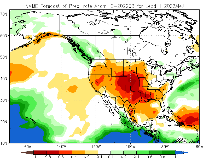
Huge portion of the country look to be in drought in that map. Depressing. I see lots of 100s this summer.
0 likes
-
Haris
- Category 5
- Posts: 1814
- Joined: Mon Nov 27, 2017 8:19 pm
- Location: ( Bee Cave) West Austin, Texas
Re: Texas Spring 2022
Euro keeps the snow chance alive for the metroplexers. I guess don't knock the chance off completely, but no doubt obviously the trends were negative. We'll see what short range models say I guess
3 likes
Weather geek and a storm spotter in West Austin. Not a degreed meteorologist. Big snow fan. Love rain and cold! Despise heat!
Re: Texas Spring 2022
Ntxw wrote:txtwister78 wrote:DallasAg wrote:Harold Taft (and no doubt many others) once said "a drought always ends in a flood, and a flood always ends in a drought." It's frustrating to see the losing streak we're on - where basically models come in bullish on QPF only to see that everything fizzles. Other than the nice soaking we got leading up to the 2/2 winter storm, we've been on the losing end of virtually every system since last fall. Once summer gets here the feedback loop will be hard to ignore. I guess we hope for an over-active tropics season or maybe we get lucky with an active Eastern Pacific storm season to funnel moisture over Mexico to us?
Seeing some early signs/signals for an active tropics in the gulf for the upcoming hurricane season and so hopefully that comes to fruition in terms of adding some beneficial rainfall and alleviating whatever drought conditions that exist across the state. That's typically been our source region for busting droughts when we've been locked into a pattern like this.
In the short range, I've seen some chatter on social media about a potential severe weather event late next week across portions of N & Central TX, but once again seeing is believing at his point and so definitely not biting on that just yet.
It would be nice to see an active gulf/tropics (but nothing severe). The daunting task is while ENSO and seasonal variability happens, I'm afraid we've only recently seen the -PDO hit so it is quite young in development. It's a decadal oscillation so it will last several more years to come as it's a slow process hence the term it is derived from. So in short, the dry patterns will prevail with possible breaks in between.
That's how it typically plays out, first the Pacific shifts mode followed by persistent dry patterns. In the beginning it is mostly an atmospheric drought followed by soil drought. Last in line is the hydrological system, lakes and water storage, that gets hit last.
What exactly is the Pacific Decadal Oscillation?
0 likes
-
CaptinCrunch

- S2K Supporter
- Posts: 8779
- Age: 58
- Joined: Mon Nov 03, 2003 4:33 pm
- Location: Kennedale, TX (Tarrant Co.)
Re: Texas Spring 2022
This Spring is already looking drier than normal, and when you see that severe weather is usually on the low end of the scale. Not saying there won't be any, but less opportunities for it.
As for Summer, I'm banking on a HOT dry summer, so I agree on the 100 degree days. Better get the AC tuned up I'm certain we are going to need it.
For the tropics being active, let's hope it stays to a minimum, but if those water temps hit high levels not only across the GOM but into the southern Atlantic then watch out for some monster canes.
2 likes
Re: Texas Spring 2022
Cpv17 wrote:Ntxw wrote:txtwister78 wrote:
Seeing some early signs/signals for an active tropics in the gulf for the upcoming hurricane season and so hopefully that comes to fruition in terms of adding some beneficial rainfall and alleviating whatever drought conditions that exist across the state. That's typically been our source region for busting droughts when we've been locked into a pattern like this.
In the short range, I've seen some chatter on social media about a potential severe weather event late next week across portions of N & Central TX, but once again seeing is believing at his point and so definitely not biting on that just yet.
It would be nice to see an active gulf/tropics (but nothing severe). The daunting task is while ENSO and seasonal variability happens, I'm afraid we've only recently seen the -PDO hit so it is quite young in development. It's a decadal oscillation so it will last several more years to come as it's a slow process hence the term it is derived from. So in short, the dry patterns will prevail with possible breaks in between.
That's how it typically plays out, first the Pacific shifts mode followed by persistent dry patterns. In the beginning it is mostly an atmospheric drought followed by soil drought. Last in line is the hydrological system, lakes and water storage, that gets hit last.
What exactly is the Pacific Decadal Oscillation?
It is sea spatial sea surface temperature anomaly tendencies over the North Pacific as a longer term background backed by ENSO. During -PDO, Ocean water along the west coast of North America tends to be colder than normal with a ring from Alaska to Mexico through the equatorial Pacific (Nina). Some question chicken or egg relationship. 2007-2014 during the last -PDO saw extreme drought, severe hot summers across the Great Plains, and La Ninas/cold neutral dominated this stretch.
2015-2020 saw the reverse during the +PDO and year after year we saw some record rains. Warm water prevailed along the North American west coast to tie in with El Nino in the tropics. It has since flipped back to severely negative.
El Nino/La Nina can flip year to year but the PDO is a slugging feature that can feed or abate an ENSO event.
https://www.ncdc.noaa.gov/teleconnections/pdo/
-PDO has one of the strongest correlations to our long term drought tendencies.
https://www.pnas.org/doi/10.1073/pnas.0306738101
2 likes
The above post and any post by Ntxw is NOT an official forecast and should not be used as such. It is just the opinion of the poster and may or may not be backed by sound meteorological data. It is NOT endorsed by any professional institution including Storm2k. For official information, please refer to NWS products.
Help support Storm2K!
Help support Storm2K!
-
Brent
- S2K Supporter
- Posts: 38741
- Age: 37
- Joined: Sun May 16, 2004 10:30 pm
- Location: Tulsa Oklahoma
- Contact:
Re: Texas Spring 2022
Cpv17 wrote:txtwister78 wrote:Yeah once again we've seen this rerun before....TX has been locked in to this pattern (La Nina influenced) for months and outside of the one big ice event in early Feb, it's been the same tired script regarding lack of precip (very little if any southern branch/pacific moisture to work with). Not surprised by it at all. Until we get out from under this pattern, I wouldn't trust models more than two days out as it relates to precip output and so I'm not even sure I would call this a bust in that the end result has been been fairly consistent throughout the entire winter.
I hear La Niña isn’t going anywhere anytime soon either.
Last I heard it's supposed to fade by summer but who knows. The February update had a 57 percent chance of neutral by June
But regardless if we can't get out of this drought yeah it's gonna be a very long summer
Last edited by Brent on Wed Mar 09, 2022 4:49 pm, edited 1 time in total.
0 likes
#neversummer
-
rwfromkansas
- Category 5
- Posts: 3032
- Joined: Sat Aug 27, 2005 12:47 am
- Location: North Fort Worth
Re: Texas Spring 2022
CaptinCrunch wrote:This Spring is already looking drier than normal, and when you see that severe weather is usually on the low end of the scale. Not saying there won't be any, but less opportunities for it.
As for Summer, I'm banking on a HOT dry summer, so I agree on the 100 degree days. Better get the AC tuned up I'm certain we are going to need it.
For the tropics being active, let's hope it stays to a minimum, but if those water temps hit high levels not only across the GOM but into the southern Atlantic then watch out for some monster canes.
Yeah, you need rain for severe weather....lol.
0 likes
-
bubba hotep

- S2K Supporter
- Posts: 6014
- Joined: Wed Dec 28, 2016 1:00 am
- Location: Collin County Texas
Re: Texas Spring 2022
18z HRRR & 3K NAM seem to favor the 12z Euro for N. Texas.
1 likes
Winter time post are almost exclusively focused on the DFW area.
-
Iceresistance

- Category 5
- Posts: 9583
- Age: 22
- Joined: Sat Oct 10, 2020 9:45 am
- Location: Tecumseh, OK/Norman, OK
Re: Texas Spring 2022
18z GEFS is also looking better, 2-3 inches 10:1 Ratio in Tulsa, 1-2 inches in OKC & Tecumseh
DFW gets a dusting
DFW gets a dusting
1 likes
Bill 2015 & Beta 2020
Winter 2020-2021
All observations are in Tecumseh, OK unless otherwise noted.
Winter posts are focused mainly for Oklahoma & Texas.
Take any of my forecasts with a grain of salt, refer to the NWS, SPC, and NHC for official information
Never say Never with weather! Because ANYTHING is possible!
Winter 2020-2021
All observations are in Tecumseh, OK unless otherwise noted.
Winter posts are focused mainly for Oklahoma & Texas.
Take any of my forecasts with a grain of salt, refer to the NWS, SPC, and NHC for official information
Never say Never with weather! Because ANYTHING is possible!
Return to “USA & Caribbean Weather”
Who is online
Users browsing this forum: No registered users and 250 guests