Texas Spring 2022

U.S. & Caribbean Weather Discussions and Severe Weather Events

Moderator: S2k Moderators

Forum rules

The posts in this forum are NOT official forecast and should not be used as such. They are just the opinion of the poster and may or may not be backed by sound meteorological data. They are NOT endorsed by any professional institution or STORM2K.

Help Support Storm2K
Message
Author
User avatar
bubba hotep
S2K Supporter
S2K Supporter
Posts: 5837
Joined: Wed Dec 28, 2016 1:00 am
Location: Collin County Texas

Re: Texas Spring 2022

#921 Postby bubba hotep » Mon Apr 04, 2022 8:55 pm

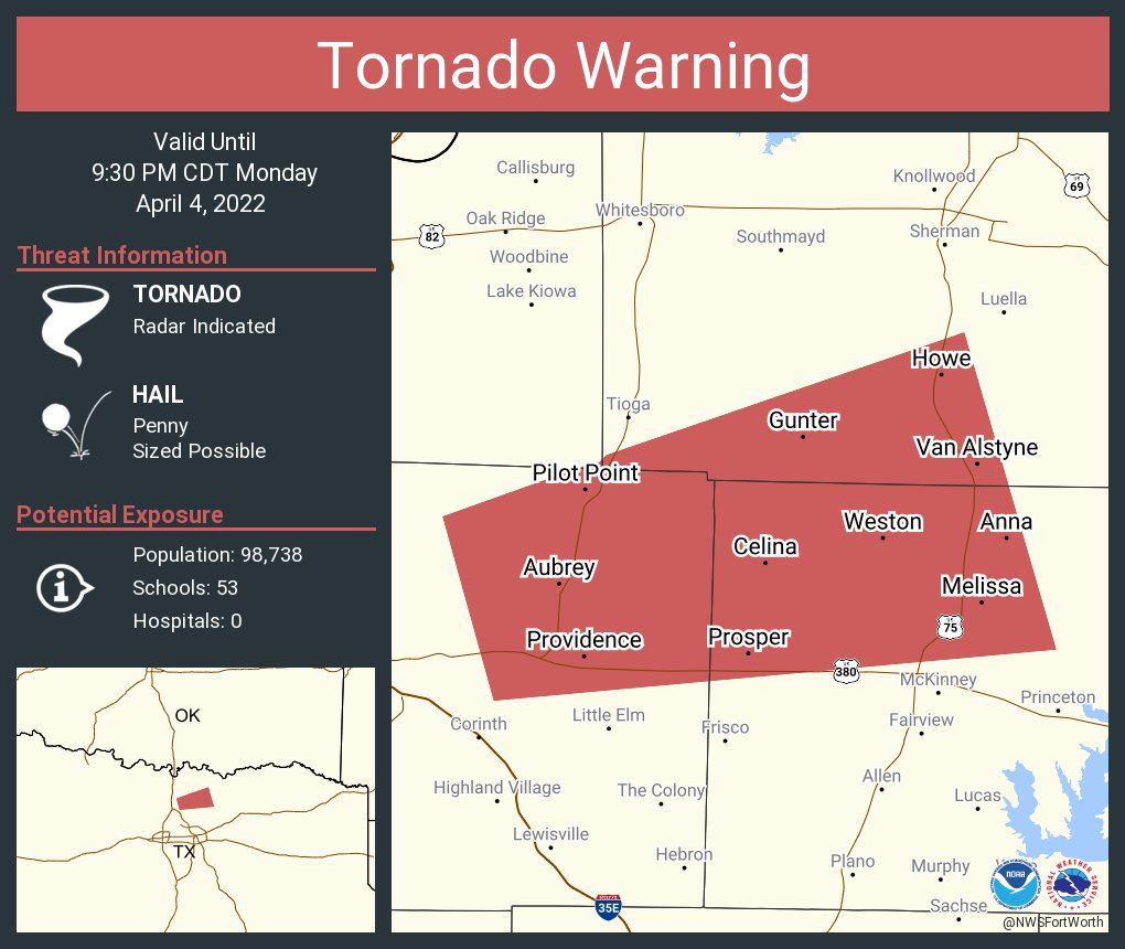
Weather Dude wrote:Tornado warning and solid meso just E of Denton


That cell has been riding right on that boundary that Ntxw mentioned a bit ago.

Image
0 likes   
Winter time post are almost exclusively focused on the DFW area.

User avatar
Quixotic
Category 2
Category 2
Posts: 729
Joined: Tue Feb 14, 2017 12:27 am
Location: Frisco

Re: Texas Spring 2022

#922 Postby Quixotic » Mon Apr 04, 2022 8:56 pm

Sirens going off here in Frisco
1 likes   

User avatar
cheezyWXguy
Category 5
Category 5
Posts: 6108
Joined: Mon Feb 13, 2006 12:29 am
Location: Dallas, TX

Re: Texas Spring 2022

#923 Postby cheezyWXguy » Mon Apr 04, 2022 8:57 pm

bubba hotep wrote:
rwfromkansas wrote:Tarrant getting the screw job again. Again. Just rinse and repeat.


Some storms building back to the SW. This will be a multicellular blob vs. a line of storms. Some places will only get one round but others will see multiple rounds, that's how the models get 3-4" in an area.


Storms are also trying to zipper down along the boundary instead of behind it like before. Should see some better development over the next hour, but it looks like i35 and east is gonna get the higher rain totals

Edit: also, that tor warning in Collin county looks like it’s wrapping up into an mcv. That may be the focal point that the mcs kind of pivots around as it gets going
Last edited by cheezyWXguy on Mon Apr 04, 2022 8:58 pm, edited 1 time in total.
0 likes   

rwfromkansas
Category 5
Category 5
Posts: 2627
Joined: Sat Aug 27, 2005 12:47 am
Location: North Fort Worth

Re: Texas Spring 2022

#924 Postby rwfromkansas » Mon Apr 04, 2022 8:58 pm

Looking like some more developing further back maybe behind the front at least.

The storm up north is nasty.
0 likes   

User avatar
ElectricStorm
Category 5
Category 5
Posts: 5044
Age: 24
Joined: Tue Aug 13, 2019 11:23 pm
Location: Skiatook, OK / Norman, OK

Re: Texas Spring 2022

#925 Postby ElectricStorm » Mon Apr 04, 2022 9:02 pm

Kinda looks like a new rotation is trying to form near Celina out in front of the main one

EDIT: Yeah it definitely is the old rotation is weakening
0 likes   
B.S Meteorology, University of Oklahoma '25

Please refer to the NHC, NWS, or SPC for official information.

User avatar
Texas Snowman
Storm2k Moderator
Storm2k Moderator
Posts: 6179
Joined: Fri Jan 25, 2008 11:29 am
Location: Denison, Texas

Re: Texas Spring 2022

#926 Postby Texas Snowman » Mon Apr 04, 2022 9:06 pm

@NWSFortWorth — 900pm: Celina and Weston in northern Collin county are directly in the path of strong rotation. This possible tornado is totally wrapped in rain and will not be visible. Get in your safe shelter now, lowest floor, and away from any windows. #dfwwx
1 likes   
The above post and any post by Texas Snowman is NOT an official forecast and should not be used as such. It is just the opinion of the poster and may or may not be backed by sound meteorological data. It is NOT endorsed by any professional institution including storm2k.org. For official information, please refer to NWS products.

User avatar
Texas Snowman
Storm2k Moderator
Storm2k Moderator
Posts: 6179
Joined: Fri Jan 25, 2008 11:29 am
Location: Denison, Texas

Re: Texas Spring 2022

#927 Postby Texas Snowman » Mon Apr 04, 2022 9:13 pm

250
WWUS54 KFWD 050206
SVSFWD

Severe Weather Statement
National Weather Service Fort Worth TX
906 PM CDT Mon Apr 4 2022


TXC085-181-050230-
/O.CON.KFWD.TO.W.0029.000000T0000Z-220405T0230Z/
Collin TX-Grayson TX-
906 PM CDT Mon Apr 4 2022

...A TORNADO WARNING REMAINS IN EFFECT UNTIL 930 PM CDT FOR
NORTHWESTERN COLLIN AND SOUTH CENTRAL GRAYSON COUNTIES...

At 906 PM CDT, a severe thunderstorm capable of producing a tornado
was located over Celina, or 9 miles northwest of McKinney, moving
east at 35 mph.

HAZARD...Tornado.

SOURCE...Radar indicated rotation.

IMPACT...Flying debris will be dangerous to those caught without
shelter. Mobile homes will be damaged or destroyed. Damage
to roofs, windows, and vehicles will occur. Tree damage is
likely.

This dangerous storm will be near...
McKinney around 910 PM CDT.
Anna around 930 PM CDT.

Other locations impacted by this tornadic thunderstorm include Weston
and Melissa.

PRECAUTIONARY/PREPAREDNESS ACTIONS...

TAKE COVER NOW! If you are outdoors, in a mobile home, or in a
vehicle, move to the closest substantial shelter now! Get to an
interior room on the lowest floor of a sturdy building and avoid
windows.

Tornadoes are extremely difficult to see and confirm at night. Do not
wait to see or hear the tornado. TAKE COVER NOW!

&&

LAT...LON 3324 9650 3324 9684 3343 9684 3354 9659
TIME...MOT...LOC 0206Z 271DEG 29KT 3331 9676

TORNADO...RADAR INDICATED
MAX HAIL SIZE...<.75 IN
1 likes   
The above post and any post by Texas Snowman is NOT an official forecast and should not be used as such. It is just the opinion of the poster and may or may not be backed by sound meteorological data. It is NOT endorsed by any professional institution including storm2k.org. For official information, please refer to NWS products.

HockeyTx82
S2K Supporter
S2K Supporter
Posts: 2540
Joined: Tue Oct 27, 2009 11:17 am
Location: Ponder, TX

Re: Texas Spring 2022

#928 Postby HockeyTx82 » Mon Apr 04, 2022 9:22 pm

1.26" of rain here in Ponder
3 likes   
Don't hold me accountable for anything I post on this forum. Leave the real forecasting up to the professionals.

Location: Ponder, TX (all observation posts are this location unless otherwise noted)

User avatar
cheezyWXguy
Category 5
Category 5
Posts: 6108
Joined: Mon Feb 13, 2006 12:29 am
Location: Dallas, TX

Re: Texas Spring 2022

#929 Postby cheezyWXguy » Mon Apr 04, 2022 9:23 pm

This line moving through looks to be the main chance for tornadoes, if any, but that secondary line back near mineral wells looks like the wind threat to me. Quite a wind surge showing up on velocity
1 likes   

User avatar
Texas Snowman
Storm2k Moderator
Storm2k Moderator
Posts: 6179
Joined: Fri Jan 25, 2008 11:29 am
Location: Denison, Texas

Re: Texas Spring 2022

#930 Postby Texas Snowman » Mon Apr 04, 2022 9:27 pm

As per KTEN Weather tweet, first responders are reporting a foot of water on Hwy. 289 (Preston Road) in Gunter.
1 likes   
The above post and any post by Texas Snowman is NOT an official forecast and should not be used as such. It is just the opinion of the poster and may or may not be backed by sound meteorological data. It is NOT endorsed by any professional institution including storm2k.org. For official information, please refer to NWS products.

HockeyTx82
S2K Supporter
S2K Supporter
Posts: 2540
Joined: Tue Oct 27, 2009 11:17 am
Location: Ponder, TX

Re: Texas Spring 2022

#931 Postby HockeyTx82 » Mon Apr 04, 2022 9:28 pm

Texas Snowman wrote:As per KTEN Weather tweet, first responders are reporting a foot of water on Hwy. 289 (Preston Road) in Gunter.


How do you end a drought?
1 likes   
Don't hold me accountable for anything I post on this forum. Leave the real forecasting up to the professionals.

Location: Ponder, TX (all observation posts are this location unless otherwise noted)

HockeyTx82
S2K Supporter
S2K Supporter
Posts: 2540
Joined: Tue Oct 27, 2009 11:17 am
Location: Ponder, TX

Re: Texas Spring 2022

#932 Postby HockeyTx82 » Mon Apr 04, 2022 9:30 pm

1 likes   
Don't hold me accountable for anything I post on this forum. Leave the real forecasting up to the professionals.

Location: Ponder, TX (all observation posts are this location unless otherwise noted)

rwfromkansas
Category 5
Category 5
Posts: 2627
Joined: Sat Aug 27, 2005 12:47 am
Location: North Fort Worth

Re: Texas Spring 2022

#933 Postby rwfromkansas » Mon Apr 04, 2022 9:36 pm

I guess I misunderstood the expectations and thought the initial line was the main show. Our main event was the storms with high winds, and so that may be the next round. At least getting some heavy rains with this initial skinny line coming through. Will estimate maybe .30 once it's over in 10 minutes or so.
0 likes   

User avatar
cheezyWXguy
Category 5
Category 5
Posts: 6108
Joined: Mon Feb 13, 2006 12:29 am
Location: Dallas, TX

Re: Texas Spring 2022

#934 Postby cheezyWXguy » Mon Apr 04, 2022 9:40 pm

rwfromkansas wrote:I guess I misunderstood the expectations and thought the initial line was the main show. Our main event was the storms with high winds, and so that may be the next round. At least getting some heavy rains with this initial skinny line coming through. Will estimate maybe .30 once it's over in 10 minutes or so.

I think this is evolving differently in some ways than what the short term models showed, though the end result may end up the same. For the eastern half of the area at least, it may just be one round, as that second surge looks to be quickly catching up to the first one
0 likes   

User avatar
Iceresistance
Category 5
Category 5
Posts: 9288
Age: 21
Joined: Sat Oct 10, 2020 9:45 am
Location: Tecumseh, OK/Norman, OK

Re: Texas Spring 2022

#935 Postby Iceresistance » Mon Apr 04, 2022 9:41 pm

The rain has stopped at the house, I'll check the final Rain Gauge totals tomorrow since I did not empty it from last night's storms.
0 likes   
Bill 2015 & Beta 2020

Winter 2020-2021 :cold:

All observations are in Tecumseh, OK unless otherwise noted.

Winter posts are focused mainly for Oklahoma & Texas.

Take any of my forecasts with a grain of salt, refer to the NWS, SPC, and NHC for official information

Never say Never with weather! Because ANYTHING is possible!

gpsnowman
S2K Supporter
S2K Supporter
Posts: 3185
Joined: Fri Jan 07, 2011 10:35 am
Location: Grand Prairie Tx

Re: Texas Spring 2022

#936 Postby gpsnowman » Mon Apr 04, 2022 10:24 pm

Heavy hail here. Oh lordy. Marble size so far.
Last edited by gpsnowman on Mon Apr 04, 2022 10:31 pm, edited 1 time in total.
2 likes   

gpsnowman
S2K Supporter
S2K Supporter
Posts: 3185
Joined: Fri Jan 07, 2011 10:35 am
Location: Grand Prairie Tx

Re: Texas Spring 2022

#937 Postby gpsnowman » Mon Apr 04, 2022 10:28 pm

gpsnowman wrote:Heavy hail here. Oh lordy. Marble size so fsr.

Hail stopped thank God. Even marble sized hail sounds like Armageddon.
0 likes   

User avatar
bubba hotep
S2K Supporter
S2K Supporter
Posts: 5837
Joined: Wed Dec 28, 2016 1:00 am
Location: Collin County Texas

Re: Texas Spring 2022

#938 Postby bubba hotep » Mon Apr 04, 2022 10:31 pm

Torrential rain here.
0 likes   
Winter time post are almost exclusively focused on the DFW area.

User avatar
Ntxw
Storm2k Moderator
Storm2k Moderator
Posts: 22785
Joined: Wed Oct 21, 2009 6:34 pm
Location: DFW, Texas

Re: Texas Spring 2022

#939 Postby Ntxw » Mon Apr 04, 2022 10:33 pm

This line has produced some good qpf in a short amount of time, almost 1" at DFW so far.
0 likes   
The above post and any post by Ntxw is NOT an official forecast and should not be used as such. It is just the opinion of the poster and may or may not be backed by sound meteorological data. It is NOT endorsed by any professional institution including Storm2k. For official information, please refer to NWS products.

  Help support Storm2K!
Help Support Storm2K

User avatar
Haris
Category 5
Category 5
Posts: 1810
Joined: Mon Nov 27, 2017 8:19 pm
Location: ( Bee Cave) West Austin, Texas

Re: Texas Spring 2022

#940 Postby Haris » Mon Apr 04, 2022 10:36 pm

Ntxw wrote:This line has produced some good qpf in a short amount of time, almost 1" at DFW so far.


2.1” in Richardson and counting. I’m there right now
4 likes   
Weather geek and a storm spotter in West Austin. Not a degreed meteorologist. Big snow fan. Love rain and cold! Despise heat!


Return to “USA & Caribbean Weather”

Who is online

Users browsing this forum: No registered users and 30 guests