What you see in May and June related to the sst's in Eastern Atlantic will be the correlation to ACE for whole season.
https://twitter.com/philklotzbach/status/1511094894428782592
2022 Indicators (SSTs/SAL/MSLP/Shear/Steering/Instability) and >Day 16 Models
Moderator: S2k Moderators
Forum rules

The posts in this forum are NOT official forecasts and should not be used as such. They are just the opinion of the poster and may or may not be backed by sound meteorological data. They are NOT endorsed by any professional institution or STORM2K. For official information, please refer to products from the National Hurricane Center and National Weather Service.
-
cycloneye

- Admin

- Posts: 149686
- Age: 69
- Joined: Thu Oct 10, 2002 10:54 am
- Location: San Juan, Puerto Rico
Re: 2022 indicators: SSTs / SAL / MSLP / shear / steering / instability / images
6 likes
Visit the Caribbean-Central America Weather Thread where you can find at first post web cams,radars
and observations from Caribbean basin members Click Here
and observations from Caribbean basin members Click Here
-
Category5Kaiju

- Category 5

- Posts: 4345
- Joined: Thu Dec 24, 2020 12:45 pm
- Location: Seattle during the summer, Phoenix during the winter
Re: 2022 indicators: SSTs / SAL / MSLP / shear / steering / instability / images
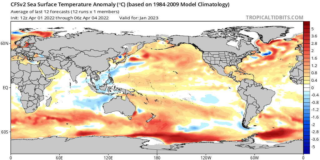
AlphaToOmega wrote:Category5Kaiju wrote:AlphaToOmega wrote:There is a chance 2022-2023 might be a +ENSO winter. A triple dip La Nina is not a sure thing.
https://i.postimg.cc/XYCbh1Rs/cfs-mon-01-ssta-global-9.png
Except if I recall correctly, that used to be glaringly +ENSO earlier this year (meaning the trend has been cooler over the past months or so)
There seems to be a trend towards a warmer ENSO for this winter:
https://i.postimg.cc/0QBfSnVw/cfs-mon-01-ssta-global-9.png
https://i.postimg.cc/d3Z9jCfS/cfs-mon-01-ssta-global-8.png
I wonder what could be causing this.
Oh, ok well I was thinking about the initilization dates in February and January and recall how the Cfv2 was predicting a much more potent +ENSO by the end of this year compared to now. I would caution though, there definitely could be something where the Cfv2 is trying to ever so slightly correct for its cold bias. Also, keep in mind that the initialization dates you just posted are relatively close to one another (end of March, very early April), so that alone is not statistically powerful and well indicative of how things will turn out later this year. Honestly, let's face it: there simply is not enough evidence and forcing that would favor an El Nino to form this year, and even +ENSO might be difficult to achieve given the lack of major, sustained WWBs over the Pacific so far. While I am not expecting any crazy low -ENSO this year, I certainly wouldn't expect an El Nino or, at least, bank on a +ENSO state from happening based on chance alone.
0 likes
Unless explicitly stated, all information in my posts is based on my own opinions and observations. Tropical storms and hurricanes can be extremely dangerous. Refer to an accredited weather research agency or meteorologist if you need to make serious decisions regarding an approaching storm.
-
dexterlabio
- Category 5
- Posts: 3517
- Joined: Sat Oct 24, 2009 11:50 pm
Re: 2022 indicators: SSTs / SAL / MSLP / shear / steering / instability / images
What is the longest streak that the ATL had been above-average? I believe the current streak is the longest (since 2016).
0 likes
Personal Forecast Disclaimer:
The posts in this forum are NOT official forecast and should not be used as such. They are just the opinion of the poster and may or may not be backed by sound meteorological data. They are NOT endorsed by any professional institution or storm2k.org. For official information, please refer to the NHC and NWS products.
The posts in this forum are NOT official forecast and should not be used as such. They are just the opinion of the poster and may or may not be backed by sound meteorological data. They are NOT endorsed by any professional institution or storm2k.org. For official information, please refer to the NHC and NWS products.
-
tolakram
- Admin
- Posts: 20186
- Age: 62
- Joined: Sun Aug 27, 2006 8:23 pm
- Location: Florence, KY (name is Mark)
Re: 2022 indicators: SSTs / SAL / MSLP / shear / steering / instability / images
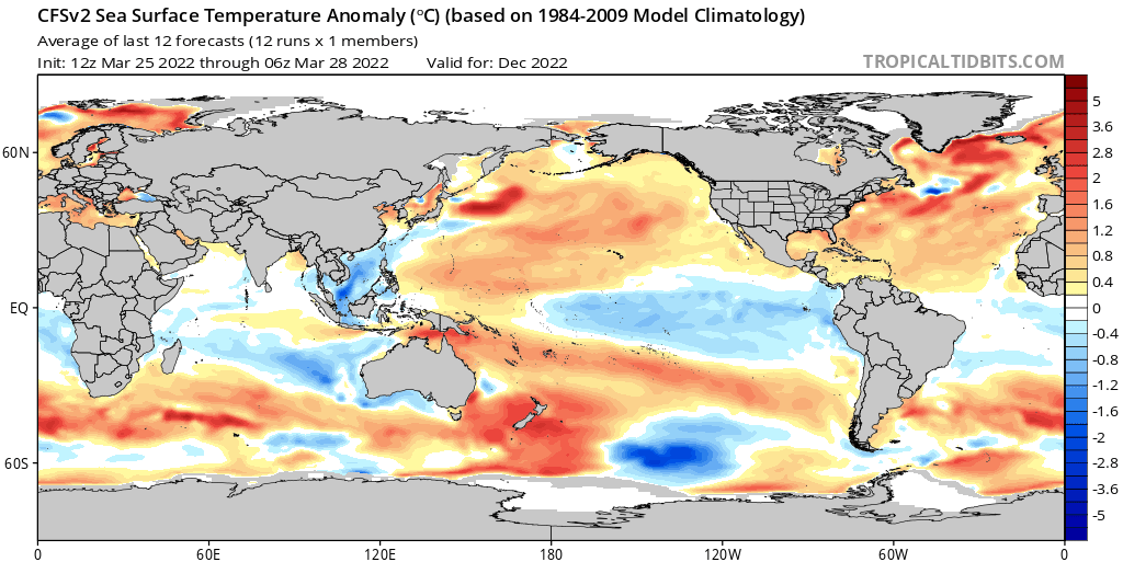
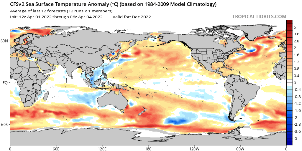
AlphaToOmega wrote:Category5Kaiju wrote:AlphaToOmega wrote:There is a chance 2022-2023 might be a +ENSO winter. A triple dip La Nina is not a sure thing.
https://i.postimg.cc/XYCbh1Rs/cfs-mon-01-ssta-global-9.png
Except if I recall correctly, that used to be glaringly +ENSO earlier this year (meaning the trend has been cooler over the past months or so)
There seems to be a trend towards a warmer ENSO for this winter:
https://i.postimg.cc/0QBfSnVw/cfs-mon-01-ssta-global-9.png
https://i.postimg.cc/d3Z9jCfS/cfs-mon-01-ssta-global-8.png
I wonder what could be causing this.
The spring barrier that makes seasonal forecasting prior to May so difficult. IMO.
0 likes
M a r k
- - - - -
Join us in chat: Storm2K Chatroom Invite. Android and IOS apps also available.
The posts in this forum are NOT official forecasts and should not be used as such. Posts are NOT endorsed by any professional institution or STORM2K.org. For official information and forecasts, please refer to NHC and NWS products.
-
Shell Mound
- Category 5
- Posts: 2432
- Age: 33
- Joined: Thu Sep 07, 2017 3:39 pm
- Location: St. Petersburg, FL → Scandinavia
Re: 2022 indicators: SSTs / SAL / MSLP / shear / steering / instability / images
cycloneye wrote:What you see in May and June related to the sst's in Eastern Atlantic will be the correlation to ACE for whole season.
https://twitter.com/philklotzbach/status/1511094894428782592
https://twitter.com/dmorris9661/status/1511124840627019784
On another note, the latest long-range EC seasonal outlook is indicating a seasonal ACE of ~175 through October 2022.
https://twitter.com/OSUWXGUY/status/1511322430857519106


Hyperactive ACE (>160) on the conservative EC + strong ridging matching composite of big FL hits + -ENSO/-PDO/-IOD ->

1 likes
CVW / MiamiensisWx / Shell Mound
The posts in this forum are NOT official forecasts and should not be used as such. They are just the opinion of the poster and may or may not be backed by sound meteorological data. They are NOT endorsed by any professional institution or STORM2K. For official information, please refer to products from the NHC and NWS.
-
Category5Kaiju
- Category 5
- Posts: 4345
- Joined: Thu Dec 24, 2020 12:45 pm
- Location: Seattle during the summer, Phoenix during the winter
Re: 2022 indicators: SSTs / SAL / MSLP / shear / steering / instability / images
Shell Mound wrote:cycloneye wrote:What you see in May and June related to the sst's in Eastern Atlantic will be the correlation to ACE for whole season.
https://twitter.com/philklotzbach/status/1511094894428782592
https://twitter.com/dmorris9661/status/1511124840627019784
On another note, the latest long-range EC seasonal outlook is indicating a seasonal ACE of ~175 through October 2022.
https://twitter.com/OSUWXGUY/status/1511322430857519106
https://i.ibb.co/mvm6MbW/Ska-rmavbild-2022-04-05-kl-15-43-57.png
https://i.ibb.co/z8GnBwb/FLhits.gif
Hyperactive ACE (>160) on the conservative EC + strong ridging matching composite of big FL hits + -ENSO/-PDO/-IOD ->
Yikes.
When Shell Mound gets concerned, that is a cue to be prepared.
0 likes
Unless explicitly stated, all information in my posts is based on my own opinions and observations. Tropical storms and hurricanes can be extremely dangerous. Refer to an accredited weather research agency or meteorologist if you need to make serious decisions regarding an approaching storm.
-
cycloneye
- Admin
- Posts: 149686
- Age: 69
- Joined: Thu Oct 10, 2002 10:54 am
- Location: San Juan, Puerto Rico
Re: 2022 indicators: SSTs / SAL / MSLP / shear / steering / instability / images
0 likes
Visit the Caribbean-Central America Weather Thread where you can find at first post web cams,radars
and observations from Caribbean basin members Click Here
and observations from Caribbean basin members Click Here
-
AutoPenalti
- Category 5
- Posts: 4091
- Age: 29
- Joined: Mon Aug 17, 2015 4:16 pm
- Location: Ft. Lauderdale, Florida
Re: 2022 indicators: SSTs / SAL / MSLP / shear / steering / instability / images
That could explain the slightly above average ACE numbers.
0 likes
The posts in this forum are NOT official forecasts and should not be used as such. They are just the opinion of the poster and may or may not be backed by sound meteorological data. They are NOT endorsed by any professional institution or STORM2K. For official information, please refer to products from the NHC and NWS.
Model Runs Cheat Sheet:
GFS (5:30 AM/PM, 11:30 AM/PM)
HWRF, GFDL, UKMET, NAVGEM (6:30-8:00 AM/PM, 12:30-2:00 AM/PM)
ECMWF (1:45 AM/PM)
TCVN is a weighted averaged
-
Shell Mound
- Category 5
- Posts: 2432
- Age: 33
- Joined: Thu Sep 07, 2017 3:39 pm
- Location: St. Petersburg, FL → Scandinavia
Re: 2022 indicators: SSTs / SAL / MSLP / shear / steering / instability / images
AutoPenalti wrote:That could explain the slightly above average ACE numbers.
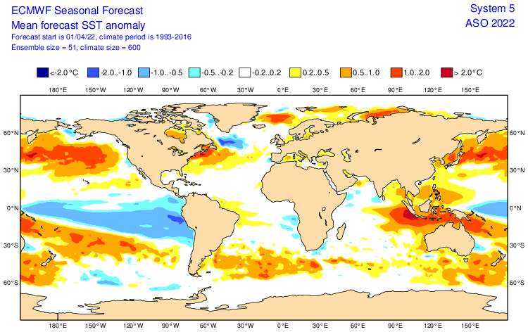
Actually, the raw EC data indicate that the modelled output suggests a hyperactive season. Seasonal ACE through October 2022 that is 30% higher than the mean of ~135 would equate to ~175, which is above the threshold (~160) for hyperactivity. For some reason the EC’s precipitation and SST fields do not always match the model’s raw output. Given that last season ended up featuring more CV-type long-trackers than 2020 did despite lower May–June SST in the MDR, 2022 will likely be at least as active as last year insofar as CV-type long-trackers are concerned. I would be surprised if we ended up with fewer than two long-trackers, all other factors being equal.
Comparison between MJ SST in the MDR in 2021 vs. 2020:

Despite featuring cooler SST during the aforementioned timeframe, 2021 eventually yielded the CV-type long-trackers Larry and Sam, whereas 2020 only featured Teddy. Also, note that 2022 to date has featured far more equatorial warmth east of South America than the previous season did. The Canary Current to date in 2022 has also been warmer than in either 2020 or 2021 at this time. There is more persistent warmth over the northern North Atlantic than in either of those two seasons to date. This suggests that 2022’s AMO is higher than some indices suggest, and that the potential is there for the equatorial warmth to migrate northward come ASO.

March 2022’s SSTs offshore of Greenland and Iceland were warmer than the mean of the past two Marches’.
0 likes
CVW / MiamiensisWx / Shell Mound
The posts in this forum are NOT official forecasts and should not be used as such. They are just the opinion of the poster and may or may not be backed by sound meteorological data. They are NOT endorsed by any professional institution or STORM2K. For official information, please refer to products from the NHC and NWS.
-
SFLcane

- S2K Supporter

- Posts: 10281
- Age: 48
- Joined: Sat Jun 05, 2010 1:44 pm
- Location: Lake Worth Florida
Re: 2022 indicators: SSTs / SAL / MSLP / shear / steering / instability / images
Were is that ACE coming from? Yikes to that Z500 prediction if it indeed came to pass.
0 likes
-
AlphaToOmega
- Category 5
- Posts: 1448
- Joined: Sat Jun 26, 2021 10:51 am
- Location: Somewhere in Massachusetts
Re: 2022 indicators: SSTs / SAL / MSLP / shear / steering / instability / images
Shell Mound wrote:cycloneye wrote:What you see in May and June related to the sst's in Eastern Atlantic will be the correlation to ACE for whole season.
https://twitter.com/philklotzbach/status/1511094894428782592
https://twitter.com/dmorris9661/status/1511124840627019784
On another note, the latest long-range EC seasonal outlook is indicating a seasonal ACE of ~175 through October 2022.
https://twitter.com/OSUWXGUY/status/1511322430857519106
https://i.ibb.co/mvm6MbW/Ska-rmavbild-2022-04-05-kl-15-43-57.png
https://i.ibb.co/z8GnBwb/FLhits.gif
Hyperactive ACE (>160) on the conservative EC + strong ridging matching composite of big FL hits + -ENSO/-PDO/-IOD ->
2021 did not achieve hyperactivity because of the Atlantic Nino, which suppressed ITCZ to the South. Without the Atlantic Nino, 2021 would have probably seen major hurricanes in October and/or November, brining it up to hyperactive levels. It only needed 17 more ACE to achieve that.
Also, a hyperactive season is not guaranteed. The ECMWF also forecasted an ACE 30% above the 1993-2016 mean for 2021, but that did not verify. This might or might not verify, but it is too early to tell.
Last edited by AlphaToOmega on Wed Apr 06, 2022 4:36 am, edited 2 times in total.
1 likes

Re: 2022 indicators: SSTs / SAL / MSLP / shear / steering / instability / images
I think we could see another 20+ NS, quantity-over-quality season with a lot of shorties in the subtropics. If the MDR ends up being too stable, we could have to worry about west-shifted activity like in 2020.
0 likes
Irene '11 Sandy '12 Hermine '16 5/15/2018 Derecho Fay '20 Isaias '20 Elsa '21 Henri '21 Ida '21
I am only a meteorology enthusiast who knows a decent amount about tropical cyclones. Look to the professional mets, the NHC, or your local weather office for the best information.
I am only a meteorology enthusiast who knows a decent amount about tropical cyclones. Look to the professional mets, the NHC, or your local weather office for the best information.

Re: 2022 indicators: SSTs / SAL / MSLP / shear / steering / instability / images
Shell Mound wrote:On another note, the latest long-range EC seasonal outlook is indicating a seasonal ACE of ~175 through October 2022.
I could be totally wrong on this, but wasn't the EC showing similarly high ACE last year at around this time, higher than past years including 2020? IIRC it was showing ~160, which didn't verify.
Of course it can just be an anomaly, but is it possible that Euro is now having a high bias in ACE, or correcting its low bias that was demonstrated earlier in this active streak?
(Feels so weird to be tampering down Shell Mound's expectations...)
0 likes
TC naming lists: retirements and intensity
Most aggressive Advisory #1's in North Atlantic (cr. kevin for starting the list)
Most aggressive Advisory #1's in North Atlantic (cr. kevin for starting the list)
-
AlphaToOmega
- Category 5
- Posts: 1448
- Joined: Sat Jun 26, 2021 10:51 am
- Location: Somewhere in Massachusetts
Re: 2022 indicators: SSTs / SAL / MSLP / shear / steering / instability / images
I would like to mention something few have mentioned: the Atlantic Nino/Nina.
For all of its faults (especially with AMM), the ECMWF does a pretty good job forecasting Atlantic Nino. It foresaw the Atlantic Nino of 2021 and the Atlantic Nada of 2020. I have ten current analogs for 2022, and they can be separated into two groups: Atlantic Nino and no Atlantic Nino.
I have always kept the Atlantic Nino as a tossup. However, with the new ECMWF monthly, I think I am ready to change that to leaning -AtlNino, meaning that an Atlantic Nina is favored for ASO this year.
What would this mean? This would mean that the ITCZ would not be suppressed to the south like it was in 2021. The Coriolis Force would not be an issue, and the Caribbean development would actually be possible (unlike in 2021). Of course, this could change, but the Gulf of Guinea is shaping up to be cooler than last year.
For all of its faults (especially with AMM), the ECMWF does a pretty good job forecasting Atlantic Nino. It foresaw the Atlantic Nino of 2021 and the Atlantic Nada of 2020. I have ten current analogs for 2022, and they can be separated into two groups: Atlantic Nino and no Atlantic Nino.
- +AtlNino: 1999, 2007, 2008, and 2021
- -AtlNino: 1998, 2001, 2005, 2010, 2011, and 2020
I have always kept the Atlantic Nino as a tossup. However, with the new ECMWF monthly, I think I am ready to change that to leaning -AtlNino, meaning that an Atlantic Nina is favored for ASO this year.
What would this mean? This would mean that the ITCZ would not be suppressed to the south like it was in 2021. The Coriolis Force would not be an issue, and the Caribbean development would actually be possible (unlike in 2021). Of course, this could change, but the Gulf of Guinea is shaping up to be cooler than last year.
0 likes
-
Category5Kaiju
- Category 5
- Posts: 4345
- Joined: Thu Dec 24, 2020 12:45 pm
- Location: Seattle during the summer, Phoenix during the winter
Re: 2022 indicators: SSTs / SAL / MSLP / shear / steering / instability / images
AlphaToOmega wrote:I would like to mention something few have mentioned: the Atlantic Nino/Nina.
For all of its faults (especially with AMM), the ECMWF does a pretty good job forecasting Atlantic Nino. It foresaw the Atlantic Nino of 2021 and the Atlantic Nada of 2020. I have ten current analogs for 2022, and they can be separated into two groups: Atlantic Nino and no Atlantic Nino.
- +AtlNino: 1999, 2007, 2008, and 2021
- -AtlNino: 1998, 2001, 2005, 2010, 2011, and 2020
I have always kept the Atlantic Nino as a tossup. However, with the new ECMWF monthly, I think I am ready to change that to leaning -AtlNino, meaning that an Atlantic Nina is favored for ASO this year.
https://i.postimg.cc/XqjWxNsM/ps2png-worker-commands-68f4c845bf-7hxpt-6fe5cac1a363ec1525f54343b6cc9fd8-NGuf6i.png
What would this mean? This would mean that the ITCZ would not be suppressed to the south like it was in 2021. The Coriolis Force would not be an issue, and the Caribbean development would actually be possible (unlike in 2021). Of course, this could change, but the Gulf of Guinea is shaping up to be cooler than last year.
The Atlantic Nino last year was just phenomenal. It was so intense that the otherwise poorly studied phenomenon started grabbing the attention of many weather-goers, and I honestly think that had that not happened last year, "Atlantic Nino" would still be a relatively elusive term in the wx community. But yes, I do agree that this year will likely not feature such a powerful Atlantic Nino, the chances of that happening just do not seem to be there.
3 likes
Unless explicitly stated, all information in my posts is based on my own opinions and observations. Tropical storms and hurricanes can be extremely dangerous. Refer to an accredited weather research agency or meteorologist if you need to make serious decisions regarding an approaching storm.
-
NotSparta

- Professional-Met

- Posts: 1677
- Age: 24
- Joined: Fri Aug 18, 2017 8:24 am
- Location: Naples, FL
- Contact:
Re: 2022 indicators: SSTs / SAL / MSLP / shear / steering / instability / images
AlphaToOmega wrote:Category5Kaiju wrote:AlphaToOmega wrote:There is a chance 2022-2023 might be a +ENSO winter. A triple dip La Nina is not a sure thing.
https://i.postimg.cc/XYCbh1Rs/cfs-mon-01-ssta-global-9.png
Except if I recall correctly, that used to be glaringly +ENSO earlier this year (meaning the trend has been cooler over the past months or so)
There seems to be a trend towards a warmer ENSO for this winter:
https://i.postimg.cc/0QBfSnVw/cfs-mon-01-ssta-global-9.png
https://i.postimg.cc/d3Z9jCfS/cfs-mon-01-ssta-global-8.png
I wonder what could be causing this.
Might just be the change in month from March to April, for some reason that messes with the CFS SST forecasts
1 likes
This post was probably an opinion of mine, and in no way is official. Please refer to http://www.hurricanes.gov for official tropical analysis and advisories.
My website, with lots of tropical wx graphics, including satellite and recon: http://cyclonicwx.com
My website, with lots of tropical wx graphics, including satellite and recon: http://cyclonicwx.com
-
Shell Mound
- Category 5
- Posts: 2432
- Age: 33
- Joined: Thu Sep 07, 2017 3:39 pm
- Location: St. Petersburg, FL → Scandinavia
Re: 2022 indicators: SSTs / SAL / MSLP / shear / steering / instability / images
aspen wrote:
I think we could see another 20+ NS, quantity-over-quality season with a lot of shorties in the subtropics. If the MDR ends up being too stable, we could have to worry about west-shifted activity like in 2020.
Not so fast:
https://twitter.com/dmorris9661/status/1511402424354889733
You will also need to explain how 2021 ended up with a more intense CV system than 2020 did despite featuring cooler SSTs in the MDR.
Teban54 wrote:Shell Mound wrote:On another note, the latest long-range EC seasonal outlook is indicating a seasonal ACE of ~175 through October 2022.
I could be totally wrong on this, but wasn't the EC showing similarly high ACE last year at around this time, higher than past years including 2020? IIRC it was showing ~160, which didn't verify.
Of course it can just be an anomaly, but is it possible that Euro is now having a high bias in ACE, or correcting its low bias that was demonstrated earlier in this active streak?
(Feels so weird to be tampering down Shell Mound's expectations...)

Actually, the EC’s forecast ACE for 2021 ended up slightly below the observed total, but was otherwise almost exactly right.
As can be seen in the graphic above, ACE totals for every season since 2016 have been at least slightly underestimated.
Finally, the graphic also indicates that the forecast for ‘22 actually anticipates slightly higher ACE than was forecast for ‘21.
1 likes
CVW / MiamiensisWx / Shell Mound
The posts in this forum are NOT official forecasts and should not be used as such. They are just the opinion of the poster and may or may not be backed by sound meteorological data. They are NOT endorsed by any professional institution or STORM2K. For official information, please refer to products from the NHC and NWS.
Re: 2022 indicators: SSTs / SAL / MSLP / shear / steering / instability / images
Shell Mound wrote:Teban54 wrote:Shell Mound wrote:On another note, the latest long-range EC seasonal outlook is indicating a seasonal ACE of ~175 through October 2022.
I could be totally wrong on this, but wasn't the EC showing similarly high ACE last year at around this time, higher than past years including 2020? IIRC it was showing ~160, which didn't verify.
Of course it can just be an anomaly, but is it possible that Euro is now having a high bias in ACE, or correcting its low bias that was demonstrated earlier in this active streak?
(Feels so weird to be tampering down Shell Mound's expectations...)
https://i.ibb.co/FhTnNXj/Ska-rmavbild-2022-04-06-kl-09-13-44.png
Actually, the EC’s forecast ACE for 2021 ended up slightly below the observed total, but was otherwise almost exactly right.
As can be seen in the graphic above, ACE totals for every season since 2016 have been at least slightly underestimated.
Finally, the graphic also indicates that the forecast for ‘22 actually anticipates slightly higher ACE than was forecast for ‘21.
Thanks for the plot! Seems like EC's ACE forecasts are generally underestimates in active years, and overestimates in average or below-average years. (Except 2007, 2008 and 2021, but 2007 was an oddball in itself.) So that would mean it has relatively little skill after all...?
I'm also not sure if the historical data from many years back is useful. Their models have probably been updated many times over the decades. If we only consider the recent active streak, then yes, the trend of underestimations is clear (mayyybe except 2021).
But leaving aside the concerns of validity, it's interesting that the ACE forecast for 2022 is similar to 2000, which ended up below expectations and which was a 3rd year La Nina.
3 likes
TC naming lists: retirements and intensity
Most aggressive Advisory #1's in North Atlantic (cr. kevin for starting the list)
Most aggressive Advisory #1's in North Atlantic (cr. kevin for starting the list)
-
AlphaToOmega
- Category 5
- Posts: 1448
- Joined: Sat Jun 26, 2021 10:51 am
- Location: Somewhere in Massachusetts
Re: 2022 indicators: SSTs / SAL / MSLP / shear / steering / instability / images
Teban54 wrote:Shell Mound wrote:Teban54 wrote:I could be totally wrong on this, but wasn't the EC showing similarly high ACE last year at around this time, higher than past years including 2020? IIRC it was showing ~160, which didn't verify.
Of course it can just be an anomaly, but is it possible that Euro is now having a high bias in ACE, or correcting its low bias that was demonstrated earlier in this active streak?
(Feels so weird to be tampering down Shell Mound's expectations...)
https://i.ibb.co/FhTnNXj/Ska-rmavbild-2022-04-06-kl-09-13-44.png
Actually, the EC’s forecast ACE for 2021 ended up slightly below the observed total, but was otherwise almost exactly right.
As can be seen in the graphic above, ACE totals for every season since 2016 have been at least slightly underestimated.
Finally, the graphic also indicates that the forecast for ‘22 actually anticipates slightly higher ACE than was forecast for ‘21.
Thanks for the plot! Seems like EC's ACE forecasts are generally underestimates in active years, and overestimates in average or below-average years. (Except 2007, 2008 and 2021, but 2007 was an oddball in itself.) So that would mean it has relatively little skill after all...?
I'm also not sure if the historical data from many years back is useful. Their models have probably been updated many times over the decades. If we only consider the recent active streak, then yes, the trend of underestimations is clear (mayyybe except 2021).
But leaving aside the concerns of validity, it's interesting that the ACE forecast for 2022 is similar to 2000, which ended up below expectations and which was a 3rd year La Nina.
That graphic is for MJJASO; hurricane season is JJASON.
0 likes
-
Shell Mound
- Category 5
- Posts: 2432
- Age: 33
- Joined: Thu Sep 07, 2017 3:39 pm
- Location: St. Petersburg, FL → Scandinavia
Re: 2022 indicators: SSTs / SAL / MSLP / shear / steering / instability / images
Here is an interesting question to ponder: why did 2021 feature a more intense CV season than 2020 did? 2021 featured cooler SSTs in the MDR during May–June than 2020 did, which correlates with lower seasonal ACE in the deep tropics, yet 2020 only featured one CV-type, long-lived major hurricane, Teddy, while 2021 featured two such systems, Larry and Sam. I see that some people here are expecting an inactive MDR and relatively low seasonal ACE combined with short-lived systems in the subtropics. Yet one would have expected 2021 to have been less active than 2020 in the MDR, yet the opposite proved to be the case. Moreover, 2021 featured the notorious Atlantic Niño, which should have suppressed the MDR to a greater degree than in 2020, yet 2021 featured the largest number of major hurricanes in the MDR (two) since 2017 (three). My point is this: given that 2022 will likely not feature a robust Atlantic Niño and is already featuring warmer SSTs in key regions (the Canaries, off Greenland, etc.) than 2021 did at this time, why would 2022 feature fewer strong hurricanes in the MDR than last year? After all, both 2020 and 2005 featured warmer SSTs in the MDR during May–June than 2021 did, yet ended up with fewer major hurricanes in that region.
0 likes
CVW / MiamiensisWx / Shell Mound
The posts in this forum are NOT official forecasts and should not be used as such. They are just the opinion of the poster and may or may not be backed by sound meteorological data. They are NOT endorsed by any professional institution or STORM2K. For official information, please refer to products from the NHC and NWS.
Who is online
Users browsing this forum: No registered users and 225 guests