2022 Indicators (SSTs/SAL/MSLP/Shear/Steering/Instability) and >Day 16 Models

This is the general tropical discussion area. Anyone can take their shot at predicting a storms path.

Moderator: S2k Moderators

Forum rules

The posts in this forum are NOT official forecasts and should not be used as such. They are just the opinion of the poster and may or may not be backed by sound meteorological data. They are NOT endorsed by any professional institution or STORM2K. For official information, please refer to products from the National Hurricane Center and National Weather Service.

Help Support Storm2K
Message
Author
AlphaToOmega
Category 5
Category 5
Posts: 1448
Joined: Sat Jun 26, 2021 10:51 am
Location: Somewhere in Massachusetts

Re: 2022 indicators: SSTs / SAL / MSLP / shear / steering / instability / images

#301 Postby AlphaToOmega » Thu Apr 07, 2022 4:52 am

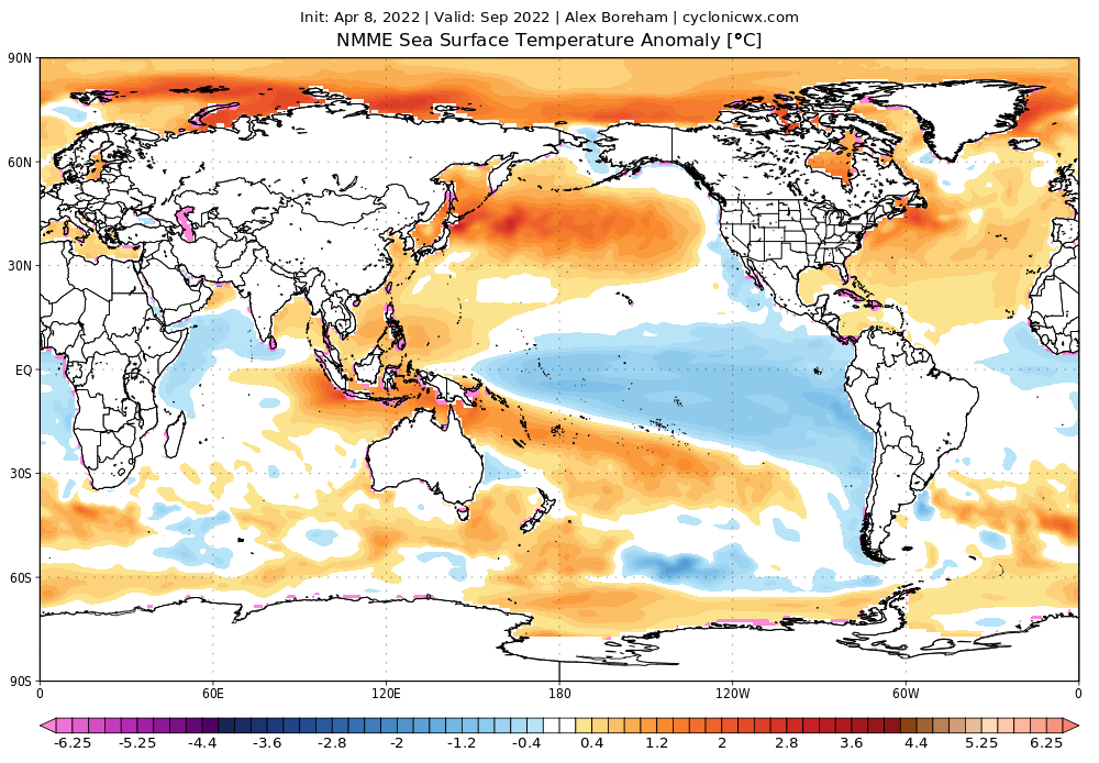
Shell Mound wrote:Here is an interesting question to ponder: why did 2021 feature a more intense CV season than 2020 did? 2021 featured cooler SSTs in the MDR during May–June than 2020 did, which correlates with lower seasonal ACE in the deep tropics, yet 2020 only featured one CV-type, long-lived major hurricane, Teddy, while 2021 featured two such systems, Larry and Sam. I see that some people here are expecting an inactive MDR and relatively low seasonal ACE combined with short-lived systems in the subtropics. Yet one would have expected 2021 to have been less active than 2020 in the MDR, yet the opposite proved to be the case. Moreover, 2021 featured the notorious Atlantic Niño, which should have suppressed the MDR to a greater degree than in 2020, yet 2021 featured the largest number of major hurricanes in the MDR (two) since 2017 (three). My point is this: given that 2022 will likely not feature a robust Atlantic Niño and is already featuring warmer SSTs in key regions (the Canaries, off Greenland, etc.) than 2021 did at this time, why would 2022 feature fewer strong hurricanes in the MDR than last year? After all, both 2020 and 2005 featured warmer SSTs in the MDR during May–June than 2021 did, yet ended up with fewer major hurricanes in that region.


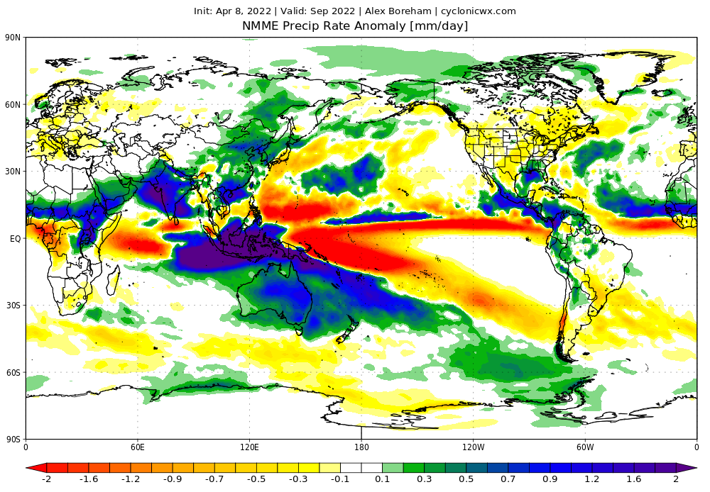
The Atlantic Nino pushed the ITCZ southward in 2021, causing tropical waves to develop in warmer seas in the MDR, making 2021 more MDR-based. However, near the end of the season, the southern ITCZ caused Caribbean development to become impossible despite seemingly favorable conditions in the Caribbean.
1 likes   

Shell Mound
Category 5
Category 5
Posts: 2434
Age: 32
Joined: Thu Sep 07, 2017 3:39 pm
Location: St. Petersburg, FL → Scandinavia

Re: 2022 indicators: SSTs / SAL / MSLP / shear / steering / instability / images

#302 Postby Shell Mound » Thu Apr 07, 2022 10:45 am

1 likes   
CVW / MiamiensisWx / Shell Mound
The posts in this forum are NOT official forecasts and should not be used as such. They are just the opinion of the poster and may or may not be backed by sound meteorological data. They are NOT endorsed by any professional institution or STORM2K. For official information, please refer to products from the NHC and NWS.

User avatar
Teban54
Category 5
Category 5
Posts: 3168
Joined: Sat May 19, 2018 1:19 pm

Re: 2022 indicators: SSTs / SAL / MSLP / shear / steering / instability / images

#303 Postby Teban54 » Thu Apr 07, 2022 11:24 am


Interesting that warm subtropics in March actually correlates with above-average activity, instead of below-average that you might expect. Though I do wonder if that's partially a result of the rather persistent subtropical warm pool during the recent active streak skewing the data.
1 likes   

AlphaToOmega
Category 5
Category 5
Posts: 1448
Joined: Sat Jun 26, 2021 10:51 am
Location: Somewhere in Massachusetts

Re: 2022 indicators: SSTs / SAL / MSLP / shear / steering / instability / images

#304 Postby AlphaToOmega » Thu Apr 07, 2022 11:30 am

The April NMME forecast has been released. The things to note are the +AMO, the +AMM, the -PDO, the La Nina, the Atlantic Nina, the -IOD (which is really a result of the -ENSO/-PDO pattern), and the strong WAM. Climate models have been typically biased towards a more negative AMM for the past couple of years, so to see this model forecast a +AMM is certainly intriguing.

Image
Image

While the CFSv2 might forecast ENSO-neutral conditions for this winter, the NMME ensemble still forecasts solid -ENSO for the 2022-2023 winter.

Image
3 likes   

User avatar
SFLcane
S2K Supporter
S2K Supporter
Posts: 10162
Age: 47
Joined: Sat Jun 05, 2010 1:44 pm
Location: Lake Worth Florida

Re: 2022 indicators: SSTs / SAL / MSLP / shear / steering / instability / images

#305 Postby SFLcane » Thu Apr 07, 2022 12:57 pm

AlphaToOmega wrote:The April NMME forecast has been released. The things to note are the +AMO, the +AMM, the -PDO, the La Nina, the Atlantic Nina, the -IOD (which is really a result of the -ENSO/-PDO pattern), and the strong WAM. Climate models have been typically biased towards a more negative AMM for the past couple of years, so to see this model forecast a +AMM is certainly intriguing.

https://i.postimg.cc/R0rnvV0y/nmme-global-pratea-2022040800-f005.png
https://i.postimg.cc/vZxVR6G5/nmme-global-ssta-2022040800-f005.png

While the CFSv2 might forecast ENSO-neutral conditions for this winter, the NMME ensemble still forecasts solid -ENSO for the 2022-2023 winter.

https://i.postimg.cc/sgnsJTkc/nmme-global-ssta-2022040800-f008.png


Looks like a quick recurve pattern based on those precip anomalies. Other factors involved as usual
0 likes   

AutoPenalti
Category 5
Category 5
Posts: 4029
Age: 28
Joined: Mon Aug 17, 2015 4:16 pm
Location: Ft. Lauderdale, Florida

Re: 2022 indicators: SSTs / SAL / MSLP / shear / steering / instability / images

#306 Postby AutoPenalti » Thu Apr 07, 2022 1:16 pm

SFLcane wrote:
AlphaToOmega wrote:The April NMME forecast has been released. The things to note are the +AMO, the +AMM, the -PDO, the La Nina, the Atlantic Nina, the -IOD (which is really a result of the -ENSO/-PDO pattern), and the strong WAM. Climate models have been typically biased towards a more negative AMM for the past couple of years, so to see this model forecast a +AMM is certainly intriguing.

https://i.postimg.cc/R0rnvV0y/nmme-global-pratea-2022040800-f005.png
https://i.postimg.cc/vZxVR6G5/nmme-global-ssta-2022040800-f005.png

While the CFSv2 might forecast ENSO-neutral conditions for this winter, the NMME ensemble still forecasts solid -ENSO for the 2022-2023 winter.

https://i.postimg.cc/sgnsJTkc/nmme-global-ssta-2022040800-f008.png


Looks like a quick recurve pattern based on those precip anomalies. Other factors involved as usual

or unfavorable conditions past the MDR
1 likes   
The posts in this forum are NOT official forecasts and should not be used as such. They are just the opinion of the poster and may or may not be backed by sound meteorological data. They are NOT endorsed by any professional institution or STORM2K. For official information, please refer to products from the NHC and NWS.


Model Runs Cheat Sheet:
GFS (5:30 AM/PM, 11:30 AM/PM)
HWRF, GFDL, UKMET, NAVGEM (6:30-8:00 AM/PM, 12:30-2:00 AM/PM)
ECMWF (1:45 AM/PM)

TCVN
is a weighted averaged

AutoPenalti
Category 5
Category 5
Posts: 4029
Age: 28
Joined: Mon Aug 17, 2015 4:16 pm
Location: Ft. Lauderdale, Florida

Re: 2022 indicators: SSTs / SAL / MSLP / shear / steering / instability / images

#307 Postby AutoPenalti » Thu Apr 07, 2022 1:23 pm

AlphaToOmega wrote:The April NMME forecast has been released. The things to note are the +AMO, the +AMM, the -PDO, the La Nina, the Atlantic Nina, the -IOD (which is really a result of the -ENSO/-PDO pattern), and the strong WAM. Climate models have been typically biased towards a more negative AMM for the past couple of years, so to see this model forecast a +AMM is certainly intriguing.

https://i.postimg.cc/R0rnvV0y/nmme-global-pratea-2022040800-f005.png
https://i.postimg.cc/vZxVR6G5/nmme-global-ssta-2022040800-f005.png

While the CFSv2 might forecast ENSO-neutral conditions for this winter, the NMME ensemble still forecasts solid -ENSO for the 2022-2023 winter.

https://i.postimg.cc/sgnsJTkc/nmme-global-ssta-2022040800-f008.png

Looks sort of similar to 2020 in terms of it being +AMO, -ENSO and +AMM and Atlantic Nina, and the possibility of a strong WAM.
0 likes   
The posts in this forum are NOT official forecasts and should not be used as such. They are just the opinion of the poster and may or may not be backed by sound meteorological data. They are NOT endorsed by any professional institution or STORM2K. For official information, please refer to products from the NHC and NWS.


Model Runs Cheat Sheet:
GFS (5:30 AM/PM, 11:30 AM/PM)
HWRF, GFDL, UKMET, NAVGEM (6:30-8:00 AM/PM, 12:30-2:00 AM/PM)
ECMWF (1:45 AM/PM)

TCVN
is a weighted averaged

User avatar
SFLcane
S2K Supporter
S2K Supporter
Posts: 10162
Age: 47
Joined: Sat Jun 05, 2010 1:44 pm
Location: Lake Worth Florida

Re: 2022 indicators: SSTs / SAL / MSLP / shear / steering / instability / images

#308 Postby SFLcane » Thu Apr 07, 2022 1:24 pm

SFLcane wrote:
AlphaToOmega wrote:The April NMME forecast has been released. The things to note are the +AMO, the +AMM, the -PDO, the La Nina, the Atlantic Nina, the -IOD (which is really a result of the -ENSO/-PDO pattern), and the strong WAM. Climate models have been typically biased towards a more negative AMM for the past couple of years, so to see this model forecast a +AMM is certainly intriguing.

https://i.postimg.cc/R0rnvV0y/nmme-global-pratea-2022040800-f005.png
https://i.postimg.cc/vZxVR6G5/nmme-global-ssta-2022040800-f005.png

While the CFSv2 might forecast ENSO-neutral conditions for this winter, the NMME ensemble still forecasts solid -ENSO for the 2022-2023 winter.

https://i.postimg.cc/sgnsJTkc/nmme-global-ssta-2022040800-f008.png


Looks like a quick recurve pattern based on those precip anomalies. Other factors involved as usual


Another active season like 2010 with most storms recurving out to sea.
0 likes   

User avatar
cycloneye
Admin
Admin
Posts: 143867
Age: 68
Joined: Thu Oct 10, 2002 10:54 am
Location: San Juan, Puerto Rico

Re: 2022 indicators: SSTs / SAL / MSLP / shear / steering / instability / images

#309 Postby cycloneye » Thu Apr 07, 2022 1:55 pm

Hopefully, the recurve pattern establishes but I will always prepare here in PR and I am sure our friends in the islands for the worse and hoping for the best case scenario.
4 likes   
Visit the Caribbean-Central America Weather Thread where you can find at first post web cams,radars
and observations from Caribbean basin members Click Here

User avatar
cycloneye
Admin
Admin
Posts: 143867
Age: 68
Joined: Thu Oct 10, 2002 10:54 am
Location: San Juan, Puerto Rico

Re: 2022 indicators: SSTs / SAL / MSLP / shear / steering / instability / images

#310 Postby cycloneye » Thu Apr 07, 2022 2:52 pm

Analog years from CSU.

Image
1 likes   
Visit the Caribbean-Central America Weather Thread where you can find at first post web cams,radars
and observations from Caribbean basin members Click Here

User avatar
aspen
Category 5
Category 5
Posts: 8812
Joined: Sat Oct 12, 2019 7:10 pm
Location: Connecticut, USA

Re: 2022 indicators: SSTs / SAL / MSLP / shear / steering / instability / images

#311 Postby aspen » Thu Apr 07, 2022 4:31 pm

AutoPenalti wrote:
SFLcane wrote:
AlphaToOmega wrote:The April NMME forecast has been released. The things to note are the +AMO, the +AMM, the -PDO, the La Nina, the Atlantic Nina, the -IOD (which is really a result of the -ENSO/-PDO pattern), and the strong WAM. Climate models have been typically biased towards a more negative AMM for the past couple of years, so to see this model forecast a +AMM is certainly intriguing.

https://i.postimg.cc/R0rnvV0y/nmme-global-pratea-2022040800-f005.png
https://i.postimg.cc/vZxVR6G5/nmme-global-ssta-2022040800-f005.png

While the CFSv2 might forecast ENSO-neutral conditions for this winter, the NMME ensemble still forecasts solid -ENSO for the 2022-2023 winter.

https://i.postimg.cc/sgnsJTkc/nmme-global-ssta-2022040800-f008.png


Looks like a quick recurve pattern based on those precip anomalies. Other factors involved as usual

or unfavorable conditions past the MDR

It looks pretty decent in the western Atlantic. The above-normal precip for the Gulf would be very concerning if it verifies. However, the eastern Caribbean looks pretty dry and maybe could end up being pretty hostile like in 2018/19.

A season dominated with strong fish storms like 2010 would be a nice change of pace from the last few years of monsters blowing up right next to land.
0 likes   
Irene '11 Sandy '12 Hermine '16 5/15/2018 Derecho Fay '20 Isaias '20 Elsa '21 Henri '21 Ida '21

I am only a meteorology enthusiast who knows a decent amount about tropical cyclones. Look to the professional mets, the NHC, or your local weather office for the best information.

User avatar
DorkyMcDorkface
Category 3
Category 3
Posts: 820
Age: 27
Joined: Mon Sep 30, 2019 1:32 pm
Location: Mid-Atlantic

Re: 2022 indicators: SSTs / SAL / MSLP / shear / steering / instability / images

#312 Postby DorkyMcDorkface » Thu Apr 07, 2022 4:58 pm

2 likes   
Please note the thougths expressed by this account are solely those of the user and are from a hobbyist perspective. For more comprehensive analysis, consult an actual professional meteorologist or meteorology agency.


Floyd 1999 | Isabel 2003 | Hanna 2008 | Irene 2011 | Sandy 2012 | Isaias 2020

User avatar
NotSparta
Professional-Met
Professional-Met
Posts: 1668
Age: 23
Joined: Fri Aug 18, 2017 8:24 am
Location: Naples, FL
Contact:

Re: 2022 indicators: SSTs / SAL / MSLP / shear / steering / instability / images

#313 Postby NotSparta » Thu Apr 07, 2022 9:32 pm

SFLcane wrote:
AlphaToOmega wrote:The April NMME forecast has been released. The things to note are the +AMO, the +AMM, the -PDO, the La Nina, the Atlantic Nina, the -IOD (which is really a result of the -ENSO/-PDO pattern), and the strong WAM. Climate models have been typically biased towards a more negative AMM for the past couple of years, so to see this model forecast a +AMM is certainly intriguing.

https://i.postimg.cc/R0rnvV0y/nmme-global-pratea-2022040800-f005.png
https://i.postimg.cc/vZxVR6G5/nmme-global-ssta-2022040800-f005.png

While the CFSv2 might forecast ENSO-neutral conditions for this winter, the NMME ensemble still forecasts solid -ENSO for the 2022-2023 winter.

https://i.postimg.cc/sgnsJTkc/nmme-global-ssta-2022040800-f008.png


Looks like a quick recurve pattern based on those precip anomalies. Other factors involved as usual


I'd caution against using these maps to guage steering patterns. All you need is a brief disruption in a pattern for a storm or two to get caught in. Climate models like this can't catch that. It'd be nice if everything recurved but it's no guarantee
7 likes   
This post was probably an opinion of mine, and in no way is official. Please refer to http://www.hurricanes.gov for official tropical analysis and advisories.

My website, with lots of tropical wx graphics, including satellite and recon: http://cyclonicwx.com

User avatar
Category5Kaiju
Category 5
Category 5
Posts: 4051
Joined: Thu Dec 24, 2020 12:45 pm
Location: Seattle

Re: 2022 indicators: SSTs / SAL / MSLP / shear / steering / instability / images

#314 Postby Category5Kaiju » Thu Apr 07, 2022 10:10 pm

NotSparta wrote:
SFLcane wrote:
AlphaToOmega wrote:The April NMME forecast has been released. The things to note are the +AMO, the +AMM, the -PDO, the La Nina, the Atlantic Nina, the -IOD (which is really a result of the -ENSO/-PDO pattern), and the strong WAM. Climate models have been typically biased towards a more negative AMM for the past couple of years, so to see this model forecast a +AMM is certainly intriguing.

https://i.postimg.cc/R0rnvV0y/nmme-global-pratea-2022040800-f005.png
https://i.postimg.cc/vZxVR6G5/nmme-global-ssta-2022040800-f005.png

While the CFSv2 might forecast ENSO-neutral conditions for this winter, the NMME ensemble still forecasts solid -ENSO for the 2022-2023 winter.

https://i.postimg.cc/sgnsJTkc/nmme-global-ssta-2022040800-f008.png


Looks like a quick recurve pattern based on those precip anomalies. Other factors involved as usual


I'd caution against using these maps to guage steering patterns. All you need is a brief disruption in a pattern for a storm or two to get caught in. Climate models like this can't catch that. It'd be nice if everything recurved but it's no guarantee


Precisely. Also, how accurate were such maps in predicting the tracks of storms in years from 2016-2021? I can't imagine this being a tell-all, crystal ball for what to expect?
1 likes   
Unless explicitly stated, all info in my posts is based on my own opinions and observations. Tropical storms and hurricanes can be extremely dangerous. Do not think you can beat Mother Nature. Refer to an accredited weather research agency or meteorologist if you need to make serious decisions regarding an approaching storm.

Shell Mound
Category 5
Category 5
Posts: 2434
Age: 32
Joined: Thu Sep 07, 2017 3:39 pm
Location: St. Petersburg, FL → Scandinavia

Re: 2022 indicators: SSTs / SAL / MSLP / shear / steering / instability / images

#315 Postby Shell Mound » Fri Apr 08, 2022 6:15 am

Category5Kaiju wrote:
NotSparta wrote:
SFLcane wrote:
Looks like a quick recurve pattern based on those precip anomalies. Other factors involved as usual


I'd caution against using these maps to guage steering patterns. All you need is a brief disruption in a pattern for a storm or two to get caught in. Climate models like this can't catch that. It'd be nice if everything recurved but it's no guarantee

Precisely. Also, how accurate were such maps in predicting the tracks of storms in years from 2016-2021? I can't imagine this being a tell-all, crystal ball for what to expect?

Image
Image
Image
Image
Image
Image
Image
Image
Image
Image

Based on the past five April outlooks for ASO, the placement of anomalies seems to have been rather accurate. The only qualification is that 2020 and ‘21 ended up drier than was initially forecast across much of the MDR and/or Caribbean. Nevertheless, these long-range forecasts do seem to be useful in terms of gauging general steering patterns. My guess is that the latest April NMME is probably overestimating precipitation over the MDR and underestimating the influence of the subtropical warm pool, but otherwise likely has a decent grasp of the eventual steering currents. Four out of the five past several seasons have been consistently dry over peninsular Florida and wet over the northwestern Gulf Coast (especially Texas/Louisiana). The latest April NMME seems to be déjà vu: dry over peninsular Florida, wet over the northwestern Gulf:

Image

It seems as though Texas and Louisiana just can’t catch a break... :cry:
0 likes   
CVW / MiamiensisWx / Shell Mound
The posts in this forum are NOT official forecasts and should not be used as such. They are just the opinion of the poster and may or may not be backed by sound meteorological data. They are NOT endorsed by any professional institution or STORM2K. For official information, please refer to products from the NHC and NWS.

tolakram
Admin
Admin
Posts: 19990
Age: 61
Joined: Sun Aug 27, 2006 8:23 pm
Location: Florence, KY (name is Mark)

Re: 2022 indicators: SSTs / SAL / MSLP / shear / steering / instability / images

#316 Postby tolakram » Fri Apr 08, 2022 9:15 am

Shell Mound wrote:
Based on the past five April outlooks for ASO, the placement of anomalies seems to have been rather accurate. The only qualification is that 2020 and ‘21 ended up drier than was initially forecast across much of the MDR and/or Caribbean. Nevertheless, these long-range forecasts do seem to be useful in terms of gauging general steering patterns. My guess is that the latest April NMME is probably overestimating precipitation over the MDR and underestimating the influence of the subtropical warm pool, but otherwise likely has a decent grasp of the eventual steering currents. Four out of the five past several seasons have been consistently dry over peninsular Florida and wet over the northwestern Gulf Coast (especially Texas/Louisiana). The latest April NMME seems to be déjà vu: dry over peninsular Florida, wet over the northwestern Gulf:


I'm not sure why you think 2020 was usable. What are you seeing that I'm not. Green/yellow is drier, blue is wetter.

Image

2020 storm tracks
Image
1 likes   
M a r k
- - - - -
Join us in chat: Storm2K Chatroom Invite. Android and IOS apps also available.

The posts in this forum are NOT official forecasts and should not be used as such. Posts are NOT endorsed by any professional institution or STORM2K.org. For official information and forecasts, please refer to NHC and NWS products.

User avatar
Iceresistance
Category 5
Category 5
Posts: 9279
Age: 21
Joined: Sat Oct 10, 2020 9:45 am
Location: Tecumseh, OK/Norman, OK

Re: 2022 indicators: SSTs / SAL / MSLP / shear / steering / instability / images

#317 Postby Iceresistance » Fri Apr 08, 2022 9:38 am

0 likes   
Bill 2015 & Beta 2020

Winter 2020-2021 :cold:

All observations are in Tecumseh, OK unless otherwise noted.

Winter posts are focused mainly for Oklahoma & Texas.

Take any of my forecasts with a grain of salt, refer to the NWS, SPC, and NHC for official information

Never say Never with weather! Because ANYTHING is possible!

User avatar
Category5Kaiju
Category 5
Category 5
Posts: 4051
Joined: Thu Dec 24, 2020 12:45 pm
Location: Seattle

Re: 2022 indicators: SSTs / SAL / MSLP / shear / steering / instability / images

#318 Postby Category5Kaiju » Fri Apr 08, 2022 11:42 am


So I noticed how Ben said that Atlantic Ninos can enhance activity in his tweets, but based on what we saw last year, wouldn't it be appropriate to conclude that strong Atlantic Ninos can only help a season so much (and then if it lasts too long rob the MDR or higher latitudes of being able to feature storms?)
0 likes   
Unless explicitly stated, all info in my posts is based on my own opinions and observations. Tropical storms and hurricanes can be extremely dangerous. Do not think you can beat Mother Nature. Refer to an accredited weather research agency or meteorologist if you need to make serious decisions regarding an approaching storm.

User avatar
Iceresistance
Category 5
Category 5
Posts: 9279
Age: 21
Joined: Sat Oct 10, 2020 9:45 am
Location: Tecumseh, OK/Norman, OK

Re: 2022 indicators: SSTs / SAL / MSLP / shear / steering / instability / images

#319 Postby Iceresistance » Fri Apr 08, 2022 12:12 pm

Category5Kaiju wrote:


So I noticed how Ben said that Atlantic Ninos can enhance activity in his tweets, but based on what we saw last year, wouldn't it be appropriate to conclude that strong Atlantic Ninos can only help a season so much (and then if it lasts too long rob the MDR or higher latitudes of being able to feature storms?)


It can enhance it, but sometimes there's the MJO when it causes Destructive Interference across the ENTIRE world, last year's sudden shutdown of the entire tropics was very unique, & it's very difficult to get something like that to happen again in successive years.
0 likes   
Bill 2015 & Beta 2020

Winter 2020-2021 :cold:

All observations are in Tecumseh, OK unless otherwise noted.

Winter posts are focused mainly for Oklahoma & Texas.

Take any of my forecasts with a grain of salt, refer to the NWS, SPC, and NHC for official information

Never say Never with weather! Because ANYTHING is possible!

User avatar
Category5Kaiju
Category 5
Category 5
Posts: 4051
Joined: Thu Dec 24, 2020 12:45 pm
Location: Seattle

Re: 2022 indicators: SSTs / SAL / MSLP / shear / steering / instability / images

#320 Postby Category5Kaiju » Sat Apr 09, 2022 7:43 am

Ok, so I figured that this thought experiment may help a bit:

I would most definitely not consider myself as an expert (an enthusiast is a better term). However, I would like to pose this question as quite frankly, I am not personally 100% sure about what the answer may be and would like to get more insight from someone who has more experience or intel. I have seen comparisons with this season and 2000, 2012, and 2021 being thrown around on social media and Storm2k for example. It is not shocking to see 2000 as that was the other active era third year La Nina, for example. 2012 was also a year that followed two La Nina years, and (I think?) based on current sst anomaly behavior 2021 is being used as a comparison as well. However, what are some factors that make 2022 (or likely will make 2022) different from each of those 3 years? No 2 seasons are mirror images, and I'd have to imagine that history can only go so far as to predict a new season's future behavior?
0 likes   
Unless explicitly stated, all info in my posts is based on my own opinions and observations. Tropical storms and hurricanes can be extremely dangerous. Do not think you can beat Mother Nature. Refer to an accredited weather research agency or meteorologist if you need to make serious decisions regarding an approaching storm.


Return to “Talkin' Tropics”

Who is online

Users browsing this forum: JaviT and 104 guests