WPAC: MEGI - Post-Tropical
Moderator: S2k Moderators
-
Nancy Smar

- Category 5

- Posts: 1081
- Age: 25
- Joined: Wed Aug 16, 2017 10:03 pm
Re: WPAC: MEGI - Tropical Storm
03W has intensified further, and now it has been named #Megi, which means catfish(메기) in Korean.
0 likes

-
Sciencerocks
- Category 5
- Posts: 10193
- Age: 40
- Joined: Thu Jul 06, 2017 1:51 am

Re: WPAC: MEGI - Tropical Storm
Still a TS
WTPQ51 RJTD 110000
RSMC TROPICAL CYCLONE ADVISORY
NAME TS 2202 MEGI (2202)
ANALYSIS
PSTN 110000UTC 11.0N 125.0E FAIR
MOVE ALMOST STATIONARY
PRES 1000HPA
MXWD 035KT
GUST 050KT
30KT 120NM
FORECAST
24HF 120000UTC 11.4N 124.8E 65NM 70%
MOVE ALMOST STATIONARY
PRES 1000HPA
MXWD 035KT
GUST 050KT
48HF 130000UTC 11.3N 127.9E 120NM 70% TROPICAL DEPRESSION =
0 likes
ヤンデレ女が寝取られるているのを見たい!!!
ECMWF ensemble NWPAC plots: https://ecmwfensnwpac.imgbb.com/
Multimodel NWPAC plots: https://multimodelnwpac.imgbb.com/
GFS Ensemble NWPAC plots (16 & 35 day forecast): https://gefsnwpac.imgbb.com/
Plots updated automatically
ECMWF ensemble NWPAC plots: https://ecmwfensnwpac.imgbb.com/
Multimodel NWPAC plots: https://multimodelnwpac.imgbb.com/
GFS Ensemble NWPAC plots (16 & 35 day forecast): https://gefsnwpac.imgbb.com/
Plots updated automatically

Re: WPAC: MEGI - Tropical Storm
Tropical Tidbits is calling Megi a remnant now. Whatever’s left of it will probably be absorbed into Malakas’ circulation soon.
0 likes
Irene '11 Sandy '12 Hermine '16 5/15/2018 Derecho Fay '20 Isaias '20 Elsa '21 Henri '21 Ida '21
I am only a meteorology enthusiast who knows a decent amount about tropical cyclones. Look to the professional mets, the NHC, or your local weather office for the best information.
I am only a meteorology enthusiast who knows a decent amount about tropical cyclones. Look to the professional mets, the NHC, or your local weather office for the best information.
-
Sciencerocks
- Category 5
- Posts: 10193
- Age: 40
- Joined: Thu Jul 06, 2017 1:51 am
Re: WPAC: MEGI - Tropical Storm
Models still keep track of this as it goes back into the sea, while hwrf tries to intensify again at that point.
0 likes
ヤンデレ女が寝取られるているのを見たい!!!
ECMWF ensemble NWPAC plots: https://ecmwfensnwpac.imgbb.com/
Multimodel NWPAC plots: https://multimodelnwpac.imgbb.com/
GFS Ensemble NWPAC plots (16 & 35 day forecast): https://gefsnwpac.imgbb.com/
Plots updated automatically
ECMWF ensemble NWPAC plots: https://ecmwfensnwpac.imgbb.com/
Multimodel NWPAC plots: https://multimodelnwpac.imgbb.com/
GFS Ensemble NWPAC plots (16 & 35 day forecast): https://gefsnwpac.imgbb.com/
Plots updated automatically
Re: WPAC: MEGI - Tropical Depression
ABPW10 PGTW 122230
MSGID/GENADMIN/JOINT TYPHOON WRNCEN PEARL HARBOR HI//
SUBJ/SIGNIFICANT TROPICAL WEATHER ADVISORY FOR THE WESTERN AND
/SOUTH PACIFIC OCEANS/REISSUED/122230Z-130600ZAPR2022//
REF/A/MSG/JOINT TYPHOON WRNCEN PEARL HARBOR HI/121951ZAPR2022//
AMPN/REF A IS A TROPICAL CYCLONE WARNING.//
RMKS/
1. WESTERN NORTH PACIFIC AREA (180 TO MALAY PENINSULA):
A. TROPICAL CYCLONE SUMMARY:
(1) AT 12APR22 1800Z, TYPHOON 02W (MALAKAS) WAS LOCATED NEAR
16.7N 135.9E, APPROXIMATELY 573 NM SOUTH-SOUTHWEST OF IWO TO, AND
HAD TRACKED NORTHEASTWARD AT 08 KNOTS OVER THE PAST SIX HOURS.
MAXIMUM SUSTAINED SURFACE WINDS WERE ESTIMATED AT 95 KNOTS GUSTING
TO 115 KNOTS. SEE REF A (WTPN31 PGTW 122100) FOR FURTHER DETAILS.
(2) NO OTHER TROPICAL CYCLONES.
B. TROPICAL DISTURBANCE SUMMARY:
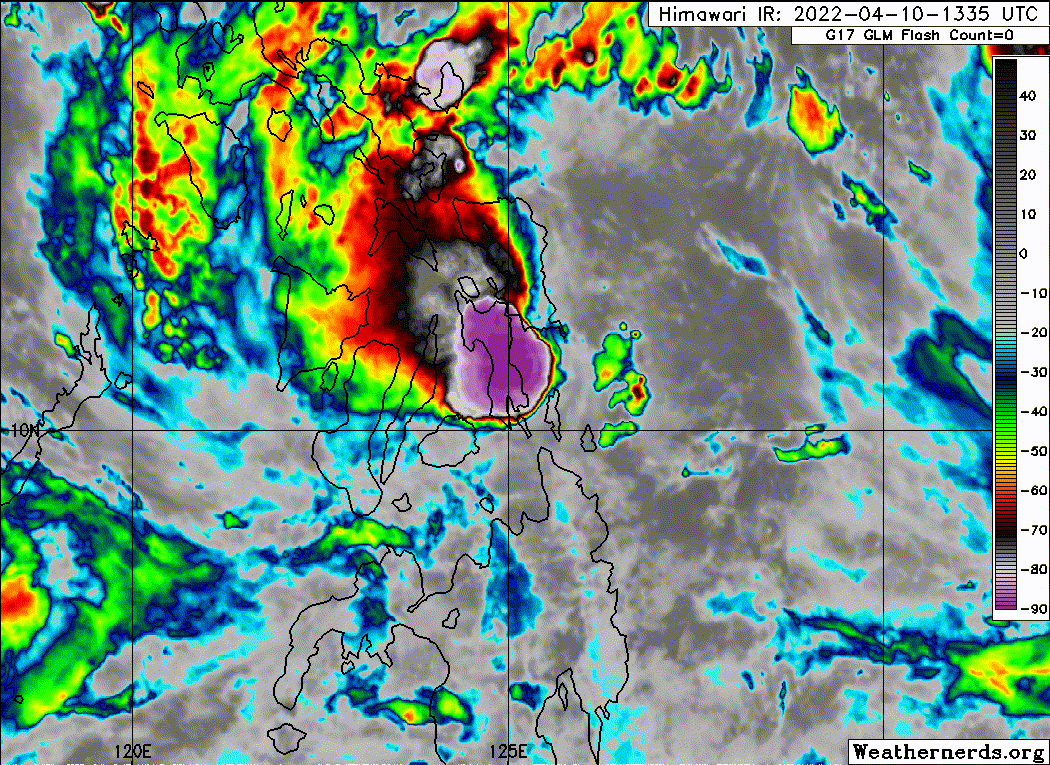
(1) AN AREA OF CONVECTION (REMNANTS 03W) HAS PERSISTED NEAR
10.8N 126.0E, APPROXIMATELY 221 NM NORTH OF DAVAO, PHILIPPINES.
ANIMATED ENHANCED INFRARED SATELLITE IMAGERY DEPICTS A PARTIALLY-
EXPOSED, WEAKLY-DEFINED LOW-LEVEL CIRCULATION WITH FLARING,
DISORGANIZED CONVECTION. A 121937Z SSMIS 37GHZ MICROWAVE IMAGE
INDICATES SHALLOW BANDING AND A WEAKLY-DEFINED LOW-LEVEL
CIRCULATION. THIS DISTURBANCE IS LOCATED WITHIN THE SOUTHWEST
PERIPHERY OF TY 02W AND IS UNDER ITS STRONG EQUATORWARD OUTFLOW WITH
HIGH (25-30 KNOTS) VERTICAL WIND SHEAR. THE GLOBAL MODELS INDICATE A
VERY LOW PROBABILITY OF REGENERATION AS THE SYSTEM ACCELERATES
EASTWARD AND GETS ABSORBED INTO THE SOUTHERN PERIPHERY OF TY 02W.
MAXIMUM SUSTAINED SURFACE WINDS ARE ESTIMATED AT 12 TO 18 KNOTS.
MINIMUM SEA LEVEL PRESSURE IS ESTIMATED TO BE NEAR 1004 MB. THE
POTENTIAL FOR THE DEVELOPMENT OF A SIGNIFICANT TROPICAL CYCLONE
WITHIN THE NEXT 24 HOURS IS LOW.
MSGID/GENADMIN/JOINT TYPHOON WRNCEN PEARL HARBOR HI//
SUBJ/SIGNIFICANT TROPICAL WEATHER ADVISORY FOR THE WESTERN AND
/SOUTH PACIFIC OCEANS/REISSUED/122230Z-130600ZAPR2022//
REF/A/MSG/JOINT TYPHOON WRNCEN PEARL HARBOR HI/121951ZAPR2022//
AMPN/REF A IS A TROPICAL CYCLONE WARNING.//
RMKS/
1. WESTERN NORTH PACIFIC AREA (180 TO MALAY PENINSULA):
A. TROPICAL CYCLONE SUMMARY:
(1) AT 12APR22 1800Z, TYPHOON 02W (MALAKAS) WAS LOCATED NEAR
16.7N 135.9E, APPROXIMATELY 573 NM SOUTH-SOUTHWEST OF IWO TO, AND
HAD TRACKED NORTHEASTWARD AT 08 KNOTS OVER THE PAST SIX HOURS.
MAXIMUM SUSTAINED SURFACE WINDS WERE ESTIMATED AT 95 KNOTS GUSTING
TO 115 KNOTS. SEE REF A (WTPN31 PGTW 122100) FOR FURTHER DETAILS.
(2) NO OTHER TROPICAL CYCLONES.
B. TROPICAL DISTURBANCE SUMMARY:
(1) AN AREA OF CONVECTION (REMNANTS 03W) HAS PERSISTED NEAR
10.8N 126.0E, APPROXIMATELY 221 NM NORTH OF DAVAO, PHILIPPINES.
ANIMATED ENHANCED INFRARED SATELLITE IMAGERY DEPICTS A PARTIALLY-
EXPOSED, WEAKLY-DEFINED LOW-LEVEL CIRCULATION WITH FLARING,
DISORGANIZED CONVECTION. A 121937Z SSMIS 37GHZ MICROWAVE IMAGE
INDICATES SHALLOW BANDING AND A WEAKLY-DEFINED LOW-LEVEL
CIRCULATION. THIS DISTURBANCE IS LOCATED WITHIN THE SOUTHWEST
PERIPHERY OF TY 02W AND IS UNDER ITS STRONG EQUATORWARD OUTFLOW WITH
HIGH (25-30 KNOTS) VERTICAL WIND SHEAR. THE GLOBAL MODELS INDICATE A
VERY LOW PROBABILITY OF REGENERATION AS THE SYSTEM ACCELERATES
EASTWARD AND GETS ABSORBED INTO THE SOUTHERN PERIPHERY OF TY 02W.
MAXIMUM SUSTAINED SURFACE WINDS ARE ESTIMATED AT 12 TO 18 KNOTS.
MINIMUM SEA LEVEL PRESSURE IS ESTIMATED TO BE NEAR 1004 MB. THE
POTENTIAL FOR THE DEVELOPMENT OF A SIGNIFICANT TROPICAL CYCLONE
WITHIN THE NEXT 24 HOURS IS LOW.
0 likes
ヤンデレ女が寝取られるているのを見たい!!!
ECMWF ensemble NWPAC plots: https://ecmwfensnwpac.imgbb.com/
Multimodel NWPAC plots: https://multimodelnwpac.imgbb.com/
GFS Ensemble NWPAC plots (16 & 35 day forecast): https://gefsnwpac.imgbb.com/
Plots updated automatically
ECMWF ensemble NWPAC plots: https://ecmwfensnwpac.imgbb.com/
Multimodel NWPAC plots: https://multimodelnwpac.imgbb.com/
GFS Ensemble NWPAC plots (16 & 35 day forecast): https://gefsnwpac.imgbb.com/
Plots updated automatically
Re: WPAC: INVEST 94W
Hayabusa wrote:This would be a flooding scenario if this occurred
https://i.imgur.com/zSvU51J.gif
More Than 120 Dead After Tropical Storm Hits the Philippines
The first such storm of the year caused widespread flooding and landslides in the central part of the country.
MANILA — Rescue workers battled intermittent heavy rain to reach many people still missing Wednesday, three days after Tropical Storm Megi pummeled the country, causing widespread landslides and flooding in the central Philippines.
By noon Thursday, 123 deaths had been confirmed. Hardest hit was the city of Baybay in central Leyte Province, where landslides buried a remote community. Eighty-six people were known to have died there, local officials said.
https://www.nytimes.com/2022/04/13/worl ... pines.html
0 likes
ヤンデレ女が寝取られるているのを見たい!!!
ECMWF ensemble NWPAC plots: https://ecmwfensnwpac.imgbb.com/
Multimodel NWPAC plots: https://multimodelnwpac.imgbb.com/
GFS Ensemble NWPAC plots (16 & 35 day forecast): https://gefsnwpac.imgbb.com/
Plots updated automatically
ECMWF ensemble NWPAC plots: https://ecmwfensnwpac.imgbb.com/
Multimodel NWPAC plots: https://multimodelnwpac.imgbb.com/
GFS Ensemble NWPAC plots (16 & 35 day forecast): https://gefsnwpac.imgbb.com/
Plots updated automatically
Who is online
Users browsing this forum: No registered users and 39 guests