Texas Spring 2022

U.S. & Caribbean Weather Discussions and Severe Weather Events

Moderator: S2k Moderators

Forum rules

The posts in this forum are NOT official forecast and should not be used as such. They are just the opinion of the poster and may or may not be backed by sound meteorological data. They are NOT endorsed by any professional institution or STORM2K.

Help Support Storm2K
Message
Author
User avatar
Iceresistance
Category 5
Category 5
Posts: 9288
Age: 21
Joined: Sat Oct 10, 2020 9:45 am
Location: Tecumseh, OK/Norman, OK

Re: Texas Spring 2022

#1081 Postby Iceresistance » Mon Apr 11, 2022 9:57 am

Ntxw wrote:There's a small storm heading for DFW airport, maybe it'll overperform and alone does the 0.25" :D.

Sounds like that the storm wants to make sure the DFW will get rain before the DFW Dry Slot activates. :lol:

EDIT: NWS Radar said that parts of Fort Worth already got .5 inch of rain, so maybe .5 inch at the airport?
0 likes   
Bill 2015 & Beta 2020

Winter 2020-2021 :cold:

All observations are in Tecumseh, OK unless otherwise noted.

Winter posts are focused mainly for Oklahoma & Texas.

Take any of my forecasts with a grain of salt, refer to the NWS, SPC, and NHC for official information

Never say Never with weather! Because ANYTHING is possible!

User avatar
Edwards Limestone
S2K Supporter
S2K Supporter
Posts: 476
Age: 36
Joined: Tue Dec 28, 2021 11:05 am
Location: Smithson Valley, TX

Re: Texas Spring 2022

#1082 Postby Edwards Limestone » Mon Apr 11, 2022 10:41 am

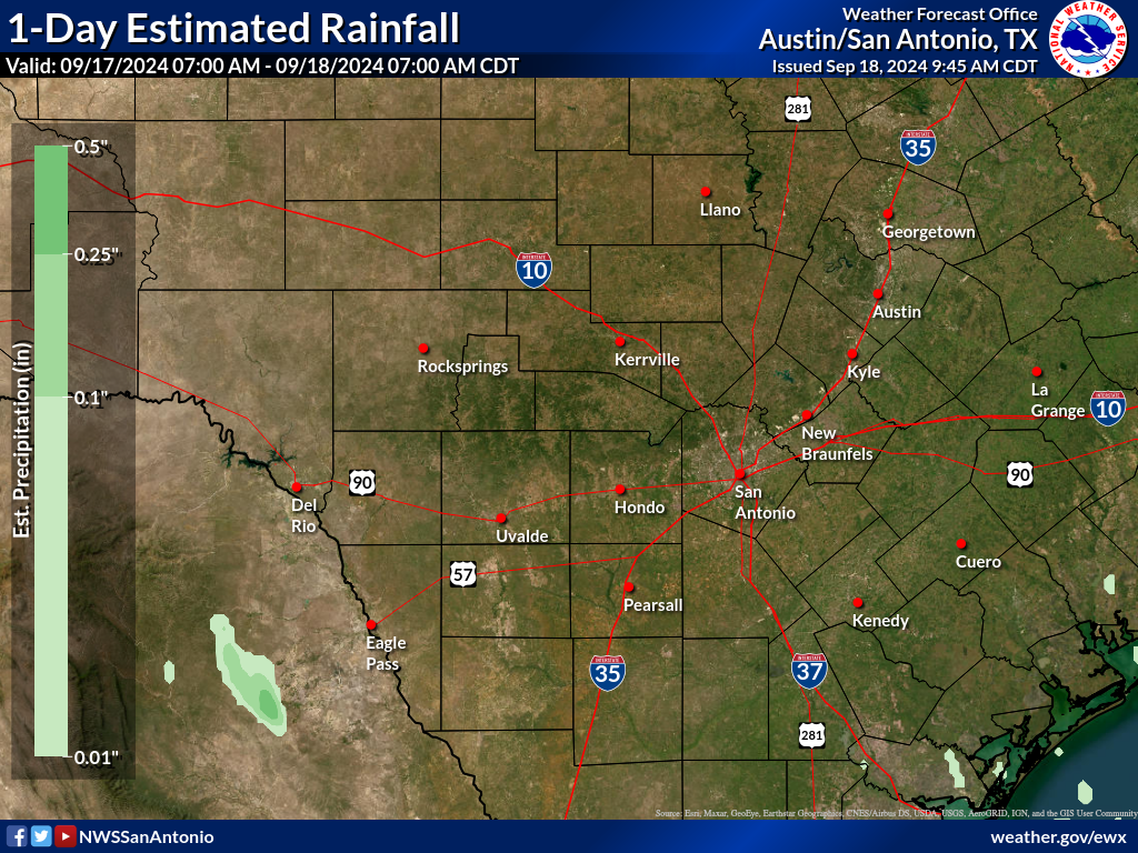
It wasn't much, but SA and the southern Edwards Plateau got some much needed rain late last night.
Nice after missing out on the last 2-3 events.

Image
https://www.weather.gov/images/ewx/products/rainfall/rainfall1day.png
1 likes   
The above post is NOT an official forecast and should not be used as such. It is just the opinion of the poster and may or may not be backed by sound meteorological data. It is NOT endorsed by any professional institution including Storm2k. For official information, please refer to NWS products.

User avatar
Ntxw
Storm2k Moderator
Storm2k Moderator
Posts: 22785
Joined: Wed Oct 21, 2009 6:34 pm
Location: DFW, Texas

Re: Texas Spring 2022

#1083 Postby Ntxw » Mon Apr 11, 2022 10:43 am

Iceresistance wrote:
Ntxw wrote:There's a small storm heading for DFW airport, maybe it'll overperform and alone does the 0.25" :D.

Sounds like that the storm wants to make sure the DFW will get rain before the DFW Dry Slot activates. :lol:

EDIT: NWS Radar said that parts of Fort Worth already got .5 inch of rain, so maybe .5 inch at the airport?


Only a trace. It faded as it crossed at least the northern end.
0 likes   
The above post and any post by Ntxw is NOT an official forecast and should not be used as such. It is just the opinion of the poster and may or may not be backed by sound meteorological data. It is NOT endorsed by any professional institution including Storm2k. For official information, please refer to NWS products.

  Help support Storm2K!
Help Support Storm2K

User avatar
Iceresistance
Category 5
Category 5
Posts: 9288
Age: 21
Joined: Sat Oct 10, 2020 9:45 am
Location: Tecumseh, OK/Norman, OK

Re: Texas Spring 2022

#1084 Postby Iceresistance » Mon Apr 11, 2022 10:55 am

Ntxw wrote:
Iceresistance wrote:
Ntxw wrote:There's a small storm heading for DFW airport, maybe it'll overperform and alone does the 0.25" :D.

Sounds like that the storm wants to make sure the DFW will get rain before the DFW Dry Slot activates. :lol:

EDIT: NWS Radar said that parts of Fort Worth already got .5 inch of rain, so maybe .5 inch at the airport?


Only a trace. It faded as it crossed at least the northern end.

Curses! The DFW Dry Slot strikes again! This time, it's only at DFW Airport!
0 likes   
Bill 2015 & Beta 2020

Winter 2020-2021 :cold:

All observations are in Tecumseh, OK unless otherwise noted.

Winter posts are focused mainly for Oklahoma & Texas.

Take any of my forecasts with a grain of salt, refer to the NWS, SPC, and NHC for official information

Never say Never with weather! Because ANYTHING is possible!

User avatar
bubba hotep
S2K Supporter
S2K Supporter
Posts: 5837
Joined: Wed Dec 28, 2016 1:00 am
Location: Collin County Texas

Re: Texas Spring 2022

#1085 Postby bubba hotep » Mon Apr 11, 2022 11:57 am

Decent little storm moved through hear earlier with brief heavy rain and some pea sized hail.

Sometimes areas that pick up early storms see a repeat later in the day with these setups. The 12z models agree that convection will try to fire this afternoon along the dryline in N. TX but it looks like most have these attempts fail and the cap hold strong.
1 likes   
Winter time post are almost exclusively focused on the DFW area.

rwfromkansas
Category 5
Category 5
Posts: 2627
Joined: Sat Aug 27, 2005 12:47 am
Location: North Fort Worth

Re: Texas Spring 2022

#1086 Postby rwfromkansas » Mon Apr 11, 2022 12:08 pm

Do early storms like that help provide a hole in the cap so to speak?

That storm was quite strong for a surprise storm when it passed maybe 2 miles south of me.
0 likes   

User avatar
ElectricStorm
Category 5
Category 5
Posts: 5044
Age: 24
Joined: Tue Aug 13, 2019 11:23 pm
Location: Skiatook, OK / Norman, OK

Re: Texas Spring 2022

#1087 Postby ElectricStorm » Mon Apr 11, 2022 12:33 pm

10 hatched tornado area removed except for the part further north in IA that will probably get upgraded to moderate tomorrow IMO. Partial cap bust likely for KS/OK/TX with a few storms forming but not many. Still some large hail and tornado potential, but it's probably going to join the ever growing list of failed/underwhelming attempts we've seen since 2013. I don't root for outbreaks but we desperately need rain and the only we'll get some tomorrow is if anything can break the cap.

We're probably going to set some sort of record for number of extreme fire risk days this year, at least that's what it feels like so far.
0 likes   
B.S Meteorology, University of Oklahoma '25

Please refer to the NHC, NWS, or SPC for official information.

User avatar
cheezyWXguy
Category 5
Category 5
Posts: 6108
Joined: Mon Feb 13, 2006 12:29 am
Location: Dallas, TX

Re: Texas Spring 2022

#1088 Postby cheezyWXguy » Mon Apr 11, 2022 12:52 pm

Weather Dude wrote:10 hatched tornado area removed except for the part further north in IA that will probably get upgraded to moderate tomorrow IMO. Partial cap bust likely for KS/OK/TX with a few storms forming but not many. Still some large hail and tornado potential, but it's probably going to join the ever growing list of failed/underwhelming attempts we've seen since 2013. I don't root for outbreaks but we desperately need rain and the only we'll get some tomorrow is if anything can break the cap.

We're probably going to set some sort of record for number of extreme fire risk days this year, at least that's what it feels like so far.

You could be right but I think it’s still a bit up in the air, even for today. As far as ntx goes, current temps are running about 3 degrees above what the HRRR is depicting for 1pm. There’s also the chance that the storms earlier left any kind of localized surface boundary or perturbation. Both of these factors probably add support to convective initiation this afternoon, but the question is whether it’s enough to set something off. I’m not convinced either way. However, for tomorrow similar factors should be taken into consideration, every degree the risk area warms above forecast would increase the chances of a cap break.
0 likes   

HockeyTx82
S2K Supporter
S2K Supporter
Posts: 2540
Joined: Tue Oct 27, 2009 11:17 am
Location: Ponder, TX

Re: Texas Spring 2022

#1089 Postby HockeyTx82 » Mon Apr 11, 2022 12:53 pm

cheezyWXguy wrote:
Weather Dude wrote:10 hatched tornado area removed except for the part further north in IA that will probably get upgraded to moderate tomorrow IMO. Partial cap bust likely for KS/OK/TX with a few storms forming but not many. Still some large hail and tornado potential, but it's probably going to join the ever growing list of failed/underwhelming attempts we've seen since 2013. I don't root for outbreaks but we desperately need rain and the only we'll get some tomorrow is if anything can break the cap.

We're probably going to set some sort of record for number of extreme fire risk days this year, at least that's what it feels like so far.

You could be right but I think it’s still a bit up in the air, even for today. As far as ntx goes, current temps are running about 3 degrees above what the HRRR is depicting for 1pm. There’s also the chance that the storms earlier left any kind of localized surface boundary or perturbation. Both of these factors probably add support to convective initiation this afternoon, but the question is whether it’s enough to set something off. I’m not convinced either way. However, for tomorrow similar factors should be taken into consideration, every degree the risk area warms above forecast would increase the chances of a cap break.


What temp do we need to bust the cap?
0 likes   
Don't hold me accountable for anything I post on this forum. Leave the real forecasting up to the professionals.

Location: Ponder, TX (all observation posts are this location unless otherwise noted)

User avatar
ElectricStorm
Category 5
Category 5
Posts: 5044
Age: 24
Joined: Tue Aug 13, 2019 11:23 pm
Location: Skiatook, OK / Norman, OK

Re: Texas Spring 2022

#1090 Postby ElectricStorm » Mon Apr 11, 2022 12:57 pm

cheezyWXguy wrote:
Weather Dude wrote:10 hatched tornado area removed except for the part further north in IA that will probably get upgraded to moderate tomorrow IMO. Partial cap bust likely for KS/OK/TX with a few storms forming but not many. Still some large hail and tornado potential, but it's probably going to join the ever growing list of failed/underwhelming attempts we've seen since 2013. I don't root for outbreaks but we desperately need rain and the only we'll get some tomorrow is if anything can break the cap.

We're probably going to set some sort of record for number of extreme fire risk days this year, at least that's what it feels like so far.

You could be right but I think it’s still a bit up in the air, even for today. As far as ntx goes, current temps are running about 3 degrees above what the HRRR is depicting for 1pm. There’s also the chance that the storms earlier left any kind of localized surface boundary or perturbation. Both of these factors probably add support to convective initiation this afternoon, but the question is whether it’s enough to set something off. I’m not convinced either way. However, for tomorrow similar factors should be taken into consideration, every degree the risk area warms above forecast would increase the chances of a cap break.

Yeah we'll see. A lot of times the complete opposite of what I say happens so if KS/OK/TX goes off and IA cap busts tomorrow don't come hunt me down lol
0 likes   
B.S Meteorology, University of Oklahoma '25

Please refer to the NHC, NWS, or SPC for official information.

User avatar
cheezyWXguy
Category 5
Category 5
Posts: 6108
Joined: Mon Feb 13, 2006 12:29 am
Location: Dallas, TX

Re: Texas Spring 2022

#1091 Postby cheezyWXguy » Mon Apr 11, 2022 1:02 pm

HockeyTx82 wrote:
cheezyWXguy wrote:
Weather Dude wrote:10 hatched tornado area removed except for the part further north in IA that will probably get upgraded to moderate tomorrow IMO. Partial cap bust likely for KS/OK/TX with a few storms forming but not many. Still some large hail and tornado potential, but it's probably going to join the ever growing list of failed/underwhelming attempts we've seen since 2013. I don't root for outbreaks but we desperately need rain and the only we'll get some tomorrow is if anything can break the cap.

We're probably going to set some sort of record for number of extreme fire risk days this year, at least that's what it feels like so far.

You could be right but I think it’s still a bit up in the air, even for today. As far as ntx goes, current temps are running about 3 degrees above what the HRRR is depicting for 1pm. There’s also the chance that the storms earlier left any kind of localized surface boundary or perturbation. Both of these factors probably add support to convective initiation this afternoon, but the question is whether it’s enough to set something off. I’m not convinced either way. However, for tomorrow similar factors should be taken into consideration, every degree the risk area warms above forecast would increase the chances of a cap break.


What temp do we need to bust the cap?

Not totally sure but it looks like around 90. Capping is virtually gone over the metro from 3-6pm on the hrrr when it forecasts temps around that. Still, no initiation from it though. It must be due to lack of forcing, it seems like a bird fart could set off a storm in these kinds of conditions.
0 likes   

User avatar
Iceresistance
Category 5
Category 5
Posts: 9288
Age: 21
Joined: Sat Oct 10, 2020 9:45 am
Location: Tecumseh, OK/Norman, OK

Re: Texas Spring 2022

#1092 Postby Iceresistance » Mon Apr 11, 2022 1:40 pm

cheezyWXguy wrote:
HockeyTx82 wrote:
cheezyWXguy wrote:You could be right but I think it’s still a bit up in the air, even for today. As far as ntx goes, current temps are running about 3 degrees above what the HRRR is depicting for 1pm. There’s also the chance that the storms earlier left any kind of localized surface boundary or perturbation. Both of these factors probably add support to convective initiation this afternoon, but the question is whether it’s enough to set something off. I’m not convinced either way. However, for tomorrow similar factors should be taken into consideration, every degree the risk area warms above forecast would increase the chances of a cap break.


What temp do we need to bust the cap?

Not totally sure but it looks like around 90. Capping is virtually gone over the metro from 3-6pm on the hrrr when it forecasts temps around that. Still, no initiation from it though. It must be due to lack of forcing, it seems like a bird fart could set off a storm in these kinds of conditions.

More like a loaded cannon that is absolutely ready to fire, but the Spark is missing, even thought it does not take much spark for the Supercells to literally explode on radar.
0 likes   
Bill 2015 & Beta 2020

Winter 2020-2021 :cold:

All observations are in Tecumseh, OK unless otherwise noted.

Winter posts are focused mainly for Oklahoma & Texas.

Take any of my forecasts with a grain of salt, refer to the NWS, SPC, and NHC for official information

Never say Never with weather! Because ANYTHING is possible!

User avatar
Iceresistance
Category 5
Category 5
Posts: 9288
Age: 21
Joined: Sat Oct 10, 2020 9:45 am
Location: Tecumseh, OK/Norman, OK

Re: Texas Spring 2022

#1093 Postby Iceresistance » Mon Apr 11, 2022 1:41 pm

Weather Dude wrote:We're probably going to set some sort of record for number of extreme fire risk days this year, at least that's what it feels like so far.

I've looked at the list of Extreme Fire Risk Days, & 2006 had 20 of them, with the first one (Ironically) on New Years day in Oklahoma & Texas
0 likes   
Bill 2015 & Beta 2020

Winter 2020-2021 :cold:

All observations are in Tecumseh, OK unless otherwise noted.

Winter posts are focused mainly for Oklahoma & Texas.

Take any of my forecasts with a grain of salt, refer to the NWS, SPC, and NHC for official information

Never say Never with weather! Because ANYTHING is possible!

User avatar
cheezyWXguy
Category 5
Category 5
Posts: 6108
Joined: Mon Feb 13, 2006 12:29 am
Location: Dallas, TX

Re: Texas Spring 2022

#1094 Postby cheezyWXguy » Mon Apr 11, 2022 3:01 pm

18z 3k NAM shows initiation today in ntx around 6pm
Image
Image
0 likes   

User avatar
Iceresistance
Category 5
Category 5
Posts: 9288
Age: 21
Joined: Sat Oct 10, 2020 9:45 am
Location: Tecumseh, OK/Norman, OK

Re: Texas Spring 2022

#1095 Postby Iceresistance » Mon Apr 11, 2022 3:20 pm

cheezyWXguy wrote:18z 3k NAM shows initiation today in ntx around 6pm
[url]=https://ibb.co/2PwZYrk[/url]
[url]=https://ibb.co/yyL3qny[/url]

Maybe the early morning storms over DFW messed up the capping potential?
0 likes   
Bill 2015 & Beta 2020

Winter 2020-2021 :cold:

All observations are in Tecumseh, OK unless otherwise noted.

Winter posts are focused mainly for Oklahoma & Texas.

Take any of my forecasts with a grain of salt, refer to the NWS, SPC, and NHC for official information

Never say Never with weather! Because ANYTHING is possible!

User avatar
Iceresistance
Category 5
Category 5
Posts: 9288
Age: 21
Joined: Sat Oct 10, 2020 9:45 am
Location: Tecumseh, OK/Norman, OK

Re: Texas Spring 2022

#1096 Postby Iceresistance » Mon Apr 11, 2022 3:21 pm

The NWS-Springfield Radar is dead, Lightning struck it & blew up some parts, they're trying to get replacement parts back in as fast as possible, but the restoration time is unknown
0 likes   
Bill 2015 & Beta 2020

Winter 2020-2021 :cold:

All observations are in Tecumseh, OK unless otherwise noted.

Winter posts are focused mainly for Oklahoma & Texas.

Take any of my forecasts with a grain of salt, refer to the NWS, SPC, and NHC for official information

Never say Never with weather! Because ANYTHING is possible!

User avatar
cheezyWXguy
Category 5
Category 5
Posts: 6108
Joined: Mon Feb 13, 2006 12:29 am
Location: Dallas, TX

Re: Texas Spring 2022

#1097 Postby cheezyWXguy » Mon Apr 11, 2022 3:25 pm

Iceresistance wrote:
cheezyWXguy wrote:18z 3k NAM shows initiation today in ntx around 6pm
[url]=https://ibb.co/2PwZYrk[/url]
[url]=https://ibb.co/yyL3qny[/url]

Maybe the early morning storms over DFW messed up the capping potential?

Maybe but it doesn’t even seem like capping is the issue. Nam and hrrr have been showing next to no capping for a few runs now, maybe they were overestimating how much forcing it would take to fire these off. Still, I guess we won’t know until something actually happens
0 likes   

User avatar
ElectricStorm
Category 5
Category 5
Posts: 5044
Age: 24
Joined: Tue Aug 13, 2019 11:23 pm
Location: Skiatook, OK / Norman, OK

Re: Texas Spring 2022

#1098 Postby ElectricStorm » Mon Apr 11, 2022 3:35 pm

Tornado watch is up with 70/40 probs. Dangerous day ahead
0 likes   
B.S Meteorology, University of Oklahoma '25

Please refer to the NHC, NWS, or SPC for official information.

User avatar
Haris
Category 5
Category 5
Posts: 1810
Joined: Mon Nov 27, 2017 8:19 pm
Location: ( Bee Cave) West Austin, Texas

Re: Texas Spring 2022

#1099 Postby Haris » Mon Apr 11, 2022 3:50 pm

Iceresistance wrote:
cheezyWXguy wrote:18z 3k NAM shows initiation today in ntx around 6pm
[url]=https://ibb.co/2PwZYrk[/url]
[url]=https://ibb.co/yyL3qny[/url]

Maybe the early morning storms over DFW messed up the capping potential?


Those were too small for impact. And more importantly the models never had anything before either
0 likes   
Weather geek and a storm spotter in West Austin. Not a degreed meteorologist. Big snow fan. Love rain and cold! Despise heat!

HockeyTx82
S2K Supporter
S2K Supporter
Posts: 2540
Joined: Tue Oct 27, 2009 11:17 am
Location: Ponder, TX

Re: Texas Spring 2022

#1100 Postby HockeyTx82 » Mon Apr 11, 2022 4:32 pm

Seeing some small returns west of Ponder from UNT.

Maybe something trying to get going?

The clouds look very elevated.... who knows
0 likes   
Don't hold me accountable for anything I post on this forum. Leave the real forecasting up to the professionals.

Location: Ponder, TX (all observation posts are this location unless otherwise noted)


Return to “USA & Caribbean Weather”

Who is online

Users browsing this forum: No registered users and 21 guests