Texas Spring 2022
Moderator: S2k Moderators
Forum rules

The posts in this forum are NOT official forecast and should not be used as such. They are just the opinion of the poster and may or may not be backed by sound meteorological data. They are NOT endorsed by any professional institution or STORM2K.
-
cheezyWXguy

- Category 5

- Posts: 6282
- Joined: Mon Feb 13, 2006 12:29 am
- Location: Dallas, TX
Re: Texas Spring 2022
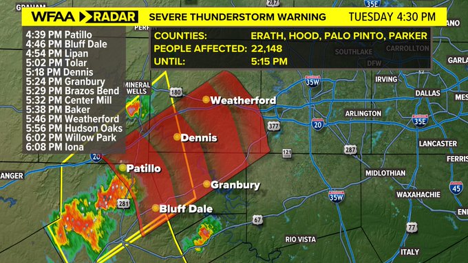
Something is trying to go up over Eastland. Given its location directly west of dfw, I would be concerned about it’s impacts if it, or anything that develops in that area, manages to root into the surface layer
0 likes
-
Edwards Limestone

- S2K Supporter

- Posts: 510
- Age: 36
- Joined: Tue Dec 28, 2021 11:05 am
- Location: Smithson Valley, TX
Re: Texas Spring 2022
0 likes
The above post is NOT an official forecast and should not be used as such. It is just the opinion of the poster and may or may not be backed by sound meteorological data. It is NOT endorsed by any professional institution including Storm2k. For official information, please refer to NWS products.
-
Iceresistance

- Category 5
- Posts: 9581
- Age: 22
- Joined: Sat Oct 10, 2020 9:45 am
- Location: Tecumseh, OK/Norman, OK
Re: Texas Spring 2022
Radar is not picking up the dry line in Oklahoma, did it pass me already? Or has it not shown itself yet?
0 likes
Bill 2015 & Beta 2020
Winter 2020-2021
All observations are in Tecumseh, OK unless otherwise noted.
Winter posts are focused mainly for Oklahoma & Texas.
Take any of my forecasts with a grain of salt, refer to the NWS, SPC, and NHC for official information
Never say Never with weather! Because ANYTHING is possible!
Winter 2020-2021
All observations are in Tecumseh, OK unless otherwise noted.
Winter posts are focused mainly for Oklahoma & Texas.
Take any of my forecasts with a grain of salt, refer to the NWS, SPC, and NHC for official information
Never say Never with weather! Because ANYTHING is possible!
-
HockeyTx82
- S2K Supporter
- Posts: 2791
- Joined: Tue Oct 27, 2009 11:17 am
- Location: Ponder, TX
Re: Texas Spring 2022
Latest HRRR looks to have this cluster pass south of Dallas and nothing for the northern burbs.
0 likes
Don't hold me accountable for anything I post on this forum. Leave the real forecasting up to the professionals.
Location: Ponder, TX (all observation posts are this location unless otherwise noted)
Location: Ponder, TX (all observation posts are this location unless otherwise noted)
-
Iceresistance
- Category 5
- Posts: 9581
- Age: 22
- Joined: Sat Oct 10, 2020 9:45 am
- Location: Tecumseh, OK/Norman, OK
Re: Texas Spring 2022
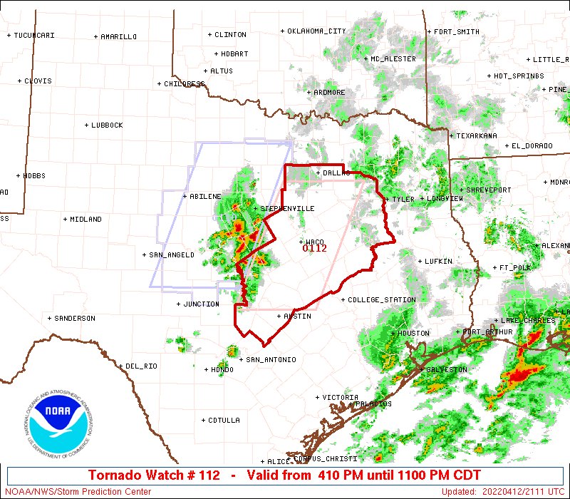
Tornado Watch in effect for Central, Northern, Southern Texas.
1 likes
Bill 2015 & Beta 2020
Winter 2020-2021
All observations are in Tecumseh, OK unless otherwise noted.
Winter posts are focused mainly for Oklahoma & Texas.
Take any of my forecasts with a grain of salt, refer to the NWS, SPC, and NHC for official information
Never say Never with weather! Because ANYTHING is possible!
Winter 2020-2021
All observations are in Tecumseh, OK unless otherwise noted.
Winter posts are focused mainly for Oklahoma & Texas.
Take any of my forecasts with a grain of salt, refer to the NWS, SPC, and NHC for official information
Never say Never with weather! Because ANYTHING is possible!
-
rwfromkansas
- Category 5
- Posts: 3032
- Joined: Sat Aug 27, 2005 12:47 am
- Location: North Fort Worth
Re: Texas Spring 2022
Starting to fill in, but need more north for DFW to get in on it if you want it.
0 likes
-
bubba hotep

- S2K Supporter
- Posts: 6014
- Joined: Wed Dec 28, 2016 1:00 am
- Location: Collin County Texas
Re: Texas Spring 2022
Iceresistance wrote:Tornado Watch in effect for Central, Northern, Southern Texas.
0 likes
Winter time post are almost exclusively focused on the DFW area.

Re: Texas Spring 2022
bubba hotep wrote:Iceresistance wrote:Tornado Watch in effect for Central, Northern, Southern Texas.
https://pbs.twimg.com/media/FQLEZfpUYAEUWnu?format=jpg&name=medium
I20 and South
1 likes
-
Edwards Limestone
- S2K Supporter
- Posts: 510
- Age: 36
- Joined: Tue Dec 28, 2021 11:05 am
- Location: Smithson Valley, TX
Re: Texas Spring 2022
Storms seem to be struggling to get surface-based down here. Lots of convective initiation, but not really sustaining yet.
2 likes
The above post is NOT an official forecast and should not be used as such. It is just the opinion of the poster and may or may not be backed by sound meteorological data. It is NOT endorsed by any professional institution including Storm2k. For official information, please refer to NWS products.
-
Brent
- S2K Supporter
- Posts: 38739
- Age: 37
- Joined: Sun May 16, 2004 10:30 pm
- Location: Tulsa Oklahoma
- Contact:
Re: Texas Spring 2022
Some of those storms southwest of DFW are starting to get suspicious looking
Last edited by Brent on Tue Apr 12, 2022 4:40 pm, edited 1 time in total.
1 likes
#neversummer
-
bubba hotep
- S2K Supporter
- Posts: 6014
- Joined: Wed Dec 28, 2016 1:00 am
- Location: Collin County Texas
Re: Texas Spring 2022
Delkus is on the job.
0 likes
Winter time post are almost exclusively focused on the DFW area.
-
bubba hotep
- S2K Supporter
- Posts: 6014
- Joined: Wed Dec 28, 2016 1:00 am
- Location: Collin County Texas
Re: Texas Spring 2022
Brent wrote:Some of those storms southwest of DFW are starting to get suspicious looking
It's going to merge with the smaller cell out in front of it. However, it looks like the cluster to the south is starting to build northward, so that probably overtakes that little hook cell later on.
0 likes
Winter time post are almost exclusively focused on the DFW area.
-
UTSARoadrunner4
- Category 1

- Posts: 265
- Age: 29
- Joined: Wed Aug 26, 2020 11:19 pm
Re: Texas Spring 2022
Storm near UTSA got a “Special Weather Statement” for 40 MPH winds and Nickel Size Hail. Only storm so far that’s sustaining itself down here. Probably should be something to worry about to for points to the NE.
1 likes
-
ElectricStorm

- Category 5
- Posts: 5146
- Age: 25
- Joined: Tue Aug 13, 2019 11:23 pm
- Location: Norman, OK
Re: Texas Spring 2022
Might be a tornado on the ground north of Killeen. Small CC drop.
EDIT: Just went tor warned
EDIT: Just went tor warned
1 likes
B.S Meteorology, University of Oklahoma '25
Please refer to the NHC, NWS, or SPC for official information.
Please refer to the NHC, NWS, or SPC for official information.
-
rwfromkansas
- Category 5
- Posts: 3032
- Joined: Sat Aug 27, 2005 12:47 am
- Location: North Fort Worth
Re: Texas Spring 2022
I will maybe get the northern edge, but it’s a close call. The storm heading to Tarrant is expanding north as it goes east like the FV3 showed today actually. It is getting large.
Edit…it is tracking more NE and becoming discrete. Uh oh.
Edit…it is tracking more NE and becoming discrete. Uh oh.
0 likes
-
Texas Snowman

- Storm2k Moderator

- Posts: 6197
- Joined: Fri Jan 25, 2008 11:29 am
- Location: Denison, Texas
Re: Texas Spring 2022
Severe Weather Statement
National Weather Service Fort Worth TX
514 PM CDT Tue Apr 12 2022
TXC027-099-122245-
/O.CON.KFWD.TO.W.0033.000000T0000Z-220412T2245Z/
Coryell TX-Bell TX-
514 PM CDT Tue Apr 12 2022
...A TORNADO WARNING REMAINS IN EFFECT UNTIL 545 PM CDT FOR EAST
CENTRAL CORYELL AND NORTH CENTRAL BELL COUNTIES...
At 513 PM CDT, a confirmed tornado was located near Fort Gates, or 8
miles south of Gatesville, moving northeast at 25 mph.
HAZARD...Damaging tornado and half dollar size hail.
SOURCE...Weather spotters confirmed tornado.
IMPACT...Flying debris will be dangerous to those caught without
shelter. Mobile homes will be damaged or destroyed. Damage
to roofs, windows, and vehicles will occur. Tree damage is
likely.
This tornadic thunderstorm will remain over mainly rural areas of
east central Coryell and north central Bell Counties, including the
following locations... Oglesby.
PRECAUTIONARY/PREPAREDNESS ACTIONS...
To repeat, a tornado is on the ground. TAKE COVER NOW! If you are
outdoors, in a mobile home, or in a vehicle, move to the closest
substantial shelter now! Get to an interior room on the lowest floor
of a sturdy building and avoid windows.
Heavy rainfall may hide this tornado. Do not wait to see or hear the
tornado. TAKE COVER NOW!
&&
LAT...LON 3133 9784 3145 9751 3132 9742 3124 9734
3124 9781
TIME...MOT...LOC 2213Z 223DEG 21KT 3132 9776
TORNADO...OBSERVED
MAX HAIL SIZE...1.25 IN
0 likes
The above post and any post by Texas Snowman is NOT an official forecast and should not be used as such. It is just the opinion of the poster and may or may not be backed by sound meteorological data. It is NOT endorsed by any professional institution including storm2k.org. For official information, please refer to NWS products.
-
Iceresistance
- Category 5
- Posts: 9581
- Age: 22
- Joined: Sat Oct 10, 2020 9:45 am
- Location: Tecumseh, OK/Norman, OK
Re: Texas Spring 2022
rwfromkansas wrote:I will maybe get the northern edge, but it’s a close call. The storm heading to Tarrant is expanding north as it goes east like the FV3 showed today actually. It is getting large.
Edit…it is tracking more NE and becoming discrete. Uh oh.
Uh Oh is right when there's a lonely Supercell, & Lonely Supercells are more dangerous because they have more unimpeded inflow & will be more likely produce tornadoes.
0 likes
Bill 2015 & Beta 2020
Winter 2020-2021
All observations are in Tecumseh, OK unless otherwise noted.
Winter posts are focused mainly for Oklahoma & Texas.
Take any of my forecasts with a grain of salt, refer to the NWS, SPC, and NHC for official information
Never say Never with weather! Because ANYTHING is possible!
Winter 2020-2021
All observations are in Tecumseh, OK unless otherwise noted.
Winter posts are focused mainly for Oklahoma & Texas.
Take any of my forecasts with a grain of salt, refer to the NWS, SPC, and NHC for official information
Never say Never with weather! Because ANYTHING is possible!
-
Texas Snowman
- Storm2k Moderator
- Posts: 6197
- Joined: Fri Jan 25, 2008 11:29 am
- Location: Denison, Texas
Re: Texas Spring 2022
BULLETIN - EAS ACTIVATION REQUESTED
Tornado Warning
National Weather Service Austin/San Antonio TX
522 PM CDT Tue Apr 12 2022
The National Weather Service in Austin San Antonio has issued a
* Tornado Warning for...
North central Williamson County in south central Texas...
* Until 545 PM CDT.
* At 520 PM CDT, a severe thunderstorm capable of producing a tornado
was located near Florence, or 15 miles northwest of Serenada,
moving east at 25 mph.
HAZARD...Tornado and quarter size hail.
SOURCE...Radar indicated rotation.
IMPACT...Flying debris will be dangerous to those caught without
shelter. Mobile homes will be damaged or destroyed.
Damage to roofs, windows, and vehicles will occur. Tree
damage is likely.
* Locations impacted include...
Florence.
PRECAUTIONARY/PREPAREDNESS ACTIONS...
TAKE COVER NOW! Move to a basement or an interior room on the lowest
floor of a sturdy building. Avoid windows. If you are outdoors, in a
mobile home, or in a vehicle, move to the closest substantial shelter
and protect yourself from flying debris.
&&
LAT...LON 3090 9775 3087 9762 3086 9762 3084 9788
3086 9788 3091 9783
TIME...MOT...LOC 2220Z 255DEG 22KT 3088 9783
TORNADO...RADAR INDICATED
MAX HAIL SIZE...1.00 IN
0 likes
The above post and any post by Texas Snowman is NOT an official forecast and should not be used as such. It is just the opinion of the poster and may or may not be backed by sound meteorological data. It is NOT endorsed by any professional institution including storm2k.org. For official information, please refer to NWS products.
-
Iceresistance
- Category 5
- Posts: 9581
- Age: 22
- Joined: Sat Oct 10, 2020 9:45 am
- Location: Tecumseh, OK/Norman, OK
Re: Texas Spring 2022
Storms coming into Western Fort Worth, looks like the Entire Metroplex will get rained on.
0 likes
Bill 2015 & Beta 2020
Winter 2020-2021
All observations are in Tecumseh, OK unless otherwise noted.
Winter posts are focused mainly for Oklahoma & Texas.
Take any of my forecasts with a grain of salt, refer to the NWS, SPC, and NHC for official information
Never say Never with weather! Because ANYTHING is possible!
Winter 2020-2021
All observations are in Tecumseh, OK unless otherwise noted.
Winter posts are focused mainly for Oklahoma & Texas.
Take any of my forecasts with a grain of salt, refer to the NWS, SPC, and NHC for official information
Never say Never with weather! Because ANYTHING is possible!
-
Texas Snowman
- Storm2k Moderator
- Posts: 6197
- Joined: Fri Jan 25, 2008 11:29 am
- Location: Denison, Texas
Re: Texas Spring 2022
BULLETIN - EAS ACTIVATION REQUESTED
Tornado Warning
National Weather Service Fort Worth TX
524 PM CDT Tue Apr 12 2022
The National Weather Service in Fort Worth has issued a
* Tornado Warning for...
Southwestern Bell County in central Texas...
* Until 615 PM CDT.
* At 524 PM CDT, a severe thunderstorm capable of producing a
tornado was located near Florence, or 15 miles southwest of Harker
Heights, moving east at 30 mph.
HAZARD...Tornado and golf ball size hail.
SOURCE...Radar indicated rotation.
IMPACT...Flying debris will be dangerous to those caught without
shelter. Mobile homes will be damaged or destroyed.
Damage to roofs, windows, and vehicles will occur. Tree
damage is likely.
This includes Interstate 35 between mile markers 277 and 291.
PRECAUTIONARY/PREPAREDNESS ACTIONS...
TAKE COVER NOW! Move to an interior room on the lowest floor of a
sturdy building. Avoid windows. If you are outdoors, in a mobile
home, or in a vehicle, move to the closest substantial shelter and
protect yourself from flying debris.
&&
LAT...LON 3083 9753 3087 9763 3091 9783 3095 9785
3116 9748 3083 9745
TIME...MOT...LOC 2224Z 248DEG 26KT 3089 9780
TORNADO...RADAR INDICATED
MAX HAIL SIZE...1.75 IN
1 likes
The above post and any post by Texas Snowman is NOT an official forecast and should not be used as such. It is just the opinion of the poster and may or may not be backed by sound meteorological data. It is NOT endorsed by any professional institution including storm2k.org. For official information, please refer to NWS products.
Return to “USA & Caribbean Weather”
Who is online
Users browsing this forum: No registered users and 26 guests