2022 Indicators (SSTs/SAL/MSLP/Shear/Steering/Instability) and >Day 16 Models
Moderator: S2k Moderators
Forum rules

The posts in this forum are NOT official forecasts and should not be used as such. They are just the opinion of the poster and may or may not be backed by sound meteorological data. They are NOT endorsed by any professional institution or STORM2K. For official information, please refer to products from the National Hurricane Center and National Weather Service.
-
Shell Mound
- Category 5

- Posts: 2432
- Age: 33
- Joined: Thu Sep 07, 2017 3:39 pm
- Location: St. Petersburg, FL → Scandinavia
Re: 2022 indicators: SSTs / SAL / MSLP / shear / steering / instability / images
I’m really not sure as to why people are downplaying the potential for hyperactivity. Consider that 2020 had warmer SST in the MDR during May–June than 2021 did, yet ended up featuring less intense activity in the MDR than the latter season. Some people credited the Atlantic Niño, but the latter tends to suppress the ITCZ, so one would not have expected storms like Larry and Sam—both of which maintained high intensities for extended periods—in the MDR in ‘21. If SSTs were the sole determinant, than 2021’s activity in the MDR should have occurred in 2020, and 2005 should have had 2017-type activity in the MDR. The overall global background state in 2022 looks to be on par with that which typically attends the most active seasons, so even relatively marginal SSTs should be enough to generate above-average activity in the deep tropics. The subtropical northwestern North Atlantic may be warm, but the region south of Greenland and near the Canary Islands is warmer than in the past few seasons. Once the trades slow down I think the MDR will warm to near-2017/-‘20-type levels. I see no reason as to why 2022 should not perform on 2021’s level or greater in the MDR.
5 likes
CVW / MiamiensisWx / Shell Mound
The posts in this forum are NOT official forecasts and should not be used as such. They are just the opinion of the poster and may or may not be backed by sound meteorological data. They are NOT endorsed by any professional institution or STORM2K. For official information, please refer to products from the NHC and NWS.
-
Category5Kaiju

- Category 5
- Posts: 4345
- Joined: Thu Dec 24, 2020 12:45 pm
- Location: Seattle during the summer, Phoenix during the winter
Re: 2022 indicators: SSTs / SAL / MSLP / shear / steering / instability / images
Shell Mound wrote:I’m really not sure as to why people are downplaying the potential for hyperactivity. Consider that 2020 had warmer SST in the MDR during May–June than 2021 did, yet ended up featuring less intense activity in the MDR than the latter season. Some people credited the Atlantic Niño, but the latter tends to suppress the ITCZ, so one would not have expected storms like Larry and Sam—both of which maintained high intensities for extended periods—in the MDR in ‘21. If SSTs were the sole determinant, than 2021’s activity in the MDR should have occurred in 2020, and 2005 should have had 2017-type activity in the MDR. The overall global background state in 2022 looks to be on par with that which typically attends the most active seasons, so even relatively marginal SSTs should be enough to generate above-average activity in the deep tropics. The subtropical northwestern North Atlantic may be warm, but the region south of Greenland and near the Canary Islands is warmer than in the past few seasons. Once the trades slow down I think the MDR will warm to near-2017/-‘20-type levels. I see no reason as to why 2022 should not perform on 2021’s level or greater in the MDR.
To bolster your point Shell Mound, years like 1996, 1999, and 2004 did not really have warm MDRs at this point in time. In fact, it seems like sometimes a hyperactive season occurs when people least expect it lol
3 likes
Unless explicitly stated, all information in my posts is based on my own opinions and observations. Tropical storms and hurricanes can be extremely dangerous. Refer to an accredited weather research agency or meteorologist if you need to make serious decisions regarding an approaching storm.
-
cycloneye

- Admin

- Posts: 149696
- Age: 69
- Joined: Thu Oct 10, 2002 10:54 am
- Location: San Juan, Puerto Rico
Re: 2022 indicators: SSTs / SAL / MSLP / shear / steering / instability / images
0 likes
Visit the Caribbean-Central America Weather Thread where you can find at first post web cams,radars
and observations from Caribbean basin members Click Here
and observations from Caribbean basin members Click Here
-
Shell Mound
- Category 5
- Posts: 2432
- Age: 33
- Joined: Thu Sep 07, 2017 3:39 pm
- Location: St. Petersburg, FL → Scandinavia
Re: 2022 indicators: SSTs / SAL / MSLP / shear / steering / instability / images
Category5Kaiju wrote:Shell Mound wrote:I’m really not sure as to why people are downplaying the potential for hyperactivity. Consider that 2020 had warmer SST in the MDR during May–June than 2021 did, yet ended up featuring less intense activity in the MDR than the latter season. Some people credited the Atlantic Niño, but the latter tends to suppress the ITCZ, so one would not have expected storms like Larry and Sam—both of which maintained high intensities for extended periods—in the MDR in ‘21. If SSTs were the sole determinant, than 2021’s activity in the MDR should have occurred in 2020, and 2005 should have had 2017-type activity in the MDR. The overall global background state in 2022 looks to be on par with that which typically attends the most active seasons, so even relatively marginal SSTs should be enough to generate above-average activity in the deep tropics. The subtropical northwestern North Atlantic may be warm, but the region south of Greenland and near the Canary Islands is warmer than in the past few seasons. Once the trades slow down I think the MDR will warm to near-2017/-‘20-type levels. I see no reason as to why 2022 should not perform on 2021’s level or greater in the MDR.
To bolster your point Shell Mound, years like 1996, 1999, and 2004 did not really have warm MDRs at this point in time. In fact, it seems like sometimes a hyperactive season occurs when people least expect it lol
At this point I personally expect at least two long-lived major hurricanes in the MDR come ASO ‘22. If the MDR warms up even more than I expect, 2022 will likely be able to match or exceed 2017’s three majors in the MDR. I personally do not think that this will be a slow year in the MDR. People are giving too much weight to the warm subtropics and ignoring the fact that the waters off Iceland and near the Canaries have been warmer this winter/spring than in the past several. 2021 generated Larry and Sam despite relatively cool May–June SST in the MDR and the suppressive effects of an Atlantic Niño, the latter of which should not pose a problem in 2022. While I don’t think that the MDR in 2022 will match 2017’s or 2020’s SSTs, I think it will come very close to doing so and will warm up substantially through May/June. Such an outcome should be sufficient to support at least a seasonal ACE of 160, which would be above the threshold of a hyperactive season. The graphic that DorkyMcDorkface posted would indicate that the MDR will be at least as warm as in 2021 during the peak months of ASO, which would also, in combination with otherwise favourable conditions, support a hyperactive season (2021 did not coincide with a robust -PDO, for instance). So in combination with a more-developed Niña-type background state, similar SST in the MDR should be enough to yield a hyperactive season. If the SST warm up even more than the models indicate, then an already-hyperactive season would be even closer to, say, a top-tier year like 2017.
2016 -0.86 -1.72 -1.74 -1.64 -1.43 -0.32 -0.07 0.5 -0.16 0.25 0.17 -0.18
2017 -0.58 0.08 -0.61 -0.81 0.22 0.06 -0.89 0 0.31 0.16 0.39 0.33
2018 -0.61 -1.29 -0.5 -1.33 -2.03 -1.06 -2.01 -1.39 -0.81 -0.21 0.09 -0.2
2019 -0.48 -1.21 -1.87 -1.35 -0.34 -0.34 1.87 1.27 0.66 0.78 0.19 0.31
2020 -0.66 -1.3 -1.9 -0.75 -0.63 -0.85 -0.04 0.79 0.03 -0.42 -1.11 -0.97
2021 -0.14 -0.06 -0.76 0.25 -0.50 -1.17 -0.19 0.40 0.83 1.00 0.37 0.62
2022 -0.09 -0.81 -0.84
Source
The mean AMO index for JFM of 2022 was -0.58, whereas 2017’s was -0.42. All other years except 2021 were more negative during JFM than 2022 was. So 2022’s AMO at this point is actually not too far from 2017’s and is more positive than it was in JFM of 2020. The data, combined with the aforementioned information, lends credence to the possibility that 2022 may end up as a hyperactive season. Note that April 2017’s AMO value was -0.81, whereas 2022’s March value was -0.84. A sharp warming of the MDR over the next few weeks seems likely, as the past several runs of the EPS have been trending toward lower MSLP and stronger low-level westerlies in about five days. So I would expect the MDR to warm up significantly by the end of April, which would imply that April’s AMO value would not be too far from 2017’s.
3 likes
CVW / MiamiensisWx / Shell Mound
The posts in this forum are NOT official forecasts and should not be used as such. They are just the opinion of the poster and may or may not be backed by sound meteorological data. They are NOT endorsed by any professional institution or STORM2K. For official information, please refer to products from the NHC and NWS.
-
mixedDanilo.E
- Tropical Storm

- Posts: 117
- Joined: Sun Nov 21, 2021 8:00 am
- Location: NY
Re: 2022 indicators: SSTs / SAL / MSLP / shear / steering / instability / images
I think it’s also important to mention the easterlies in the Caribbean. I did notice tho that besides this both 2020 and 2021 at least I can remember had odly pretty low general shear in the Caribbean in July especially 2020. And imo it’s gonna be especially interesting to see how that fairs especially with the -be ENSO in place and the -ve ish AEM we are expecting.
0 likes

Re: 2022 indicators: SSTs / SAL / MSLP / shear / steering / instability / images
Shell Mound wrote:Category5Kaiju wrote:Shell Mound wrote:I’m really not sure as to why people are downplaying the potential for hyperactivity. Consider that 2020 had warmer SST in the MDR during May–June than 2021 did, yet ended up featuring less intense activity in the MDR than the latter season. Some people credited the Atlantic Niño, but the latter tends to suppress the ITCZ, so one would not have expected storms like Larry and Sam—both of which maintained high intensities for extended periods—in the MDR in ‘21. If SSTs were the sole determinant, than 2021’s activity in the MDR should have occurred in 2020, and 2005 should have had 2017-type activity in the MDR. The overall global background state in 2022 looks to be on par with that which typically attends the most active seasons, so even relatively marginal SSTs should be enough to generate above-average activity in the deep tropics. The subtropical northwestern North Atlantic may be warm, but the region south of Greenland and near the Canary Islands is warmer than in the past few seasons. Once the trades slow down I think the MDR will warm to near-2017/-‘20-type levels. I see no reason as to why 2022 should not perform on 2021’s level or greater in the MDR.
To bolster your point Shell Mound, years like 1996, 1999, and 2004 did not really have warm MDRs at this point in time. In fact, it seems like sometimes a hyperactive season occurs when people least expect it lol
At this point I personally expect at least two long-lived major hurricanes in the MDR come ASO ‘22. If the MDR warms up even more than I expect, 2022 will likely be able to match or exceed 2017’s three majors in the MDR. I personally do not think that this will be a slow year in the MDR. People are giving too much weight to the warm subtropics and ignoring the fact that the waters off Iceland and near the Canaries have been warmer this winter/spring than in the past several. 2021 generated Larry and Sam despite relatively cool May–June SST in the MDR and the suppressive effects of an Atlantic Niño, the latter of which should not pose a problem in 2022. While I don’t think that the MDR in 2022 will match 2017’s or 2020’s SSTs, I think it will come very close to doing so and will warm up substantially through May/June. Such an outcome should be sufficient to support at least a seasonal ACE of 160, which would be above the threshold of a hyperactive season. The graphic that DorkyMcDorkface posted would indicate that the MDR will be at least as warm as in 2021 during the peak months of ASO, which would also, in combination with otherwise favourable conditions, support a hyperactive season (2021 did not coincide with a robust -PDO, for instance). So in combination with a more-developed Niña-type background state, similar SST in the MDR should be enough to yield a hyperactive season. If the SST warm up even more than the models indicate, then an already-hyperactive season would be even closer to, say, a top-tier year like 2017.2016 -0.86 -1.72 -1.74 -1.64 -1.43 -0.32 -0.07 0.5 -0.16 0.25 0.17 -0.18
2017 -0.58 0.08 -0.61 -0.81 0.22 0.06 -0.89 0 0.31 0.16 0.39 0.33
2018 -0.61 -1.29 -0.5 -1.33 -2.03 -1.06 -2.01 -1.39 -0.81 -0.21 0.09 -0.2
2019 -0.48 -1.21 -1.87 -1.35 -0.34 -0.34 1.87 1.27 0.66 0.78 0.19 0.31
2020 -0.66 -1.3 -1.9 -0.75 -0.63 -0.85 -0.04 0.79 0.03 -0.42 -1.11 -0.97
2021 -0.14 -0.06 -0.76 0.25 -0.50 -1.17 -0.19 0.40 0.83 1.00 0.37 0.62
2022 -0.09 -0.81 -0.84
Source
The mean AMO index for JFM of 2022 was -0.58, whereas 2017’s was -0.42. All other years except 2021 were more negative during JFM than 2022 was. So 2022’s AMO at this point is actually not too far from 2017’s and is more positive than it was in JFM of 2020. The data, combined with the aforementioned information, lends credence to the possibility that 2022 may end up as a hyperactive season. Note that April 2017’s AMO value was -0.81, whereas 2022’s March value was -0.84. A sharp warming of the MDR over the next few weeks seems likely, as the past several runs of the EPS have been trending toward lower MSLP and stronger low-level westerlies in about five days. So I would expect the MDR to warm up significantly by the end of April, which would imply that April’s AMO value would not be too far from 2017’s.
On the contrary, 2021’s Atlantic Niño was probably a major reason why we got Larry and Sam, because it lowered the ITCZ and resulted in waves coming off at a much more favorable latitude, where they wouldn’t have to deal with cool SSTs or that much instability. 2020 lacked an Atl Niño, and the ITCZ was so far north and coupled with such a strong WAM that most of the waves came off too far north and took forever to consolidate, resulting in a heavily West-based season. Even if 2022 manages to reach 2020-level MDR SSTAs, that won’t guarantee an active MDR if the ITCZ placement is more like 2020.
6 likes
Irene '11 Sandy '12 Hermine '16 5/15/2018 Derecho Fay '20 Isaias '20 Elsa '21 Henri '21 Ida '21
I am only a meteorology enthusiast who knows a decent amount about tropical cyclones. Look to the professional mets, the NHC, or your local weather office for the best information.
I am only a meteorology enthusiast who knows a decent amount about tropical cyclones. Look to the professional mets, the NHC, or your local weather office for the best information.

Re: 2022 indicators: SSTs / SAL / MSLP / shear / steering / instability / images
Has there been any consensus on how much Atlantic Nino affects the position of the ITCZ and MDR activity? I feel this term had never been thrown around until last year (possibly due to how extreme the event was last year), and that would be surprising if it really had such a strong correlation.
It's easy to think "Atlantic Nino = ITCZ south, no Atlantic Nino = ITCZ north" given the past two years, but I just doubt its impacts are so significant, especially since last year was kind of an anomaly itself.
It's easy to think "Atlantic Nino = ITCZ south, no Atlantic Nino = ITCZ north" given the past two years, but I just doubt its impacts are so significant, especially since last year was kind of an anomaly itself.
5 likes
TC naming lists: retirements and intensity
Most aggressive Advisory #1's in North Atlantic (cr. kevin for starting the list)
Most aggressive Advisory #1's in North Atlantic (cr. kevin for starting the list)
-
Shell Mound
- Category 5
- Posts: 2432
- Age: 33
- Joined: Thu Sep 07, 2017 3:39 pm
- Location: St. Petersburg, FL → Scandinavia
Re: 2022 indicators: SSTs / SAL / MSLP / shear / steering / instability / images
aspen wrote:Shell Mound wrote:Category5Kaiju wrote:To bolster your point Shell Mound, years like 1996, 1999, and 2004 did not really have warm MDRs at this point in time. In fact, it seems like sometimes a hyperactive season occurs when people least expect it lol
At this point I personally expect at least two long-lived major hurricanes in the MDR come ASO ‘22. If the MDR warms up even more than I expect, 2022 will likely be able to match or exceed 2017’s three majors in the MDR. I personally do not think that this will be a slow year in the MDR. People are giving too much weight to the warm subtropics and ignoring the fact that the waters off Iceland and near the Canaries have been warmer this winter/spring than in the past several. 2021 generated Larry and Sam despite relatively cool May–June SST in the MDR and the suppressive effects of an Atlantic Niño, the latter of which should not pose a problem in 2022. While I don’t think that the MDR in 2022 will match 2017’s or 2020’s SSTs, I think it will come very close to doing so and will warm up substantially through May/June. Such an outcome should be sufficient to support at least a seasonal ACE of 160, which would be above the threshold of a hyperactive season. The graphic that DorkyMcDorkface posted would indicate that the MDR will be at least as warm as in 2021 during the peak months of ASO, which would also, in combination with otherwise favourable conditions, support a hyperactive season (2021 did not coincide with a robust -PDO, for instance). So in combination with a more-developed Niña-type background state, similar SST in the MDR should be enough to yield a hyperactive season. If the SST warm up even more than the models indicate, then an already-hyperactive season would be even closer to, say, a top-tier year like 2017.2016 -0.86 -1.72 -1.74 -1.64 -1.43 -0.32 -0.07 0.5 -0.16 0.25 0.17 -0.18
2017 -0.58 0.08 -0.61 -0.81 0.22 0.06 -0.89 0 0.31 0.16 0.39 0.33
2018 -0.61 -1.29 -0.5 -1.33 -2.03 -1.06 -2.01 -1.39 -0.81 -0.21 0.09 -0.2
2019 -0.48 -1.21 -1.87 -1.35 -0.34 -0.34 1.87 1.27 0.66 0.78 0.19 0.31
2020 -0.66 -1.3 -1.9 -0.75 -0.63 -0.85 -0.04 0.79 0.03 -0.42 -1.11 -0.97
2021 -0.14 -0.06 -0.76 0.25 -0.50 -1.17 -0.19 0.40 0.83 1.00 0.37 0.62
2022 -0.09 -0.81 -0.84
Source
The mean AMO index for JFM of 2022 was -0.58, whereas 2017’s was -0.42. All other years except 2021 were more negative during JFM than 2022 was. So 2022’s AMO at this point is actually not too far from 2017’s and is more positive than it was in JFM of 2020. The data, combined with the aforementioned information, lends credence to the possibility that 2022 may end up as a hyperactive season. Note that April 2017’s AMO value was -0.81, whereas 2022’s March value was -0.84. A sharp warming of the MDR over the next few weeks seems likely, as the past several runs of the EPS have been trending toward lower MSLP and stronger low-level westerlies in about five days. So I would expect the MDR to warm up significantly by the end of April, which would imply that April’s AMO value would not be too far from 2017’s.
On the contrary, 2021’s Atlantic Niño was probably a major reason why we got Larry and Sam, because it lowered the ITCZ and resulted in waves coming off at a much more favorable latitude, where they wouldn’t have to deal with cool SSTs or that much instability.

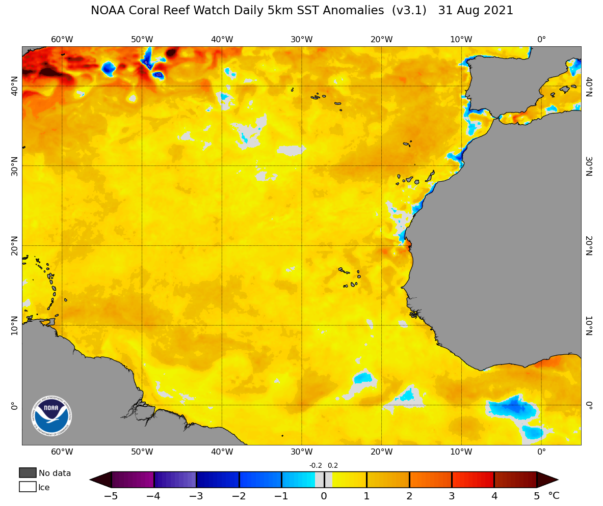
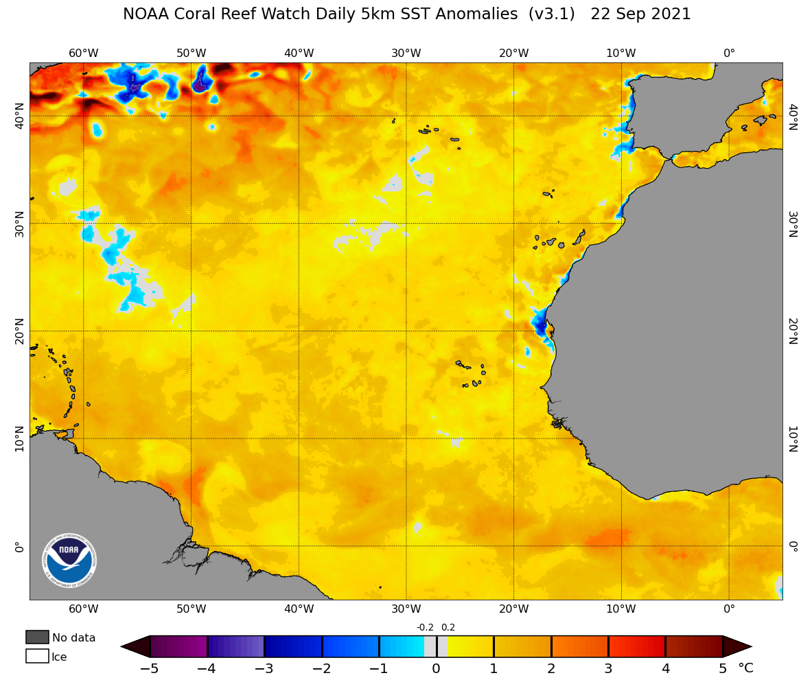
As the above illustrates, Larry and Sam actually formed over cooler-than-average SST in the MDR, and even became major hurricanes while over less-than-optimal SSTs. The Atlantic Niño clearly did not help the MDR as far as SST were concerned, given that NOAA OI anomalies for ASO of 2021 were average or below average across most of the MDR, as the above graphic indicates. Larry and Sam first became tropical storms and intensified into major hurricanes while over less-than-optimal SST in the MDR. Only the extreme eastern and western edges of the MDR featured even a remotely favourable SST profile during the peak months of ASO in 2021. Larry and Sam formed outside those peripheral areas.
2 likes
CVW / MiamiensisWx / Shell Mound
The posts in this forum are NOT official forecasts and should not be used as such. They are just the opinion of the poster and may or may not be backed by sound meteorological data. They are NOT endorsed by any professional institution or STORM2K. For official information, please refer to products from the NHC and NWS.
-
Shell Mound
- Category 5
- Posts: 2432
- Age: 33
- Joined: Thu Sep 07, 2017 3:39 pm
- Location: St. Petersburg, FL → Scandinavia
Re: 2022 indicators: SSTs / SAL / MSLP / shear / steering / instability / images
However, an Atlantic Niño is typically characterised by a cooler-than-average MDR and a warmer-than-average Gulf of Guinea, so the warm SST that immediately preceded Larry and Sam were atypical of the strong Atlantic Niño that was ongoing at the time:

So the Atlantic Niño was arguably a suppressive factor and the occurrence of Larry and Sam was in spite of rather than because of the Atlantic Niño. As mentioned, strong Atlantic Niños coincide with a relatively cool MDR (10°–20°N, 20°–60°W).
1 likes
CVW / MiamiensisWx / Shell Mound
The posts in this forum are NOT official forecasts and should not be used as such. They are just the opinion of the poster and may or may not be backed by sound meteorological data. They are NOT endorsed by any professional institution or STORM2K. For official information, please refer to products from the NHC and NWS.
-
hurricane2025
- Category 1

- Posts: 254
- Joined: Thu Apr 08, 2021 10:36 am
-
cycloneye
- Admin
- Posts: 149696
- Age: 69
- Joined: Thu Oct 10, 2002 10:54 am
- Location: San Juan, Puerto Rico
Re: 2022 indicators: SSTs / SAL / MSLP / shear / steering / instability / images
The big news today is the CPC April Update. Go to the ENSO Thread to see the details.
0 likes
Visit the Caribbean-Central America Weather Thread where you can find at first post web cams,radars
and observations from Caribbean basin members Click Here
and observations from Caribbean basin members Click Here
-
Category5Kaiju
- Category 5
- Posts: 4345
- Joined: Thu Dec 24, 2020 12:45 pm
- Location: Seattle during the summer, Phoenix during the winter
Re: 2022 indicators: SSTs / SAL / MSLP / shear / steering / instability / images
With the most recent ENSO update, it is looking like at least shear-wise, the Atlantic should be favored, particularly with this La Nina having a very high chance of lasting into a third year (and a second year if you consider without a transition to even neutral!). And now it's inevitable and very understandable that most of the discussions will now be heavily focused on the sst anomalies, MJO, dry air, etc.
However, in light of this, I do have a question to pose: does a third year La Nina year necessarily really mean that it cannot be hyperactive or, at least, more active than the previous two seasons? I have definitely seen arguments thrown around that since 2000 was not more active than 1998/1999 that 2022 will follow suit or that there's some aspect of a La Nina that saps warmth and causes the Atlantic to not have as high of a ceiling as the previous seasons. Although I am not exactly sure how valid such thoughts are, as while not third year La Ninas per se, 1933, 1955, 2008, and 2017 show that there definitely are a handful of second La Nina years that ended up being more active ACE-wise than the years before them.
However, in light of this, I do have a question to pose: does a third year La Nina year necessarily really mean that it cannot be hyperactive or, at least, more active than the previous two seasons? I have definitely seen arguments thrown around that since 2000 was not more active than 1998/1999 that 2022 will follow suit or that there's some aspect of a La Nina that saps warmth and causes the Atlantic to not have as high of a ceiling as the previous seasons. Although I am not exactly sure how valid such thoughts are, as while not third year La Ninas per se, 1933, 1955, 2008, and 2017 show that there definitely are a handful of second La Nina years that ended up being more active ACE-wise than the years before them.
0 likes
Unless explicitly stated, all information in my posts is based on my own opinions and observations. Tropical storms and hurricanes can be extremely dangerous. Refer to an accredited weather research agency or meteorologist if you need to make serious decisions regarding an approaching storm.
-
Monsoonjr99
- Tropical Storm
- Posts: 210
- Age: 26
- Joined: Fri Sep 21, 2018 11:22 pm
- Location: Inland Empire, SoCal
Re: 2022 indicators: SSTs / SAL / MSLP / shear / steering / instability / images
Afaik the "suppressive" effects of the Atlantic Nino in 2021 were only applicable to the late season, as by October the ITCZ was too low in latitude to allow waves to develop in the Caribbean. Earlier in the season, it arguably enhanced MDR activity due to low-latitude westerlies generating extra vorticity; a "kick" that may have helped Larry and Sam get going.
5 likes
The posts in this forum are NOT official forecasts and should not be used as such. They are just the opinion of the poster and may or may not be backed by sound meteorological data. They are NOT endorsed by any professional institution or STORM2K. For official information, please refer to products from the NHC and NWS.
Some Californian who codes things and tracks weather.
Kay '22, Hilary '23
Re: 2022 indicators: SSTs / SAL / MSLP / shear / steering / instability / images
Was it really a suppressed ITCZ that limited late season activity last year? From CSU's discussion:
Elevated vertical wind shear persisted across the Caribbean during this time, suppressing Atlantic TC formation.
The primary driver of the increased vertical wind shear in the latter part of 2021 was an anomalous upper-level low across the western Atlantic. This upper-level low and associated enhanced wavebreaking drove increased vertical wind shear across the western Atlantic that suppressed the latter part of the season.
6 likes
-
cycloneye
- Admin
- Posts: 149696
- Age: 69
- Joined: Thu Oct 10, 2002 10:54 am
- Location: San Juan, Puerto Rico
Re: 2022 indicators: SSTs / SAL / MSLP / shear / steering / instability / images
Already a wave train? Looks like the once again active WAM will be a key factor on MDR activity.

7 likes
Visit the Caribbean-Central America Weather Thread where you can find at first post web cams,radars
and observations from Caribbean basin members Click Here
and observations from Caribbean basin members Click Here
-
DorkyMcDorkface

- Category 5
- Posts: 1039
- Age: 28
- Joined: Mon Sep 30, 2019 1:32 pm
- Location: Mid-Atlantic
Re: 2022 indicators: SSTs / SAL / MSLP / shear / steering / instability / images
Monsoonjr99 wrote:Afaik the "suppressive" effects of the Atlantic Nino in 2021 were only applicable to the late season, as by October the ITCZ was too low in latitude to allow waves to develop in the Caribbean. Earlier in the season, it arguably enhanced MDR activity due to low-latitude westerlies generating extra vorticity; a "kick" that may have helped Larry and Sam get going.
Don't forget about Elsa, an extremely anomalous event that likely would not have occurred if there was no Atlantic Niño. A rare Atlantic westerly wind burst birthed by the unusually warm Equatorial Atlantic SSTs helped it get going along with keeping it at a southerly latitude over warmer SSTs and shielding it from early season Saharan air plumes. Like you said, its presence can both be a blessing and a curse when it comes to TC activity, it just depends on the time of year really.
2 likes
Please note the thoughts expressed by this account are solely those of the user and are from a hobbyist perspective. For more comprehensive analysis, consult an actual professional meteorologist or meteorological agency.
Floyd 1999 | Isabel 2003 | Hanna 2008 | Irene 2011 | Sandy 2012 | Isaias 2020
-
Iceresistance

- Category 5
- Posts: 9605
- Age: 22
- Joined: Sat Oct 10, 2020 9:45 am
- Location: Tecumseh, OK/Norman, OK
Re: 2022 indicators: SSTs / SAL / MSLP / shear / steering / instability / images
cycloneye wrote:Already a wave train? Looks like the once again active WAM will be a key factor on MDR activity.
https://i.imgur.com/KjuxtPB.png
Was there one like that in the past 2 Aprils?
1 likes
Bill 2015 & Beta 2020
Winter 2020-2021
All observations are in Tecumseh, OK unless otherwise noted.
Winter posts are focused mainly for Oklahoma & Texas.
Take any of my forecasts with a grain of salt, refer to the NWS, SPC, and NHC for official information
Never say Never with weather! Because ANYTHING is possible!
Winter 2020-2021
All observations are in Tecumseh, OK unless otherwise noted.
Winter posts are focused mainly for Oklahoma & Texas.
Take any of my forecasts with a grain of salt, refer to the NWS, SPC, and NHC for official information
Never say Never with weather! Because ANYTHING is possible!
-
Category5Kaiju
- Category 5
- Posts: 4345
- Joined: Thu Dec 24, 2020 12:45 pm
- Location: Seattle during the summer, Phoenix during the winter
Re: 2022 indicators: SSTs / SAL / MSLP / shear / steering / instability / images
cycloneye wrote:Already a wave train? Looks like the once again active WAM will be a key factor on MDR activity.
https://i.imgur.com/KjuxtPB.png
Yeah, just by looking at that, this season seems very eager to begin. Of course, we won't be getting Cape Verde storms anytime soon, but combine an active WAM with a continuing La Nina, and you get the basic recipe for above average activity. How active is the burning question at this point.
0 likes
Unless explicitly stated, all information in my posts is based on my own opinions and observations. Tropical storms and hurricanes can be extremely dangerous. Refer to an accredited weather research agency or meteorologist if you need to make serious decisions regarding an approaching storm.
-
Kingarabian

- S2K Supporter

- Posts: 16377
- Joined: Sat Aug 08, 2009 3:06 am
- Location: Honolulu, Hawaii
Re: 2022 indicators: SSTs / SAL / MSLP / shear / steering / instability / images
cycloneye wrote:Already a wave train? Looks like the once again active WAM will be a key factor on MDR activity.
https://i.imgur.com/KjuxtPB.png
Looks like they're disturbances part of the monsoon trough but could easily split and become AEW's.
0 likes
RIP Kobe Bryant
-
NotSparta

- Professional-Met

- Posts: 1677
- Age: 24
- Joined: Fri Aug 18, 2017 8:24 am
- Location: Naples, FL
- Contact:
Re: 2022 indicators: SSTs / SAL / MSLP / shear / steering / instability / images
cycloneye wrote:Already a wave train? Looks like the once again active WAM will be a key factor on MDR activity.
https://i.imgur.com/KjuxtPB.png
Looking like another strong WAM year. Really not a surprise. Just continues the streaks and some of the early conditions suggest it won't be too different from the past few years
6 likes
This post was probably an opinion of mine, and in no way is official. Please refer to http://www.hurricanes.gov for official tropical analysis and advisories.
My website, with lots of tropical wx graphics, including satellite and recon: http://cyclonicwx.com
My website, with lots of tropical wx graphics, including satellite and recon: http://cyclonicwx.com
Who is online
Users browsing this forum: Google [Bot] and 201 guests