Texas Spring 2022
Moderator: S2k Moderators
Forum rules

The posts in this forum are NOT official forecast and should not be used as such. They are just the opinion of the poster and may or may not be backed by sound meteorological data. They are NOT endorsed by any professional institution or STORM2K.


Re: Texas Spring 2022
Storms firing to the north and west. The cell moving towards OKC looks like it wants to drop something.
0 likes
The above post and any post by Ntxw is NOT an official forecast and should not be used as such. It is just the opinion of the poster and may or may not be backed by sound meteorological data. It is NOT endorsed by any professional institution including Storm2k. For official information, please refer to NWS products.
Help support Storm2K!
Re: Texas Spring 2022
There it is.
Tornado Warning
OKC017-027-051-087-109-240045-
/O.NEW.KOUN.TO.W.0013.220424T0003Z-220424T0045Z/
BULLETIN - EAS ACTIVATION REQUESTED
Tornado Warning
National Weather Service Norman OK
703 PM CDT Sat Apr 23 2022
The National Weather Service in Norman has issued a
* Tornado Warning for...
Northeastern Grady County in central Oklahoma...
Southwestern Oklahoma County in central Oklahoma...
Northwestern Cleveland County in central Oklahoma...
Southeastern Canadian County in central Oklahoma...
Northwestern McClain County in central Oklahoma...
* Until 745 PM CDT.
* At 703 PM CDT, a severe thunderstorm capable of producing a tornado
was located 5 miles west of Tuttle, moving east at 30 mph.
HAZARD...Tornado and golf ball size hail.
SOURCE...Radar indicated rotation.
IMPACT...Flying debris will be dangerous to those caught without
shelter. Mobile homes will be damaged or destroyed.
Damage to roofs, windows, and vehicles will occur. Tree
damage is likely.
* Locations impacted include...
Oklahoma City, Moore, Del City, Newcastle, Yukon, Bethany, Mustang,
Warr Acres, The Village, Tuttle, Nichols Hills, Valley Brook,
Woodlawn Park and Smith Village.
This includes the following highways...
Interstate 35 between mile markers 117 and 130.
Interstate 40 between mile markers 137 and 155.
Interstate 44 between mile markers 109 and 128.
Interstate 240 between mile markers 1 and 8.
PRECAUTIONARY/PREPAREDNESS ACTIONS...
TAKE COVER NOW! Move to a storm shelter, safe room or an interior
room on the lowest floor of a sturdy building. Avoid windows. If you
are outdoors, in a mobile home, or in a vehicle, move to the closest
substantial shelter and protect yourself from flying debris.
&&
LAT...LON 3524 9789 3541 9790 3559 9755 3546 9743
3534 9741
TIME...MOT...LOC 0003Z 250DEG 26KT 3534 9784
TORNADO...RADAR INDICATED
MAX HAIL SIZE...1.75 IN
0 likes
The above post and any post by Ntxw is NOT an official forecast and should not be used as such. It is just the opinion of the poster and may or may not be backed by sound meteorological data. It is NOT endorsed by any professional institution including Storm2k. For official information, please refer to NWS products.
Help support Storm2K!
Help support Storm2K!
-
ElectricStorm

- Category 5

- Posts: 5145
- Age: 25
- Joined: Tue Aug 13, 2019 11:23 pm
- Location: Norman, OK
Re: Texas Spring 2022
Yeah this event was a bit tense for me as that tor warned cell earlier passed right over some of my relatives and for a while there it looked like it had some serious potential but thankfully that didn't happen. The supercell to the south of that one also looked like it was wrapping up but it didn't last long and never went tor warned as it passed over me. This event seems like it was one or two small ingredients away from being a major tornado outbreak but luckily that didn't happen. Should have a second round of storms coming through here later tonight but they will likely have lesser tornado potential.
1 likes
B.S Meteorology, University of Oklahoma '25
Please refer to the NHC, NWS, or SPC for official information.
Please refer to the NHC, NWS, or SPC for official information.
-
bubba hotep

- S2K Supporter

- Posts: 6014
- Joined: Wed Dec 28, 2016 1:00 am
- Location: Collin County Texas
Re: Texas Spring 2022
Looks like the storms overnight in OK might have produced enough of a cold pool to shift the boundary SE of what models were expecting for today. This shows up in the 12z HRRR with a bump SE of the axis of heaviest rainfall. It's not huge, but it shifts DFW from 0.5-1" coverage to 1-3", esp. the northern counties.
0 likes
Winter time post are almost exclusively focused on the DFW area.
-
Haris

- Category 5
- Posts: 1814
- Joined: Mon Nov 27, 2017 8:19 pm
- Location: ( Bee Cave) West Austin, Texas
Re: Texas Spring 2022
bubba hotep wrote:Looks like the storms overnight in OK might have produced enough of a cold pool to shift the boundary SE of what models were expecting for today. This shows up in the 12z HRRR with a bump SE of the axis of heaviest rainfall. It's not huge, but it shifts DFW from 0.5-1" coverage to 1-3", esp. the northern counties.
Yep add 12z NAM to that
0 likes
Weather geek and a storm spotter in West Austin. Not a degreed meteorologist. Big snow fan. Love rain and cold! Despise heat!
-
Iceresistance

- Category 5
- Posts: 9581
- Age: 22
- Joined: Sat Oct 10, 2020 9:45 am
- Location: Tecumseh, OK/Norman, OK
Re: Texas Spring 2022
Haris wrote:bubba hotep wrote:Looks like the storms overnight in OK might have produced enough of a cold pool to shift the boundary SE of what models were expecting for today. This shows up in the 12z HRRR with a bump SE of the axis of heaviest rainfall. It's not huge, but it shifts DFW from 0.5-1" coverage to 1-3", esp. the northern counties.
Yep add 12z NAM to that
HRRR also has a LOT of rainfall for Southern Oklahoma & Northern Texas in the next 12 hours.
The WPC is thinking that the Southeastern 1/3rd of Texas will get some really good rainfall Tomorrow
1 likes
Bill 2015 & Beta 2020
Winter 2020-2021
All observations are in Tecumseh, OK unless otherwise noted.
Winter posts are focused mainly for Oklahoma & Texas.
Take any of my forecasts with a grain of salt, refer to the NWS, SPC, and NHC for official information
Never say Never with weather! Because ANYTHING is possible!
Winter 2020-2021
All observations are in Tecumseh, OK unless otherwise noted.
Winter posts are focused mainly for Oklahoma & Texas.
Take any of my forecasts with a grain of salt, refer to the NWS, SPC, and NHC for official information
Never say Never with weather! Because ANYTHING is possible!
-
HockeyTx82
- S2K Supporter
- Posts: 2791
- Joined: Tue Oct 27, 2009 11:17 am
- Location: Ponder, TX
Re: Texas Spring 2022
1 likes
Don't hold me accountable for anything I post on this forum. Leave the real forecasting up to the professionals.
Location: Ponder, TX (all observation posts are this location unless otherwise noted)
Location: Ponder, TX (all observation posts are this location unless otherwise noted)
-
rwfromkansas
- Category 5
- Posts: 3032
- Joined: Sat Aug 27, 2005 12:47 am
- Location: North Fort Worth
Re: Texas Spring 2022
Latest runs are great for me. It seems they are firing not just a little but quite a bit closer to DFW than expected this morning.
0 likes
-
bubba hotep
- S2K Supporter
- Posts: 6014
- Joined: Wed Dec 28, 2016 1:00 am
- Location: Collin County Texas
Re: Texas Spring 2022
Looks like they have expanded the flood watch south by a row of counties.
0 likes
Winter time post are almost exclusively focused on the DFW area.
Re: Texas Spring 2022
Pwats are healthy, dews been elevated for 3-4 days and storm initiation is enough west with shifting boundaries we're more primed to overachieve in this set up, nice for a change. Moisture transport is coming from the gulf.
2 likes
The above post and any post by Ntxw is NOT an official forecast and should not be used as such. It is just the opinion of the poster and may or may not be backed by sound meteorological data. It is NOT endorsed by any professional institution including Storm2k. For official information, please refer to NWS products.
Help support Storm2K!
Help support Storm2K!
-
bubba hotep
- S2K Supporter
- Posts: 6014
- Joined: Wed Dec 28, 2016 1:00 am
- Location: Collin County Texas
Re: Texas Spring 2022
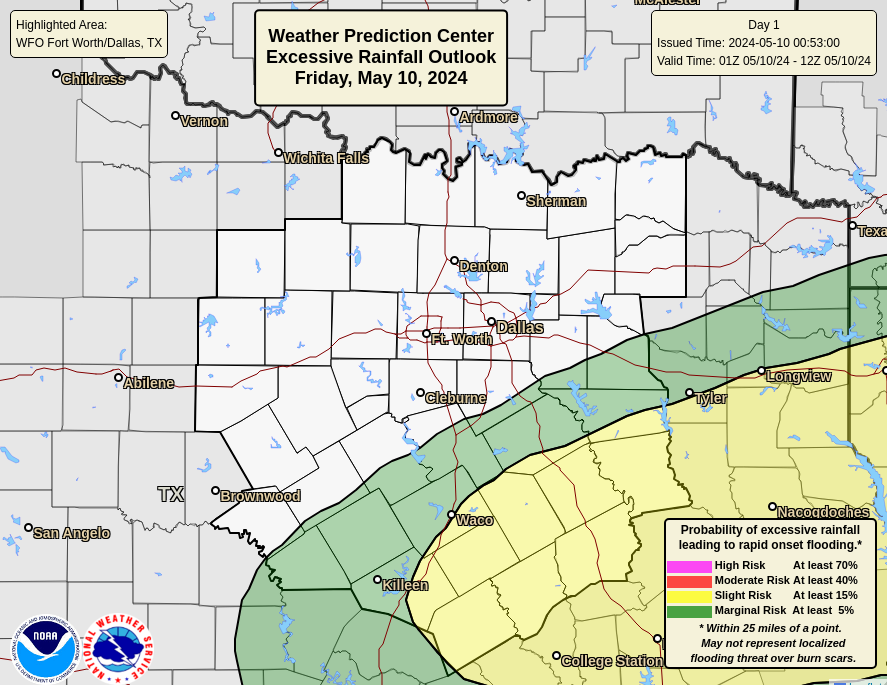
Updated outlook from WPC
0 likes
Winter time post are almost exclusively focused on the DFW area.
-
bubba hotep
- S2K Supporter
- Posts: 6014
- Joined: Wed Dec 28, 2016 1:00 am
- Location: Collin County Texas
Re: Texas Spring 2022

Mesoscale Precipitation Discussion 0133
NWS Weather Prediction Center College Park MD
449 PM EDT Sun Apr 24 2022
Areas affected...North TX, Eastern and Southeastern OK, far
northwest AR
Concerning...Heavy rainfall...Flash flooding possible
Valid 242048Z - 250200Z
Summary...Showers and thunderstorms developing along a slow moving
front will continue to train to the northeast through this
evening. Rainfall rates may briefly exceed 2"/hr at times,
producing 1-3" of rain with local maxima to 4". Flash flooding is
possible.
Discussion...The regional radar mosaic this aftn shows a large
area of showers with embedded thunderstorms stretching along a
slow moving front from far NE Oklahoma into parts of N Texas west
of Dallas-Fort Worth. Recent rain rate estimates from KFWS have
exceeded 1.5"/hr, and daily rainfall as measured by regional
mesonets has been more than 3 inches in a few locations. This rain
is occurring atop very dry soils due to AHPS 14-day rainfall that
is generally just 10% of normal leading to 40cm soil moisture
according to NASA SPoRT that is in the bottom 10th percentile.
This has so far limited the flooding across the region this
morning, but is priming the soils for an increased flash flood
risk.
As the aftn progresses, thunderstorms are likely to expand and
intensify. A mid-level longwave trough axis over the Four Corners
will maintain deep SW flow into the Southern Plains, through which
embedded shortwave impulses will lift northeast. Additionally, a
strengthening upper jet streak will place increasing RRQ
diffluence atop the region, and the overlap of convergence along
the front with PVA and upper diffluence will produce increasing
deep layer ascent. This forcing will impinge upon favorable
thermodynamics characterized by MUCape forecast to reach 1000-2000
J/kg and PWs surging towards 1.75", around the 90th percentile for
the date. These favorable thermodynamics will advect northward
into the front on a LLJ which should locally back to the south at
20-30kts, becoming more orthogonal to the boundary for better
ascent. This suggests that storms will likely initiate on the
boundary and lift northward, with the heaviest rainfall expected
along and just north of the front. Rain rates within this
expanding convection are progged by the HREF to reach 2"/hr, which
could exceed the 1-hr FFG.
Deep SW flow will remain parallel to the front, so despite 0-6km
winds that will be 30-40 kts, training of echoes is likely which
could enhance rainfall duration, or produce several rounds of of
heavy rain. The most robust overall convection should gradually
shift ENE with time, but regeneration back into the better
instability and along the front has the potential to produce
longer duration heavy rainfall anywhere within the MPD area. The
dry soils will continue to somewhat limit the flash flood threat,
but where training occurs, locally 4" of rainfall could occur,
leading to possible flash flooding.
Weiss
ATTN...WFO...FWD...LZK...OUN...SGF...SHV...SJT...TSA...
ATTN...RFC...ABRFC...LMRFC...WGRFC...NWC...
0 likes
Winter time post are almost exclusively focused on the DFW area.
Re: Texas Spring 2022
Radar has been teasing me all day. I can't wait for a large blob of rain to park itself over DFW. Let's go already!!!
1 likes
-
Brent
- S2K Supporter
- Posts: 38737
- Age: 37
- Joined: Sun May 16, 2004 10:30 pm
- Location: Tulsa Oklahoma
- Contact:
Re: Texas Spring 2022
Been a nice rainy day here. Haven't had many of these recently
2 likes
#neversummer
-
bubba hotep
- S2K Supporter
- Posts: 6014
- Joined: Wed Dec 28, 2016 1:00 am
- Location: Collin County Texas
Re: Texas Spring 2022
Few showers finally starting to push into western Tarrant County. Overall, coverage and intensity hasn't really been there today as you move south from the Red River counties.
0 likes
Winter time post are almost exclusively focused on the DFW area.
Re: Texas Spring 2022
gpsnowman wrote:Radar has been teasing me all day. I can't wait for a large blob of rain to park itself over DFW. Let's go already!!!
Been waiting to see it happen. Deep down inside with ongoing drought just nerve racking because you know it could find a way to rob it.
0 likes
The above post and any post by Ntxw is NOT an official forecast and should not be used as such. It is just the opinion of the poster and may or may not be backed by sound meteorological data. It is NOT endorsed by any professional institution including Storm2k. For official information, please refer to NWS products.
Help support Storm2K!
Help support Storm2K!
-
txtwister78

- Category 5
- Posts: 2176
- Joined: Wed Jan 30, 2019 12:56 pm
- Location: San Antonio
Re: Texas Spring 2022
Looks like HRRR is handling this the best in the short term...keeping the bulk of the heaviest/widespread rainfall north of DFW closer to the red river. NAM has really been all over the place. Good news for tomorrow is most models seem to be pointing to some beneficial rain for the drought-stricken areas of SC TX (SA region) and across the southern Edwards Plateau. We shall see.
2 likes
-
rwfromkansas
- Category 5
- Posts: 3032
- Joined: Sat Aug 27, 2005 12:47 am
- Location: North Fort Worth
Re: Texas Spring 2022
Very little rain so far. Not filling in. Got .20 at least. I think the big batch is still to come.
0 likes
-
bubba hotep
- S2K Supporter
- Posts: 6014
- Joined: Wed Dec 28, 2016 1:00 am
- Location: Collin County Texas
Re: Texas Spring 2022
Wow... monumental bust incoming? Storms are firing in the SW and will build eastward tonight and cut off the moisture flow into N. TX. There was still some significant CIN on the 00z FWD sounding, which likely kept a solid bath of storms from firing along the front. There is still a brief window for some rain to form behind the front but not really seeing any signs that rain is building southward behind the front.
0 likes
Winter time post are almost exclusively focused on the DFW area.
Return to “USA & Caribbean Weather”
Who is online
Users browsing this forum: A1A, CaptinCrunch, Cpv17, Stratton23, txtwister78 and 176 guests