2022 Indicators (SSTs/SAL/MSLP/Shear/Steering/Instability) and >Day 16 Models
Moderator: S2k Moderators
Forum rules

The posts in this forum are NOT official forecasts and should not be used as such. They are just the opinion of the poster and may or may not be backed by sound meteorological data. They are NOT endorsed by any professional institution or STORM2K. For official information, please refer to products from the National Hurricane Center and National Weather Service.
-
mixedDanilo.E
- Tropical Storm

- Posts: 117
- Joined: Sun Nov 21, 2021 8:00 am
- Location: NY
Re: 2022 indicators: SSTs / SAL / MSLP / shear / steering / instability / images
The weak trade winds are very prevenlant in the northern MDR tho throughout the entire run so idk if we will see a pause in warming in the northern MDR - the NAO is still very negative and pressure patterns across the Atlantic are very weak still - honestly I think the trades being hinted might be a weird response to som stuff that won’t even have implications on the MDR. So I don’t see Atlantic warming stopping at all at least in the northern MDR.
0 likes
-
Yellow Evan

- Professional-Met

- Posts: 16257
- Age: 27
- Joined: Fri Jul 15, 2011 12:48 pm
- Location: Henderson, Nevada/Honolulu, HI
- Contact:
-
Kingarabian

- S2K Supporter

- Posts: 16381
- Joined: Sat Aug 08, 2009 3:06 am
- Location: Honolulu, Hawaii
Re: 2022 indicators: SSTs / SAL / MSLP / shear / steering / instability / images
I wouldn't put too much stock in the GFS and its enhanced MDR trades solution until proven otherwise.
The 90 day CFS agrees with the EPS. The CFS bands from the EQ to 7.5N/7.5N to 15N show very weak trades or even raw westerlies over the MDR east of 40W. Trades will be enhanced over the ECaribbean though, but that is to be expected.


The 90 day CFS agrees with the EPS. The CFS bands from the EQ to 7.5N/7.5N to 15N show very weak trades or even raw westerlies over the MDR east of 40W. Trades will be enhanced over the ECaribbean though, but that is to be expected.
10 likes
RIP Kobe Bryant
-
DorkyMcDorkface

- Category 5

- Posts: 1045
- Age: 28
- Joined: Mon Sep 30, 2019 1:32 pm
- Location: Mid-Atlantic
Re: 2022 indicators: SSTs / SAL / MSLP / shear / steering / instability / images
Check out that warm patch near 25N/35W migrating southward, wonder if we could be starting a transition away from the current EOF2 +AMO phase we're in into something more classic-looking (EOF1) thanks to the trade winds slackening.


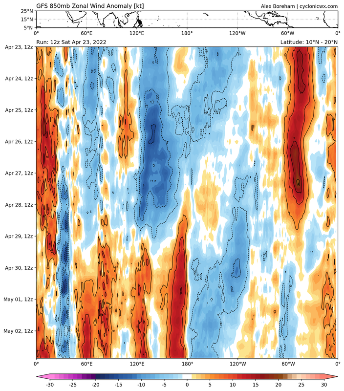
If the GFS is correct the strongest westerly anoms haven't even started yet.

If the GFS is correct the strongest westerly anoms haven't even started yet.
8 likes
Please note the thoughts expressed by this account are solely those of the user and are from a hobbyist perspective. For more comprehensive analysis, consult an actual professional meteorologist or meteorological agency.
Floyd 1999 | Isabel 2003 | Hanna 2008 | Irene 2011 | Sandy 2012 | Isaias 2020

Re: 2022 indicators: SSTs / SAL / MSLP / shear / steering / instability / images
those westerlies will be short-lived based on model projections
0 likes
-
AlphaToOmega
- Category 5
- Posts: 1448
- Joined: Sat Jun 26, 2021 10:51 am
- Location: Somewhere in Massachusetts
Re: 2022 indicators: SSTs / SAL / MSLP / shear / steering / instability / images
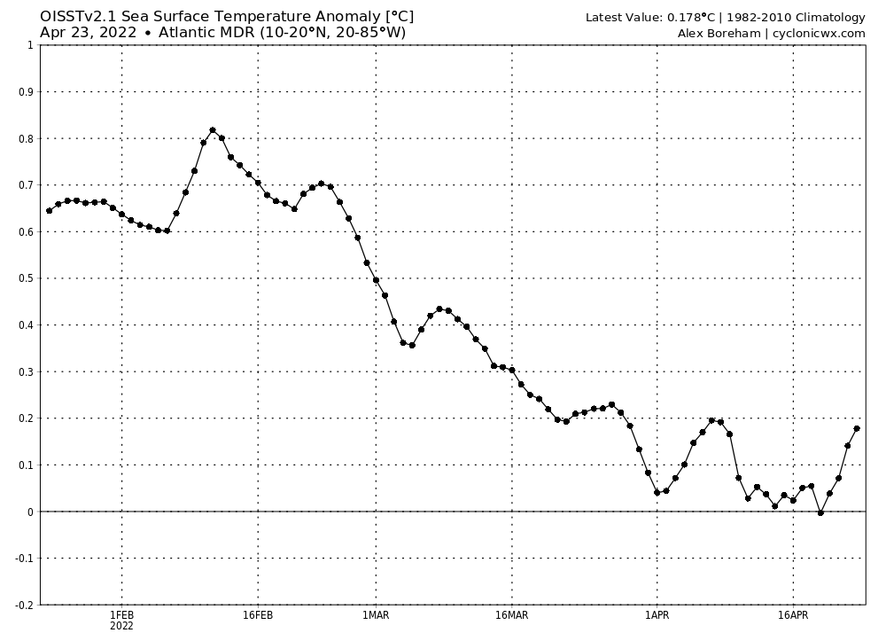
The MDR has warmed to 0.178 C above-average today, and further warming is expected until April 28.
1 likes
-
NotSparta

- Professional-Met
- Posts: 1677
- Age: 24
- Joined: Fri Aug 18, 2017 8:24 am
- Location: Naples, FL
- Contact:
Re: 2022 indicators: SSTs / SAL / MSLP / shear / steering / instability / images
DorkyMcDorkface wrote:Check out that warm patch near 25N/35W migrating southward, wonder if we could be starting a transition away from the current EOF2 +AMO phase we're in into something more classic-looking (EOF1) thanks to the trade winds slackening.
https://i.ibb.co/jV99wCT/crw-ssta-tropatl-2.gif
https://i.ibb.co/c300fPs/crw-sstac-tropatl.gif
If the GFS is correct the strongest westerly anoms haven't even started yet.
https://i.ibb.co/phwySYb/gfs-15-N-hov-uanom-2022042306.png
That area is even more pronounced on OISST

8 likes
This post was probably an opinion of mine, and in no way is official. Please refer to http://www.hurricanes.gov for official tropical analysis and advisories.
My website, with lots of tropical wx graphics, including satellite and recon: http://cyclonicwx.com
My website, with lots of tropical wx graphics, including satellite and recon: http://cyclonicwx.com
-
Category5Kaiju

- Category 5
- Posts: 4347
- Joined: Thu Dec 24, 2020 12:45 pm
- Location: Seattle during the summer, Phoenix during the winter
Re: 2022 indicators: SSTs / SAL / MSLP / shear / steering / instability / images
NotSparta wrote:DorkyMcDorkface wrote:Check out that warm patch near 25N/35W migrating southward, wonder if we could be starting a transition away from the current EOF2 +AMO phase we're in into something more classic-looking (EOF1) thanks to the trade winds slackening.
https://i.ibb.co/jV99wCT/crw-ssta-tropatl-2.gif
https://i.ibb.co/c300fPs/crw-sstac-tropatl.gif
If the GFS is correct the strongest westerly anoms haven't even started yet.
https://i.ibb.co/phwySYb/gfs-15-N-hov-uanom-2022042306.png
That area is even more pronounced on OISST
https://cdn.discordapp.com/attachments/661421636003823632/967482895021273138/mdr_warming_2022.gif
Wow, that's already looking pretty remarkable for a warm-up. If the GFS is right and we have yet to see the strong westerlies, this is going to be quite interesting to watch.
0 likes
Unless explicitly stated, all information in my posts is based on my own opinions and observations. Tropical storms and hurricanes can be extremely dangerous. Refer to an accredited weather research agency or meteorologist if you need to make serious decisions regarding an approaching storm.
-
NotSparta
- Professional-Met
- Posts: 1677
- Age: 24
- Joined: Fri Aug 18, 2017 8:24 am
- Location: Naples, FL
- Contact:
Re: 2022 indicators: SSTs / SAL / MSLP / shear / steering / instability / images
Category5Kaiju wrote:NotSparta wrote:DorkyMcDorkface wrote:Check out that warm patch near 25N/35W migrating southward, wonder if we could be starting a transition away from the current EOF2 +AMO phase we're in into something more classic-looking (EOF1) thanks to the trade winds slackening.
https://i.ibb.co/jV99wCT/crw-ssta-tropatl-2.gif
https://i.ibb.co/c300fPs/crw-sstac-tropatl.gif
If the GFS is correct the strongest westerly anoms haven't even started yet.
https://i.ibb.co/phwySYb/gfs-15-N-hov-uanom-2022042306.png
That area is even more pronounced on OISST
https://cdn.discordapp.com/attachments/661421636003823632/967482895021273138/mdr_warming_2022.gif
Wow, that's already looking pretty remarkable for a warm-up. If the GFS is right and we have yet to see the strong westerlies, this is going to be quite interesting to watch.
I wonder what happens when the near normal/stronger than usual trades reappear. Does it try to sink back towards where it is? Or does it just kind of stop warming but not really cool off
1 likes
This post was probably an opinion of mine, and in no way is official. Please refer to http://www.hurricanes.gov for official tropical analysis and advisories.
My website, with lots of tropical wx graphics, including satellite and recon: http://cyclonicwx.com
My website, with lots of tropical wx graphics, including satellite and recon: http://cyclonicwx.com
Re: 2022 indicators: SSTs / SAL / MSLP / shear / steering / instability / images
cooling will likely resume when those easterlies come back
0 likes
-
cycloneye

- Admin

- Posts: 149730
- Age: 69
- Joined: Thu Oct 10, 2002 10:54 am
- Location: San Juan, Puerto Rico
Re: 2022 indicators: SSTs / SAL / MSLP / shear / steering / instability / images
Good discussions going on in twitter about the MDR and the warming.
https://twitter.com/dmorris9661/status/1517868722962247681
https://twitter.com/AndyHazelton/status/1517880010786459655
https://twitter.com/dmorris9661/status/1517899201736282113
https://twitter.com/DCAreaWx/status/1517883317508616193
https://twitter.com/DCAreaWx/status/1517905059069272065
https://twitter.com/dmorris9661/status/1517907556609396737
https://twitter.com/cyclonicwx/status/1517950326657138688
https://twitter.com/dmorris9661/status/1517982075307147271
5 likes
Visit the Caribbean-Central America Weather Thread where you can find at first post web cams,radars
and observations from Caribbean basin members Click Here
and observations from Caribbean basin members Click Here
-
SFLcane

- S2K Supporter
- Posts: 10281
- Age: 48
- Joined: Sat Jun 05, 2010 1:44 pm
- Location: Lake Worth Florida
Re: 2022 indicators: SSTs / SAL / MSLP / shear / steering / instability / images
This certainly goes with Phil’s and 57’s idea of a super season oh boy. 
https://twitter.com/andyhazelton/status/1517986875637698568
https://twitter.com/andyhazelton/status/1517986875637698568
0 likes
-
NotSparta
- Professional-Met
- Posts: 1677
- Age: 24
- Joined: Fri Aug 18, 2017 8:24 am
- Location: Naples, FL
- Contact:
Re: 2022 indicators: SSTs / SAL / MSLP / shear / steering / instability / images
SFLcane wrote:This certainly goes with Phil’s and 57’s idea of a super season oh boy.
https://twitter.com/andyhazelton/status/1517986875637698568?s=21&t=WZ9zMMofShUkIsf_Vszbuw
Then there's this. We'll see which wins in the end
https://twitter.com/AndyHazelton/status/1517975684991406082
1 likes
This post was probably an opinion of mine, and in no way is official. Please refer to http://www.hurricanes.gov for official tropical analysis and advisories.
My website, with lots of tropical wx graphics, including satellite and recon: http://cyclonicwx.com
My website, with lots of tropical wx graphics, including satellite and recon: http://cyclonicwx.com
-
AlphaToOmega
- Category 5
- Posts: 1448
- Joined: Sat Jun 26, 2021 10:51 am
- Location: Somewhere in Massachusetts
Re: 2022 indicators: SSTs / SAL / MSLP / shear / steering / instability / images
Interestingly, the models seem to be backing off of a sustained period of strong trade winds. MDR warming is going to halt on April 29, but what happens after that is still an open question. If the trade winds go back to being weak, warming will continue (warming will obviously be slower than it is right now because the anomalies will not be nearly as large), but if the trade winds stay strong, two things could happen: the MDR could cool back to pre-negative-NAO levels, or the MDR could remain slightly above-average but not change in SSTAs.
0 likes
-
Kingarabian
- S2K Supporter
- Posts: 16381
- Joined: Sat Aug 08, 2009 3:06 am
- Location: Honolulu, Hawaii
Re: 2022 indicators: SSTs / SAL / MSLP / shear / steering / instability / images
It's also better not to monitor warming only a daily basis. Have to go week by week. There are times when modeled trades fail to cool waters and vice versa.
9 likes
RIP Kobe Bryant
-
skyline385

- Category 5
- Posts: 2728
- Age: 35
- Joined: Wed Aug 26, 2020 11:15 pm
- Location: Houston TX
Re: 2022 indicators: SSTs / SAL / MSLP / shear / steering / instability / images
SFLcane wrote:This certainly goes with Phil’s and 57’s idea of a super season oh boy.
https://twitter.com/andyhazelton/status/1517986875637698568
Let's wait for Phil to officially declare a hyperactive season first? Also has 57 said anywhere that he also thinks it's going to be a hyperactive season, i only read his post sharing his discussion with Phil.
0 likes
-
DorkyMcDorkface
- Category 5
- Posts: 1045
- Age: 28
- Joined: Mon Sep 30, 2019 1:32 pm
- Location: Mid-Atlantic
Re: 2022 indicators: SSTs / SAL / MSLP / shear / steering / instability / images
skyline385 wrote:SFLcane wrote:This certainly goes with Phil’s and 57’s idea of a super season oh boy.
https://twitter.com/andyhazelton/status/1517986875637698568?s=21&t=WZ9zMMofShUkIsf_Vszbuw
Let's wait for Phil to officially declare a hyperactive season first? Also has 57 said anywhere that he also thinks it's going to be a hyperactive season, i only read his post sharing his discussion with Phil.
Pretty sure he was referring to this post.
0 likes
Please note the thoughts expressed by this account are solely those of the user and are from a hobbyist perspective. For more comprehensive analysis, consult an actual professional meteorologist or meteorological agency.
Floyd 1999 | Isabel 2003 | Hanna 2008 | Irene 2011 | Sandy 2012 | Isaias 2020
-
NotSparta
- Professional-Met
- Posts: 1677
- Age: 24
- Joined: Fri Aug 18, 2017 8:24 am
- Location: Naples, FL
- Contact:
Re: 2022 indicators: SSTs / SAL / MSLP / shear / steering / instability / images
DorkyMcDorkface wrote:skyline385 wrote:SFLcane wrote:This certainly goes with Phil’s and 57’s idea of a super season oh boy.
https://twitter.com/andyhazelton/status/1517986875637698568?s=21&t=WZ9zMMofShUkIsf_Vszbuw
Let's wait for Phil to officially declare a hyperactive season first? Also has 57 said anywhere that he also thinks it's going to be a hyperactive season, i only read his post sharing his discussion with Phil.
Pretty sure he was referring to this post.
Besides technically CSU already explicitly forecast a hyperactive season, though borderline
1 likes
This post was probably an opinion of mine, and in no way is official. Please refer to http://www.hurricanes.gov for official tropical analysis and advisories.
My website, with lots of tropical wx graphics, including satellite and recon: http://cyclonicwx.com
My website, with lots of tropical wx graphics, including satellite and recon: http://cyclonicwx.com
-
skyline385
- Category 5
- Posts: 2728
- Age: 35
- Joined: Wed Aug 26, 2020 11:15 pm
- Location: Houston TX
2022 indicators: SSTs / SAL / MSLP / shear / steering / instability / images
NotSparta wrote:DorkyMcDorkface wrote:skyline385 wrote:Let's wait for Phil to officially declare a hyperactive season first? Also has 57 said anywhere that he also thinks it's going to be a hyperactive season, i only read his post sharing his discussion with Phil.
Pretty sure he was referring to this post.
Besides technically CSU already explicitly forecast a hyperactive season, though borderline
Don't want to be pedantic but CSU explicitly forecast an above-average season not hyperactive just yet. Yes it on the higher end of above-average but it's not a hyperactive prediction.
And yea that's the wxman post i was talking about, in it he only mentions that Phil is going to revise his numbers. He didn't talk about his own numbers in that post which is what i was asking about.
0 likes
-
skyline385
- Category 5
- Posts: 2728
- Age: 35
- Joined: Wed Aug 26, 2020 11:15 pm
- Location: Houston TX
Re: 2022 indicators: SSTs / SAL / MSLP / shear / steering / instability / images
Last edited by skyline385 on Sun Apr 24, 2022 3:39 am, edited 1 time in total.
1 likes
Who is online
Users browsing this forum: Kingarabian and 129 guests