2022 Indicators (SSTs/SAL/MSLP/Shear/Steering/Instability) and >Day 16 Models

This is the general tropical discussion area. Anyone can take their shot at predicting a storms path.

Moderator: S2k Moderators

Forum rules

The posts in this forum are NOT official forecasts and should not be used as such. They are just the opinion of the poster and may or may not be backed by sound meteorological data. They are NOT endorsed by any professional institution or STORM2K. For official information, please refer to products from the National Hurricane Center and National Weather Service.

Help Support Storm2K
Message
Author
User avatar
DorkyMcDorkface
Category 3
Category 3
Posts: 888
Age: 27
Joined: Mon Sep 30, 2019 1:32 pm
Location: Mid-Atlantic

Re: 2022 indicators: SSTs / SAL / MSLP / shear / steering / instability / images

#681 Postby DorkyMcDorkface » Fri May 06, 2022 5:02 pm


Probably less in the way of stability issues this year if it continues to be less prominent.
1 likes   
Please note the thougths expressed by this account are solely those of the user and are from a hobbyist perspective. For more comprehensive analysis, consult an actual professional meteorologist or meteorology agency.


Floyd 1999 | Isabel 2003 | Hanna 2008 | Irene 2011 | Sandy 2012 | Isaias 2020

AlphaToOmega
Category 5
Category 5
Posts: 1448
Joined: Sat Jun 26, 2021 10:51 am
Location: Somewhere in Massachusetts

Re: 2022 indicators: SSTs / SAL / MSLP / shear / steering / instability / images

#682 Postby AlphaToOmega » Sat May 07, 2022 6:02 am

There is currently a WWB in the Eastern Pacific, which might bring us into a La Nina Modoki temporarily. You can already see this WWB chipping away at the Nino 1+2 cold anomalies.

Image

Image

Image
1 likes   

User avatar
Category5Kaiju
Category 5
Category 5
Posts: 4097
Joined: Thu Dec 24, 2020 12:45 pm
Location: Seattle

Re: 2022 indicators: SSTs / SAL / MSLP / shear / steering / instability / images

#683 Postby Category5Kaiju » Sat May 07, 2022 8:26 am

AlphaToOmega wrote:There is currently a WWB in the Eastern Pacific, which might bring us into a La Nina Modoki temporarily. You can already see this WWB chipping away at the Nino 1+2 cold anomalies.

https://i.postimg.cc/jStTS7LZ/gfs-0-N-hov-uanom-2022050700.png

https://i.postimg.cc/VsJnKSsG/ssta-global-20220430.png

https://i.postimg.cc/kDrncYMm/ssta-global-20220506.png


Not quite sure if we can term this La Nina a "Modoki" per se as I think that criteria must last multiple months, and typically speaking a La Nina Modoki is associated with a dearth of tropical cyclones in the Arabian Sea but plenty of such in the Bay of Bengal, as well as above normal precip over northwestern Australia. A La Nina Modoki is more than just the Ninos 1,2 region being warmer than Nino 3; you have to look at other regions of the world and what is happening there in order to determine for sure if there indeed is a La Nina Modoki. I personally do not think we have enough information to term it such as of yet.
2 likes   
Unless explicitly stated, all info in my posts is based on my own opinions and observations. Tropical storms and hurricanes can be extremely dangerous. Do not think you can beat Mother Nature. Refer to an accredited weather research agency or meteorologist if you need to make serious decisions regarding an approaching storm.

AlphaToOmega
Category 5
Category 5
Posts: 1448
Joined: Sat Jun 26, 2021 10:51 am
Location: Somewhere in Massachusetts

Re: 2022 indicators: SSTs / SAL / MSLP / shear / steering / instability / images

#684 Postby AlphaToOmega » Sat May 07, 2022 12:38 pm

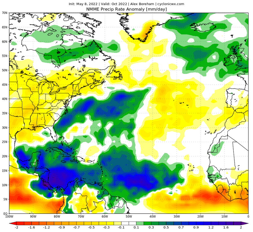
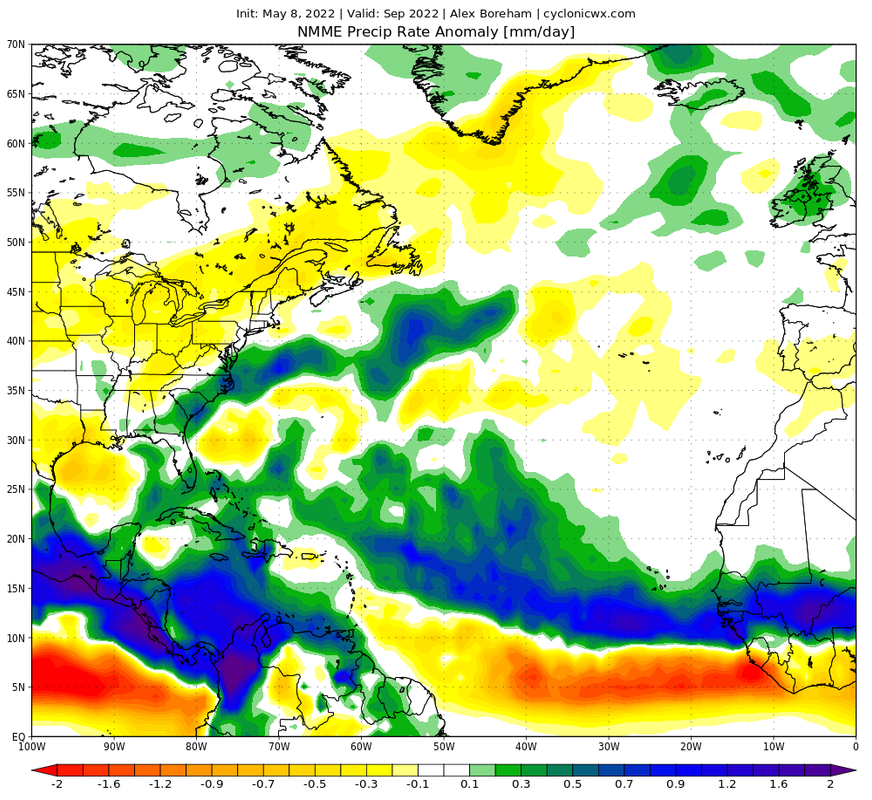
The NMME ensemble for this month has been released. There is not very much new information, but it is further confirmation of the projected pattern for ASO this year.

Image

Image

Of things to note in this model run are:

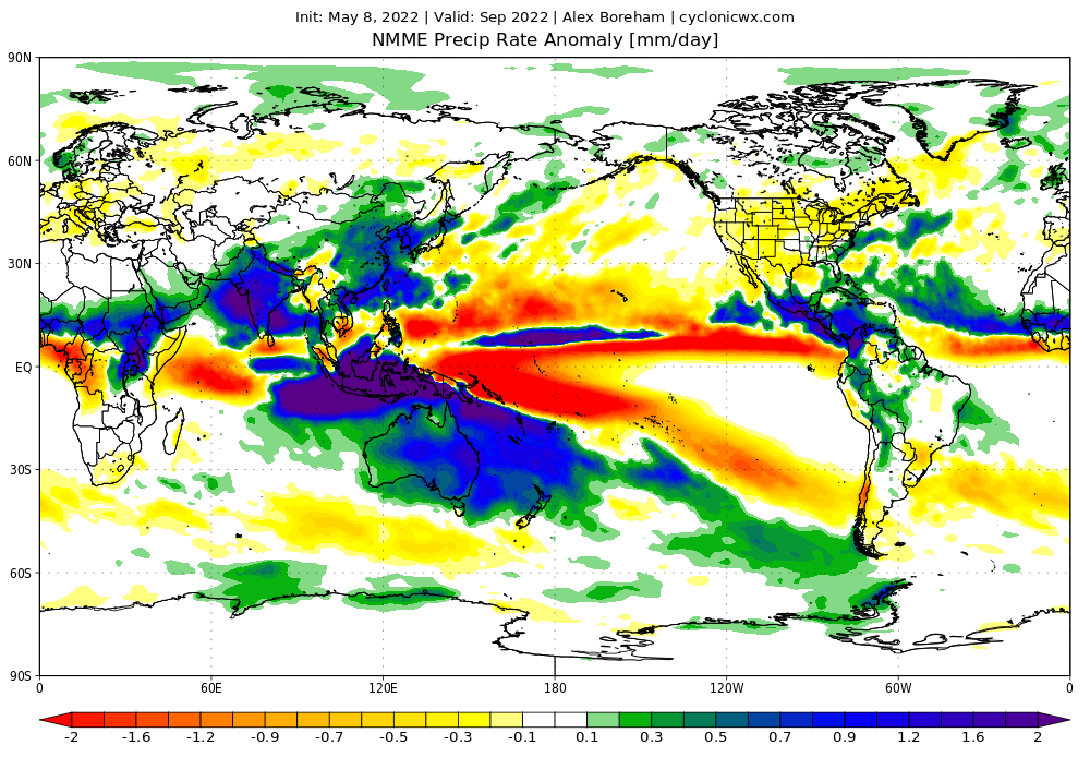
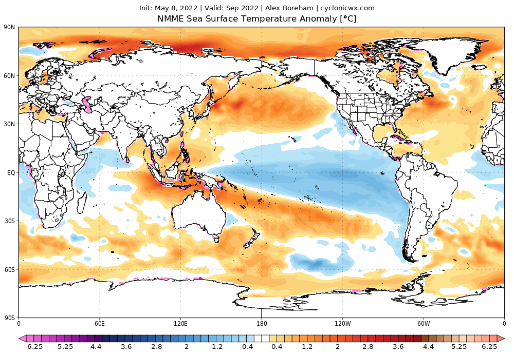
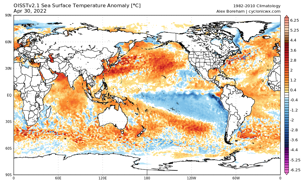
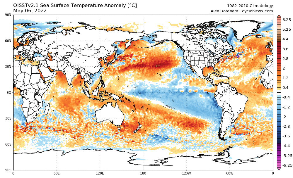
  • The -ENSO: Most strikingly on this model run is the -ENSO, which means wetter-than-average conditions for those in Australia and East Asia and drier-than-average conditions for those on the Pacific coasts of North and South America. However, for people who track the tropics, a -ENSO means a less active Pacific Hurricane Season and a more active Atlantic Hurricane Season, especially given the fact that the strongest cool anomalies in the Equatorial Pacific seem to be closer to South America instead of Indonesia, making this a classic -ENSO.
  • The -PDO: This recent negative phase of the Pacific Decadal Oscillation that has been persisting since early 2020 is a major contributor to the ongoing drought in the Western United States, and the NMME shows it continuing into September of this year. -PDOs are associated with drought in Western North America and sinking air in the East Pacific Ocean, leading to a less active Pacific Hurricane Season and a more active Atlantic Hurricane Season.
  • The -IOD: IOD and ENSO are usually correlated; +ENSO correlates with +IOD, and -ENSO correlates with -IOD. -IOD means drier-than-average conditions for East Africa and wetter-than-average conditions for Southeast Asia. Given the combination of -ENSO and -IOD, one can expect Indonesia to receive major rainfall this year, which is also projected by the NMME.
  • The Atlantic Niña: Just as striking as the -ENSO on this model is the Atlantic Niña. Strong Atlantic Niños have been able to produce El Niño-like effects across the Atlantic during La Niña years; for instance, the 2007 and 2021 zonal wind maps looks like those of +ENSO years, and their late seasons were dead. For the tropics, an Atlantic Niña means a northward ITCZ, which means a greater chance of storms developing in the Caribbean Sea and a more active Atlantic Hurricane Season overall. Furthermore, the ITCZ seems to be more northern than average on the precipitation anomaly map, which further supports the Atlantic Niña.
  • The +AMO: The Eastern United States has been most able to escape major drought because of the persistent +AMO. Throughout the past three decades, SSTAs in the Atlantic Ocean have been higher than global SSTAs, and that is expected to continue into September. In terms of the tropics, a +AMO means a more active Atlantic Hurricane Season.
  • The +AMM: There is a certain area where SSTAs are most correlated with Atlantic ACE: the AMM horseshoe, which extends from the Canary Islands to the MDR. The NMME shows a +AMM throughout ASO, which is further supported by an Atlantic Niña. A +AMM brings the ITCZ farther north, supporting more hurricane activity in the Atlantic.
  • The +WAM: The WAM is projected to be very strong. Strong WAMs have two major consequences: above-average rainfall over the Sahel and above-average Atlantic Hurricane Seasons. However, with such as strong WAM, Cape Verde activity might be hindered. The seasons with the heaviest MDR activity (such as 2017) often have weaker WAMs than seasons based in the Western Atlantic (such as 2020).

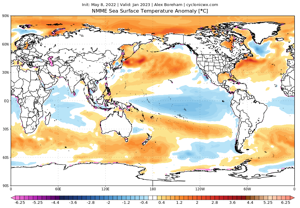
Finally, while the CFSv2 might be showing ENSO-neutral conditions for this winter, the NMME ensemble still shows definite -ENSO conditions for this winter:

Image
Last edited by AlphaToOmega on Sat May 07, 2022 1:01 pm, edited 1 time in total.
5 likes   

User avatar
cycloneye
Admin
Admin
Posts: 145324
Age: 68
Joined: Thu Oct 10, 2002 10:54 am
Location: San Juan, Puerto Rico

Re: 2022 indicators: SSTs / SAL / MSLP / shear / steering / instability / images

#685 Postby cycloneye » Sat May 07, 2022 12:55 pm

1 likes   
Visit the Caribbean-Central America Weather Thread where you can find at first post web cams,radars
and observations from Caribbean basin members Click Here

User avatar
cycloneye
Admin
Admin
Posts: 145324
Age: 68
Joined: Thu Oct 10, 2002 10:54 am
Location: San Juan, Puerto Rico

Re: 2022 indicators: SSTs / SAL / MSLP / shear / steering / instability / images

#686 Postby cycloneye » Sat May 07, 2022 1:15 pm

More takes from NMME and this concerns me where I am sitting.

 https://twitter.com/cyclonicwx/status/1523001095450025985


4 likes   
Visit the Caribbean-Central America Weather Thread where you can find at first post web cams,radars
and observations from Caribbean basin members Click Here

User avatar
SFLcane
S2K Supporter
S2K Supporter
Posts: 10163
Age: 47
Joined: Sat Jun 05, 2010 1:44 pm
Location: Lake Worth Florida

Re: 2022 indicators: SSTs / SAL / MSLP / shear / steering / instability / images

#687 Postby SFLcane » Sat May 07, 2022 1:21 pm

Image

Image
0 likes   

User avatar
Category5Kaiju
Category 5
Category 5
Posts: 4097
Joined: Thu Dec 24, 2020 12:45 pm
Location: Seattle

Re: 2022 indicators: SSTs / SAL / MSLP / shear / steering / instability / images

#688 Postby Category5Kaiju » Sat May 07, 2022 1:33 pm

1 likes   
Unless explicitly stated, all info in my posts is based on my own opinions and observations. Tropical storms and hurricanes can be extremely dangerous. Do not think you can beat Mother Nature. Refer to an accredited weather research agency or meteorologist if you need to make serious decisions regarding an approaching storm.

User avatar
SFLcane
S2K Supporter
S2K Supporter
Posts: 10163
Age: 47
Joined: Sat Jun 05, 2010 1:44 pm
Location: Lake Worth Florida

Re: 2022 indicators: SSTs / SAL / MSLP / shear / steering / instability / images: Latest NMME is up

#689 Postby SFLcane » Sat May 07, 2022 1:34 pm

This “ could “ be a problem.

Just like it showed last year :P

Image
1 likes   

User avatar
DorkyMcDorkface
Category 3
Category 3
Posts: 888
Age: 27
Joined: Mon Sep 30, 2019 1:32 pm
Location: Mid-Atlantic

Re: 2022 indicators: SSTs / SAL / MSLP / shear / steering / instability / images: Latest NMME is up

#690 Postby DorkyMcDorkface » Sat May 07, 2022 1:36 pm


You can pick out a northward-displaced TUTT on there if you look closely.
Last edited by DorkyMcDorkface on Sat May 07, 2022 1:40 pm, edited 1 time in total.
3 likes   

Please note the thougths expressed by this account are solely those of the user and are from a hobbyist perspective. For more comprehensive analysis, consult an actual professional meteorologist or meteorology agency.


Floyd 1999 | Isabel 2003 | Hanna 2008 | Irene 2011 | Sandy 2012 | Isaias 2020

User avatar
Stormybajan
Category 1
Category 1
Posts: 448
Joined: Thu May 20, 2021 3:21 pm
Location: Windward Islands

Re: 2022 indicators: SSTs / SAL / MSLP / shear / steering / instability / images

#691 Postby Stormybajan » Sat May 07, 2022 1:38 pm


Thats a seriously soaked signal there for October :double: . Lets hope this forecast changes overtime..so many signals for a busy MDR and caribbean this hurricane season
0 likes   
Sad West Indies and Manchester United fan ⚽️

User avatar
SFLcane
S2K Supporter
S2K Supporter
Posts: 10163
Age: 47
Joined: Sat Jun 05, 2010 1:44 pm
Location: Lake Worth Florida

Re: 2022 indicators: SSTs / SAL / MSLP / shear / steering / instability / images: Latest NMME is up

#692 Postby SFLcane » Sat May 07, 2022 1:42 pm

“ BUT” The orientation of that ridge on the NMME definitely looks interesting for the east coast if it verifies.
1 likes   

AutoPenalti
Category 5
Category 5
Posts: 4030
Age: 29
Joined: Mon Aug 17, 2015 4:16 pm
Location: Ft. Lauderdale, Florida

Re: 2022 indicators: SSTs / SAL / MSLP / shear / steering / instability / images: Latest NMME is up

#693 Postby AutoPenalti » Sat May 07, 2022 2:20 pm

Sounds like Adrian is hinting a some close call OTS tracks :wink:
0 likes   
The posts in this forum are NOT official forecasts and should not be used as such. They are just the opinion of the poster and may or may not be backed by sound meteorological data. They are NOT endorsed by any professional institution or STORM2K. For official information, please refer to products from the NHC and NWS.


Model Runs Cheat Sheet:
GFS (5:30 AM/PM, 11:30 AM/PM)
HWRF, GFDL, UKMET, NAVGEM (6:30-8:00 AM/PM, 12:30-2:00 AM/PM)
ECMWF (1:45 AM/PM)

TCVN
is a weighted averaged

User avatar
skyline385
Category 5
Category 5
Posts: 2728
Age: 35
Joined: Wed Aug 26, 2020 11:15 pm
Location: Houston TX

Re: 2022 indicators: SSTs / SAL / MSLP / shear / steering / instability / images: Latest NMME is up

#694 Postby skyline385 » Sat May 07, 2022 2:25 pm

Very true for this thread as well, one bullish model and everyone's here lol

 https://twitter.com/AndyHazelton/status/1523016777856217089


The opposite as well in a few months

 https://twitter.com/AndyHazelton/status/1523027380708810752


10 likes   

User avatar
Category5Kaiju
Category 5
Category 5
Posts: 4097
Joined: Thu Dec 24, 2020 12:45 pm
Location: Seattle

Re: 2022 indicators: SSTs / SAL / MSLP / shear / steering / instability / images: Latest NMME is up

#695 Postby Category5Kaiju » Sat May 07, 2022 3:34 pm

 https://twitter.com/Nichola76551479/status/1523037407943090176


But just imagine if the 2013 comparisons never even get a chance to materialize in the first place with the persistent -ENSO :D
1 likes   
Unless explicitly stated, all info in my posts is based on my own opinions and observations. Tropical storms and hurricanes can be extremely dangerous. Do not think you can beat Mother Nature. Refer to an accredited weather research agency or meteorologist if you need to make serious decisions regarding an approaching storm.

User avatar
Iceresistance
Category 5
Category 5
Posts: 9288
Age: 21
Joined: Sat Oct 10, 2020 9:45 am
Location: Tecumseh, OK/Norman, OK

Re: 2022 indicators: SSTs / SAL / MSLP / shear / steering / instability / images: Latest NMME is up

#696 Postby Iceresistance » Sat May 07, 2022 3:38 pm

WxTwitter can't decide on what 2022 is going to do in the Atlantic . . . :lol:
0 likes   
Bill 2015 & Beta 2020

Winter 2020-2021 :cold:

All observations are in Tecumseh, OK unless otherwise noted.

Winter posts are focused mainly for Oklahoma & Texas.

Take any of my forecasts with a grain of salt, refer to the NWS, SPC, and NHC for official information

Never say Never with weather! Because ANYTHING is possible!

User avatar
SFLcane
S2K Supporter
S2K Supporter
Posts: 10163
Age: 47
Joined: Sat Jun 05, 2010 1:44 pm
Location: Lake Worth Florida

Re: 2022 indicators: SSTs / SAL / MSLP / shear / steering / instability / images: Latest NMME is up

#697 Postby SFLcane » Sat May 07, 2022 4:11 pm

DorkyMcDorkface wrote:

You can pick out a northward-displaced TUTT on there if you look closely.


No.

 https://twitter.com/cyclonicwx/status/1523009181355237377


0 likes   

User avatar
DorkyMcDorkface
Category 3
Category 3
Posts: 888
Age: 27
Joined: Mon Sep 30, 2019 1:32 pm
Location: Mid-Atlantic

Re: 2022 indicators: SSTs / SAL / MSLP / shear / steering / instability / images: Latest NMME is up

#698 Postby DorkyMcDorkface » Sat May 07, 2022 4:21 pm

SFLcane wrote:
DorkyMcDorkface wrote:

You can pick out a northward-displaced TUTT on there if you look closely.


No.

https://twitter.com/cyclonicwx/status/1523009181355237377?s=21&t=dz4bJQX9HIJlAtdKUAu9lA

Huh? That tweet is highlighting the same thing I took note of lol
2 likes   

Please note the thougths expressed by this account are solely those of the user and are from a hobbyist perspective. For more comprehensive analysis, consult an actual professional meteorologist or meteorology agency.


Floyd 1999 | Isabel 2003 | Hanna 2008 | Irene 2011 | Sandy 2012 | Isaias 2020

User avatar
SFLcane
S2K Supporter
S2K Supporter
Posts: 10163
Age: 47
Joined: Sat Jun 05, 2010 1:44 pm
Location: Lake Worth Florida

Re: 2022 indicators: SSTs / SAL / MSLP / shear / steering / instability / images

#699 Postby SFLcane » Sat May 07, 2022 5:11 pm

0 likes   

User avatar
SFLcane
S2K Supporter
S2K Supporter
Posts: 10163
Age: 47
Joined: Sat Jun 05, 2010 1:44 pm
Location: Lake Worth Florida

Re: 2022 indicators: SSTs / SAL / MSLP / shear / steering / instability / images

#700 Postby SFLcane » Sat May 07, 2022 5:13 pm

That's basically a summary of the last 10 years (minus the inactive years). There's actually a general minimum on the track towards S FL.
0 likes   


Return to “Talkin' Tropics”

Who is online

Users browsing this forum: Google Adsense [Bot], JtSmarts, Stratton23 and 46 guests