https://twitter.com/RaleighWx/status/1523726735350456320
2022 Global Model Runs Discussion (Out thru day 16)
Moderator: S2k Moderators
Forum rules

The posts in this forum are NOT official forecasts and should not be used as such. They are just the opinion of the poster and may or may not be backed by sound meteorological data. They are NOT endorsed by any professional institution or STORM2K. For official information, please refer to products from the National Hurricane Center and National Weather Service.

Re: 2022 Global Model Runs Discussion (Out thru day 16)
0 likes
-
skyline385

- Category 5

- Posts: 2728
- Age: 35
- Joined: Wed Aug 26, 2020 11:15 pm
- Location: Houston TX
Re: 2022 Global Model Runs Discussion (Out thru day 16)
SFLcane wrote::roll:
Happy hour GFS at it again?
0 likes
-
Category5Kaiju

- Category 5
- Posts: 4346
- Joined: Thu Dec 24, 2020 12:45 pm
- Location: Seattle during the summer, Phoenix during the winter
Re: 2022 Global Model Runs Discussion (Out thru day 16)
skyline385 wrote:SFLcane wrote::roll:
https://i.postimg.cc/PxkWGbgK/A0-C8-AEED-60-E5-49-F4-9-B23-2-E1-A29-B7-FF1-E.gif
Happy hour GFS at it again?
If we do get a Category 3 hurricane in the W Atl in May, I'm going to move to the moon. Because that means this season is going to be REALLY bad
1 likes
Unless explicitly stated, all information in my posts is based on my own opinions and observations. Tropical storms and hurricanes can be extremely dangerous. Refer to an accredited weather research agency or meteorologist if you need to make serious decisions regarding an approaching storm.
-
AJC3

- Admin

- Posts: 4156
- Age: 62
- Joined: Tue Aug 31, 2004 7:04 pm
- Location: Ballston Spa, New York
- Contact:
Re: 2022 Global Model Runs Discussion (Out thru day 16)
Gang,
We've made a tweak to the seasonal indicators thread so that from now onward, hyper-long range (past day 16) global model output should be posted in that thread.
https://www.storm2k.org/phpbb2/viewtopi ... 1&t=122492
Thanks.
We've made a tweak to the seasonal indicators thread so that from now onward, hyper-long range (past day 16) global model output should be posted in that thread.
https://www.storm2k.org/phpbb2/viewtopi ... 1&t=122492
Thanks.
4 likes
-
skyline385
- Category 5
- Posts: 2728
- Age: 35
- Joined: Wed Aug 26, 2020 11:15 pm
- Location: Houston TX
Re: 2022 Global Model Runs Discussion (Out thru day 16)
Category5Kaiju wrote:skyline385 wrote:SFLcane wrote::roll:
https://i.postimg.cc/PxkWGbgK/A0-C8-AEED-60-E5-49-F4-9-B23-2-E1-A29-B7-FF1-E.gif
Happy hour GFS at it again?
If we do get a Category 3 hurricane in the W Atl in May, I'm going to move to the moon. Because that means this season is going to be REALLY bad
Imagine SFL's shield being broken by a May Cat 3/4
2 likes
-
AutoPenalti
- Category 5
- Posts: 4091
- Age: 29
- Joined: Mon Aug 17, 2015 4:16 pm
- Location: Ft. Lauderdale, Florida
Re: 2022 Global Model Runs Discussion (Out thru day 16)
Any sort of TC trying to form in the W Carr will have a hard time trying to intensify.
3 likes
The posts in this forum are NOT official forecasts and should not be used as such. They are just the opinion of the poster and may or may not be backed by sound meteorological data. They are NOT endorsed by any professional institution or STORM2K. For official information, please refer to products from the NHC and NWS.
Model Runs Cheat Sheet:
GFS (5:30 AM/PM, 11:30 AM/PM)
HWRF, GFDL, UKMET, NAVGEM (6:30-8:00 AM/PM, 12:30-2:00 AM/PM)
ECMWF (1:45 AM/PM)
TCVN is a weighted averaged
-
SFLcane

- S2K Supporter

- Posts: 10281
- Age: 48
- Joined: Sat Jun 05, 2010 1:44 pm
- Location: Lake Worth Florida
Re: 2022 Global Model Runs Discussion (Out thru day 16)
AutoPenalti wrote:
Any sort of TC trying to form in the W Carr will have a hard time trying to intensify.
Its ok lol its May. SFL needs the rain.
3 likes
-
Category5Kaiju
- Category 5
- Posts: 4346
- Joined: Thu Dec 24, 2020 12:45 pm
- Location: Seattle during the summer, Phoenix during the winter
Re: 2022 Global Model Runs Discussion (Out thru day 16)
AutoPenalti wrote:
Any sort of TC trying to form in the W Carr will have a hard time trying to intensify.
Considering shear and dry air, it's likely. But there is a caveat:


Assuming these hold up, thermodynamics should not be an issue at all.
3 likes
Unless explicitly stated, all information in my posts is based on my own opinions and observations. Tropical storms and hurricanes can be extremely dangerous. Refer to an accredited weather research agency or meteorologist if you need to make serious decisions regarding an approaching storm.
-
skyline385
- Category 5
- Posts: 2728
- Age: 35
- Joined: Wed Aug 26, 2020 11:15 pm
- Location: Houston TX
Re: 2022 Global Model Runs Discussion (Out thru day 16)
Happy hour GFS not disappointing again

1 likes
-
skyline385
- Category 5
- Posts: 2728
- Age: 35
- Joined: Wed Aug 26, 2020 11:15 pm
- Location: Houston TX


Re: 2022 Global Model Runs Discussion (Out thru day 16)
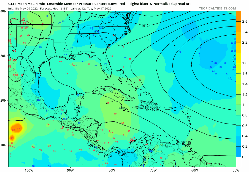
skyline385 wrote:https://i.imgur.com/oJ2km5P.png
Looks like it comes from a CAG that forms around next Saturday
0 likes
Irene '11 Sandy '12 Hermine '16 5/15/2018 Derecho Fay '20 Isaias '20 Elsa '21 Henri '21 Ida '21
I am only a meteorology enthusiast who knows a decent amount about tropical cyclones. Look to the professional mets, the NHC, or your local weather office for the best information.
I am only a meteorology enthusiast who knows a decent amount about tropical cyclones. Look to the professional mets, the NHC, or your local weather office for the best information.
-
SFLcane
- S2K Supporter
- Posts: 10281
- Age: 48
- Joined: Sat Jun 05, 2010 1:44 pm
- Location: Lake Worth Florida
Re: 2022 Global Model Runs Discussion (Out thru day 16)
If the fantasy GFS had its way every year would be 2005. 
3 likes
-
skyline385
- Category 5
- Posts: 2728
- Age: 35
- Joined: Wed Aug 26, 2020 11:15 pm
- Location: Houston TX
Re: 2022 Global Model Runs Discussion (Out thru day 16)
SFLcane wrote:If the fantasy GFS had its way every year would be 2005.
It is very likely a phantom but something to note though is that every run in the past few days have had atleast some ensemble members develop consistently in the Caribbean so the possibility is still there.
0 likes
-
DorkyMcDorkface

- Category 5
- Posts: 1043
- Age: 28
- Joined: Mon Sep 30, 2019 1:32 pm
- Location: Mid-Atlantic
Re: 2022 Global Model Runs Discussion (Out thru day 16)
skyline385 wrote:https://i.imgur.com/oJ2km5P.png
Thankfully it appears to be spurious. Watch that stream of vorticity off Venezuela - GFS has a tendency to spin up systems from that thing for some reason. It's good entertainment though

3 likes
Please note the thoughts expressed by this account are solely those of the user and are from a hobbyist perspective. For more comprehensive analysis, consult an actual professional meteorologist or meteorological agency.
Floyd 1999 | Isabel 2003 | Hanna 2008 | Irene 2011 | Sandy 2012 | Isaias 2020
-
tolakram
- Admin
- Posts: 20186
- Age: 62
- Joined: Sun Aug 27, 2006 8:23 pm
- Location: Florence, KY (name is Mark)
Re: 2022 Global Model Runs Discussion (Out thru day 16)
That looks like EPAC to me. Almost every year when the GFS shows development in that area it ends up being in the EPAC. Not every time, but almost every time.
0 likes
M a r k
- - - - -
Join us in chat: Storm2K Chatroom Invite. Android and IOS apps also available.
The posts in this forum are NOT official forecasts and should not be used as such. Posts are NOT endorsed by any professional institution or STORM2K.org. For official information and forecasts, please refer to NHC and NWS products.
-
toad strangler

- S2K Supporter
- Posts: 4546
- Joined: Sun Jul 28, 2013 3:09 pm
- Location: Earth
- Contact:
Re: 2022 Global Model Runs Discussion (Out thru day 16)
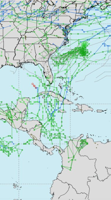
DorkyMcDorkface wrote:skyline385 wrote:https://i.imgur.com/oJ2km5P.png
Thankfully it appears to be spurious. Watch that stream of vorticity off Venezuela - GFS has a tendency to spin up systems from that thing for some reason. It's good entertainment though
https://i.ibb.co/0cBMDzq/gfs-z850-vort-watl-fh156-270.gif
It's an epic phantom pezz dispenser late in the season too. I wonder what makes the GFS spit out vorts like that and if anything can be done to fix it.
0 likes
My Weather Station
https://www.wunderground.com/dashboard/pws/KFLPORTS603
https://www.wunderground.com/dashboard/pws/KFLPORTS603
Re: 2022 Global Model Runs Discussion (Out thru day 16)
DorkyMcDorkface wrote:skyline385 wrote:https://i.imgur.com/oJ2km5P.png
Thankfully it appears to be spurious. Watch that stream of vorticity off Venezuela - GFS has a tendency to spin up systems from that thing for some reason. It's good entertainment though
https://i.ibb.co/0cBMDzq/gfs-z850-vort-watl-fh156-270.gif
Might be from a low-latitude wave. I think the GFS did this a lot last Oct/Nov, when the ITCZ was so far south that every wave ran over northern SA when entering the Caribbean. Regardless of whether the source of that vorticity is legitimate or spurious, the incoming MJO is probably getting the GFS all excited.
0 likes
Irene '11 Sandy '12 Hermine '16 5/15/2018 Derecho Fay '20 Isaias '20 Elsa '21 Henri '21 Ida '21
I am only a meteorology enthusiast who knows a decent amount about tropical cyclones. Look to the professional mets, the NHC, or your local weather office for the best information.
I am only a meteorology enthusiast who knows a decent amount about tropical cyclones. Look to the professional mets, the NHC, or your local weather office for the best information.
Who is online
Users browsing this forum: No registered users and 193 guests