That line in KS did make it just far enough south to give me around .02in of rain but at least it's something. I just got upgraded to a marginal risk for tonight so maybe we can get something there as well, as long as tomorrow stays dry.
12z GFS is quite the run there and next week is looking pretty great for rain/storms but it's a week out so there's obviously enough time for that to change like usual...
I do think we need to keep an eye on this Friday however, just a marginal risk for now, but I think we could see some upgrades on later outlooks. Parameters are looking decent for a wind/hail event, probably not much of a tornado threat. Will be interesting to see what the CAMs show over the next couple days.
Texas Spring 2022
Moderator: S2k Moderators
Forum rules

The posts in this forum are NOT official forecast and should not be used as such. They are just the opinion of the poster and may or may not be backed by sound meteorological data. They are NOT endorsed by any professional institution or STORM2K.
-
ElectricStorm

- Category 5

- Posts: 5140
- Age: 25
- Joined: Tue Aug 13, 2019 11:23 pm
- Location: Norman, OK
Re: Texas Spring 2022
0 likes
B.S Meteorology, University of Oklahoma '25
Please refer to the NHC, NWS, or SPC for official information.
Please refer to the NHC, NWS, or SPC for official information.


Re: Texas Spring 2022
12z gfs is beautiful I hope it pans out! Would alleviate a lot of the drought!!
2 likes
The above post and any post by Ntxw is NOT an official forecast and should not be used as such. It is just the opinion of the poster and may or may not be backed by sound meteorological data. It is NOT endorsed by any professional institution including Storm2k. For official information, please refer to NWS products.
Help support Storm2K!
-
captainbarbossa19

- Professional-Met

- Posts: 1094
- Age: 27
- Joined: Wed Aug 21, 2019 11:09 pm
- Location: Beaumont, TX
Re: Texas Spring 2022
Ntxw wrote:12z gfs is beautiful I hope it pans out! Would alleviate a lot of the drought!!
I do not recall any models showing so much rain this year within 5-10 days, so I would say the odds of a big rain event are rather high now. It's more than one model showing lots of rain too, so that's even more optimistic. Also, so much rain in this time period should help decrease afternoon temperatures quite a bit.
3 likes

Re: Texas Spring 2022
Ntxw wrote:12z gfs is beautiful I hope it pans out! Would alleviate a lot of the drought!!
The question I have is where’s this coming from with so many negative factors working against it?
0 likes
Re: Texas Spring 2022
Cpv17 wrote:Ntxw wrote:12z gfs is beautiful I hope it pans out! Would alleviate a lot of the drought!!
The question I have is where’s this coming from with so many negative factors working against it?
CCKW passage over the Pacific and western hemisphere this past week. So it's a little taste of pseudo ninoesque forcing. Pacific convection is mostly a good thing. It's mostly over though so the pattern lags a bit. I think it reverts back because nothing supports it after as things go back to the background state. 3-4 or 3-6 days of relief.
0 likes
The above post and any post by Ntxw is NOT an official forecast and should not be used as such. It is just the opinion of the poster and may or may not be backed by sound meteorological data. It is NOT endorsed by any professional institution including Storm2k. For official information, please refer to NWS products.
Help support Storm2K!
Help support Storm2K!
-
South Texas Storms

- Professional-Met
- Posts: 4256
- Joined: Thu Jun 24, 2010 12:28 am
- Location: Houston, TX
Re: Texas Spring 2022
Ntxw wrote:Cpv17 wrote:Ntxw wrote:12z gfs is beautiful I hope it pans out! Would alleviate a lot of the drought!!
The question I have is where’s this coming from with so many negative factors working against it?
CCKW passage over the Pacific and western hemisphere this past week. So it's a little taste of pseudo ninoesque forcing. Pacific convection is mostly a good thing. It's mostly over though so the pattern lags a bit. I think it reverts back because nothing supports it after as things go back to the background state. 3-4 or 3-6 days of relief.
I'm not so sure about that. Latest ensembles continue to hint at a slight weakness developing over the region during the last few days of May and into early June. Will likely bring another round of unsettled weather if it verifies.
2 likes
-
weatherdude1108
- Category 5
- Posts: 4228
- Joined: Tue Dec 13, 2011 1:04 pm
- Location: Northwest Austin/Cedar Park, TX
Re: Texas Spring 2022
South Texas Storms wrote:weatherdude1108 wrote:Back to Texas again.lol
Probably not within range of the NHC forecasts yet to get their attention. Sea temps warm, but lots of shear. Would be the earliest Texas landfalling hurricane since records began. I think I heard June 1967 was the earliest Texas landfall(?). Not sure.
https://www.tropicaltidbits.com/analysis/models/gfs/2022051212/gfs_mslp_pcpn_frzn_scus_64.png
That run is from 5 days ago. The GFS continues to be an outlier in developing a TC in the northwest Caribbean later this month. It's solution is quite unlikely.
Oh geez. Sorry about that!
1 likes
The preceding post is NOT an official forecast, and should not be used as such. It is only the opinion of the poster and may or may not be backed by sound meteorological data. It is NOT endorsed by any professional institution including storm2k.org. For Official Information please refer to the NHC and NWS products.
Re: Texas Spring 2022
South Texas Storms wrote:Ntxw wrote:Cpv17 wrote:
The question I have is where’s this coming from with so many negative factors working against it?
CCKW passage over the Pacific and western hemisphere this past week. So it's a little taste of pseudo ninoesque forcing. Pacific convection is mostly a good thing. It's mostly over though so the pattern lags a bit. I think it reverts back because nothing supports it after as things go back to the background state. 3-4 or 3-6 days of relief.
I'm not so sure about that. Latest ensembles continue to hint at a slight weakness developing over the region during the last few days of May and into early June. Will likely bring another round of unsettled weather if it verifies.
I'm skeptical given sinking motion returning to the central Pacific and OLR returning to the MC. We'll have to see what the CAG does. It could get trapped under a ridge as it moves north. I'll take that but I don't trust it.
1 likes
The above post and any post by Ntxw is NOT an official forecast and should not be used as such. It is just the opinion of the poster and may or may not be backed by sound meteorological data. It is NOT endorsed by any professional institution including Storm2k. For official information, please refer to NWS products.
Help support Storm2K!
Help support Storm2K!
Re: Texas Spring 2022

Last edited by Cpv17 on Wed May 18, 2022 3:16 pm, edited 2 times in total.
3 likes
-
rwfromkansas
- Category 5
- Posts: 3021
- Joined: Sat Aug 27, 2005 12:47 am
- Location: North Fort Worth
Re: Texas Spring 2022
Good news: no 100s this week I think unless we hit it at DFW and I missed it, but tomorrow through Friday look to be below.
0 likes
Re: Texas Spring 2022
rwfromkansas wrote:Good news: no 100s this week I think unless we hit it at DFW and I missed it, but tomorrow through Friday look to be below.
No 100s, one more chance to tomorrow but for the most part we've managed to keep under forecast a little bit each day with cloud cover and/or higher dews.
0 likes
The above post and any post by Ntxw is NOT an official forecast and should not be used as such. It is just the opinion of the poster and may or may not be backed by sound meteorological data. It is NOT endorsed by any professional institution including Storm2k. For official information, please refer to NWS products.
Help support Storm2K!
Help support Storm2K!
-
Iceresistance

- Category 5
- Posts: 9579
- Age: 22
- Joined: Sat Oct 10, 2020 9:45 am
- Location: Tecumseh, OK/Norman, OK
Re: Texas Spring 2022
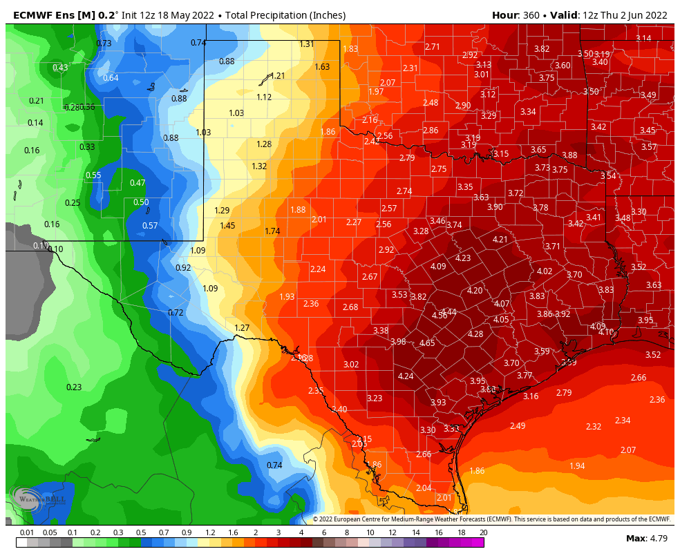
WPC is looking really nice for Texas, I see 4-5 inches of rain in the next 7 days from the WPC 
4 likes
Bill 2015 & Beta 2020
Winter 2020-2021
All observations are in Tecumseh, OK unless otherwise noted.
Winter posts are focused mainly for Oklahoma & Texas.
Take any of my forecasts with a grain of salt, refer to the NWS, SPC, and NHC for official information
Never say Never with weather! Because ANYTHING is possible!
Winter 2020-2021
All observations are in Tecumseh, OK unless otherwise noted.
Winter posts are focused mainly for Oklahoma & Texas.
Take any of my forecasts with a grain of salt, refer to the NWS, SPC, and NHC for official information
Never say Never with weather! Because ANYTHING is possible!
Re: Texas Spring 2022

6 likes
The above post and any post by Ntxw is NOT an official forecast and should not be used as such. It is just the opinion of the poster and may or may not be backed by sound meteorological data. It is NOT endorsed by any professional institution including Storm2k. For official information, please refer to NWS products.
Help support Storm2K!
Help support Storm2K!
Re: Texas Spring 2022
FYI a little unrelated but for those who haven't read, Hunga-Tonga eruption back in January in the South Pacific was the largest volcanic eruption since Krakatoa in 1883 now that more data has come in. It's plume reached 36 miles, highest that we've recorded in modern history. For comparison Pinatubo in 1991 reached 22 miles up. Early on this was very much a muted incident as far as how much/how high it's plume went with lack of data and everyone playing the safe card. Definitely a wild card with a lot of questions what role it will play as the months go on.
3 likes
The above post and any post by Ntxw is NOT an official forecast and should not be used as such. It is just the opinion of the poster and may or may not be backed by sound meteorological data. It is NOT endorsed by any professional institution including Storm2k. For official information, please refer to NWS products.
Help support Storm2K!
Help support Storm2K!
-
Iceresistance
- Category 5
- Posts: 9579
- Age: 22
- Joined: Sat Oct 10, 2020 9:45 am
- Location: Tecumseh, OK/Norman, OK
Re: Texas Spring 2022
I’ll let Texas have the fun, I had enough of the rainfall now that I’m out of the drought.
The colder temperatures would be very nice because my AC unit is bad, out of Freon and it has a hole in it (Sucking in the air by itself). It’s going to be a while (or a couple of weeks) before it’s replaced because the unit is considered a total loss.
0 likes
Bill 2015 & Beta 2020
Winter 2020-2021
All observations are in Tecumseh, OK unless otherwise noted.
Winter posts are focused mainly for Oklahoma & Texas.
Take any of my forecasts with a grain of salt, refer to the NWS, SPC, and NHC for official information
Never say Never with weather! Because ANYTHING is possible!
Winter 2020-2021
All observations are in Tecumseh, OK unless otherwise noted.
Winter posts are focused mainly for Oklahoma & Texas.
Take any of my forecasts with a grain of salt, refer to the NWS, SPC, and NHC for official information
Never say Never with weather! Because ANYTHING is possible!
-
bubba hotep

- S2K Supporter

- Posts: 6013
- Joined: Wed Dec 28, 2016 1:00 am
- Location: Collin County Texas
Re: Texas Spring 2022
Ntxw wrote:South Texas Storms wrote:Ntxw wrote:
CCKW passage over the Pacific and western hemisphere this past week. So it's a little taste of pseudo ninoesque forcing. Pacific convection is mostly a good thing. It's mostly over though so the pattern lags a bit. I think it reverts back because nothing supports it after as things go back to the background state. 3-4 or 3-6 days of relief.
I'm not so sure about that. Latest ensembles continue to hint at a slight weakness developing over the region during the last few days of May and into early June. Will likely bring another round of unsettled weather if it verifies.
I'm skeptical given sinking motion returning to the central Pacific and OLR returning to the MC. We'll have to see what the CAG does. It could get trapped under a ridge as it moves north. I'll take that but I don't trust it.
It also looks like there will be another MJO or CCKW pulse across the Pacific as we move into June. That would be another opportunity to shake things up and probably our first legit window for tropical threats. Also, the QBO is rather low and that can favor Western troughing and potentially keep a big heat ridge from setting up over the Southern Plains. It looks like this might occur via QBO modulation of tropical convection. The current QBO/ENSO phasing pairs up more closely to 2013 and is the opposite of 2011. The last big -QBO summer was 2015
 (but ENSO was more favorable for Texas rain)
2 likes
Winter time post are almost exclusively focused on the DFW area.
-
bubba hotep
- S2K Supporter
- Posts: 6013
- Joined: Wed Dec 28, 2016 1:00 am
- Location: Collin County Texas
Re: Texas Spring 2022
It looks like areas of Eastern and NE DFW could actually end up with above avg rainfall for Spring, esp. if this pans out. Some areas have already had 10"+ of rain so far this Spring.
3 likes
Winter time post are almost exclusively focused on the DFW area.
Re: Texas Spring 2022
bubba hotep wrote:It looks like areas of Eastern and NE DFW could actually end up with above avg rainfall for Spring, esp. if this pans out. Some areas have already had 10"+ of rain so far this Spring.
https://pbs.twimg.com/media/FTEPQnwWUAY2Wfl?format=png&name=medium
That map is beautiful!!

2 likes
-
Haris

- Category 5
- Posts: 1814
- Joined: Mon Nov 27, 2017 8:19 pm
- Location: ( Bee Cave) West Austin, Texas
Re: Texas Spring 2022
bubba hotep wrote:It looks like areas of Eastern and NE DFW could actually end up with above avg rainfall for Spring, esp. if this pans out. Some areas have already had 10"+ of rain so far this Spring.
https://pbs.twimg.com/media/FTEPQnwWUAY2Wfl?format=png&name=medium
Austin got 3.8" in May 2011. Right now we're at a 1/2" so I reallllyyy hope we can at least beat that number
2 likes
Weather geek and a storm spotter in West Austin. Not a degreed meteorologist. Big snow fan. Love rain and cold! Despise heat!

Re: Texas Spring 2022
Fire that started yesterday southwest of View (near Abilene) has gotten worse. It jumped containment and Hwy US 277 and now Buffalo Gap has been ordered to evacuation. NWS San Angelo has put up a Fire Warning.
https://twitter.com/TravisABC13/status/1527077932778377217
https://twitter.com/weatherdak/status/1527095712692858880
https://twitter.com/TravisABC13/status/1527077932778377217
https://twitter.com/weatherdak/status/1527095712692858880
0 likes
Return to “USA & Caribbean Weather”
Who is online
Users browsing this forum: AnnularCane, Haddox12, HockeyTx82, Tireman4 and 147 guests