Texas Spring 2022
Moderator: S2k Moderators
Forum rules

The posts in this forum are NOT official forecast and should not be used as such. They are just the opinion of the poster and may or may not be backed by sound meteorological data. They are NOT endorsed by any professional institution or STORM2K.
-
Iceresistance

- Category 5

- Posts: 9579
- Age: 22
- Joined: Sat Oct 10, 2020 9:45 am
- Location: Tecumseh, OK/Norman, OK
Re: Texas Spring 2022
Raining really nicely outside, don't know how much though. But I'm loving it! 53°F
3 likes
Bill 2015 & Beta 2020
Winter 2020-2021
All observations are in Tecumseh, OK unless otherwise noted.
Winter posts are focused mainly for Oklahoma & Texas.
Take any of my forecasts with a grain of salt, refer to the NWS, SPC, and NHC for official information
Never say Never with weather! Because ANYTHING is possible!
Winter 2020-2021
All observations are in Tecumseh, OK unless otherwise noted.
Winter posts are focused mainly for Oklahoma & Texas.
Take any of my forecasts with a grain of salt, refer to the NWS, SPC, and NHC for official information
Never say Never with weather! Because ANYTHING is possible!

Re: Texas Spring 2022
I ended up with 0.65" at my house Saturday night. Not as much as I was hoping for, but that is still helpful. The cooler weather yesterday and today has sure been refreshing.
I have a hard time seeing widespread 4-5" for NE TX like was depicted as of yesterday for the next couple of days. Models already trending downward. I think widespread 1"-3" is much more plausible with isolated higher amounts depending on convective processes and any potential training effects.
I have a hard time seeing widespread 4-5" for NE TX like was depicted as of yesterday for the next couple of days. Models already trending downward. I think widespread 1"-3" is much more plausible with isolated higher amounts depending on convective processes and any potential training effects.
0 likes
-
rwfromkansas
- Category 5
- Posts: 3024
- Joined: Sat Aug 27, 2005 12:47 am
- Location: North Fort Worth
Re: Texas Spring 2022
Wow, NAM says now barely anything for east TX. Shows how much things can change in a few days. Who knows what's going to happen. I think rain is likely. The question is...how much?
I am thinking 1-3 instead of the 4-6 predicted.
I am thinking 1-3 instead of the 4-6 predicted.
1 likes
Re: Texas Spring 2022
rwfromkansas wrote:Wow, NAM says now barely anything for east TX. Shows how much things can change in a few days. Who knows what's going to happen. I think rain is likely. The question is...how much?
I am thinking 1-3 instead of the 4-6 predicted.
Shreveport just issued a FFW for the Arklatex into ETX region, mentioning 3-5" possible with isolated higher amounts. I think they should have waited until tonight or tomorrow morning to evaluate further, but what do I know...

I hope they are right, we can use all the rain we can get before the death ridge sets in for summer.
0 likes
-
Brent
- S2K Supporter

- Posts: 38729
- Age: 37
- Joined: Sun May 16, 2004 10:30 pm
- Location: Tulsa Oklahoma
- Contact:
Re: Texas Spring 2022
56 degrees and been raining for hours. Today was supposed to be the drier of the 2 days
June is next week, right?
June is next week, right?
1 likes
#neversummer
-
captainbarbossa19

- Professional-Met

- Posts: 1094
- Age: 27
- Joined: Wed Aug 21, 2019 11:09 pm
- Location: Beaumont, TX
Re: Texas Spring 2022
Brent wrote:56 degrees and been raining for hours. Today was supposed to be the drier of the 2 days
June is next week, right?
I would love it if summer overall ended up being cooler than normal after this ridiculous heat wave this month. In my memory, the hottest summers tended to feature very hot Memorial Days. This year, the weather pretty much looks average.
1 likes
-
Brent
- S2K Supporter
- Posts: 38729
- Age: 37
- Joined: Sun May 16, 2004 10:30 pm
- Location: Tulsa Oklahoma
- Contact:
Re: Texas Spring 2022
captainbarbossa19 wrote:Brent wrote:56 degrees and been raining for hours. Today was supposed to be the drier of the 2 days
June is next week, right?
I would love it if summer overall ended up being cooler than normal after this ridiculous heat wave this month. In my memory, the hottest summers tended to feature very hot Memorial Days. This year, the weather pretty much looks average.
I don't even have a 90 on the entire 15 day forecast on the TWC app it gets close but I mean we were hotter than that already. Definitely makes you wonder
1 likes
#neversummer


Re: Texas Spring 2022
Well the good news is ensembles aren't showing any major heat waves. Low 90s is hot in May but for June in Texas is seasonably warm.
5 likes
The above post and any post by Ntxw is NOT an official forecast and should not be used as such. It is just the opinion of the poster and may or may not be backed by sound meteorological data. It is NOT endorsed by any professional institution including Storm2k. For official information, please refer to NWS products.
Help support Storm2K!
-
bubba hotep

- S2K Supporter
- Posts: 6013
- Joined: Wed Dec 28, 2016 1:00 am
- Location: Collin County Texas
Re: Texas Spring 2022
Ntxw wrote:Well the good news is ensembles aren't showing any major heat waves. Low 90s is hot in May but for June in Texas is seasonably warm.
Yea, the avg daily high goes up pretty quickly during May. The worst part about this last heatwave wasn't so much the heat (it really wasn't that bad) as it was that it stole the last few weeks of nice weather from us!
2 likes
Winter time post are almost exclusively focused on the DFW area.
Re: Texas Spring 2022
Shield of storms/rain in the southwestern zones trying to move into NTX. Fingers crossed they hold together.
2 likes
The above post and any post by Ntxw is NOT an official forecast and should not be used as such. It is just the opinion of the poster and may or may not be backed by sound meteorological data. It is NOT endorsed by any professional institution including Storm2k. For official information, please refer to NWS products.
Help support Storm2K!
Help support Storm2K!
-
Iceresistance
- Category 5
- Posts: 9579
- Age: 22
- Joined: Sat Oct 10, 2020 9:45 am
- Location: Tecumseh, OK/Norman, OK
Re: Texas Spring 2022
Ntxw wrote:Well the good news is ensembles aren't showing any major heat waves. Low 90s is hot in May but for June in Texas is seasonably warm.
Even the CPC has the risks of Excessive heat ending in June in Texas, but I don’t know how long though.
Also got 1 inch of rain so far. Temperature is only 56°F, don’t recall the last time there was a high in the 50s in Late May.
1 likes
Bill 2015 & Beta 2020
Winter 2020-2021
All observations are in Tecumseh, OK unless otherwise noted.
Winter posts are focused mainly for Oklahoma & Texas.
Take any of my forecasts with a grain of salt, refer to the NWS, SPC, and NHC for official information
Never say Never with weather! Because ANYTHING is possible!
Winter 2020-2021
All observations are in Tecumseh, OK unless otherwise noted.
Winter posts are focused mainly for Oklahoma & Texas.
Take any of my forecasts with a grain of salt, refer to the NWS, SPC, and NHC for official information
Never say Never with weather! Because ANYTHING is possible!

-
bubba hotep
- S2K Supporter
- Posts: 6013
- Joined: Wed Dec 28, 2016 1:00 am
- Location: Collin County Texas
Re: Texas Spring 2022
MCVs that survive the day can really crank out some heavy rainfall events during the overnight hours. The best sat and radar presentation in the state right now is associated with the southern cluster of storms that this is spinning towards DFW.
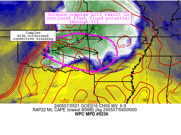
Mesoscale Precipitation Discussion 0236
NWS Weather Prediction Center College Park MD
649 PM EDT Mon May 23 2022
Areas affected...Central TX
Concerning...Heavy rainfall...Flash flooding possible
Valid 232248Z - 240348Z
SUMMARY...Locally expanding and backbuilding areas of heavy
showers and thunderstorms will pose at least a localized threat of
flash flooding heading through the evening hours.
DISCUSSION...The latest radar imagery suggests a weak MCV crossing
areas of the TX Hill Country late this afternoon, and this energy
more recently has been yielding some expansion of shower and
thunderstorm activity. Over the last 30 to 45 minutes, some of the
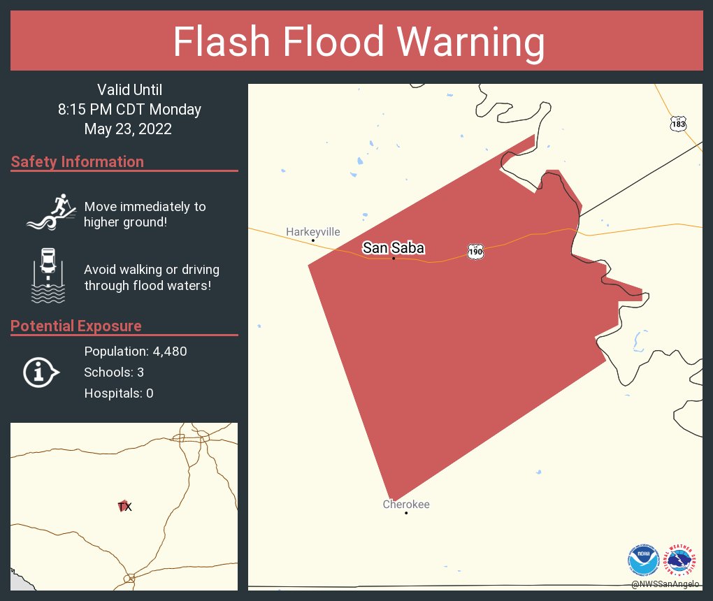
strongest activity has been over San Saba County where rainfall
rates of up to 2.5 inches/hour have been noted.
Some additional backbuilding of these cells will be possible over
the next few hours. The generally confluent moist/unstable
low-level flow aiming up across the TX Hill Country may foster
some expansion of the convection overall heading through the
mid-evening hours and especially with the aid of additional
upstream shortwave energy crossing the Edwards Plateau area.
Additional rainfall rates of up to 2.5 inches/hour will be
possible, with some isolated storm total amounts through
late-evening up 3 to 5 inches not out of the question. There will
be at least a localized threat for flash flooding as a result.
Orrison
ATTN...WFO...EWX...FWD...MAF...SJT...
ATTN...RFC...WGRFC...NWC...
Mesoscale Precipitation Discussion 0236
NWS Weather Prediction Center College Park MD
649 PM EDT Mon May 23 2022
Areas affected...Central TX
Concerning...Heavy rainfall...Flash flooding possible
Valid 232248Z - 240348Z
SUMMARY...Locally expanding and backbuilding areas of heavy
showers and thunderstorms will pose at least a localized threat of
flash flooding heading through the evening hours.
DISCUSSION...The latest radar imagery suggests a weak MCV crossing
areas of the TX Hill Country late this afternoon, and this energy
more recently has been yielding some expansion of shower and
thunderstorm activity. Over the last 30 to 45 minutes, some of the
strongest activity has been over San Saba County where rainfall
rates of up to 2.5 inches/hour have been noted.
Some additional backbuilding of these cells will be possible over
the next few hours. The generally confluent moist/unstable
low-level flow aiming up across the TX Hill Country may foster
some expansion of the convection overall heading through the
mid-evening hours and especially with the aid of additional
upstream shortwave energy crossing the Edwards Plateau area.
Additional rainfall rates of up to 2.5 inches/hour will be
possible, with some isolated storm total amounts through
late-evening up 3 to 5 inches not out of the question. There will
be at least a localized threat for flash flooding as a result.
Orrison
ATTN...WFO...EWX...FWD...MAF...SJT...
ATTN...RFC...WGRFC...NWC...
0 likes
Winter time post are almost exclusively focused on the DFW area.
-
bubba hotep
- S2K Supporter
- Posts: 6013
- Joined: Wed Dec 28, 2016 1:00 am
- Location: Collin County Texas
-
bubba hotep
- S2K Supporter
- Posts: 6013
- Joined: Wed Dec 28, 2016 1:00 am
- Location: Collin County Texas
Re: Texas Spring 2022
It's getting active out there.
0 likes
Winter time post are almost exclusively focused on the DFW area.
Re: Texas Spring 2022
That cluster is heading towards DFW. Let's get the over early and monkey off our backs.
1 likes
The above post and any post by Ntxw is NOT an official forecast and should not be used as such. It is just the opinion of the poster and may or may not be backed by sound meteorological data. It is NOT endorsed by any professional institution including Storm2k. For official information, please refer to NWS products.
Help support Storm2K!
Help support Storm2K!
-
bubba hotep
- S2K Supporter
- Posts: 6013
- Joined: Wed Dec 28, 2016 1:00 am
- Location: Collin County Texas
Re: Texas Spring 2022
Big tornado out in West Texas, pic credit @Thunder12uss
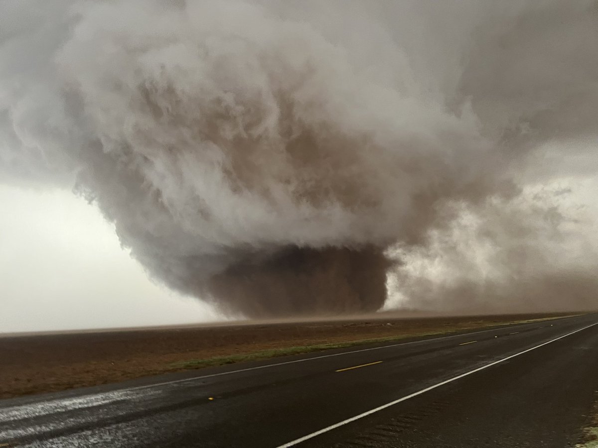
4 likes
Winter time post are almost exclusively focused on the DFW area.
-
bubba hotep
- S2K Supporter
- Posts: 6013
- Joined: Wed Dec 28, 2016 1:00 am
- Location: Collin County Texas
Re: Texas Spring 2022
pic credit @cpprstatestorms

4 likes
Winter time post are almost exclusively focused on the DFW area.
-
ElectricStorm

- Category 5
- Posts: 5141
- Age: 25
- Joined: Tue Aug 13, 2019 11:23 pm
- Location: Norman, OK
Re: Texas Spring 2022
What a monster... I hope that thing stays over open fields...
3 likes
B.S Meteorology, University of Oklahoma '25
Please refer to the NHC, NWS, or SPC for official information.
Please refer to the NHC, NWS, or SPC for official information.
-
bubba hotep
- S2K Supporter
- Posts: 6013
- Joined: Wed Dec 28, 2016 1:00 am
- Location: Collin County Texas
Re: Texas Spring 2022
Ntxw wrote:That cluster is heading towards DFW. Let's get the over early and monkey off our backs.
00z FWD sounding shows some dry midlevel air but minimal cap in place with decent CAPE. Storms stand a chance.
0 likes
Winter time post are almost exclusively focused on the DFW area.
Return to “USA & Caribbean Weather”
Who is online
Users browsing this forum: Iceresistance, rwfromkansas, Stratton23 and 304 guests