 the bigger event was always tomorrow
Texas Spring 2022
Moderator: S2k Moderators
Forum rules

The posts in this forum are NOT official forecast and should not be used as such. They are just the opinion of the poster and may or may not be backed by sound meteorological data. They are NOT endorsed by any professional institution or STORM2K.
-
Brent
- S2K Supporter

- Posts: 38729
- Age: 37
- Joined: Sun May 16, 2004 10:30 pm
- Location: Tulsa Oklahoma
- Contact:
Re: Texas Spring 2022
Rain has not stopped here. Actually popped a flood advisory. Last night the models had us mostly dry today the bigger event was always tomorrow
the bigger event was always tomorrow
0 likes
#neversummer
-
ElectricStorm

- Category 5

- Posts: 5140
- Age: 25
- Joined: Tue Aug 13, 2019 11:23 pm
- Location: Norman, OK
Re: Texas Spring 2022
This tornado in TX happened in a 2% tornado area and the severe watch lists EF2+ probs at just 5%. Goes to show that anything can happen even on the most marginal tornado setups
0 likes
B.S Meteorology, University of Oklahoma '25
Please refer to the NHC, NWS, or SPC for official information.
Please refer to the NHC, NWS, or SPC for official information.
-
bubba hotep

- S2K Supporter
- Posts: 6013
- Joined: Wed Dec 28, 2016 1:00 am
- Location: Collin County Texas
Re: Texas Spring 2022
00z HRRR has a huge MCS rolling across Texas tomorrow into tomorrow night.


1 likes
Winter time post are almost exclusively focused on the DFW area.


Re: Texas Spring 2022
bubba hotep wrote:00z HRRR has a huge MCS rolling across Texas tomorrow into tomorrow night.
https://m2o.pivotalweather.com/maps/models/hrrr/2022052400/031/refcmp.us_sc.png
https://m2o.pivotalweather.com/maps/models/hrrr/2022052400/036/qpf_acc.us_sc.png
Curious how the 2nd impulse from WTX pivots out. If timing is right the orientation could prolong more E-W vs N-S which would help drive up totals. If it happens further south obviously inverse effect.
0 likes
The above post and any post by Ntxw is NOT an official forecast and should not be used as such. It is just the opinion of the poster and may or may not be backed by sound meteorological data. It is NOT endorsed by any professional institution including Storm2k. For official information, please refer to NWS products.
Help support Storm2K!
-
South Texas Storms

- Professional-Met

- Posts: 4256
- Joined: Thu Jun 24, 2010 12:28 am
- Location: Houston, TX
Re: Texas Spring 2022
Looks like SA, Austin, and the Hill Country will miss out on tonight's round as storms developing over south TX will be disrupting inflow for the next disturbance moving out of Mexico. Sigh. That leaves one round for us tomorrow night. Hope that one can produce.
1 likes

Re: Texas Spring 2022
Almost on cue, all of that rain approaching DFW from the southwest evaporated basically over the Dallas/Tarrant county line. It feels like we're cursed.
0 likes
-
rwfromkansas
- Category 5
- Posts: 3021
- Joined: Sat Aug 27, 2005 12:47 am
- Location: North Fort Worth
Re: Texas Spring 2022
I got .10 of an inch before it evaporated. Maybe it will help at least moisten mid-levels further southwest?
0 likes

Re: Texas Spring 2022
So far this event has been very underwhelming. Hoping this last system overproduces but i highly doubt it.
1 likes

Re: Texas Spring 2022
The Flash Flood Watch for ETX into the Arklatex still seems like overkill to me. The HRRR and NAM3k showing generally 1"-2" across the area. Locally higher amounts possible, but the soils can handle quite a bit and it seems like the storms should generally be progressive in nature. At this point I'm just hoping I can get at least 1". With the squall line moving in near midnight it may be losing some steam. We shall see...
0 likes
-
bubba hotep
- S2K Supporter
- Posts: 6013
- Joined: Wed Dec 28, 2016 1:00 am
- Location: Collin County Texas
Re: Texas Spring 2022
Huge MCS off the coast of Texas in the Gulf that the models missed and a big outflow boundary moving out of the Panhandle. That should really help clear up today's rainfall forecast lol
0 likes
Winter time post are almost exclusively focused on the DFW area.
-
bubba hotep
- S2K Supporter
- Posts: 6013
- Joined: Wed Dec 28, 2016 1:00 am
- Location: Collin County Texas
Re: Texas Spring 2022
SPC has upgraded a pretty large area.

4 likes
Winter time post are almost exclusively focused on the DFW area.
-
Yukon Cornelius
- S2K Supporter
- Posts: 1838
- Age: 42
- Joined: Thu Dec 20, 2012 9:23 pm
- Location: Dean, TX/Westcliffe, CO
Re: Texas Spring 2022
In other news whopping +33 daily SOI. Have not seen a negative since April 3rd, quite significant streak for historical Springs.
Made a post prior about high SOI Springs that starts reversing in May for wet, cool summers. In real time, not happening.
Made a post prior about high SOI Springs that starts reversing in May for wet, cool summers. In real time, not happening.
0 likes
The above post and any post by Ntxw is NOT an official forecast and should not be used as such. It is just the opinion of the poster and may or may not be backed by sound meteorological data. It is NOT endorsed by any professional institution including Storm2k. For official information, please refer to NWS products.
Help support Storm2K!
Help support Storm2K!
-
HockeyTx82
- S2K Supporter
- Posts: 2782
- Joined: Tue Oct 27, 2009 11:17 am
- Location: Ponder, TX
Re: Texas Spring 2022
bubba hotep wrote:SPC has upgraded a pretty large area.
https://www.spc.noaa.gov/public/state/images/TX_swody1.png
Yup, and that monster Tornado west of Lubbock happened in a slight area with 2% chance. Any word on strength or size? That thing looked like a beast. Had that gone over populated areas. Oh my.
0 likes
Don't hold me accountable for anything I post on this forum. Leave the real forecasting up to the professionals.
Location: Ponder, TX (all observation posts are this location unless otherwise noted)
Location: Ponder, TX (all observation posts are this location unless otherwise noted)
-
Edwards Limestone

- S2K Supporter
- Posts: 508
- Age: 36
- Joined: Tue Dec 28, 2021 11:05 am
- Location: Smithson Valley, TX
Re: Texas Spring 2022
Majority of models are not handling this setup well at all. I knew we were doomed yesterday when EWX put out that forecast map showing wide swaths of 3-4" precip. 
I've received a whopping 0.05" for this event thus far. Yikes.
Also, LOL at EWX twitter:
https://twitter.com/NWSSanAntonio/status/1529065413941805057
I've received a whopping 0.05" for this event thus far. Yikes.
Also, LOL at EWX twitter:
https://twitter.com/NWSSanAntonio/status/1529065413941805057
1 likes
The above post is NOT an official forecast and should not be used as such. It is just the opinion of the poster and may or may not be backed by sound meteorological data. It is NOT endorsed by any professional institution including Storm2k. For official information, please refer to NWS products.
-
cheezyWXguy

- Category 5
- Posts: 6281
- Joined: Mon Feb 13, 2006 12:29 am
- Location: Dallas, TX
Re: Texas Spring 2022
HockeyTx82 wrote:bubba hotep wrote:SPC has upgraded a pretty large area.
https://www.spc.noaa.gov/public/state/images/TX_swody1.png
Yup, and that monster Tornado west of Lubbock happened in a slight area with 2% chance. Any word on strength or size? That thing looked like a beast. Had that gone over populated areas. Oh my.
Definitely huge, and likely pretty strong, but I have my doubts that it would have been an upper end monster in an urban area. The motion doesn’t look crazy violent in the videos I’ve seen, but it is easily the most photogenic wedge I’ve seen in a while, especially with all that loose dust in drought-stricken west Texas being easily lofted to define the full size of the tornado. Reminds me of a supersized Tescott 2018.
2 likes
-
bubba hotep
- S2K Supporter
- Posts: 6013
- Joined: Wed Dec 28, 2016 1:00 am
- Location: Collin County Texas
Re: Texas Spring 2022
Ntxw wrote:In other news whopping +33 daily SOI. Have not seen a negative since April 3rd, quite significant streak for historical Springs.
Made a post prior about high SOI Springs that starts reversing in May for wet, cool summers. In real time, not happening.
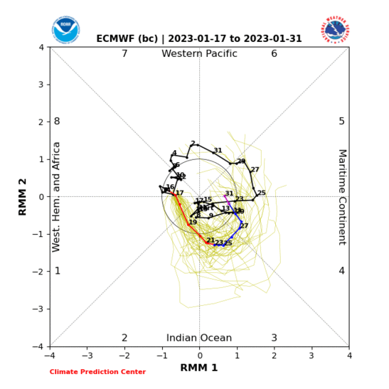
Rapid rise caused by the suppressed phase of the last CCKW and the background ENSO state? The next wave looks to be more coherent and MJO like vs the recent quick moving CCKW. I suspect we will see an uptick in svr wx across the Southern Plains as the MJO rotates into P8. This MJO could certainly pause any progression towards drought as June is typically a pretty wet month for a lot of Texas.
1 likes
Winter time post are almost exclusively focused on the DFW area.
-
bubba hotep
- S2K Supporter
- Posts: 6013
- Joined: Wed Dec 28, 2016 1:00 am
- Location: Collin County Texas
Re: Texas Spring 2022
We have been complaining about missing out on rain the last few days but some very beneficial rain has fallen in the Panhandle and Western Oklahoma.
2 likes
Winter time post are almost exclusively focused on the DFW area.
-
Brent
- S2K Supporter
- Posts: 38729
- Age: 37
- Joined: Sun May 16, 2004 10:30 pm
- Location: Tulsa Oklahoma
- Contact:
Re: Texas Spring 2022
Still raining here hasn't been much of a break since yesterday around lunch. Tulsa was approaching 8 inches for the month already
hasn't been much of a break since yesterday around lunch. Tulsa was approaching 8 inches for the month already
0 likes
#neversummer
Re: Texas Spring 2022
bubba hotep wrote:Ntxw wrote:In other news whopping +33 daily SOI. Have not seen a negative since April 3rd, quite significant streak for historical Springs.
Made a post prior about high SOI Springs that starts reversing in May for wet, cool summers. In real time, not happening.
Rapid rise caused by the suppressed phase of the last CCKW and the background ENSO state? The next wave looks to be more coherent and MJO like vs the recent quick moving CCKW. I suspect we will see an uptick in svr wx across the Southern Plains as the MJO rotates into P8. This MJO could certainly pause any progression towards drought as June is typically a pretty wet month for a lot of Texas.
https://www.cpc.ncep.noaa.gov/products/precip/CWlink/MJO/CLIVAR/ECMF_phase_MANOM_51m_small.gif
I hope so. Intraseasonal variability occurs, it's supposed to typically traverse the Pacific April-June even in Nina years (weakening ENSO.) The promises of those months delivering so far has not been the best grade. Lets hope that something changes in June. The background state hasn't changed. You're still looking at less than 27C over the tropical Pacific which is not ideal for sustained convection even when the CCKW/MJO passes over. We're entering the summer longwave pattern, these PVa digging eventually will be too far north.
After today's rain event, many of us will ride another 7-10 days of bone dry weather. That's been the killer too, underwhelming events for a lot and the intervals are far too long.
2 likes
The above post and any post by Ntxw is NOT an official forecast and should not be used as such. It is just the opinion of the poster and may or may not be backed by sound meteorological data. It is NOT endorsed by any professional institution including Storm2k. For official information, please refer to NWS products.
Help support Storm2K!
Help support Storm2K!
Return to “USA & Caribbean Weather”
Who is online
Users browsing this forum: Cpv17, Google [Bot], Stratton23 and 80 guests