2022 Indicators (SSTs/SAL/MSLP/Shear/Steering/Instability) and >Day 16 Models

This is the general tropical discussion area. Anyone can take their shot at predicting a storms path.

Moderator: S2k Moderators

Forum rules

The posts in this forum are NOT official forecasts and should not be used as such. They are just the opinion of the poster and may or may not be backed by sound meteorological data. They are NOT endorsed by any professional institution or STORM2K. For official information, please refer to products from the National Hurricane Center and National Weather Service.

Help Support Storm2K
Message
Author
User avatar
skyline385
Category 5
Category 5
Posts: 2728
Age: 35
Joined: Wed Aug 26, 2020 11:15 pm
Location: Houston TX

Re: 2022 Indicators (SSTs/SAL/MSLP/Shear/Steering/Instability) and >Day 16 Models

#1021 Postby skyline385 » Tue Jun 07, 2022 9:45 am

Stormybajan wrote:

Definitely a concerning trend with the CSU,ECMWF hyperactive forecasts AND the track into the lesser antilies..BUT I am still not ready to hop onto the hyperactive train yet, the MDR will continue to cool for the next 2 weeks before we see some sustained warming until the end of June- Early July. I believe July will tell us a lot,2005,2017,2020 ALL had active MDRs during the month of July coupled with strong AEWS. If the MDR warms more than usual then look out but right now I think "just" above average is the best bet. Hyperactivity in the Atlantic is a rarity for a reason 8-)

It is really odd that so many models seem to be pointing towards hyperactivity but the current SST just do not support that anywhere, especially when you compare them to previous hyperactive years.
2 likes   

User avatar
SFLcane
S2K Supporter
S2K Supporter
Posts: 10163
Age: 47
Joined: Sat Jun 05, 2010 1:44 pm
Location: Lake Worth Florida

Re: 2022 Indicators (SSTs/SAL/MSLP/Shear/Steering/Instability) and >Day 16 Models

#1022 Postby SFLcane » Tue Jun 07, 2022 9:57 am

skyline385 wrote:
Stormybajan wrote:

Definitely a concerning trend with the CSU,ECMWF hyperactive forecasts AND the track into the lesser antilies..BUT I am still not ready to hop onto the hyperactive train yet, the MDR will continue to cool for the next 2 weeks before we see some sustained warming until the end of June- Early July. I believe July will tell us a lot,2005,2017,2020 ALL had active MDRs during the month of July coupled with strong AEWS. If the MDR warms more than usual then look out but right now I think "just" above average is the best bet. Hyperactivity in the Atlantic is a rarity for a reason 8-)

It is really odd that so many models seem to be pointing towards hyperactivity but the current SST just do not support that anywhere, especially when you compare them to previous hyperactive years.


Either it will warm or the forecasts will bust. Those are basically the two options haha
5 likes   

User avatar
NotSparta
Professional-Met
Professional-Met
Posts: 1668
Age: 23
Joined: Fri Aug 18, 2017 8:24 am
Location: Naples, FL
Contact:

Re: 2022 Indicators (SSTs/SAL/MSLP/Shear/Steering/Instability) and >Day 16 Models

#1023 Postby NotSparta » Tue Jun 07, 2022 10:22 am

skyline385 wrote:Even on his own site, subtropics have warmed up during May

https://uploads.tapatalk-cdn.com/20220607/40717913605be0f333c10dedb1760f85.jpg


That's the problem with graphs. All that warming is where the NMME did not show cooling from last month's forecast
0 likes   
This post was probably an opinion of mine, and in no way is official. Please refer to http://www.hurricanes.gov for official tropical analysis and advisories.

My website, with lots of tropical wx graphics, including satellite and recon: http://cyclonicwx.com

User avatar
skyline385
Category 5
Category 5
Posts: 2728
Age: 35
Joined: Wed Aug 26, 2020 11:15 pm
Location: Houston TX

Re: 2022 Indicators (SSTs/SAL/MSLP/Shear/Steering/Instability) and >Day 16 Models

#1024 Postby skyline385 » Tue Jun 07, 2022 10:46 am

NotSparta wrote:
skyline385 wrote:Even on his own site, subtropics have warmed up during May

https://uploads.tapatalk-cdn.com/20220607/40717913605be0f333c10dedb1760f85.jpg


That's the problem with graphs. All that warming is where the NMME did not show cooling from last month's forecast

Between 30-45W where the NMME shows the most cooling, there is significant warming 30N and above in the last two weeks. For the region below 30N, it has pretty much remained the same. We might end up with the a warmer MDR but the current trends simply don't show it.
0 likes   

User avatar
SFLcane
S2K Supporter
S2K Supporter
Posts: 10163
Age: 47
Joined: Sat Jun 05, 2010 1:44 pm
Location: Lake Worth Florida

Re: 2022 Indicators (SSTs/SAL/MSLP/Shear/Steering/Instability) and >Day 16 Models

#1025 Postby SFLcane » Tue Jun 07, 2022 10:50 am

skyline385 wrote:
NotSparta wrote:
skyline385 wrote:Even on his own site, subtropics have warmed up during May

https://uploads.tapatalk-cdn.com/20220607/40717913605be0f333c10dedb1760f85.jpg


That's the problem with graphs. All that warming is where the NMME did not show cooling from last month's forecast

Between 30-45W where the NMME shows the most cooling, there is significant warming 30N and above in the last two weeks. For the region below 30N, it has pretty much remained the same. We might end up with the a warmer MDR but the current trends simply don't show it.


Its early June we have nearly 60 days if not more for Aug 20 when the cv season starts. I certainly think there is time for significant warming.
6 likes   

User avatar
DorkyMcDorkface
Category 3
Category 3
Posts: 888
Age: 27
Joined: Mon Sep 30, 2019 1:32 pm
Location: Mid-Atlantic

Re: 2022 Indicators (SSTs/SAL/MSLP/Shear/Steering/Instability) and >Day 16 Models

#1026 Postby DorkyMcDorkface » Tue Jun 07, 2022 10:53 am

SFLcane wrote:
skyline385 wrote:
NotSparta wrote:
That's the problem with graphs. All that warming is where the NMME did not show cooling from last month's forecast

Between 30-45W where the NMME shows the most cooling, there is significant warming 30N and above in the last two weeks. For the region below 30N, it has pretty much remained the same. We might end up with the a warmer MDR but the current trends simply don't show it.


Its early June we have nearly 60 days if not more for Aug 20 when the cv season starts. I certainly think there is time for significant warming.

You especially have to account for any warming initiated by the onset of the WAM/ASW which typically kicks into full gear later this month.
6 likes   
Please note the thougths expressed by this account are solely those of the user and are from a hobbyist perspective. For more comprehensive analysis, consult an actual professional meteorologist or meteorology agency.


Floyd 1999 | Isabel 2003 | Hanna 2008 | Irene 2011 | Sandy 2012 | Isaias 2020

User avatar
skyline385
Category 5
Category 5
Posts: 2728
Age: 35
Joined: Wed Aug 26, 2020 11:15 pm
Location: Houston TX

Re: 2022 Indicators (SSTs/SAL/MSLP/Shear/Steering/Instability) and >Day 16 Models

#1027 Postby skyline385 » Tue Jun 07, 2022 11:17 am

SFLcane wrote:
skyline385 wrote:
NotSparta wrote:
That's the problem with graphs. All that warming is where the NMME did not show cooling from last month's forecast

Between 30-45W where the NMME shows the most cooling, there is significant warming 30N and above in the last two weeks. For the region below 30N, it has pretty much remained the same. We might end up with the a warmer MDR but the current trends simply don't show it.


Its early June we have nearly 60 days if not more for Aug 20 when the cv season starts. I certainly think there is time for significant warming.

I agree with you that we have time for significant warming, July in particular will determine where we end up. However it is important to note that we are currently not trending towards the NMME output imo...
0 likes   

User avatar
toad strangler
S2K Supporter
S2K Supporter
Posts: 4543
Joined: Sun Jul 28, 2013 3:09 pm
Location: Earth
Contact:

Re: 2022 Indicators (SSTs/SAL/MSLP/Shear/Steering/Instability) and >Day 16 Models

#1028 Postby toad strangler » Tue Jun 07, 2022 11:20 am

SST handwringing 101 in it's natural habitat :D

Seriously though, the WAM is modeled to be quite active which will in turn spit out those AEW's. For for the most part said AEW's marching out of an active WAM will move along generally westward regardless of SST's. This is the kind of year (projected) that we can end up with more waves than normal finding the Western half of the basin and then BOOM.
6 likes   

User avatar
SFLcane
S2K Supporter
S2K Supporter
Posts: 10163
Age: 47
Joined: Sat Jun 05, 2010 1:44 pm
Location: Lake Worth Florida

Re: 2022 Indicators (SSTs/SAL/MSLP/Shear/Steering/Instability) and >Day 16 Models

#1029 Postby SFLcane » Tue Jun 07, 2022 11:23 am

DorkyMcDorkface wrote:
SFLcane wrote:
skyline385 wrote:Between 30-45W where the NMME shows the most cooling, there is significant warming 30N and above in the last two weeks. For the region below 30N, it has pretty much remained the same. We might end up with the a warmer MDR but the current trends simply don't show it.


Its early June we have nearly 60 days if not more for Aug 20 when the cv season starts. I certainly think there is time for significant warming.

You especially have to account for any warming initiated by the onset of the WAM/ASW which typically kicks into full gear later this month.


It better if the Atlantic is gonna get there.
0 likes   

AlphaToOmega
Category 5
Category 5
Posts: 1448
Joined: Sat Jun 26, 2021 10:51 am
Location: Somewhere in Massachusetts

Re: 2022 Indicators (SSTs/SAL/MSLP/Shear/Steering/Instability) and >Day 16 Models

#1030 Postby AlphaToOmega » Tue Jun 07, 2022 2:47 pm

skyline385 wrote:
SFLcane wrote:
skyline385 wrote:Between 30-45W where the NMME shows the most cooling, there is significant warming 30N and above in the last two weeks. For the region below 30N, it has pretty much remained the same. We might end up with the a warmer MDR but the current trends simply don't show it.


Its early June we have nearly 60 days if not more for Aug 20 when the cv season starts. I certainly think there is time for significant warming.

I agree with you that we have time for significant warming, July in particular will determine where we end up. However it is important to note that we are currently not trending towards the NMME output imo...


The MDR has always warmed from May to September ever since 2012 due to WAM, and there is no reason to think that would stop with 2022.
2 likes   

User avatar
LemieT
Tropical Depression
Tropical Depression
Posts: 78
Age: 40
Joined: Sun Jun 13, 2021 5:31 pm
Location: Barbados

Re: 2022 Indicators (SSTs/SAL/MSLP/Shear/Steering/Instability) and >Day 16 Models

#1031 Postby LemieT » Tue Jun 07, 2022 3:41 pm

Stormybajan wrote:

Definitely a concerning trend with the CSU,ECMWF hyperactive forecasts AND the track into the lesser antilies..BUT I am still not ready to hop onto the hyperactive train yet, the MDR will continue to cool for the next 2 weeks before we see some sustained warming until the end of June- Early July. I believe July will tell us a lot,2005,2017,2020 ALL had active MDRs during the month of July coupled with strong AEWS. If the MDR warms more than usual then look out but right now I think "just" above average is the best bet. Hyperactivity in the Atlantic is a rarity for a reason 8-)


This is basically the way I see it as well. I went active in my numbers for the poll but refrained from hyperactive train. Not seeing the parameters aligned just yet. Models cannot be discounted but I want to see some more evidence first. Like you said, The end of this month and July will let us know what's up.
1 likes   


User avatar
Tampa Bay Hurricane
Category 5
Category 5
Posts: 5597
Age: 37
Joined: Fri Jul 22, 2005 7:54 pm
Location: St. Petersburg, FL

Re: 2022 Indicators (SSTs/SAL/MSLP/Shear/Steering/Instability) and >Day 16 Models

#1034 Postby Tampa Bay Hurricane » Tue Jun 07, 2022 11:39 pm

This hurricane season has me very concerned for Florida- We had that no name system hit the panhandle in May, and then Pre Alex flooded South Florida last week. These early season tracks indicate persistent gulf troughing and a ridge sufficient enough to push tropical waves to our longitude. This is very similar to what we experienced in 2004 in May/June.
0 likes   

User avatar
skyline385
Category 5
Category 5
Posts: 2728
Age: 35
Joined: Wed Aug 26, 2020 11:15 pm
Location: Houston TX

Re: 2022 Indicators (SSTs/SAL/MSLP/Shear/Steering/Instability) and >Day 16 Models

#1035 Postby skyline385 » Wed Jun 08, 2022 7:32 am

Tampa Bay Hurricane wrote:This hurricane season has me very concerned for Florida- We had that no name system hit the panhandle in May, and then Pre Alex flooded South Florida last week. These early season tracks indicate persistent gulf troughing and a ridge sufficient enough to push tropical waves to our longitude. This is very similar to what we experienced in 2004 in May/June.

2004 had the first storm on July 31 though
0 likes   

Nuno
Category 2
Category 2
Posts: 597
Joined: Fri Aug 30, 2019 8:35 am
Location: Coral Gables, FL

Re: 2022 Indicators (SSTs/SAL/MSLP/Shear/Steering/Instability) and >Day 16 Models

#1036 Postby Nuno » Wed Jun 08, 2022 9:28 am

skyline385 wrote:
Tampa Bay Hurricane wrote:This hurricane season has me very concerned for Florida- We had that no name system hit the panhandle in May, and then Pre Alex flooded South Florida last week. These early season tracks indicate persistent gulf troughing and a ridge sufficient enough to push tropical waves to our longitude. This is very similar to what we experienced in 2004 in May/June.

2004 had the first storm on July 31 though


I think Tampa Bay Hurricane means that the general set up is similar to 2004 in early summer despite not having had a named storm until 7/31. Technically florida hasn't had a named storm landfall yet either so far :ggreen:

Also, SSTs will be warm enough to support a hyperactive season if the conditions warrant it. SSTs are the least of the problems any forming cyclones may face during most NATL seasons when compared to stability, dry air, shear, etc.
2 likes   
Andrew (1992), Irene (1999), Frances (2004), Katrina (2005), Wilma (2005), Fay (2008), Irma (2017), Eta (2020), Ian (2022)

User avatar
cycloneye
Admin
Admin
Posts: 145299
Age: 68
Joined: Thu Oct 10, 2002 10:54 am
Location: San Juan, Puerto Rico

Re: 2022 Indicators (SSTs/SAL/MSLP/Shear/Steering/Instability) and >Day 16 Models

#1037 Postby cycloneye » Wed Jun 08, 2022 9:33 am

July will be the key month to see where all the factors stand and see if 2022 will be active but not hyperactive or will be the contrary.
0 likes   
Visit the Caribbean-Central America Weather Thread where you can find at first post web cams,radars
and observations from Caribbean basin members Click Here

User avatar
SFLcane
S2K Supporter
S2K Supporter
Posts: 10163
Age: 47
Joined: Sat Jun 05, 2010 1:44 pm
Location: Lake Worth Florida

Re: 2022 Indicators (SSTs/SAL/MSLP/Shear/Steering/Instability) and >Day 16 Models

#1038 Postby SFLcane » Wed Jun 08, 2022 9:34 am

Tampa Bay Hurricane wrote:This hurricane season has me very concerned for Florida- We had that no name system hit the panhandle in May, and then Pre Alex flooded South Florida last week. These early season tracks indicate persistent gulf troughing and a ridge sufficient enough to push tropical waves to our longitude. This is very similar to what we experienced in 2004 in May/June.


Yeah but that's just June climo. Doesn't really say anything about tracks later. 2004 didn't have anything here early.
0 likes   

User avatar
SFLcane
S2K Supporter
S2K Supporter
Posts: 10163
Age: 47
Joined: Sat Jun 05, 2010 1:44 pm
Location: Lake Worth Florida

Re: 2022 Indicators (SSTs/SAL/MSLP/Shear/Steering/Instability) and >Day 16 Models

#1039 Postby SFLcane » Wed Jun 08, 2022 9:42 am

Nuno wrote:
skyline385 wrote:
Tampa Bay Hurricane wrote:This hurricane season has me very concerned for Florida- We had that no name system hit the panhandle in May, and then Pre Alex flooded South Florida last week. These early season tracks indicate persistent gulf troughing and a ridge sufficient enough to push tropical waves to our longitude. This is very similar to what we experienced in 2004 in May/June.

2004 had the first storm on July 31 though


I think Tampa Bay Hurricane means that the general set up is similar to 2004 in early summer despite not having had a named storm until 7/31. Technically florida hasn't had a named storm landfall yet either so far :ggreen:

Also, SSTs will be warm enough to support a hyperactive season if the conditions warrant it. SSTs are the least of the problems any forming cyclones may face during most NATL seasons when compared to stability, dry air, shear, etc.


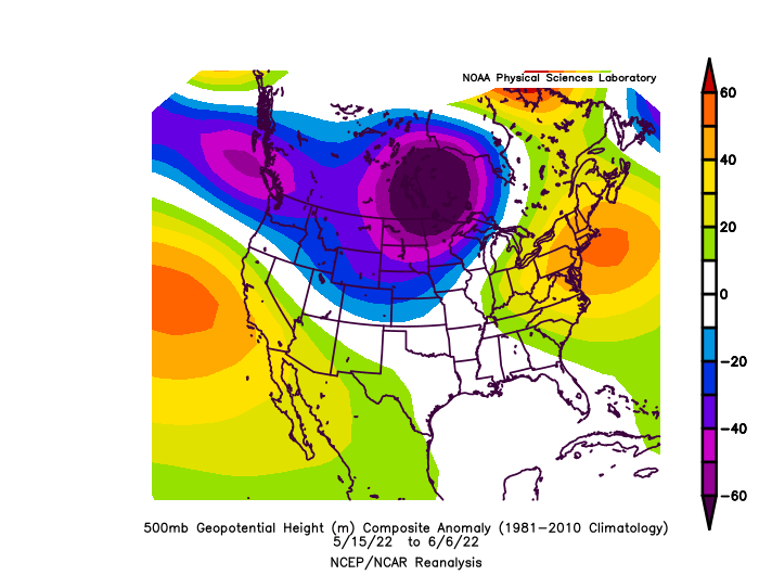
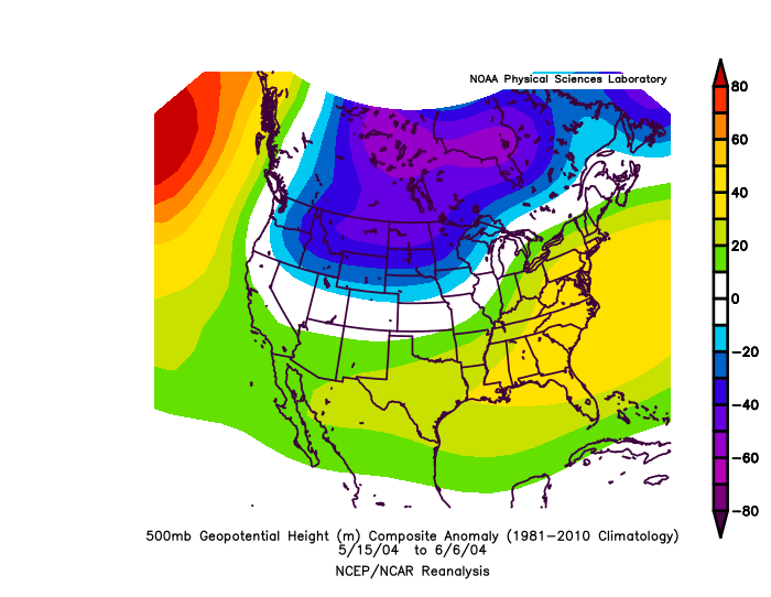
Similar how?

The 500-mb pattern is rather different

Image

Image
0 likes   

User avatar
SFLcane
S2K Supporter
S2K Supporter
Posts: 10163
Age: 47
Joined: Sat Jun 05, 2010 1:44 pm
Location: Lake Worth Florida

Re: 2022 Indicators (SSTs/SAL/MSLP/Shear/Steering/Instability) and >Day 16 Models

#1040 Postby SFLcane » Wed Jun 08, 2022 9:44 am

Taken a glance at long range guidance this morning the Euro/CFS are showing a pattern that avoids Florida. Its early so we will see if that changes
0 likes   


Return to “Talkin' Tropics”

Who is online

Users browsing this forum: Jymmybob, Pas_Bon and 39 guests