
This felt like more of a discussion topic so I'm putting it here because there may not be any kind of definitive answer to it. I will say that this may have some simple answer and I'm just not smart enough to figure it out but if that's not the case then here's the discussion topic:
I've seen a number of people look at some storms and say they have perfect structures and look on IR and whatnot. Many people say these are contenders for the most intense tropical cyclone on record. If an estimate is given, it will likely be 185kt. So that made me wonder, if that's perfect, what's beyond perfect?
What would a 200kt storm look like? Would it look better than, say, Patricia? Could it look better? Without aircraft recon, would we be able to notice that the storm was clearly much more powerful than anything on record? And even if people did notice, would they say it was 200kt? Would they even think it was 200kt? 15kt is a significant jump in intensity from 185kt, with a pressure likely in the 850s-840s range, and for a difference between say, 140kt and 155kt, it's probably pretty noticeable, but I don't think it would be the same for 185kt vs 200kt.
Now I do realize that this kind of storm might not even be possible with Earth's current climate, but it's still a curiosity.
What would a 200kt (1-min sustained) TC look like?
Moderator: S2k Moderators
Forum rules

The posts in this forum are NOT official forecasts and should not be used as such. They are just the opinion of the poster and may or may not be backed by sound meteorological data. They are NOT endorsed by any professional institution or STORM2K. For official information, please refer to products from the National Hurricane Center and National Weather Service.
-
tolakram
- Admin

- Posts: 20186
- Age: 62
- Joined: Sun Aug 27, 2006 8:23 pm
- Location: Florence, KY (name is Mark)
Re: What would a 200kt (1-min sustained) TC look like?
Knots? 200 kts = 230 mph (* 1.151 to convert).
a 200 mph storm = 173 kts
I don't think what you are saying is possible though I don't understand the atmospheric limits. My guess is a 200? storm would look exactly like a 185? storm, maybe with higher cloud tops.
a 200 mph storm = 173 kts
I don't think what you are saying is possible though I don't understand the atmospheric limits. My guess is a 200? storm would look exactly like a 185? storm, maybe with higher cloud tops.
0 likes
M a r k
- - - - -
Join us in chat: Storm2K Chatroom Invite. Android and IOS apps also available.
The posts in this forum are NOT official forecasts and should not be used as such. Posts are NOT endorsed by any professional institution or STORM2K.org. For official information and forecasts, please refer to NHC and NWS products.
-
InfernoFlameCat

- Category 5

- Posts: 2127
- Age: 23
- Joined: Mon Dec 14, 2020 10:52 am
- Location: Buford, GA
Re: What would a 200kt storm look like?
Foxfires wrote:This felt like more of a discussion topic so I'm putting it here because there may not be any kind of definitive answer to it. I will say that this may have some simple answer and I'm just not smart enough to figure it out but if that's not the case then here's the discussion topic:
I've seen a number of people look at some storms and say they have perfect structures and look on IR and whatnot. Many people say these are contenders for the most intense tropical cyclone on record. If an estimate is given, it will likely be 185kt. So that made me wonder, if that's perfect, what's beyond perfect?
What would a 200kt storm look like? Would it look better than, say, Patricia? Could it look better? Without aircraft recon, would we be able to notice that the storm was clearly much more powerful than anything on record? And even if people did notice, would they say it was 200kt? Would they even think it was 200kt? 15kt is a significant jump in intensity from 185kt, with a pressure likely in the 850s-840s range, and for a difference between say, 140kt and 155kt, it's probably pretty noticeable, but I don't think it would be the same for 185kt vs 200kt.
Now I do realize that this kind of storm might not even be possible with Earth's current climate, but it's still a curiosity.
I would expect a large storm. It would be tall enough to reach into the stratosphere and would have a pressure around 850mb. Waters would need to be around 34+C. The clouds would be so high up they would be warmer than the surrounding outflow. This is because the stratosphere is warmer than the troposphere. The storm would wreck our ozone layers most likely. It would devastate inland communities and erase communities like a 20 mile wide EF5 tornado moved through. Not many people would die directly because they would evacuate en mass. However, many would likely die from car crashes from people fleeing the storm. Storm surge could be anywhere from 30 ft to 50ft depending on the landfall location and size of the storm. The system itself would remain a Cat 5 well past landfall due to it bringing water in with it as well as having a while to fall below Cat 5 status (60 knots to be precise). It would be devastating for many miles inland. It would likely remain a hurricane for at least a day past landfall, maybe even two. Yeah, let’s hope that never happens lol.
2 likes
I am by no means a professional. DO NOT look at my forecasts for official information or make decisions based on what I post.
Goal: to become a registered expert over tropical and subtropical cyclones.
Goal: to become a registered expert over tropical and subtropical cyclones.
-
skyline385

- Category 5
- Posts: 2728
- Age: 35
- Joined: Wed Aug 26, 2020 11:15 pm
- Location: Houston TX
-
Category5Kaiju

- Category 5
- Posts: 4347
- Joined: Thu Dec 24, 2020 12:45 pm
- Location: Seattle during the summer, Phoenix during the winter
Re: What would a 200kt (1-min sustained) TC look like?
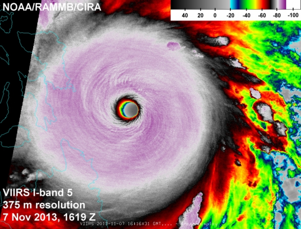

Probably would look something like these
5 likes
Unless explicitly stated, all information in my posts is based on my own opinions and observations. Tropical storms and hurricanes can be extremely dangerous. Refer to an accredited weather research agency or meteorologist if you need to make serious decisions regarding an approaching storm.

Re: What would a 200kt (1-min sustained) TC look like?
tolakram wrote:Knots? 200 kts = 230 mph (* 1.151 to convert).
a 200 mph storm = 173 kts
I don't think what you are saying is possible though I don't understand the atmospheric limits. My guess is a 200? storm would look exactly like a 185? storm, maybe with higher cloud tops.
Patrica reached 215 mph in the eastern Pacific, so I'd say that 230 mph is definitely possible. It would most likely need to be a storm in the western pacific under extremely favorable conditions for nearly its entire life cycle. We've seen plenty of west pacific monsters that were almost certainly more powerful than officially recorded due to lack of recon.
0 likes
Who is online
Users browsing this forum: bird, Google Adsense [Bot] and 135 guests