See you mid July. Nothing atypical. Suppressed MJO phase typically means more SAL/trade surges we'll see if our warm MDR holds up.
https://twitter.com/AndyHazelton/status/1542131737098129408
2022 Indicators (SSTs/SAL/MSLP/Shear/Steering/Instability) and >Day 16 Models
Moderator: S2k Moderators
Forum rules

The posts in this forum are NOT official forecasts and should not be used as such. They are just the opinion of the poster and may or may not be backed by sound meteorological data. They are NOT endorsed by any professional institution or STORM2K. For official information, please refer to products from the National Hurricane Center and National Weather Service.

Re: 2022 Indicators (SSTs/SAL/MSLP/Shear/Steering/Instability) and >Day 16 Models
SFLcane wrote:See you mid July. Nothing atypical. Suppressed MJO phase typically means more SAL/trade surges we'll see if our warm MDR holds up.
https://twitter.com/AndyHazelton/status/1542131737098129408?s=20&t=T9qyiH-Si-Ig3euF38yr9Q
Probably nothing until late July or maybe even as late as mid August. I remember last year, it was thought that activity would resume in late July once the suppressive MJO phase finally started to leave, but it took another few weeks for the Atlantic to be able to produce anything. A similar situation may unfold this year too.
Edit: almost forgot, aren’t the models also showing a strong CCKW at the end of the month?
1 likes
Irene '11 Sandy '12 Hermine '16 5/15/2018 Derecho Fay '20 Isaias '20 Elsa '21 Henri '21 Ida '21
I am only a meteorology enthusiast who knows a decent amount about tropical cyclones. Look to the professional mets, the NHC, or your local weather office for the best information.
I am only a meteorology enthusiast who knows a decent amount about tropical cyclones. Look to the professional mets, the NHC, or your local weather office for the best information.
-
skyline385

- Category 5

- Posts: 2728
- Age: 35
- Joined: Wed Aug 26, 2020 11:15 pm
- Location: Houston TX
Re: 2022 Indicators (SSTs/SAL/MSLP/Shear/Steering/Instability) and >Day 16 Models
aspen wrote:SFLcane wrote:See you mid July. Nothing atypical. Suppressed MJO phase typically means more SAL/trade surges we'll see if our warm MDR holds up.
https://twitter.com/AndyHazelton/status/1542131737098129408?s=20&t=T9qyiH-Si-Ig3euF38yr9Q
Probably nothing until late July or maybe even as late as mid August. I remember last year, it was thought that activity would resume in late July once the suppressive MJO phase finally started to leave, but it took another few weeks for the Atlantic to be able to produce anything. A similar situation may unfold this year too.
Edit: almost forgot, aren’t the models also showing a strong CCKW at the end of the month?
Check my post above, Andy talks about the CCKW
0 likes
-
skyline385
- Category 5
- Posts: 2728
- Age: 35
- Joined: Wed Aug 26, 2020 11:15 pm
- Location: Houston TX
Re: 2022 Indicators (SSTs/SAL/MSLP/Shear/Steering/Instability) and >Day 16 Models
Updates from today’s midday CFS run:
— With the exception of a TS traveling from 40W to 60W around July 24-27th, the next 6-7 weeks are quiet due to the suppressive MJO phase and some time afterwards for the Atlantic to recover
—MDR activity begins with a western MDR storm that forms on 8/18, passes over the NE Caribbean islands and Bahamas over the next few days, and recurves close to the East Coast near the end of the month
—Two more MDR storms follow on 8/27 and 8/31, respectively. The first hits the NECar again and RIs around Bermuda on 9/8, the second recurves harmlessly OTS thanks to a break in the ridge caused by the 8/18 storm, which sticks around in the subtropics
—Another, very brief MDR storm forms on 9/10 and recurves, similar to Rene ‘20
—Final MDR storm forms on 9/12 and goes due west into the Caribbean (9/17) before turning north into the Greater Antilles and Bahamas (9/19 and 9/20)
TL;DR — pretty much nothing else after PTC2/Bonnie thanks to the 2021-esqe suppressive phase until mid-August, when the MDR goes nuts. The CFS has been rather persistent with the idea of an Earl ‘10/Irene ‘11 East Coast scraper in the second half of August for the last several days. While it has been spot-on with some storms in its long-range forecast like Isaias, Laura, and Ida, I’d take this with a healthy dose of skepticism. Still, the pattern this predicts until mid-September (suppressed 1.5 months before a busy peak starting in mid-late August) seems quite reasonable.
1 likes
Irene '11 Sandy '12 Hermine '16 5/15/2018 Derecho Fay '20 Isaias '20 Elsa '21 Henri '21 Ida '21
I am only a meteorology enthusiast who knows a decent amount about tropical cyclones. Look to the professional mets, the NHC, or your local weather office for the best information.
I am only a meteorology enthusiast who knows a decent amount about tropical cyclones. Look to the professional mets, the NHC, or your local weather office for the best information.
-
cycloneye

- Admin

- Posts: 149727
- Age: 69
- Joined: Thu Oct 10, 2002 10:54 am
- Location: San Juan, Puerto Rico
Re: 2022 Indicators (SSTs/SAL/MSLP/Shear/Steering/Instability) and >Day 16 Models
aspen, moved your CFS post from the models discussion 16 day thread to this one.
0 likes
Visit the Caribbean-Central America Weather Thread where you can find at first post web cams,radars
and observations from Caribbean basin members Click Here
and observations from Caribbean basin members Click Here
-
skyline385
- Category 5
- Posts: 2728
- Age: 35
- Joined: Wed Aug 26, 2020 11:15 pm
- Location: Houston TX
2022 Indicators (SSTs/SAL/MSLP/Shear/Steering/Instability) and >Day 16 Models
Big doubt on this, there is nothing on the long range ensembles and we already know the Atlantic is going through a strong suppressed phase from the MJO and the CCKW.
Last edited by skyline385 on Thu Jun 30, 2022 10:13 am, edited 1 time in total.
0 likes
-
NXStumpy_Robothing
- Category 1

- Posts: 335
- Age: 25
- Joined: Fri Jun 05, 2020 11:50 pm
- Location: North Georgia
Re: 2022 Indicators (SSTs/SAL/MSLP/Shear/Steering/Instability) and >Day 16 Models
skyline385 wrote:
Big doubt on this, there is nothing in the long range ensembles and we already know the Atlantic is going through a strong suppressed phase from the MJO and the CCKW.
Said long-range ensembles only go out 384 hours (if you're looking at the GEFS, GEPS, or ECENS), which only takes you to July 16th or so. I wouldn't really consider that a deep dive into the second half of July. Furthermore, this tweet doesn't dispute the second part of your statement anyway, and the gif in fact supports this well-forecasted suppressed phase over the Atlantic in the short-term. In addition, the general shift back into favorability as we approach the heart of the season is consistent with typical La Nina seasons and intraseasonal variability.
8 likes
Undergraduate Meteorology Student, Georgia Institute of Technology
-
toad strangler

- S2K Supporter

- Posts: 4546
- Joined: Sun Jul 28, 2013 3:09 pm
- Location: Earth
- Contact:
Re: 2022 Indicators (SSTs/SAL/MSLP/Shear/Steering/Instability) and >Day 16 Models
NXStumpy_Robothing wrote:skyline385 wrote:
Big doubt on this, there is nothing in the long range ensembles and we already know the Atlantic is going through a strong suppressed phase from the MJO and the CCKW.
Said long-range ensembles only go out 384 hours (if you're looking at the GEFS, GEPS, or ECENS), which only takes you to July 16th or so. I wouldn't really consider that a deep dive into the second half of July. Furthermore, this tweet doesn't dispute the second part of your statement anyway, and the gif in fact supports this well-forecasted suppressed phase over the Atlantic in the short-term. In addition, the general shift back into favorability as we approach the heart of the season is consistent with typical La Nina seasons and intraseasonal variability.
word
Ben is someone I have in my in my pro met long range indicator favorites. I don't post the tweet links here much anymore but I do take notice and I would place an affordable bet on the latter half of July becoming more favorable if Noll sees it. Does this mean a switch flip? Nah that's probably not the context of his tweet. Overall favorability is the glimpse ..
2 likes
My Weather Station
https://www.wunderground.com/dashboard/pws/KFLPORTS603
https://www.wunderground.com/dashboard/pws/KFLPORTS603
-
Kingarabian

- S2K Supporter
- Posts: 16379
- Joined: Sat Aug 08, 2009 3:06 am
- Location: Honolulu, Hawaii
Re: 2022 Indicators (SSTs/SAL/MSLP/Shear/Steering/Instability) and >Day 16 Models
Second half of July is very likely to be active. Easily see it on the models that have long range 850mb wind and 200mb wind forecasts. There should be ample westerly anomalies for the entire MDR while 200m easterlies are favored at the same time.
4 likes
RIP Kobe Bryant
-
skyline385
- Category 5
- Posts: 2728
- Age: 35
- Joined: Wed Aug 26, 2020 11:15 pm
- Location: Houston TX
Re: 2022 Indicators (SSTs/SAL/MSLP/Shear/Steering/Instability) and >Day 16 Models
NXStumpy_Robothing wrote:skyline385 wrote:
Big doubt on this, there is nothing in the long range ensembles and we already know the Atlantic is going through a strong suppressed phase from the MJO and the CCKW.
Said long-range ensembles only go out 384 hours (if you're looking at the GEFS, GEPS, or ECENS), which only takes you to July 16th or so. I wouldn't really consider that a deep dive into the second half of July. Furthermore, this tweet doesn't dispute the second part of your statement anyway, and the gif in fact supports this well-forecasted suppressed phase over the Atlantic in the short-term. In addition, the general shift back into favorability as we approach the heart of the season is consistent with typical La Nina seasons and intraseasonal variability.
That was my bad, i read the tweet as second week of July. Also there are still the 35-day GEFS and 45-day EPS which are not showing anything but obviously those can’t be trusted. Like i said, i misread and thought he was talking about the 2nd week of July.
3 likes
-
skyline385
- Category 5
- Posts: 2728
- Age: 35
- Joined: Wed Aug 26, 2020 11:15 pm
- Location: Houston TX
-
IsabelaWeather
- Category 1
- Posts: 316
- Age: 36
- Joined: Tue Jul 07, 2020 7:29 am
- Location: Isabela, Puerto Rico
Re: 2022 Indicators (SSTs/SAL/MSLP/Shear/Steering/Instability) and >Day 16 Models
Curious on why the WPAC has much colder cloud tops than the Atl? I was looking at Chaba and the amount of -80C cloud tops is insane, you dont see this very often in the ATL but its at the same latitude as the caribbean is so it can't be a higher tropopause.
https://www.tropicaltidbits.com/sat/satlooper.php?region=04W&product=ir
https://www.tropicaltidbits.com/sat/satlooper.php?region=04W&product=ir
1 likes
Re: 2022 Indicators (SSTs/SAL/MSLP/Shear/Steering/Instability) and >Day 16 Models
IsabelaWeather wrote:Curious on why the WPAC has much colder cloud tops than the Atl? I was looking at Chaba and the amount of -80C cloud tops is insane, you dont see this very often in the ATL but its at the same latitude as the caribbean is so it can't be a higher tropopause.
https://www.tropicaltidbits.com/sat/satlooper.php?region=04W&product=ir
WPAC does have a higher tropopause. They are at the same latitude doesn't mean they have the same tropopause height.
2 likes
-
cycloneye
- Admin
- Posts: 149727
- Age: 69
- Joined: Thu Oct 10, 2002 10:54 am
- Location: San Juan, Puerto Rico
Re: 2022 Indicators (SSTs/SAL/MSLP/Shear/Steering/Instability) and >Day 16 Models
0 likes
Visit the Caribbean-Central America Weather Thread where you can find at first post web cams,radars
and observations from Caribbean basin members Click Here
and observations from Caribbean basin members Click Here
-
skyline385
- Category 5
- Posts: 2728
- Age: 35
- Joined: Wed Aug 26, 2020 11:15 pm
- Location: Houston TX
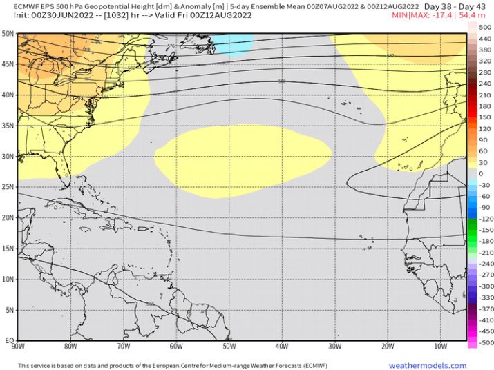
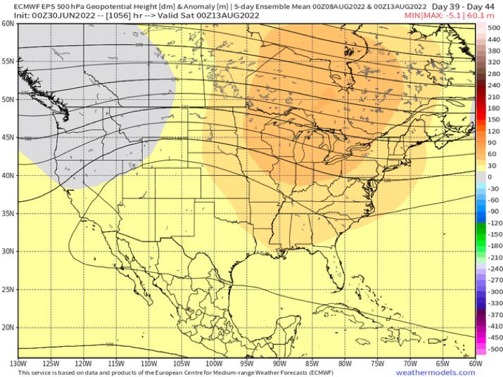
2022 Indicators (SSTs/SAL/MSLP/Shear/Steering/Instability) and >Day 16 Models
So much sinking air in the west Atlantic even in early August
Interestingly enough, both the EPS and GEFS control members hint at possible activity for a small period in early July.


0 likes
-
SFLcane

- S2K Supporter
- Posts: 10281
- Age: 48
- Joined: Sat Jun 05, 2010 1:44 pm
- Location: Lake Worth Florida
Re: 2022 Indicators (SSTs/SAL/MSLP/Shear/Steering/Instability) and >Day 16 Models
Um we gonna have some problems if this happens!
0 likes
Re: 2022 Indicators (SSTs/SAL/MSLP/Shear/Steering/Instability) and >Day 16 Models
skyline385 wrote:SFLcane wrote::crazyeyes:
https://twitter.com/andyhazelton/status/1542613241033015297?s=21&t=ZKGGX1SB0JeBuKdoV1-8aw
So much sinking air in the west Atlantic even in early August
Interestingly enough, both the EPS and GEFS control members hint at possible activity for a small period in early July.
https://uploads.tapatalk-cdn.com/20220630/43fc65fd64f7bef7ea05fac38d62c182.jpg
https://uploads.tapatalk-cdn.com/20220630/c6b431cdeb9482fcb27013f550b708b2.jpg
Looks like there’s also a weak enhanced CCKW in the EPac and western Atlantic around July 16-21st, then lots of rising air over the EPac for the rest of the month with small bursts of Atlantic rising air around July 26th and August 1st. Not great for the Atlantic — I’d bet the EPac would be more active — but we could get a storm or two.
0 likes
Irene '11 Sandy '12 Hermine '16 5/15/2018 Derecho Fay '20 Isaias '20 Elsa '21 Henri '21 Ida '21
I am only a meteorology enthusiast who knows a decent amount about tropical cyclones. Look to the professional mets, the NHC, or your local weather office for the best information.
I am only a meteorology enthusiast who knows a decent amount about tropical cyclones. Look to the professional mets, the NHC, or your local weather office for the best information.
Who is online
Users browsing this forum: Google Adsense [Bot], Iceresistance and 103 guests