Category5Kaiju wrote:Not sure how much bearing this observation may have for this season, but one major difference that seems already apparent compared to 2020 and 2021 (and the last several recent seasons, especially dating back to 2016) is how the subtropics seem cooler than average while the deep tropics are warmer. Perhaps this may be a factor in why early-season storms are struggling or not happening as often as expected? On the other hand, I do think this setup may actually give 2022 a leg up from previous years in how we could perhaps see much more intense, deep tropical activity later in the season. Now in terms of named storms, I still think it's way too early to make conclusions considering how there have been La Nina seasons in the past (namely 2010) that did not feature many storms early on but made up for that deficit once October and November rolled around
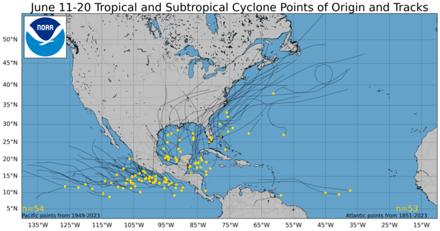
Early season activity is just that, rare. Even using recent climatology (1991-2020), the average first named system is June 10th (the second named system is July 17th). The below graphics are lacking a few recent years, but look at all storms from 1851-2015 for the entire month of June: It's extremely anomalous to have a system develop in the MDR or eastern Caribbean in June.

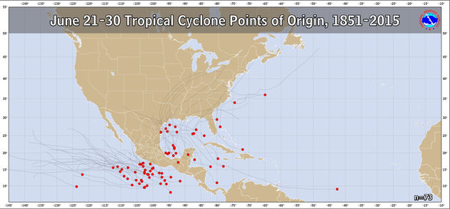
Almost all activity in June is exclusively concentrated in the GOM, western Caribbean, or off the east coast (and most originate from scenarios like 95L vs. PTC2). Even if looking at a penultimate season in the recent satellite era (i.e., 2005), early season activity was limited in June (Arlene was June 10th, Bret was June 24th) and occurred in the western Caribbean and GOM. Hurricane Dennis and Emily formed in the first and second weeks of July, and it was really the central/western Caribbean where they reached peak intensity. 2005 had some off-the-chart zonal wind anomalies in this region for the first 2 weeks of July:

For most systems, and PTC2 in particular, it is difficult to overcome the trade wind bursts as they enter the Caribbean. More specifically, when a poorly defined system that lacks a strong vort max enters the Caribbean, the wave axis also undergoes certain characteristics (namely the wave axis goes from positively tilted to negatively tilted due to the earth's axis/rotation). A recent example is a snapshot of PTC2 as it enters the Caribbean, using EarthNull and tracking winds at 850mb you can see how destructive the flow is for a weak/poorly defined system:


