IsabelaWeather wrote:weeniepatrol wrote:weeniepatrol wrote:
SSTs are not everything
This is just one piece of the puzzle, but for example...
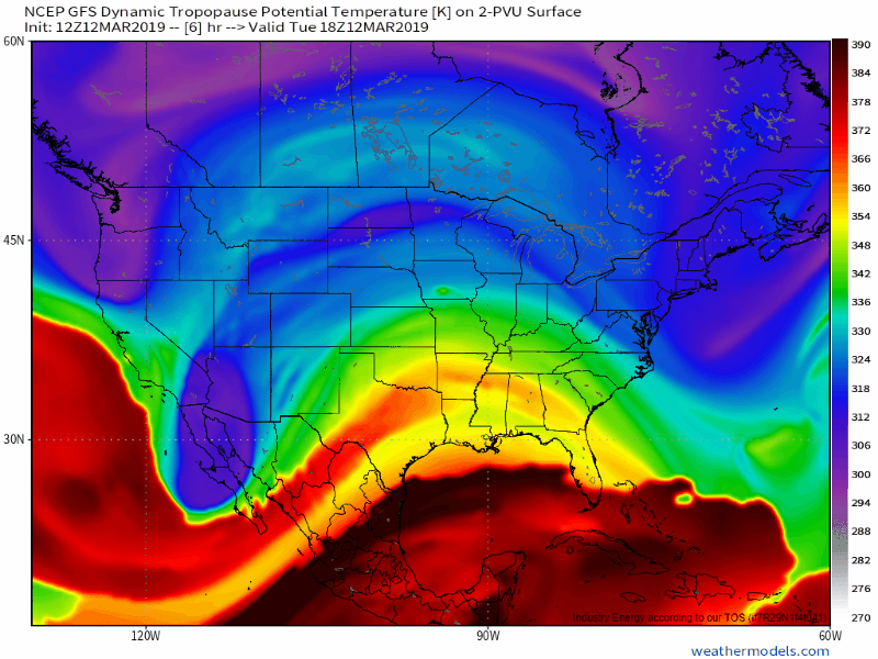
Instability is a function of the vertical gradient in temperature. We can see that the tropopause is far cooler than 2017! Never be deceived that modest SSTs precludes hyperactivity especially in the context of this years' CSU and NOAA forecasts
h/t to Alex Boreham
https://i.imgur.com/ujvkt5d.png https://i.imgur.com/i9R0WDd.png https://i.imgur.com/0WAqIaS.png
What would cause the Tpause to be cooler? Does that mean its higher up than normal, or is the whole atmosphere cooler?
Numerous forcing conditions can cause anomalous temperature changes, this includes natural and anthropogenic. To start, the second part of your question is a bit easier to answer. The height of the tropopause is usually dictated by a) location (more specifically, the latitude) and b) seasonal changes (winter/summer). You're absolutely correct that the temperature change results in the lowering (colder temperatures) or raising (warmer temperatures) of the tropopause. Below is an image of different heights given different locations/seasons:

The first part of your question is multifaceted, and can range from natural (solar radiation, cycles, oscillations, volcanic activity, etc.) or anthropogenic (greenhouse gas emissions), but I'll focus more on what usually drives anomalous temperature changes in the tropopause. The main driving force in the tropics is tied to ENSO and the quasi-biennial oscillation (QBO). Ocean temperatures in the Pacific dominates interannual variability/anomalies in the troposphere all the way up to the lowermost stratosphere. During an El Nino event, the tropical troposphere warms and pushes the tropopause (essentially the divergent/boundary line between the troposphere and stratosphere); during a La Nina event, the tropical troposphere cools which causes the tropopause to descend. In addition, ENSO alters some of the atmospheric circulation cells, such as the Walker and Hadley circulations. Below is an image of the tropopause and how difference oscillations/cells can alter the height:

How does this impact cyclones? It's mostly cyclogenesis that be enhanced by the gradient difference. We can see this in particular during winter storms (see animation and article below from Jack Sillin at Weather.us):
 https://blog.weather.us/dynamic-tropopause/
Also will point out that cyclones themselves can have a direct impact on the tropopause structure, mainly through latent heat release, but also through a process known as stratosphere–troposphere exchange (sparing the exact details, it relates to ozone and water vapor budget though). The main takeaway is a persistent (and normally strong system) can enhance the air mass exchange between the troposphere and stratosphere. Since these changes occur mostly at the tropopause where the boundary is, it can also alter the upper troposphere and lower stratosphere region. You can read more about those processes here -
https://d-nb.info/1141098229/34


