Texas Summer 2022

U.S. & Caribbean Weather Discussions and Severe Weather Events

Moderator: S2k Moderators

Forum rules

The posts in this forum are NOT official forecast and should not be used as such. They are just the opinion of the poster and may or may not be backed by sound meteorological data. They are NOT endorsed by any professional institution or STORM2K.

Help Support Storm2K
Message
Author
User avatar
Iceresistance
Category 5
Category 5
Posts: 9288
Age: 21
Joined: Sat Oct 10, 2020 9:45 am
Location: Tecumseh, OK/Norman, OK

Re: Texas Summer 2022

#561 Postby Iceresistance » Tue Jul 12, 2022 10:54 am

Brent wrote:
Ntxw wrote:
Brent wrote:
Yeah been all over the weather segments here today. Boy we're just hitting all the bad records aren't we :spam:


CPC centers heat over Oklahoma/NTX in the next round. ENs are doing a ridge flex sometime after the 20th.

https://i.imgur.com/BM8qR8l.png


Yeah tomorrow and Wednesday we may stay in the 90s but after that it looks like a long stretch over 100. The TWC app has it still going in 2 weeks :spam:

We only average 8 and I think today was 7


I've recently checked KFOR and the NWS-Norman Forecast for my area, and the temperatures have trended lower, it used to be 100s nonstop, but it's now near 100 for the long term for now.
0 likes   
Bill 2015 & Beta 2020

Winter 2020-2021 :cold:

All observations are in Tecumseh, OK unless otherwise noted.

Winter posts are focused mainly for Oklahoma & Texas.

Take any of my forecasts with a grain of salt, refer to the NWS, SPC, and NHC for official information

Never say Never with weather! Because ANYTHING is possible!

User avatar
cheezyWXguy
Category 5
Category 5
Posts: 6108
Joined: Mon Feb 13, 2006 12:29 am
Location: Dallas, TX

Re: Texas Summer 2022

#562 Postby cheezyWXguy » Tue Jul 12, 2022 12:06 pm

Uhhhh what kind of crack is the 12z gfs on?
0 likes   

User avatar
captainbarbossa19
Professional-Met
Professional-Met
Posts: 1092
Age: 27
Joined: Wed Aug 21, 2019 11:09 pm
Location: Beaumont, TX

Re: Texas Summer 2022

#563 Postby captainbarbossa19 » Tue Jul 12, 2022 12:20 pm

cheezyWXguy wrote:Uhhhh what kind of crack is the 12z gfs on?


The same warm-bias models have had long-range all summer. Nothing new. Temperatures will probably end up being 10-20 degrees cooler. :spam:
2 likes   

User avatar
captainbarbossa19
Professional-Met
Professional-Met
Posts: 1092
Age: 27
Joined: Wed Aug 21, 2019 11:09 pm
Location: Beaumont, TX

Re: Texas Summer 2022

#564 Postby captainbarbossa19 » Tue Jul 12, 2022 12:25 pm

DallasAg wrote:Today marks 25 consecutive days without any precip at DFW and 39 consecutive without measurable precip. 30 and 44 respectively get us to Top 10.

#1 was that horrible stretch in 2000 - 55 and 84 days. 111 on Labor Day that year. Yuck.


I think 2000 is the perfect analog for this year. 3rd year La Nina. 2001 was much better in every aspect. Bring on the new year.
1 likes   

User avatar
TropicalTundra
S2K Supporter
S2K Supporter
Posts: 703
Joined: Wed Oct 16, 2019 12:56 pm
Location: Temple, Texas

Re: Texas Summer 2022

#565 Postby TropicalTundra » Tue Jul 12, 2022 1:27 pm

cheezyWXguy wrote:Uhhhh what kind of crack is the 12z gfs on?


Nothing new. Easy to believe that 12z run won’t happen. Especially because the GFS isn’t showing double digit negatives during the winter
0 likes   
Summer's for hibernation, Winter’s my vacation

Don't use my posts as forecast, I'm a complete meteorology noob! I just like cold weather, alright?

All observations I post are for Temple, Texas unless otherwise stated.

User avatar
cheezyWXguy
Category 5
Category 5
Posts: 6108
Joined: Mon Feb 13, 2006 12:29 am
Location: Dallas, TX

Re: Texas Summer 2022

#566 Postby cheezyWXguy » Tue Jul 12, 2022 2:13 pm

TropicalTundra wrote:
cheezyWXguy wrote:Uhhhh what kind of crack is the 12z gfs on?


Nothing new. Easy to believe that 12z run won’t happen. Especially because the GFS isn’t showing double digit negatives during the winter

I mean, I can’t imagine anyone would take a 121 reading in dfw seriously 2 weeks out. A pattern like that could easily produce 110 degree temps though given the conditions and time of year, which parts of the state have already been dealing with. Main question is, does such an expansive high set up over this area at any point? It seems to me like a possibility
0 likes   

Brent
S2K Supporter
S2K Supporter
Posts: 38090
Age: 36
Joined: Sun May 16, 2004 10:30 pm
Location: Tulsa Oklahoma
Contact:

Re: Texas Summer 2022

#567 Postby Brent » Tue Jul 12, 2022 2:50 pm

cheezyWXguy wrote:
TropicalTundra wrote:
cheezyWXguy wrote:Uhhhh what kind of crack is the 12z gfs on?


Nothing new. Easy to believe that 12z run won’t happen. Especially because the GFS isn’t showing double digit negatives during the winter

I mean, I can’t imagine anyone would take a 121 reading in dfw seriously 2 weeks out. A pattern like that could easily produce 110 degree temps though given the conditions and time of year, which parts of the state have already been dealing with. Main question is, does such an expansive high set up over this area at any point? It seems to me like a possibility


Lol I quit looking at it tbh... It had a high of 120 here the other day. The all time high is 115 from the dust bowl. Even 2011 and 1980 didn't beat it :spam:

I mean I don't doubt it'll be hot and we might even get on the higher end of the temps this summer (105 I think is our highest right now). But yeah I've noticed the long range has been too hot for awhile now
0 likes   
#neversummer

cstrunk
Category 2
Category 2
Posts: 635
Joined: Sat Jul 04, 2020 10:38 am
Location: Longview, TX

Re: Texas Summer 2022

#568 Postby cstrunk » Tue Jul 12, 2022 4:26 pm

There are at least a few areas getting some isolated showers and that should continue for the next couple of days. May the odds be ever in your favor.
1 likes   

User avatar
Ntxw
Storm2k Moderator
Storm2k Moderator
Posts: 22785
Joined: Wed Oct 21, 2009 6:34 pm
Location: DFW, Texas

Re: Texas Summer 2022

#569 Postby Ntxw » Tue Jul 12, 2022 4:28 pm

Euro 850s would be ripe for a 108-111F+ type reading in Oklahoma and North Texas. Austin and the middle-southern part of the state has been achieving with cooler 850s.

Do agree 120s on GFSlalaland is too extreme and quite unlikely, that's all time state records.
0 likes   
The above post and any post by Ntxw is NOT an official forecast and should not be used as such. It is just the opinion of the poster and may or may not be backed by sound meteorological data. It is NOT endorsed by any professional institution including Storm2k. For official information, please refer to NWS products.

  Help support Storm2K!
Help Support Storm2K

User avatar
SoupBone
Category 5
Category 5
Posts: 3111
Joined: Tue Sep 20, 2005 5:24 pm

Re: Texas Summer 2022

#570 Postby SoupBone » Tue Jul 12, 2022 5:28 pm

Got about 3 minutes of rain in Cypress today. I guess it's better than nothing.
1 likes   
Personal Forecast Disclaimer:
The posts in this forum are NOT official forecast and should not be used as such. They are just the opinion of the poster and may or may not be backed by sound meteorological data. They are NOT endorsed by any professional institution or storm2k.org. For official information, please refer to the NHC and NWS products.

Yukon Cornelius
S2K Supporter
S2K Supporter
Posts: 1798
Age: 41
Joined: Thu Dec 20, 2012 9:23 pm
Location: Dean, TX/Westcliffe, CO

Re: Texas Summer 2022

#571 Postby Yukon Cornelius » Tue Jul 12, 2022 8:26 pm

28th day of over 100 in WF with no end in sight..
0 likes   
#neversummer

weatherdude1108
Category 5
Category 5
Posts: 4228
Joined: Tue Dec 13, 2011 1:04 pm
Location: Northwest Austin/Cedar Park, TX

Re: Texas Summer 2022

#572 Postby weatherdude1108 » Tue Jul 12, 2022 9:04 pm

Yukon Cornelius wrote:28th day of over 100 in WF with no end in sight..


So sorry Yukon. :wink: You're about even with Austin. Something's gunna happen. It's gunna rain! I can feel it. Seriously though, there are Flood Advisories to my northwest near Mason and Brady into the Kerrville area.

Proof it CAN and DOES happen! :wink: Trying for some kind of "silver lining" in this lethal unrelenting, merciless pattern.
1 likes   
The preceding post is NOT an official forecast, and should not be used as such. It is only the opinion of the poster and may or may not be backed by sound meteorological data. It is NOT endorsed by any professional institution including storm2k.org. For Official Information please refer to the NHC and NWS products.

Nederlander
S2K Supporter
S2K Supporter
Posts: 1250
Joined: Sat Jul 19, 2008 4:28 pm
Location: Conroe, TX

Re: Texas Summer 2022

#573 Postby Nederlander » Tue Jul 12, 2022 11:52 pm

SoupBone wrote:Got about 3 minutes of rain in Cypress today. I guess it's better than nothing.

Better than here. 2nd day in a row I missed a nice cell by about 2 miles. Third or fourth time it’s happened in a week.
0 likes   

weatherdude1108
Category 5
Category 5
Posts: 4228
Joined: Tue Dec 13, 2011 1:04 pm
Location: Northwest Austin/Cedar Park, TX

Re: Texas Summer 2022

#574 Postby weatherdude1108 » Wed Jul 13, 2022 9:56 am

I have a general question related to the current weather pattern.

What exactly is causing this intense, relentless heat that we have been experiencing, that just doesn't seem to end, as compared to normal heat?

I'm looking at the map, and I see high pressure over New Mexico and the four corners area. My area is on the southeastern edge of the high pressure. There is low pressure over the Gulf and Louisiana to my east causing lots of rain there.

Is it the subsidence to the left of the low (where we are) that is exacerbating the.feedback loop?

I'm guessing what would be more ideal for rain would be high pressure on both sides of us, with us sandwiched in between in a low? I know something similar happened in 2007 where a low came out of Oklahoma in late May, and it parked over Texas most of that Summer, creating one of the wettest Junes.

Now, we have a boundary initiating pop up storms in some cases right now. I m assuming that is because of our position (SE side of ridge) to the forming boundaries on SE side of ridge? But it's not enough to lower the temps below "blast furnace" levels.

Just really trying to understand and analyze this heat wave, for my own education.

None of the weather people on TV that I have seen mention the mechanics on WHY it is the way it is. They just.say stuff like "High means dry, baking,", etc.

Might need the perspective of a pro met(?). This is why I love this forum! I feel like we have better weather forecasters and explainers than what you can find on TV. Thanks for any feedback! :)
0 likes   
The preceding post is NOT an official forecast, and should not be used as such. It is only the opinion of the poster and may or may not be backed by sound meteorological data. It is NOT endorsed by any professional institution including storm2k.org. For Official Information please refer to the NHC and NWS products.

User avatar
Ntxw
Storm2k Moderator
Storm2k Moderator
Posts: 22785
Joined: Wed Oct 21, 2009 6:34 pm
Location: DFW, Texas

Re: Texas Summer 2022

#575 Postby Ntxw » Wed Jul 13, 2022 10:16 am

weatherdude1108 wrote:I have a general question related to the current weather pattern.

What exactly is causing this intense, relentless heat that we have been experiencing, that just doesn't seem to end, as compared to normal heat?


This is an extremely loaded question! Some anecdotal.

This is not something that just suddenly popped up. The seeds were planted many months ago, arguably back to last Fall.

General rule is La Nina favors warmth and drought in Texas, but not always there are good and bad La Ninas. 2020 and 2021 were 'good' La Ninas. Despite them being so they had tendencies of weather patterns that gave us rain, remnants of a Pacific-Like Nino patterns. MJO at times were in Nino phases despite the burgeoning Ninas. From September to October of 2021 the Pacific changed. -PDO deepened and a couple of weeks of dry-ness became months of dry-ness through Spring. SOI became more and more negative. Then you had December, thanks to the Pacific pattern.

Forward to Spring, the rains were going to come because it's Spring! However it too was lackluster. Normal rains came as the PVa anomalies were shifting north with the natural seasonal warmth and it moved further north as the time went. During the season we lacked mid and upper moisture from the Pacific, cloud cover and moisture above can help cool the lower layer of the atmosphere but this wasn't occurring despite it raining in X-county over NTX or Oklahoma etc. Unabated warming above us set the stage for the ground drought and atmospheric drought to couple.

But in the background the PDO nose-dived and the SOI went with it to a historic stretch of negatives. What they were telling us that the Nina and the rest of the Pacific was going to couple, both tropics and mid latitudes. You can fight it with one or the other but losing both was a double whammy. And here we are in the dry season. That lack of Pacific help magnified. The heat-drought has already coupled with nothing to disturb it so it's a runaway feedback loop. When the ridge is weak the drought-fed warmth keeps the temps elevated, nothing is streaming from the Pacific to disturb it. When it flexes it takes that elevated heat and takes it a step further. It will stay that way until something knocks it off, and the Pacific is continuing to tell us with the SOI not coming from that direction.
7 likes   
The above post and any post by Ntxw is NOT an official forecast and should not be used as such. It is just the opinion of the poster and may or may not be backed by sound meteorological data. It is NOT endorsed by any professional institution including Storm2k. For official information, please refer to NWS products.


  Help support Storm2K!

Help Support Storm2K


cstrunk
Category 2
Category 2
Posts: 635
Joined: Sat Jul 04, 2020 10:38 am
Location: Longview, TX

Re: Texas Summer 2022

#576 Postby cstrunk » Wed Jul 13, 2022 11:41 am

A marginal risk for severe weather has been added today for much of East Texas for damaging wind potential from this afternoon's mostly isolated storms.
0 likes   

User avatar
cheezyWXguy
Category 5
Category 5
Posts: 6108
Joined: Mon Feb 13, 2006 12:29 am
Location: Dallas, TX

Re: Texas Summer 2022

#577 Postby cheezyWXguy » Wed Jul 13, 2022 11:49 am

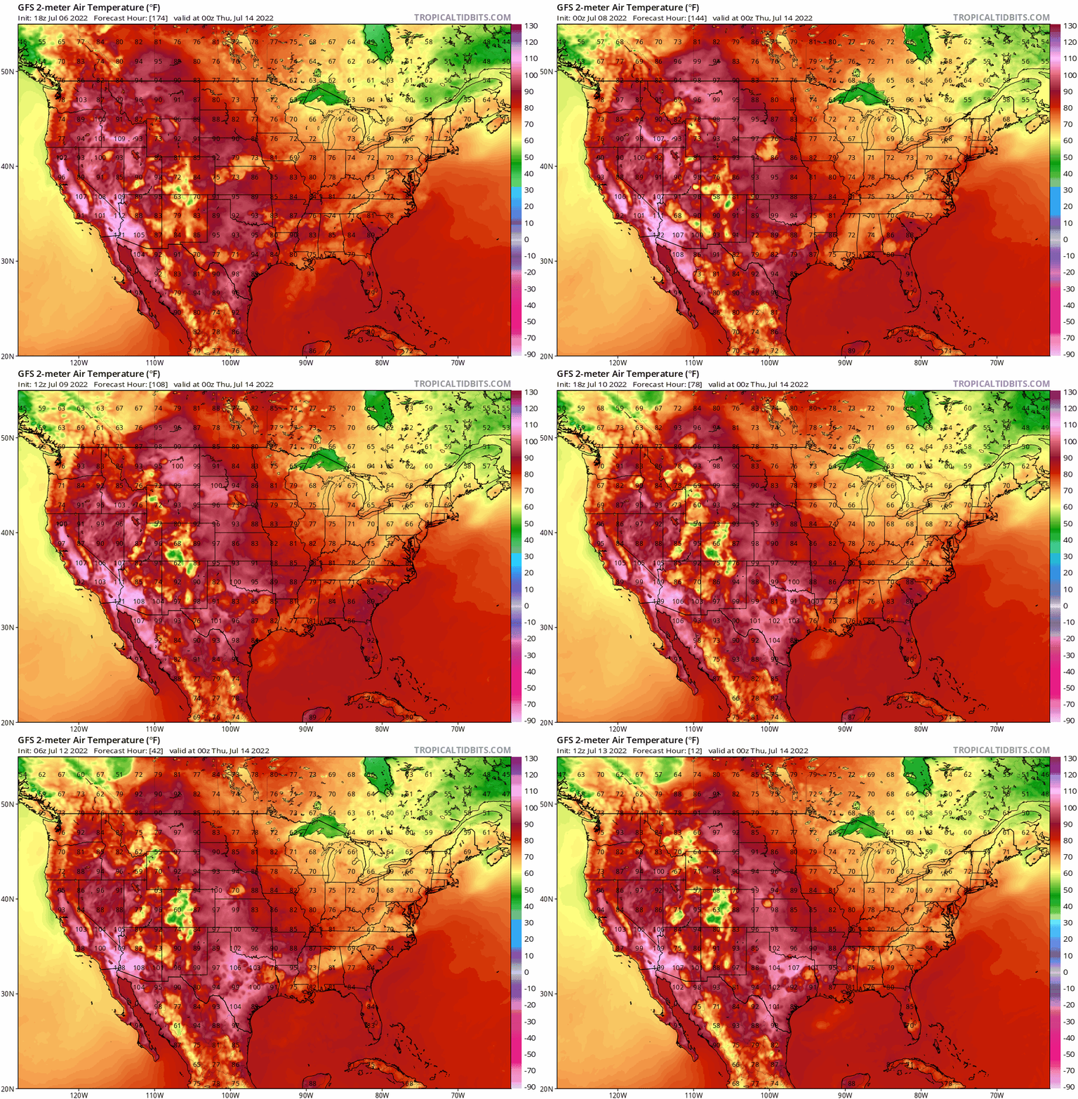
In regard to the crazy temps the gfs has been showing in the long range - if such temps were projected within 7-8 days, I might start taking them a bit more seriously. I’ve started looking at gfs projected 0z temps for the day of, then filing back through previous runs for the same time/date to see how they’ve trended, and within about 180 hours it doesn’t seem too far off (outside of depicted precip reducing temps).
This is the trend gif for 0z today
Image

That said, no mind boggling temps showing up in that range at this point.
1 likes   

User avatar
Ntxw
Storm2k Moderator
Storm2k Moderator
Posts: 22785
Joined: Wed Oct 21, 2009 6:34 pm
Location: DFW, Texas

Re: Texas Summer 2022

#578 Postby Ntxw » Wed Jul 13, 2022 12:49 pm

Ercot reserves are below 3k MW with lower output today. They're asking again for conservation just now. Seems like dicey waters this afternoon.
0 likes   
The above post and any post by Ntxw is NOT an official forecast and should not be used as such. It is just the opinion of the poster and may or may not be backed by sound meteorological data. It is NOT endorsed by any professional institution including Storm2k. For official information, please refer to NWS products.


  Help support Storm2K!

Help Support Storm2K


User avatar
jasons2k
Storm2k Executive
Storm2k Executive
Posts: 8245
Age: 51
Joined: Wed Jul 06, 2005 12:32 pm
Location: The Woodlands, TX

Re: Texas Summer 2022

#579 Postby jasons2k » Wed Jul 13, 2022 1:01 pm

After 6 weeks with no rain (since June 1st) I finally received a generous .89" yesterday. It has made a world of difference already with the vegetation. Now if only if we could keep it going for awhile...
2 likes   

User avatar
Ntxw
Storm2k Moderator
Storm2k Moderator
Posts: 22785
Joined: Wed Oct 21, 2009 6:34 pm
Location: DFW, Texas

Re: Texas Summer 2022

#580 Postby Ntxw » Wed Jul 13, 2022 3:28 pm

0 likes   
The above post and any post by Ntxw is NOT an official forecast and should not be used as such. It is just the opinion of the poster and may or may not be backed by sound meteorological data. It is NOT endorsed by any professional institution including Storm2k. For official information, please refer to NWS products.


  Help support Storm2K!

Help Support Storm2K


Return to “USA & Caribbean Weather”

Who is online

Users browsing this forum: No registered users and 22 guests