EPAC: DARBY - Remnants
Moderator: S2k Moderators
-
Sciencerocks
- Category 5

- Posts: 10193
- Age: 40
- Joined: Thu Jul 06, 2017 1:51 am


Re: EPAC: DARBY - Hurricane
It's managed to surpass Bonnie in ACE. Perhaps enough life left to make 17+ units.
1 likes
The above post and any post by Ntxw is NOT an official forecast and should not be used as such. It is just the opinion of the poster and may or may not be backed by sound meteorological data. It is NOT endorsed by any professional institution including Storm2k. For official information, please refer to NWS products.
Help support Storm2K!

-
cycloneye

- Admin

- Posts: 149730
- Age: 69
- Joined: Thu Oct 10, 2002 10:54 am
- Location: San Juan, Puerto Rico
Re: EPAC: DARBY - Hurricane
EP, 05, 2022071500, , BEST, 0, 174N, 1427W, 80, 983, HU
0 likes
Visit the Caribbean-Central America Weather Thread where you can find at first post web cams,radars
and observations from Caribbean basin members Click Here
and observations from Caribbean basin members Click Here
-
Sciencerocks
- Category 5
- Posts: 10193
- Age: 40
- Joined: Thu Jul 06, 2017 1:51 am
-
Yellow Evan

- Professional-Met

- Posts: 16257
- Age: 27
- Joined: Fri Jul 15, 2011 12:48 pm
- Location: Henderson, Nevada/Honolulu, HI
- Contact:
Re: EPAC: DARBY - Tropical Storm
Finally getting exposed. I'd expect full PTC by Saturday afternoon.
0 likes
-
weeniepatrol

- Category 5
- Posts: 1345
- Joined: Sat Aug 22, 2020 5:30 pm
- Location: WA State
Re: EPAC: DARBY - Tropical Storm
Yellow Evan wrote:Finally getting exposed. I'd expect full PTC by Saturday afternoon.
I always read this as Potential Tropical Cyclone
3 likes
-
Astromanía
- Category 2

- Posts: 798
- Age: 27
- Joined: Sat Aug 25, 2018 10:34 pm
- Location: Monterrey, N.L, México
Re: EPAC: DARBY - Tropical Storm
weeniepatrol wrote:Yellow Evan wrote:Finally getting exposed. I'd expect full PTC by Saturday afternoon.
I always read this as Potential Tropical Cyclone
Me too hahaha
0 likes
-
Yellow Evan
- Professional-Met
- Posts: 16257
- Age: 27
- Joined: Fri Jul 15, 2011 12:48 pm
- Location: Henderson, Nevada/Honolulu, HI
- Contact:
-
Yellow Evan
- Professional-Met
- Posts: 16257
- Age: 27
- Joined: Fri Jul 15, 2011 12:48 pm
- Location: Henderson, Nevada/Honolulu, HI
- Contact:
Re: EPAC: DARBY - Tropical Storm
TXPN23 KNES 151815
TCSCNP
A. 05E (DARBY)
B. 15/1731Z
C. 17.5N
D. 146.7W
E. THREE/GOES-W
F. T2.0/3.0
G. IR/EIR/VIS
H. REMARKS...THIS SYSTEM IS TOO WEAK TO CLASSIFY DUE TO SUDDEN LOSS
OF CONVECTION. MET IS 3.0 BASED ON RAPID WEAKENING TREND OVER LAST 24
HOURS. PT IS 2.5. FT IS BASED ON CONSTRAINTS THAT PREVENT THE CHANGE OF
FT 1 OVER 6 HOURS.
I. ADDL POSITIONS
NIL
...NGUYEN
0 likes
-
TallyTracker
- Category 2
- Posts: 787
- Joined: Thu Oct 11, 2018 2:46 pm
Re: EPAC: DARBY - Tropical Storm
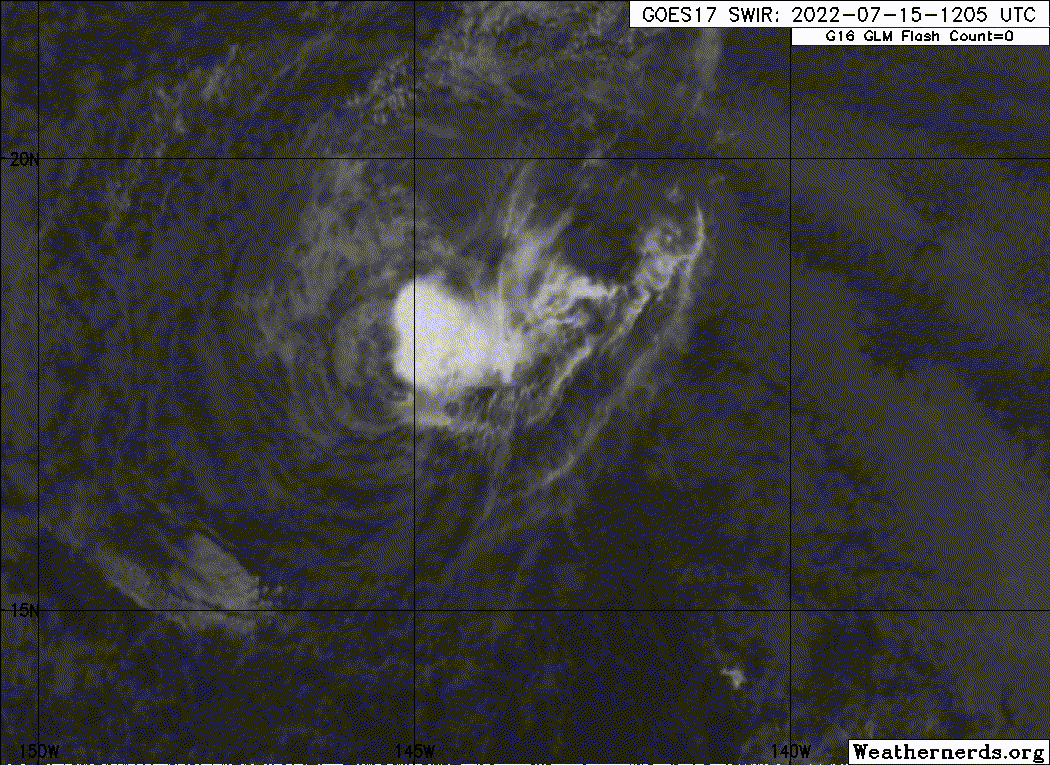
Darby already looks like a remnant low. Albeit one with strong TS winds yet. Good chance it will be post-tropical within 12 hours assuming a lone thunderstorm cell doesn’t prolong the decay.
0 likes
Fran '96, Georges '98, Gordon '00, Gabrielle '01, Charley '04, Frances '04, Jeanne '04, Barry '07, Fay '08, Debby '12, Matthew '16, Emily '17, Irma '17, Michael ‘18, Elsa ‘21, Fred ‘21, Mindy ‘21, Nicole ‘22, Idalia ‘23, Debby ‘24, Helene ‘24
-
wxman57

- Moderator-Pro Met

- Posts: 23175
- Age: 68
- Joined: Sat Jun 21, 2003 8:06 pm
- Location: Houston, TX (southwest)
Re: EPAC: DARBY - Tropical Storm
I agree that Darby looks like a remnant low now. NHC saying a "conservative" 50 kts, but all Dvorak numbers are 2.0 or lower. ASCAT-B hit it at 1915Z. Has one 35kt barb on NW side, otherwise 20-30 kts. Probably weaker now. I have to do it...

1 likes

Re: EPAC: DARBY - Tropical Storm
It’s so strange how the NHC has pulled the plug on systems that were still generating a bit of convection, but they’re calling Darby’s naked swirl a 60 mph TS.
0 likes
Irene '11 Sandy '12 Hermine '16 5/15/2018 Derecho Fay '20 Isaias '20 Elsa '21 Henri '21 Ida '21
I am only a meteorology enthusiast who knows a decent amount about tropical cyclones. Look to the professional mets, the NHC, or your local weather office for the best information.
I am only a meteorology enthusiast who knows a decent amount about tropical cyclones. Look to the professional mets, the NHC, or your local weather office for the best information.
-
Yellow Evan
- Professional-Met
- Posts: 16257
- Age: 27
- Joined: Fri Jul 15, 2011 12:48 pm
- Location: Henderson, Nevada/Honolulu, HI
- Contact:
Re: EPAC: DARBY - Tropical Storm
Darby hasn’t been declared a post tropical remnant low yet because it hasn’t been devoid of deep convection for 12 hours. The reason that criteria is in place is in case deep convection re-develops. Post-season the NHC generally pushes post-tropical status up 12 hours if deep convection fails to redevelop.
3 likes
-
Yellow Evan
- Professional-Met
- Posts: 16257
- Age: 27
- Joined: Fri Jul 15, 2011 12:48 pm
- Location: Henderson, Nevada/Honolulu, HI
- Contact:
Re: EPAC: DARBY - Tropical Storm
TXPN23 KNES 152356
TCSCNP
A. 05E (DARBY)
B. 15/2330Z
C. 17.5N
D. 148.3W
E. THREE/GOES-W
F. SUBTROPICAL
G. IR/EIR/VIS
H. REMARKS...THIS WILL BE THE FINAL BULLETIN UNLESS SATELLITE ANALYSIS
SUGGESTS THE SYSTEM HAS BECOME PURELY TROPICAL IN NATURE.
I. ADDL POSITIONS
NIL
...FISHER
TCSCNP
A. 05E (DARBY)
B. 15/2330Z
C. 17.5N
D. 148.3W
E. THREE/GOES-W
F. SUBTROPICAL
G. IR/EIR/VIS
H. REMARKS...THIS WILL BE THE FINAL BULLETIN UNLESS SATELLITE ANALYSIS
SUGGESTS THE SYSTEM HAS BECOME PURELY TROPICAL IN NATURE.
I. ADDL POSITIONS
NIL
...FISHER
???
4 likes
-
cycloneye
- Admin
- Posts: 149730
- Age: 69
- Joined: Thu Oct 10, 2002 10:54 am
- Location: San Juan, Puerto Rico
Re: EPAC: DARBY - Tropical Storm
Yellow Evan wrote:TXPN23 KNES 152356
TCSCNP
A. 05E (DARBY)
B. 15/2330Z
C. 17.5N
D. 148.3W
E. THREE/GOES-W
F. SUBTROPICAL
G. IR/EIR/VIS
H. REMARKS...THIS WILL BE THE FINAL BULLETIN UNLESS SATELLITE ANALYSIS
SUGGESTS THE SYSTEM HAS BECOME PURELY TROPICAL IN NATURE.
I. ADDL POSITIONS
NIL
...FISHER
???
Why is subtropical?
0 likes
Visit the Caribbean-Central America Weather Thread where you can find at first post web cams,radars
and observations from Caribbean basin members Click Here
and observations from Caribbean basin members Click Here
-
ElectricStorm

- Category 5
- Posts: 5156
- Age: 25
- Joined: Tue Aug 13, 2019 11:23 pm
- Location: Norman, OK
Re: EPAC: DARBY - Tropical Storm
05E DARBY 220716 0000 17.7N 148.5W EPAC 40 1006
0 likes
B.S Meteorology, University of Oklahoma '25
Please refer to the NHC, NWS, or SPC for official information.
Please refer to the NHC, NWS, or SPC for official information.
-
weeniepatrol
- Category 5
- Posts: 1345
- Joined: Sat Aug 22, 2020 5:30 pm
- Location: WA State
Re: EPAC: DARBY - Tropical Storm
Yellow Evan wrote:TXPN23 KNES 152356
TCSCNP
A. 05E (DARBY)
B. 15/2330Z
C. 17.5N
D. 148.3W
E. THREE/GOES-W
F. SUBTROPICAL
G. IR/EIR/VIS
H. REMARKS...THIS WILL BE THE FINAL BULLETIN UNLESS SATELLITE ANALYSIS
SUGGESTS THE SYSTEM HAS BECOME PURELY TROPICAL IN NATURE.
I. ADDL POSITIONS
NIL
...FISHER
???
Welp this fix is an instant hall of famer
4 likes
-
cycloneye
- Admin
- Posts: 149730
- Age: 69
- Joined: Thu Oct 10, 2002 10:54 am
- Location: San Juan, Puerto Rico
Re: EPAC: DARBY - Tropical Storm
Still a TS.
EP, 05, 2022071612, , BEST, 0, 175N, 1524W, 40, 1006, TS
0 likes
Visit the Caribbean-Central America Weather Thread where you can find at first post web cams,radars
and observations from Caribbean basin members Click Here
and observations from Caribbean basin members Click Here
-
Astromanía
- Category 2
- Posts: 798
- Age: 27
- Joined: Sat Aug 25, 2018 10:34 pm
- Location: Monterrey, N.L, México

Re: EPAC: DARBY - Tropical Storm
Rain shield approaching main island.
0 likes
Personal Forecast Disclaimer:
The posts in this forum are NOT official forecast and should not be used as such. They are just the opinion of the poster and may or may not be backed by sound meteorological data. For official information, please refer to the NHC and NWS products.
The posts in this forum are NOT official forecast and should not be used as such. They are just the opinion of the poster and may or may not be backed by sound meteorological data. For official information, please refer to the NHC and NWS products.
Who is online
Users browsing this forum: No registered users and 34 guests