EPAC: ESTELLE - Post-Tropical
Moderator: S2k Moderators
-
InfernoFlameCat

- Category 5

- Posts: 2127
- Age: 23
- Joined: Mon Dec 14, 2020 10:52 am
- Location: Buford, GA
Re: EPAC: ESTELLE - Hurricane
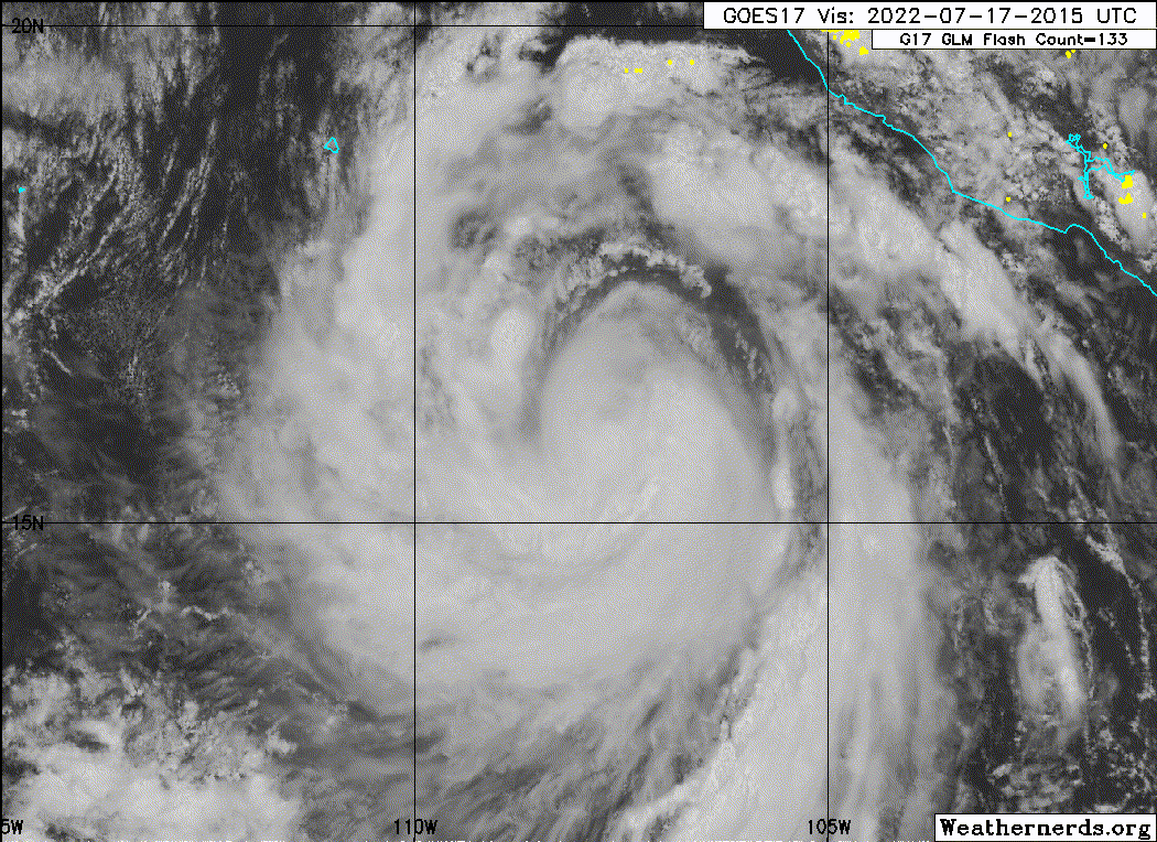
Mid level shear is messing this thing up.
0 likes
I am by no means a professional. DO NOT look at my forecasts for official information or make decisions based on what I post.
Goal: to become a registered expert over tropical and subtropical cyclones.
Goal: to become a registered expert over tropical and subtropical cyclones.

Re: EPAC: ESTELLE - Hurricane
InfernoFlameCat wrote:Mid level shear is messing this thing up.
Also banding. That one large band on Estelle’s west side is probably competing with the core.
0 likes
Irene '11 Sandy '12 Hermine '16 5/15/2018 Derecho Fay '20 Isaias '20 Elsa '21 Henri '21 Ida '21
I am only a meteorology enthusiast who knows a decent amount about tropical cyclones. Look to the professional mets, the NHC, or your local weather office for the best information.
I am only a meteorology enthusiast who knows a decent amount about tropical cyclones. Look to the professional mets, the NHC, or your local weather office for the best information.
-
skyline385

- Category 5
- Posts: 2728
- Age: 35
- Joined: Wed Aug 26, 2020 11:15 pm
- Location: Houston TX
EPAC: ESTELLE - Hurricane
Still struggling with the shear, everytime it tries to build up convection on the N-NE side it immediately dissipates

0 likes
-
Yellow Evan

- Professional-Met

- Posts: 16257
- Age: 27
- Joined: Fri Jul 15, 2011 12:48 pm
- Location: Henderson, Nevada/Honolulu, HI
- Contact:
Re: EPAC: ESTELLE - Hurricane
TXPZ27 KNES 171755
TCSENP
A. 06E (ESTELLE)
B. 17/1730Z
C. 15.8N
D. 107.3W
E. THREE/GOES-E
F. T4.0/4.0
G. IR/EIR/VIS
H. REMARKS...SYSTEM CHARACTERIZED BY A LLCC EMBEDDED IN LG FOR A DT=4.5
MET=4.5 PT=4.0. FT IS BASED ON PT DUE TO LOW CONFIDENCE THE LLCC POSITION.
I. ADDL POSITIONS
NIL
...FISHER
TCSENP
A. 06E (ESTELLE)
B. 17/1730Z
C. 15.8N
D. 107.3W
E. THREE/GOES-E
F. T4.0/4.0
G. IR/EIR/VIS
H. REMARKS...SYSTEM CHARACTERIZED BY A LLCC EMBEDDED IN LG FOR A DT=4.5
MET=4.5 PT=4.0. FT IS BASED ON PT DUE TO LOW CONFIDENCE THE LLCC POSITION.
I. ADDL POSITIONS
NIL
...FISHER
0 likes
-
Kingarabian

- S2K Supporter

- Posts: 16379
- Joined: Sat Aug 08, 2009 3:06 am
- Location: Honolulu, Hawaii
-
cycloneye

- Admin

- Posts: 149730
- Age: 69
- Joined: Thu Oct 10, 2002 10:54 am
- Location: San Juan, Puerto Rico
Re: EPAC: ESTELLE - Hurricane
EP, 06, 2022071718, , BEST, 0, 159N, 1074W, 75, 984, HU
0 likes
Visit the Caribbean-Central America Weather Thread where you can find at first post web cams,radars
and observations from Caribbean basin members Click Here
and observations from Caribbean basin members Click Here
Re: EPAC: ESTELLE - Hurricane
Yeah no way this is becoming a major. It doesn’t have a great structure and shear is just strong enough to prevent it from improving.
0 likes
Irene '11 Sandy '12 Hermine '16 5/15/2018 Derecho Fay '20 Isaias '20 Elsa '21 Henri '21 Ida '21
I am only a meteorology enthusiast who knows a decent amount about tropical cyclones. Look to the professional mets, the NHC, or your local weather office for the best information.
I am only a meteorology enthusiast who knows a decent amount about tropical cyclones. Look to the professional mets, the NHC, or your local weather office for the best information.
-
InfernoFlameCat
- Category 5
- Posts: 2127
- Age: 23
- Joined: Mon Dec 14, 2020 10:52 am
- Location: Buford, GA
Re: EPAC: ESTELLE - Hurricane
Dry air and mid level shear are wrecking havoc upon the storms structure. It can’t close off.
0 likes
I am by no means a professional. DO NOT look at my forecasts for official information or make decisions based on what I post.
Goal: to become a registered expert over tropical and subtropical cyclones.
Goal: to become a registered expert over tropical and subtropical cyclones.
-
ElectricStorm

- Category 5
- Posts: 5156
- Age: 25
- Joined: Tue Aug 13, 2019 11:23 pm
- Location: Norman, OK
Re: EPAC: ESTELLE - Hurricane
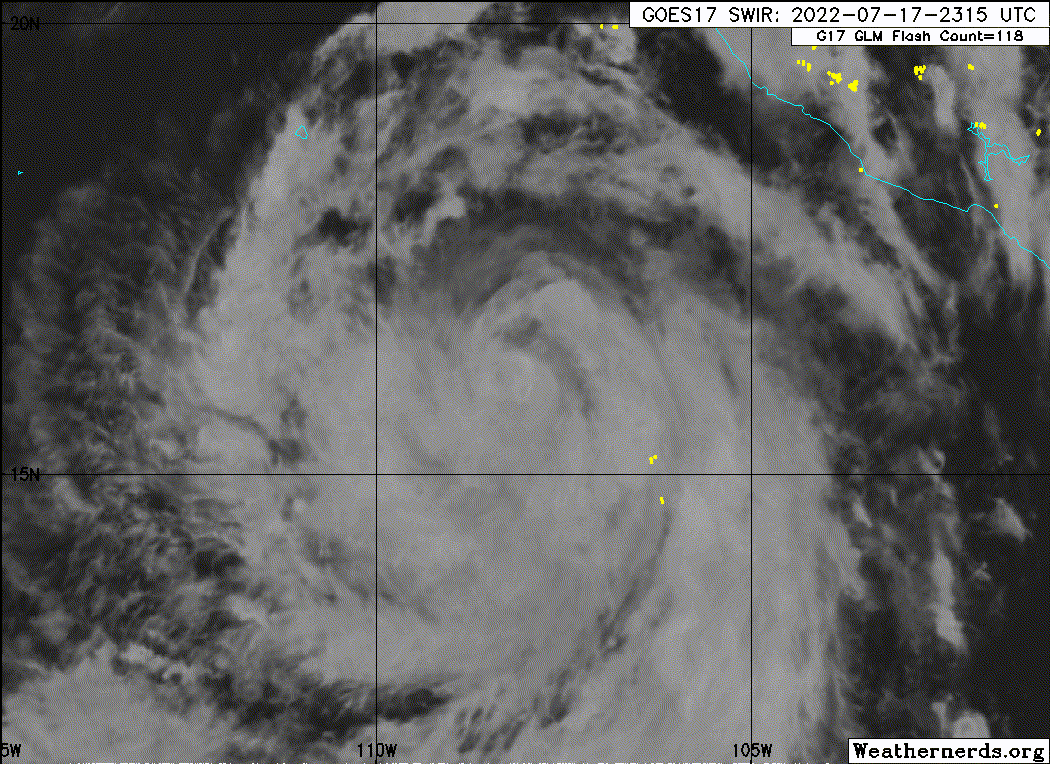
Yeah this isn't looking good at all right now. Wouldn't be surprised if it's less than 75kts now honestly
0 likes
B.S Meteorology, University of Oklahoma '25
Please refer to the NHC, NWS, or SPC for official information.
Please refer to the NHC, NWS, or SPC for official information.
-
cycloneye
- Admin
- Posts: 149730
- Age: 69
- Joined: Thu Oct 10, 2002 10:54 am
- Location: San Juan, Puerto Rico
Re: EPAC: ESTELLE - Hurricane
No longer forecast to be major cane.
0 likes
Visit the Caribbean-Central America Weather Thread where you can find at first post web cams,radars
and observations from Caribbean basin members Click Here
and observations from Caribbean basin members Click Here
-
Category5Kaiju

- Category 5
- Posts: 4347
- Joined: Thu Dec 24, 2020 12:45 pm
- Location: Seattle during the summer, Phoenix during the winter
Re: EPAC: ESTELLE - Hurricane
EPAC: "I want to defy logic and produce major hurricanes left and right in July of a third year La Nina! Here comes Estelle"
La Nina-based shear and dry air: "Yeah, sorry, not happening, Darby was enough. "
"
La Nina-based shear and dry air: "Yeah, sorry, not happening, Darby was enough.
3 likes
Unless explicitly stated, all information in my posts is based on my own opinions and observations. Tropical storms and hurricanes can be extremely dangerous. Refer to an accredited weather research agency or meteorologist if you need to make serious decisions regarding an approaching storm.
-
Yellow Evan
- Professional-Met
- Posts: 16257
- Age: 27
- Joined: Fri Jul 15, 2011 12:48 pm
- Location: Henderson, Nevada/Honolulu, HI
- Contact:
-
Sciencerocks
- Category 5
- Posts: 10193
- Age: 40
- Joined: Thu Jul 06, 2017 1:51 am
-
cycloneye
- Admin
- Posts: 149730
- Age: 69
- Joined: Thu Oct 10, 2002 10:54 am
- Location: San Juan, Puerto Rico
Re: EPAC: ESTELLE - Hurricane
Well, going down.
EP, 06, 2022071800, , BEST, 0, 165N, 1081W, 70, 986, HU
0 likes
Visit the Caribbean-Central America Weather Thread where you can find at first post web cams,radars
and observations from Caribbean basin members Click Here
and observations from Caribbean basin members Click Here
-
Sciencerocks
- Category 5
- Posts: 10193
- Age: 40
- Joined: Thu Jul 06, 2017 1:51 am
-
ElectricStorm
- Category 5
- Posts: 5156
- Age: 25
- Joined: Tue Aug 13, 2019 11:23 pm
- Location: Norman, OK
Re: EPAC: ESTELLE - Hurricane
Still forecast to hit Cat 2 but I think it missed it's opportunity to really get going. Dry air and shear are still disrupting it pretty good, and it may not even be able to intensify much again. Today was the day to do something and it wasn't able to get it done...
0 likes
B.S Meteorology, University of Oklahoma '25
Please refer to the NHC, NWS, or SPC for official information.
Please refer to the NHC, NWS, or SPC for official information.
-
InfernoFlameCat
- Category 5
- Posts: 2127
- Age: 23
- Joined: Mon Dec 14, 2020 10:52 am
- Location: Buford, GA
Re: EPAC: ESTELLE - Hurricane
Storm is a mess. ughh missed opportunity for some eye candy.
0 likes
I am by no means a professional. DO NOT look at my forecasts for official information or make decisions based on what I post.
Goal: to become a registered expert over tropical and subtropical cyclones.
Goal: to become a registered expert over tropical and subtropical cyclones.
-
Yellow Evan
- Professional-Met
- Posts: 16257
- Age: 27
- Joined: Fri Jul 15, 2011 12:48 pm
- Location: Henderson, Nevada/Honolulu, HI
- Contact:
Re: EPAC: ESTELLE - Hurricane
This had a really high ceiling with that upper level outflow pattern with dual outflow channels and great moisture envelope. But wind shear got in the way…
0 likes
-
Sciencerocks
- Category 5
- Posts: 10193
- Age: 40
- Joined: Thu Jul 06, 2017 1:51 am

-
tolakram
- Admin
- Posts: 20186
- Age: 62
- Joined: Sun Aug 27, 2006 8:23 pm
- Location: Florence, KY (name is Mark)
Re: EPAC: ESTELLE - Hurricane
Yellow Evan wrote:TXPZ27 KNES 171211
TCSENP
A. 06E (ESTELLE)
B. 17/1130Z
C. 15.5N
D. 106.6W
E. THREE/GOES-E
F. T3.5/4.0
G. IR/EIR/SWIR
H. REMARKS...SYSTEM CHARACTERIZED BY 10/10 BANDING ON A LOG-10
SCALE. DT=3.5 MET=4.5 PT=4.0 FT IS BASED ON DT.
I. ADDL POSITIONS
NIL
...FISHER
JTWC tier Dvoraking.
Can you explain your disagreement rather than just dropping a one line insult?
0 likes
M a r k
- - - - -
Join us in chat: Storm2K Chatroom Invite. Android and IOS apps also available.
The posts in this forum are NOT official forecasts and should not be used as such. Posts are NOT endorsed by any professional institution or STORM2K.org. For official information and forecasts, please refer to NHC and NWS products.
Who is online
Users browsing this forum: No registered users and 31 guests