2022 Indicators (SSTs/SAL/MSLP/Shear/Steering/Instability) and >Day 16 Models

This is the general tropical discussion area. Anyone can take their shot at predicting a storms path.

Moderator: S2k Moderators

Forum rules

The posts in this forum are NOT official forecasts and should not be used as such. They are just the opinion of the poster and may or may not be backed by sound meteorological data. They are NOT endorsed by any professional institution or STORM2K. For official information, please refer to products from the National Hurricane Center and National Weather Service.

Help Support Storm2K
Message
Author
User avatar
skyline385
Category 5
Category 5
Posts: 2728
Age: 34
Joined: Wed Aug 26, 2020 11:15 pm
Location: Houston TX

Re: 2022 Indicators (SSTs/SAL/MSLP/Shear/Steering/Instability) and >Day 16 Models

#1841 Postby skyline385 » Sun Jul 17, 2022 9:24 pm

cycloneye wrote:I always like the Tyler discussions and that is why I bring this twit.

https://twitter.com/TylerJStanfield/status/1548849483294949376


Been looking at 1988 recently too, not only because of the strong Nina strengthening during peak season but also because it had a pretty strong ridge for most of the season (looking at the storm tracks).
1 likes   

User avatar
cycloneye
Admin
Admin
Posts: 143877
Age: 68
Joined: Thu Oct 10, 2002 10:54 am
Location: San Juan, Puerto Rico

Re: 2022 Indicators (SSTs/SAL/MSLP/Shear/Steering/Instability) and >Day 16 Models

#1842 Postby cycloneye » Sun Jul 17, 2022 9:29 pm

skyline385 wrote:
cycloneye wrote:I always like the Tyler discussions and that is why I bring this twit.

https://twitter.com/TylerJStanfield/status/1548849483294949376


Been looking at 1988 recently too, not only because of the strong Nina strengthening during peak season but also because it had a pretty strong ridge for most of the season (looking at the storm tracks).


Had 12/5/3 and Alberto formed on August 5. It was Caribbean heavy season.
0 likes   
Visit the Caribbean-Central America Weather Thread where you can find at first post web cams,radars
and observations from Caribbean basin members Click Here

LarryWx
Category 5
Category 5
Posts: 6246
Joined: Sun Sep 07, 2003 2:04 pm
Location: GA

Re: 2022 Indicators (SSTs/SAL/MSLP/Shear/Steering/Instability) and >Day 16 Models

#1843 Postby LarryWx » Sun Jul 17, 2022 9:30 pm

Ntxw wrote:
LarryWx wrote:
Ntxw wrote:
I'd say we can broaden the sample size, any string of 3+ or later neutral or lower without a Nino.


If I were to add any string of 3+ or later warm neutral or lower without Nino, I'd be adding 44 seasons to the 7 I have now for a total of 51 seasons. In my mind, that's too many. Besides, I wouldn't have the time to do that many. Moreover, I honestly wouldn't feel comfortable counting any string that includes any warm neutral, regardless, because I feel that warm neutral would be straying too far from La Nina, which is my focus. Warm neutral being closer to El Nino than La Nina would bother me.

However, I do think that stopping at cold neutral would be more reasonable since cold neutral isn't far from La Nina. So, IF I were to decide to add any, I might add 2001 (cold neutral that is after 3 La Nina), 1985 (cold neutral after 2 La Nina), and 1875 (cold neutral that is after 3 La Nina). But then again, two of these three additions would be a 4th year rather than just a 3rd year. My focus has been on 3rd year only and then comparing the 3rd years to 2nd years. So, if I eliminated 4th years, I'd be left with only 1985. So, 1985 would be the first season I'd add to my initial seven seasons if I were to add anything. Then I'd compare 1985 to 1984.


Thanks Larry! That's a fair call, I would agree. I think in general the outcome wouldn't be too vastly different. The key being that the further displaced you are from the 1st and 2nd year coldish ENSO events things tend to cool off. So if this year were to go off in a big way it would be unique. I'd say normal to above normal would be the safe call vs hyperactive in terms of ACE.


Looking at 1985 vs 1984, it is pretty much the reverse of the seven seasons I already analyzed:

Although ACE is similar (88 for 1985 vs 84 for 1984), the 1985 damage was 20 times as high as 1984 with deaths at 60 vs 1984's 37-40. Whereas 1985 had 3 MH and one MH landfall, 1984 had only one MH with it not landfalling at that strength.

While not quite a full La Nina season as I define it, 1985 was still in La Nina the first half of the season and it remained at or just below the weak Nina threshold through the winter. So, this is about as good an analog as the other seven and does go against the grain of weaker 3rd year Nina vs 2nd year. However, it also had a H and a TS hit on the Gulf coast of FL meaning it was active there just like the other 7 analogs.
Last edited by LarryWx on Tue Jul 19, 2022 2:31 am, edited 1 time in total.
0 likes   
Personal Forecast Disclaimer:
The posts in this forum are NOT official forecasts and should not be used as such. They are just the opinion of the poster and may or may not be backed by sound meteorological data. They are NOT endorsed by any professional institution or storm2k.org. For official information, please refer to the NHC and NWS products.

User avatar
Category5Kaiju
Category 5
Category 5
Posts: 4052
Joined: Thu Dec 24, 2020 12:45 pm
Location: Seattle

Re: 2022 Indicators (SSTs/SAL/MSLP/Shear/Steering/Instability) and >Day 16 Models

#1844 Postby Category5Kaiju » Sun Jul 17, 2022 9:31 pm

cycloneye wrote:
skyline385 wrote:
cycloneye wrote:I always like the Tyler discussions and that is why I bring this twit.

https://twitter.com/TylerJStanfield/status/1548849483294949376


Been looking at 1988 recently too, not only because of the strong Nina strengthening during peak season but also because it had a pretty strong ridge for most of the season (looking at the storm tracks).


Had 12/5/3 and Alberto formed on August 5. It was Caribbean heavy season.


I have seen both 1988 and 1989 mentioned as decent, pre-1995 analog years for this year. Those seasons were pretty brutal; 1988 featured Gilbert and Joan, and 1989 featured Hugo. Both years definitely seemed to have a decent ridge in place, and I could only imagine what those years would have looked like if they happened during a +AMO phase
1 likes   
Unless explicitly stated, all info in my posts is based on my own opinions and observations. Tropical storms and hurricanes can be extremely dangerous. Do not think you can beat Mother Nature. Refer to an accredited weather research agency or meteorologist if you need to make serious decisions regarding an approaching storm.

User avatar
Blown Away
S2K Supporter
S2K Supporter
Posts: 10140
Joined: Wed May 26, 2004 6:17 am

Re: 2022 Indicators (SSTs/SAL/MSLP/Shear/Steering/Instability) and >Day 16 Models

#1845 Postby Blown Away » Sun Jul 17, 2022 10:15 pm

How can the @1970-1995 inactive years be used for analogs during the current >1995 active period? I understand comparing similar maps/records for SST, SAL, Shear, Instability, etc, but active periods have criteria that inactive periods do not??
1 likes   
Hurricane Eye Experience: David 79, Irene 99, Frances 04, Jeanne 04, Wilma 05... EYE COMING MY WAY IN 2024…
Hurricane Brush Experience: Andrew 92, Erin 95, Floyd 99, Matthew 16, Irma 17, Ian 22, Nicole 22…

LarryWx
Category 5
Category 5
Posts: 6246
Joined: Sun Sep 07, 2003 2:04 pm
Location: GA

Re: 2022 Indicators (SSTs/SAL/MSLP/Shear/Steering/Instability) and >Day 16 Models

#1846 Postby LarryWx » Sun Jul 17, 2022 10:23 pm

Blown Away wrote:How can the @1970-1995 inactive years be used for analogs during the current >1995 active period? I understand comparing similar maps/records for SST, SAL, Shear, Instability, etc, but active periods have criteria that inactive periods do not??


That's a good point. That's why when I did my 3rd year La Niña analyses, I stuck to comparing to the respective prior seasons. So, in my mind, I'm thinking of how 2022 is liable to be vs 2021 based on how other 3rd year La Niña seasons have compared to their respective prior years.
2 likes   
Personal Forecast Disclaimer:
The posts in this forum are NOT official forecasts and should not be used as such. They are just the opinion of the poster and may or may not be backed by sound meteorological data. They are NOT endorsed by any professional institution or storm2k.org. For official information, please refer to the NHC and NWS products.

869MB
S2K Supporter
S2K Supporter
Posts: 157
Joined: Thu Feb 14, 2019 9:49 pm
Location: Katy, TX

Re: 2022 Indicators (SSTs/SAL/MSLP/Shear/Steering/Instability) and >Day 16 Models

#1847 Postby 869MB » Mon Jul 18, 2022 1:25 am

LarryWx wrote:
Blown Away wrote:How can the @1970-1995 inactive years be used for analogs during the current >1995 active period? I understand comparing similar maps/records for SST, SAL, Shear, Instability, etc, but active periods have criteria that inactive periods do not??


That's a good point. That's why when I did my 3rd year La Niña analyses, I stuck to comparing to the respective prior seasons. So, in my mind, I'm thinking of how 2022 is liable to be vs 2021 based on how other 3rd year La Niña seasons have compared to their respective prior years.


I was wondering on these 3rd year La Niña seasons you analyzed, did you make note of the PDO trends throughout those respective years and the years preceding these 3rd year seasons? I think I’m going to pulls some maps from NCEP/NCAR and analyze some of those seasons that are available - probably 1956 will be the earliest one I can go back and analyze. I’ll add 1985 as well since y’all discussed the cool neutral state.

If you haven’t, I guess I can go back and find that data myself for these 3rd year La Niñas. I’ll probably take a look at the available NAO trends during these years as well.
2 likes   

User avatar
cycloneye
Admin
Admin
Posts: 143877
Age: 68
Joined: Thu Oct 10, 2002 10:54 am
Location: San Juan, Puerto Rico

Re: 2022 Indicators (SSTs/SAL/MSLP/Shear/Steering/Instability) and >Day 16 Models

#1848 Postby cycloneye » Mon Jul 18, 2022 8:20 am

2 likes   
Visit the Caribbean-Central America Weather Thread where you can find at first post web cams,radars
and observations from Caribbean basin members Click Here

User avatar
InfernoFlameCat
Category 5
Category 5
Posts: 2102
Age: 22
Joined: Mon Dec 14, 2020 10:52 am
Location: Buford, GA

Re: 2022 Indicators (SSTs/SAL/MSLP/Shear/Steering/Instability) and >Day 16 Models

#1849 Postby InfernoFlameCat » Mon Jul 18, 2022 10:21 am

The Atlantic is dead silent. It’s the calm before the storm. La Niña is strengthening, the epac is slowing down, and the wpac has nothing to speak of. The first wave train was particularly robust. When Cape Verde gets going come august… I think it will be pretty gnarly.
6 likes   
I am by no means a professional. DO NOT look at my forecasts for official information or make decisions based on what I post.

Goal: to become a registered expert over tropical and subtropical cyclones.

User avatar
skyline385
Category 5
Category 5
Posts: 2728
Age: 34
Joined: Wed Aug 26, 2020 11:15 pm
Location: Houston TX

Re: 2022 Indicators (SSTs/SAL/MSLP/Shear/Steering/Instability) and >Day 16 Models

#1850 Postby skyline385 » Mon Jul 18, 2022 11:09 am

Let’s see if todays weeklies show increased activity, the operational runs have had some members recently.
0 likes   

User avatar
Nimbus
Category 5
Category 5
Posts: 5274
Joined: Mon Jul 19, 2004 10:54 am

Re: 2022 Indicators (SSTs/SAL/MSLP/Shear/Steering/Instability) and >Day 16 Models

#1851 Postby Nimbus » Mon Jul 18, 2022 1:32 pm

That SAL is a beautiful inhibiting factor that will take a few African waves to re-moisten in August.

I'm wondering if the higher SST's may actually create more TUTT's and shear? If the heat energy isn't used to power an efficient tightly packed cyclone doesn't nature have other ways of releasing it via troughs and upper air instability?
0 likes   

zzh
Category 1
Category 1
Posts: 375
Joined: Fri Aug 27, 2021 2:18 pm

Re: 2022 Indicators (SSTs/SAL/MSLP/Shear/Steering/Instability) and >Day 16 Models

#1852 Postby zzh » Mon Jul 18, 2022 2:24 pm

Nimbus wrote:That SAL is a beautiful inhibiting factor that will take a few African waves to re-moisten in August.

I'm wondering if the higher SST's may actually create more TUTT's and shear? If the heat energy isn't used to power an efficient tightly packed cyclone doesn't nature have other ways of releasing it via troughs and upper air instability?

Yes, higher SST in the subtropics may create more TUTTs.
0 likes   

User avatar
Category5Kaiju
Category 5
Category 5
Posts: 4052
Joined: Thu Dec 24, 2020 12:45 pm
Location: Seattle

Re: 2022 Indicators (SSTs/SAL/MSLP/Shear/Steering/Instability) and >Day 16 Models

#1853 Postby Category5Kaiju » Mon Jul 18, 2022 2:27 pm

zzh wrote:
Nimbus wrote:That SAL is a beautiful inhibiting factor that will take a few African waves to re-moisten in August.

I'm wondering if the higher SST's may actually create more TUTT's and shear? If the heat energy isn't used to power an efficient tightly packed cyclone doesn't nature have other ways of releasing it via troughs and upper air instability?

Yes, higher SST in the subtropics may create more TUTTs.


And this year, that does not seem to really be the case, considering the subtropics are much cooler normal, let alone the general warm subtropical pattern we've seen in the most recent hurricane seasons.
2 likes   
Unless explicitly stated, all info in my posts is based on my own opinions and observations. Tropical storms and hurricanes can be extremely dangerous. Do not think you can beat Mother Nature. Refer to an accredited weather research agency or meteorologist if you need to make serious decisions regarding an approaching storm.

User avatar
skyline385
Category 5
Category 5
Posts: 2728
Age: 34
Joined: Wed Aug 26, 2020 11:15 pm
Location: Houston TX

2022 Indicators (SSTs/SAL/MSLP/Shear/Steering/Instability) and >Day 16 Models

#1854 Postby skyline385 » Mon Jul 18, 2022 3:05 pm

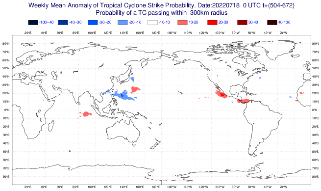
Here are the latest weeklies, increase in TD probability but ACE still average to below-average for NATL. EPAC still looks hyperactive in first week of August.

Image
Image
Image
Image
Image
0 likes   

User avatar
skyline385
Category 5
Category 5
Posts: 2728
Age: 34
Joined: Wed Aug 26, 2020 11:15 pm
Location: Houston TX

Re: 2022 Indicators (SSTs/SAL/MSLP/Shear/Steering/Instability) and >Day 16 Models

#1855 Postby skyline385 » Mon Jul 18, 2022 3:11 pm

EURO still not backing off from that strong ridging, everything seems to be crashing into SA in late August in the weekly precipitation plots.

Image
Image
Image
Image
0 likes   

User avatar
SFLcane
S2K Supporter
S2K Supporter
Posts: 10162
Age: 47
Joined: Sat Jun 05, 2010 1:44 pm
Location: Lake Worth Florida

Re: 2022 Indicators (SSTs/SAL/MSLP/Shear/Steering/Instability) and >Day 16 Models

#1856 Postby SFLcane » Mon Jul 18, 2022 3:11 pm

New EPS weekliess showing the epac party continuing it seems with the Atlantic mdr very surpressed.
0 likes   

User avatar
SFLcane
S2K Supporter
S2K Supporter
Posts: 10162
Age: 47
Joined: Sat Jun 05, 2010 1:44 pm
Location: Lake Worth Florida

Re: 2022 Indicators (SSTs/SAL/MSLP/Shear/Steering/Instability) and >Day 16 Models

#1857 Postby SFLcane » Mon Jul 18, 2022 3:17 pm

I wouldn't be surprised to see Phil K's August numbers drop a bit.
0 likes   

User avatar
SFLcane
S2K Supporter
S2K Supporter
Posts: 10162
Age: 47
Joined: Sat Jun 05, 2010 1:44 pm
Location: Lake Worth Florida

Re: 2022 Indicators (SSTs/SAL/MSLP/Shear/Steering/Instability) and >Day 16 Models

#1858 Postby SFLcane » Mon Jul 18, 2022 3:20 pm

Pipeline into the EPAC into mid August if this is correct.

Image
0 likes   

User avatar
Category5Kaiju
Category 5
Category 5
Posts: 4052
Joined: Thu Dec 24, 2020 12:45 pm
Location: Seattle

Re: 2022 Indicators (SSTs/SAL/MSLP/Shear/Steering/Instability) and >Day 16 Models

#1859 Postby Category5Kaiju » Mon Jul 18, 2022 3:36 pm

How the heck is the EPAC expected to be that active while the Atlantic and even the WPAC remain suppressed (let alone in a third year La Niña and with the EPAC sst anomalies not glaringly warm) is my question lol
0 likes   
Unless explicitly stated, all info in my posts is based on my own opinions and observations. Tropical storms and hurricanes can be extremely dangerous. Do not think you can beat Mother Nature. Refer to an accredited weather research agency or meteorologist if you need to make serious decisions regarding an approaching storm.

User avatar
SFLcane
S2K Supporter
S2K Supporter
Posts: 10162
Age: 47
Joined: Sat Jun 05, 2010 1:44 pm
Location: Lake Worth Florida

Re: 2022 Indicators (SSTs/SAL/MSLP/Shear/Steering/Instability) and >Day 16 Models

#1860 Postby SFLcane » Mon Jul 18, 2022 3:38 pm

Category5Kaiju wrote:How the heck is the EPAC expected to be that active while the Atlantic and even the WPAC remain suppressed (let alone in a third year La Niña and with the EPAC sst anomalies not glaringly warm) is my question lol


Guess it's the low-lat wave track maybe? EPAC will probably quiet down at some point though
0 likes   


Return to “Talkin' Tropics”

Who is online

Users browsing this forum: Long John, RomP and 183 guests