2022 Indicators (SSTs/SAL/MSLP/Shear/Steering/Instability) and >Day 16 Models
Moderator: S2k Moderators
Forum rules

The posts in this forum are NOT official forecasts and should not be used as such. They are just the opinion of the poster and may or may not be backed by sound meteorological data. They are NOT endorsed by any professional institution or STORM2K. For official information, please refer to products from the National Hurricane Center and National Weather Service.
-
Category5Kaiju

- Category 5

- Posts: 4313
- Joined: Thu Dec 24, 2020 12:45 pm
- Location: Seattle and Phoenix
Re: 2022 Indicators (SSTs/SAL/MSLP/Shear/Steering/Instability) and >Day 16 Models
2017 was literally Houston's, the Key's, and Puerto Rico's worst nightmare all in one. If not 2005, 2017 is quite understandably another so-called "boogeyman" year 
4 likes
Unless explicitly stated, all info in my posts is based on my own opinions and observations. Tropical storms and hurricanes can be extremely dangerous. Refer to an accredited weather research agency or meteorologist if you need to make serious decisions regarding an approaching storm.
-
skyline385

- Category 5
- Posts: 2728
- Age: 35
- Joined: Wed Aug 26, 2020 11:15 pm
- Location: Houston TX
Re: 2022 Indicators (SSTs/SAL/MSLP/Shear/Steering/Instability) and >Day 16 Models
Hope everyone is ready for peak season

3 likes
-
Category5Kaiju
- Category 5
- Posts: 4313
- Joined: Thu Dec 24, 2020 12:45 pm
- Location: Seattle and Phoenix
Re: 2022 Indicators (SSTs/SAL/MSLP/Shear/Steering/Instability) and >Day 16 Models
I can smell the Irma, Floyd, and Hugo comparisons coming
0 likes
Unless explicitly stated, all info in my posts is based on my own opinions and observations. Tropical storms and hurricanes can be extremely dangerous. Refer to an accredited weather research agency or meteorologist if you need to make serious decisions regarding an approaching storm.

Re: 2022 Indicators (SSTs/SAL/MSLP/Shear/Steering/Instability) and >Day 16 Models
InfernoFlameCat wrote:Storms have stopped moving west to east here in Georgia. Last time that happened was 2017. So I’m getting enormous amounts of rain because of stalled frontal boundaries. Strong ridge out there. I’ll take the 15 inches of rain I have gotten this month but geez. Florida better watch out. Could we see something like Andrew this year. I haven’t seen that storm mentioned.
This is honestly a hunch of mine too, been thinking something like Andrew might happen this year for quite some time. Also have a feeling it could come later, like September into October. Just my $ 0.02
0 likes
Georges '98, Irene '99, Frances '04, Jeanne '04, Katrina '05, Wilma '05, Gustav '08, Isaac '12, Matthew '16, Florence '18, Michael '18, Ian '22

Re: 2022 Indicators (SSTs/SAL/MSLP/Shear/Steering/Instability) and >Day 16 Models
Some of the latest CFS trends are showing a continued slow-ish season up until late August, and then frequent MDR storms through the middle of October, and possibly a very backloaded MDR season
0 likes
The above post is not official and should not be used as such. It is the opinion of the poster and may or may not be backed by sound meteorological data. It is not endorsed by any professional institution or storm2k.org. For official information, please refer to the NHC and NWS products.


Re: 2022 Indicators (SSTs/SAL/MSLP/Shear/Steering/Instability) and >Day 16 Models
Hammy wrote:Some of the latest CFS trends are showing a continued slow-ish season up until late August, and then frequent MDR storms through the middle of October, and possibly a very backloaded MDR season
Today’s CFS run specifically shows a hyperactive peak season starting in the last days of August. There are three instances of long-tracking majors: very late August into early September, then Sept 11-20th, and finally mid-October. The amount of activity forecast for October is likely unrealistically excessive; I don’t think a trio of simultaneously active MDR storms in October has ever happened before. This run’s forecasted September activity would give 2020 a run for its money, quite a contrast from a nearly dead September from many other recent runs.
What’s worrying is how many CFS runs have shown long-tracking storms getting uncomfortably close to the East Coast and New England. It could be sniffing out a steering pattern we’ll have to watch out for. Additionally, it has been showing a long-tracking system going into Atlantic Canada or New England between late August and early September for the last few weeks now.
2 likes
Irene '11 Sandy '12 Hermine '16 5/15/2018 Derecho Fay '20 Isaias '20 Elsa '21 Henri '21 Ida '21
I am only a meteorology enthusiast who knows a decent amount about tropical cyclones. Look to the professional mets, the NHC, or your local weather office for the best information.
I am only a meteorology enthusiast who knows a decent amount about tropical cyclones. Look to the professional mets, the NHC, or your local weather office for the best information.
-
skyline385
- Category 5
- Posts: 2728
- Age: 35
- Joined: Wed Aug 26, 2020 11:15 pm
- Location: Houston TX
-
Deshaunrob17
- Tropical Storm

- Posts: 211
- Joined: Tue Aug 18, 2020 7:49 am
Re: 2022 Indicators (SSTs/SAL/MSLP/Shear/Steering/Instability) and >Day 16 Models
Category5Kaiju wrote:LemieT wrote:I have a habit of watching old videos from prior seasons to give me a reminder of in-situ conditions at those times. I recommend watching all of Mark Sudduth's July Hurricane Outlook and Discussion videos from 2017. It should keep some occupied but you see some very interesting similarities with our current state. Someone mentioned a few days ago on this thread that this year could be a sort of 2017 lite. I am beginning to think it's possible. Not bats**t crazy ACE but a genuine active season with heavy deep tropics
formation. FWIW if we think the EPACs activity is a negative factor, by today in 2017, the EPAC was already at Hilary with Irwin forming the next day. In that list were two majors and a Cat 2. We all have a little 2013 jitters but I am willing to bet this year ain't it.
Indeed; I did the same with the 2019 and 2021 hurricanetrack videos and the S2K discussions during this timeframe (both of those years had dead late Julys and even early-Augusts), and there is literally nothing that sticks out to me as being particularly odd about what we're seeing now (maybe aside from the fact that this year seems to be a lot more unfavorable than the previous years for subtropical shorties).
2019 was painful ( not that I am wanting destructive storms) but we had to wait until the end of August for things to really start get going with Dorian. Even then, models weren’t excited with Dorian until Dorian passed the Lesser Antilles… 2018 was sort of painful too, there were some sub tropical activity but the deep tropics was a ghost town until Florence popped up the very end of August....
Those two years really intrigued me because they behave similarly and things flipped the at the end of August.. It's interesting too how they lacked Caribbean activity. I know 2018 had a crazy Epac year so that was responsible
1 likes
-
skyline385
- Category 5
- Posts: 2728
- Age: 35
- Joined: Wed Aug 26, 2020 11:15 pm
- Location: Houston TX
2022 Indicators (SSTs/SAL/MSLP/Shear/Steering/Instability) and >Day 16 Models
SFLcane wrote:
12Z run going to be very interesting
2 likes
-
Category5Kaiju
- Category 5
- Posts: 4313
- Joined: Thu Dec 24, 2020 12:45 pm
- Location: Seattle and Phoenix
Re: 2022 Indicators (SSTs/SAL/MSLP/Shear/Steering/Instability) and >Day 16 Models
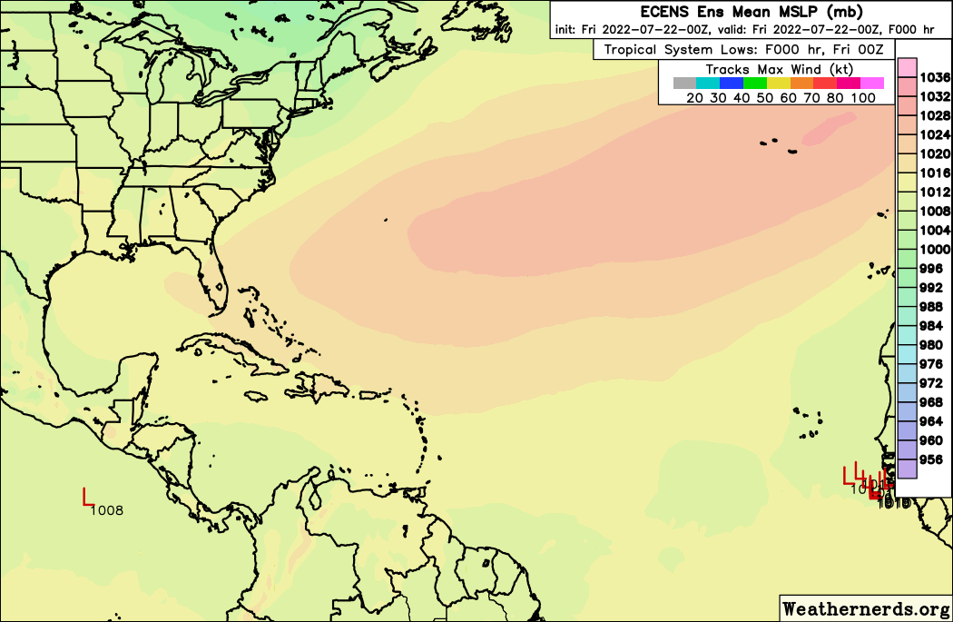
Very interesting to see how the Euro thinks this thing potentially may develop in a week or a bit more. That's not long-range folks.
3 likes
Unless explicitly stated, all info in my posts is based on my own opinions and observations. Tropical storms and hurricanes can be extremely dangerous. Refer to an accredited weather research agency or meteorologist if you need to make serious decisions regarding an approaching storm.
-
DorkyMcDorkface

- Category 4

- Posts: 962
- Age: 28
- Joined: Mon Sep 30, 2019 1:32 pm
- Location: Mid-Atlantic
Re: 2022 Indicators (SSTs/SAL/MSLP/Shear/Steering/Instability) and >Day 16 Models
SFLcane wrote:https://i.postimg.cc/d1N7pvYT/52991816-1.gif
When it comes to these sprawling high-latitude dry waves you have to watch what happens to them once they reach further west (i.e. the magic 50W line where the 26C isotherm rapidly expands northward). If conditions permit there is always the potential for them to develop in the western Atlantic down the line, be it near the Antilles, over the Bahamas, in the Gulf, etc. Either that or the wave could cross the basin innocuously before eventually finding its way into the EPAC and developing there.
Here's an old GIF I made a while back featuring Elena 1985's precursor, showing a large TW shrouded in SAL that eventually fired off convection as it approached the islands.

Irene 2011 was actually quite similar in this regard as well:

10 likes
Please note the thougths expressed by this account are solely those of the user and are from a hobbyist perspective. For more comprehensive analysis, consult an actual professional meteorologist or meteorology agency.
Floyd 1999 | Isabel 2003 | Hanna 2008 | Irene 2011 | Sandy 2012 | Isaias 2020
-
skyline385
- Category 5
- Posts: 2728
- Age: 35
- Joined: Wed Aug 26, 2020 11:15 pm
- Location: Houston TX
Re: 2022 Indicators (SSTs/SAL/MSLP/Shear/Steering/Instability) and >Day 16 Models
DorkyMcDorkface wrote:SFLcane wrote:https://i.postimg.cc/d1N7pvYT/52991816-1.gif
When it comes to these sprawling high-latitude dry waves you have to watch what happens to them once they reach further west (i.e. the magic 50W line where the 26C isotherm rapidly expands northward). If conditions permit there is always the potential for them to develop in the western Atlantic down the line, be it near the Antilles, over the Bahamas, in the Gulf, etc. Either that or the wave could cross the basin innocuously before eventually finding its way into the EPAC and developing there.
Here's an old GIF I made a while back featuring Elena 1985's precursor, showing a large TW shrouded in SAL that eventually fired off convection as it approached the islands.
Irene 2011 was actually quite similar in this regard as well:
While we are talking about high latitude waves
https://twitter.com/andyhazelton/status/1550454759076790274
1 likes
-
ScottNAtlanta

- Category 5
- Posts: 2535
- Joined: Sat May 25, 2013 3:11 pm
- Location: Atlanta, GA
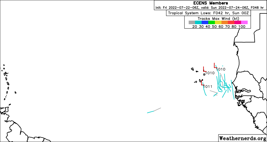
Re: 2022 Indicators (SSTs/SAL/MSLP/Shear/Steering/Instability) and >Day 16 Models
Gotta love that one member that tries to head-but the ridge.

2 likes
The posts in this forum are NOT official forecast and should not be used as such. They are just the opinion of the poster and may or may not be backed by sound meteorological data. They are NOT endorsed by any professional institution or storm2k.org. For official information, please refer to the NHC and NWS products.


Re: 2022 Indicators (SSTs/SAL/MSLP/Shear/Steering/Instability) and >Day 16 Models
So what is that convection north of Hispaniola? Looks like it might be under an upper level high where shear will be lessening. Was going to start a thread but no model support and sometimes these just go poof if they are shear related.
0 likes
-
skyline385
- Category 5
- Posts: 2728
- Age: 35
- Joined: Wed Aug 26, 2020 11:15 pm
- Location: Houston TX
2022 Indicators (SSTs/SAL/MSLP/Shear/Steering/Instability) and >Day 16 Models
I agree with his sentiment (Andrew is the best example of this) but 2020 had 180 ACE, its right there in the Twitter post he is replying to lol. I would be very surprised if a record breaking season ended at 140 ACE.
0 likes
-
Category5Kaiju
- Category 5
- Posts: 4313
- Joined: Thu Dec 24, 2020 12:45 pm
- Location: Seattle and Phoenix
Re: 2022 Indicators (SSTs/SAL/MSLP/Shear/Steering/Instability) and >Day 16 Models
skyline385 wrote:
I agree with his sentiment (Andrew is the best example of this) but 2020 had 180 ACE, its right there in the Twitter post he is replying to lol. I would be very surprised if a record breaking season ended at 140 ACE.
While not record breaking like years such as 2017 or 2005, 2008 ended with 145 ACE (so not hyperactive), but it also had the unique distinction of being the only non-hyperactive year on record since the satellite era (or even dating back at least to the 1920s) to feature at least 5 major hurricanes. It was not operationally hyperactive, but with storms like Gustav, Ike, and Paloma, it sure felt pretty darn close to being one, and with especially Ike, a pretty memorable season too
Last edited by Category5Kaiju on Fri Jul 22, 2022 1:11 pm, edited 1 time in total.
0 likes
Unless explicitly stated, all info in my posts is based on my own opinions and observations. Tropical storms and hurricanes can be extremely dangerous. Refer to an accredited weather research agency or meteorologist if you need to make serious decisions regarding an approaching storm.
Re: 2022 Indicators (SSTs/SAL/MSLP/Shear/Steering/Instability) and >Day 16 Models
The 2022 and 2021 SSTA maps are almost total inverses of each other right now. The exact parts of the Canary Current that were warm last year and now much below-average, and we’ve got a developing Atlantic Nina instead of an Atlantic Niño.
0 likes
Irene '11 Sandy '12 Hermine '16 5/15/2018 Derecho Fay '20 Isaias '20 Elsa '21 Henri '21 Ida '21
I am only a meteorology enthusiast who knows a decent amount about tropical cyclones. Look to the professional mets, the NHC, or your local weather office for the best information.
I am only a meteorology enthusiast who knows a decent amount about tropical cyclones. Look to the professional mets, the NHC, or your local weather office for the best information.
Who is online
Users browsing this forum: bird, KirbyDude25 and 182 guests