2022 Indicators (SSTs/SAL/MSLP/Shear/Steering/Instability) and >Day 16 Models
Moderator: S2k Moderators
Forum rules

The posts in this forum are NOT official forecasts and should not be used as such. They are just the opinion of the poster and may or may not be backed by sound meteorological data. They are NOT endorsed by any professional institution or STORM2K. For official information, please refer to products from the National Hurricane Center and National Weather Service.


Re: 2022 Indicators (SSTs/SAL/MSLP/Shear/Steering/Instability) and >Day 16 Models
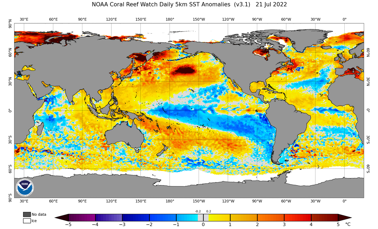
Also don't forget SST anomalies is just a relatively subjective variable. Actual SSTs themselves determine convection. Everything is a gradient on a large scale. 26C and its location, how far north or south than usual plays some role and the gradient will follow.
1 likes
The above post and any post by Ntxw is NOT an official forecast and should not be used as such. It is just the opinion of the poster and may or may not be backed by sound meteorological data. It is NOT endorsed by any professional institution including Storm2k. For official information, please refer to NWS products.
Help support Storm2K!
-
skyline385

- Category 5

- Posts: 2728
- Age: 35
- Joined: Wed Aug 26, 2020 11:15 pm
- Location: Houston TX
Re: 2022 Indicators (SSTs/SAL/MSLP/Shear/Steering/Instability) and >Day 16 Models
Ntxw wrote:Also don't forget SST anomalies is just a relatively subjective variable. Actual SSTs themselves determine convection. Everything is a gradient on a large scale. 26C and it's location, how far north or south than usual plays some role and the gradient will follow.
Yes very much, best and greatest example of this is Andrew


3 likes
-
Category5Kaiju

- Category 5
- Posts: 4313
- Joined: Thu Dec 24, 2020 12:45 pm
- Location: Seattle and Phoenix
Re: 2022 Indicators (SSTs/SAL/MSLP/Shear/Steering/Instability) and >Day 16 Models
skyline385 wrote:Ntxw wrote:Also don't forget SST anomalies is just a relatively subjective variable. Actual SSTs themselves determine convection. Everything is a gradient on a large scale. 26C and it's location, how far north or south than usual plays some role and the gradient will follow.
Yes very much, best and greatest example of this is Andrew
https://uploads.tapatalk-cdn.com/20220722/5270e0453ee01689a3d708f22f78c541.jpg
https://uploads.tapatalk-cdn.com/20220722/e3f73079e3bb3c000bed23e08e8cd69a.jpg
Lorenzo and Michael iirc also intensified into Cat 5 hurricanes over warm but not insane warm waters; roughly 27-28 C or so. In fact, by looking at the WPAC and its swath of 30 C and 31 C waters, you would think it would have had an easy time spamming storms throughout this month. In contrast, Darby didn't really go over extremely warm waters.
The point here is, if you have sea surface temperatures that are 28 C or so, then that alone is enough to allow for a high-end hurricane, especially if the upper-level winds and conditions are cooperative. You don't necessarily need red or orange-color coded zones on the sst anomaly map for a powerhouse storm to happen.
4 likes
Unless explicitly stated, all info in my posts is based on my own opinions and observations. Tropical storms and hurricanes can be extremely dangerous. Refer to an accredited weather research agency or meteorologist if you need to make serious decisions regarding an approaching storm.
-
tolakram
- Admin

- Posts: 20168
- Age: 62
- Joined: Sun Aug 27, 2006 8:23 pm
- Location: Florence, KY (name is Mark)
Re: 2022 Indicators (SSTs/SAL/MSLP/Shear/Steering/Instability) and >Day 16 Models
skyline385 wrote:tolakram wrote:skyline385 wrote:Source for the ACE correlation? It’s from CSU’s forecasts.
I'm reading the latest CSU discussion and can't find the word Canary anywhere. If this is from a particular discussion or verification we'd all benefit from a link to the source.
They don’t talk specifically about the canary current in the discussion but the ACE-SST correlation highlights the impact it has on ACE which is amongst the highest. A cooler canary current simply means systems develop more in the Western Atlantic (and not the E/C Atlantic which is what the tweet above was saying as well) and this pretty much matches the Caribbean season expected as well.
Phil Klotzbach showed the SST chart and ACE comparison in a tweet back in early July.
https://twitter.com/philklotzbach/status/1545062079530418177
Nothing major has changed since that tweet and I see no mention of the Canary current. You see my challenge here. The current is real but is it driving cold temperatures, or simply a current that has nothing to do with the SST's that it carries, it's just a function of the current SST regime. I might be beating a dead horse here, but I think terminology is important. If the current hasn't shifted or somehow changed then the current itself has little bearing on SST's.
2 likes
M a r k
- - - - -
Join us in chat: Storm2K Chatroom Invite. Android and IOS apps also available.
The posts in this forum are NOT official forecasts and should not be used as such. Posts are NOT endorsed by any professional institution or STORM2K.org. For official information and forecasts, please refer to NHC and NWS products.
-
skyline385
- Category 5
- Posts: 2728
- Age: 35
- Joined: Wed Aug 26, 2020 11:15 pm
- Location: Houston TX
Re: 2022 Indicators (SSTs/SAL/MSLP/Shear/Steering/Instability) and >Day 16 Models
Category5Kaiju wrote:skyline385 wrote:Ntxw wrote:Also don't forget SST anomalies is just a relatively subjective variable. Actual SSTs themselves determine convection. Everything is a gradient on a large scale. 26C and it's location, how far north or south than usual plays some role and the gradient will follow.
Yes very much, best and greatest example of this is Andrew
https://uploads.tapatalk-cdn.com/20220722/5270e0453ee01689a3d708f22f78c541.jpg
https://uploads.tapatalk-cdn.com/20220722/e3f73079e3bb3c000bed23e08e8cd69a.jpg
Lorenzo and Michael iirc also intensified into Cat 5 hurricanes over warm but not insane warm waters; roughly 27-28 C or so. In fact, by looking at the WPAC and its swath of 30 C and 31 C waters, you would think it would have had an easy time spamming storms throughout this month. In contrast, Darby didn't really go over extremely warm waters.
The point here is, if you have sea surface temperatures that are 28 C or so, then that alone is enough to allow for a high-end hurricane, especially if the upper-level winds and conditions are cooperative. You don't necessarily need red or orange-color coded zones on the sst anomaly map for a powerhouse storm to happen.
Yes Darby intensified into a Cat 4 over 27C waters iirc. Any hurricane can continue to intensify under ideal conditions as long as the water is above 26C.
But at the same time, there is a clear correlation between SST and seasonal ACE as seen in the CSU discussion. So it remains an important indicator of seasonal activity in terms of ACE. It is not the only indicator and high SST will not guarantee hyperactivity but it is an important one based on objective historical analysis.
0 likes

Re: 2022 Indicators (SSTs/SAL/MSLP/Shear/Steering/Instability) and >Day 16 Models

You can clearly see the effect of a cold Canary Current
0 likes
-
tolakram
- Admin
- Posts: 20168
- Age: 62
- Joined: Sun Aug 27, 2006 8:23 pm
- Location: Florence, KY (name is Mark)
Re: 2022 Indicators (SSTs/SAL/MSLP/Shear/Steering/Instability) and >Day 16 Models

4 likes
M a r k
- - - - -
Join us in chat: Storm2K Chatroom Invite. Android and IOS apps also available.
The posts in this forum are NOT official forecasts and should not be used as such. Posts are NOT endorsed by any professional institution or STORM2K.org. For official information and forecasts, please refer to NHC and NWS products.
- - - - -
Join us in chat: Storm2K Chatroom Invite. Android and IOS apps also available.
The posts in this forum are NOT official forecasts and should not be used as such. Posts are NOT endorsed by any professional institution or STORM2K.org. For official information and forecasts, please refer to NHC and NWS products.
-
cycloneye

- Admin
- Posts: 148740
- Age: 69
- Joined: Thu Oct 10, 2002 10:54 am
- Location: San Juan, Puerto Rico
Re: 2022 Indicators (SSTs/SAL/MSLP/Shear/Steering/Instability) and >Day 16 Models
0 likes
Visit the Caribbean-Central America Weather Thread where you can find at first post web cams,radars
and observations from Caribbean basin members Click Here
and observations from Caribbean basin members Click Here
-
tolakram
- Admin
- Posts: 20168
- Age: 62
- Joined: Sun Aug 27, 2006 8:23 pm
- Location: Florence, KY (name is Mark)
Re: 2022 Indicators (SSTs/SAL/MSLP/Shear/Steering/Instability) and >Day 16 Models
I found it difficult to line up perfectly but here's an overlay of that old current chart and the latest SST anomalies.

4 likes
M a r k
- - - - -
Join us in chat: Storm2K Chatroom Invite. Android and IOS apps also available.
The posts in this forum are NOT official forecasts and should not be used as such. Posts are NOT endorsed by any professional institution or STORM2K.org. For official information and forecasts, please refer to NHC and NWS products.
- - - - -
Join us in chat: Storm2K Chatroom Invite. Android and IOS apps also available.
The posts in this forum are NOT official forecasts and should not be used as such. Posts are NOT endorsed by any professional institution or STORM2K.org. For official information and forecasts, please refer to NHC and NWS products.
-
cycloneye
- Admin
- Posts: 148740
- Age: 69
- Joined: Thu Oct 10, 2002 10:54 am
- Location: San Juan, Puerto Rico
Re: 2022 Indicators (SSTs/SAL/MSLP/Shear/Steering/Instability) and >Day 16 Models
0 likes
Visit the Caribbean-Central America Weather Thread where you can find at first post web cams,radars
and observations from Caribbean basin members Click Here
and observations from Caribbean basin members Click Here
-
weeniepatrol

- Category 5
- Posts: 1339
- Joined: Sat Aug 22, 2020 5:30 pm
- Location: WA State
Re: 2022 Indicators (SSTs/SAL/MSLP/Shear/Steering/Instability) and >Day 16 Models
zzh wrote:https://i.imgur.com/927A85x.gif
You can clearly see the effect of a cold Canary Current
This product has been broken for at least five years, though
Or at least. Had absolutely zero bearing on the above-average after above-average seasons in recent years
0 likes
-
weeniepatrol
- Category 5
- Posts: 1339
- Joined: Sat Aug 22, 2020 5:30 pm
- Location: WA State
Re: 2022 Indicators (SSTs/SAL/MSLP/Shear/Steering/Instability) and >Day 16 Models
tolakram wrote:I found it difficult to line up perfectly but here's an overlay of that old current chart and the latest SST anomalies.
https://i.imgur.com/IMIZSDH.png
I don't think it means much; it's just the usual July handwringing. As usual come late August the last thing we will need to worry about is SSTs... lol
Recall hurricane Florence tracking, and rapidly intensifying, over these waters.

3 likes
-
wxman57

- Moderator-Pro Met

- Posts: 23126
- Age: 68
- Joined: Sat Jun 21, 2003 8:06 pm
- Location: Houston, TX (southwest)
Re: 2022 Indicators (SSTs/SAL/MSLP/Shear/Steering/Instability) and >Day 16 Models
Models all have a strong wave moving off the west coast of Africa next Monday night then moving across the Cape Verde Islands. Beyond then, it's no longer a closed low, just a wave axis. Still a bit too early. Enjoying the quiet.
3 likes
-
gatorcane

- S2K Supporter

- Posts: 23703
- Age: 47
- Joined: Sun Mar 13, 2005 3:54 pm
- Location: Boca Raton, FL
Re: 2022 Indicators (SSTs/SAL/MSLP/Shear/Steering/Instability) and >Day 16 Models
SST anomalies looks to support an active deep MDR between the Lesser Antilles and Africa. Expecting tracks through the Caribbean and also those towards Bahamas/Fl. Bermuda High looks strong this year (see my post yesterday).
0 likes
-
Category5Kaiju
- Category 5
- Posts: 4313
- Joined: Thu Dec 24, 2020 12:45 pm
- Location: Seattle and Phoenix
Re: 2022 Indicators (SSTs/SAL/MSLP/Shear/Steering/Instability) and >Day 16 Models
https://twitter.com/AndyHazelton/status/1550653412743827461
Even Andy admits it; there's nothing about the dry conditions that we're seeing now that is alarming.
In fact, he points out this rather interesting observation; I genuinely wonder why that has been so though.
Even Andy admits it; there's nothing about the dry conditions that we're seeing now that is alarming.
In fact, he points out this rather interesting observation; I genuinely wonder why that has been so though.
1 likes
Unless explicitly stated, all info in my posts is based on my own opinions and observations. Tropical storms and hurricanes can be extremely dangerous. Refer to an accredited weather research agency or meteorologist if you need to make serious decisions regarding an approaching storm.
Re: 2022 Indicators (SSTs/SAL/MSLP/Shear/Steering/Instability) and >Day 16 Models
weeniepatrol wrote:zzh wrote:https://i.imgur.com/927A85x.gif
You can clearly see the effect of a cold Canary Current
This product has been broken for at least five years, though
Or at least. Had absolutely zero bearing on the above-average after above-average seasons in recent years
No, this one is not broken.

This is the one that is broken because it includes too many land areas that do not represent tropical Atlantic.
4 likes
-
weeniepatrol
- Category 5
- Posts: 1339
- Joined: Sat Aug 22, 2020 5:30 pm
- Location: WA State
Re: 2022 Indicators (SSTs/SAL/MSLP/Shear/Steering/Instability) and >Day 16 Models
zzh wrote:This is the one that is broken because it includes too many land areas that do not represent tropical Atlantic.

Thanks for the correction; however I still maintain that a snapshot on 22 July doesn't have much of a bearing on the actual season given that we've observed in recent years. Some examples...

Pre-season 2019? Below-average instability.
July 2020? Below-average instability.
10 Sep 2017? Below-average instability.
Stick a fork in it...
4 likes
-
toad strangler

- S2K Supporter
- Posts: 4546
- Joined: Sun Jul 28, 2013 3:09 pm
- Location: Earth
- Contact:
-
crownweather

- S2K Supporter
- Posts: 602
- Age: 51
- Joined: Sat Aug 12, 2006 9:21 am
- Location: Sturbridge, Massachusetts
- Contact:
Re: 2022 Indicators (SSTs/SAL/MSLP/Shear/Steering/Instability) and >Day 16 Models
toad strangler wrote:yawn
http://twitter.com/mjventrice/status/1550873653671256066?s=21&t=aquGsYXITvRBFzZT7jT_mw
This almost looks like cherry picking and throwing out the 2013 reference just for giggles. I took a look at both the current and forecast (by NMME) SST analogs on Levi's site and a few years actually match up to both parameters (and it's not 2013). Those years are 1970, 1971, 2010 and 2011. Average ACE for those 4 years is 107.123.
4 likes
Rob Lightbown
Crown Weather Services
https://crownweather.com
Crown Weather Services
https://crownweather.com
-
Hurricaneman

- Category 5
- Posts: 7404
- Age: 45
- Joined: Tue Aug 31, 2004 3:24 pm
- Location: central florida
Re: 2022 Indicators (SSTs/SAL/MSLP/Shear/Steering/Instability) and >Day 16 Models
I honestly think this year is what 2013 could have been if the season didn’t stay in a spring pattern, actually a very dangerous setup
3 likes
Who is online
Users browsing this forum: No registered users and 129 guests