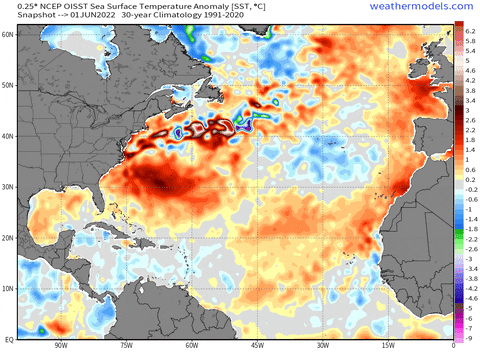
ENSO wise, 2022 and 2013 are very different. Also Atlantic SST configuration is different.
TropicalTidbits hasn't updated the season analogs since 2014 if I'm not mistaken.
Its becoming some sort of trolling thing on Twitter.
2022 Indicators (SSTs/SAL/MSLP/Shear/Steering/Instability) and >Day 16 Models
Moderator: S2k Moderators
Forum rules

The posts in this forum are NOT official forecasts and should not be used as such. They are just the opinion of the poster and may or may not be backed by sound meteorological data. They are NOT endorsed by any professional institution or STORM2K. For official information, please refer to products from the National Hurricane Center and National Weather Service.
-
Kingarabian

- S2K Supporter

- Posts: 16350
- Joined: Sat Aug 08, 2009 3:06 am
- Location: Honolulu, Hawaii
Re: 2022 Indicators (SSTs/SAL/MSLP/Shear/Steering/Instability) and >Day 16 Models
8 likes
RIP Kobe Bryant
-
NotSparta

- Professional-Met

- Posts: 1677
- Age: 24
- Joined: Fri Aug 18, 2017 8:24 am
- Location: Naples, FL
- Contact:
Re: 2022 Indicators (SSTs/SAL/MSLP/Shear/Steering/Instability) and >Day 16 Models
Kingarabian wrote:ENSO wise, 2022 and 2013 are very different. Also Atlantic SST configuration is different.
TropicalTidbits hasn't updated the season analogs since 2014 if I'm not mistaken.
Its becoming some sort of trolling thing on Twitter.
There's a latent amount of trolling about 2013 every July, but the SST pattern kind of looking like it right now that is getting turned up to 11. Eventually once activity picks up the comparisons will go away
0 likes
This post was probably an opinion of mine, and in no way is official. Please refer to http://www.hurricanes.gov for official tropical analysis and advisories.
My website, with lots of tropical wx graphics, including satellite and recon: http://cyclonicwx.com
My website, with lots of tropical wx graphics, including satellite and recon: http://cyclonicwx.com
-
InfernoFlameCat

- Category 5

- Posts: 2127
- Age: 22
- Joined: Mon Dec 14, 2020 10:52 am
- Location: Buford, GA
Re: 2022 Indicators (SSTs/SAL/MSLP/Shear/Steering/Instability) and >Day 16 Models
this season might be what 2013 was supposed to be
6 likes
I am by no means a professional. DO NOT look at my forecasts for official information or make decisions based on what I post.
Goal: to become a registered expert over tropical and subtropical cyclones.
Goal: to become a registered expert over tropical and subtropical cyclones.
-
ScottNAtlanta

- Category 5
- Posts: 2535
- Joined: Sat May 25, 2013 3:11 pm
- Location: Atlanta, GA
Re: 2022 Indicators (SSTs/SAL/MSLP/Shear/Steering/Instability) and >Day 16 Models
Some more about the Canary Current (and why it probably isn't a factor)
So the Canary Current all but disappears in the summer as the trade winds weaken.
If you want to read the full article
https://oceancurrents.rsmas.miami.edu/a ... anary.html
During winter the trade winds are at their peak strength, and so is the Canary Current. Its core velocity can be more than 75 cm s-1 as it passes through the Canary archipelago. It moves parallel to the coastline up to 20°N, forming cyclonic gyres on the shelf along the way. When the current reaches the area of 15°N, it begins to flow west under the influence of the Equatorial Countercurrent. Although the two currents flow in the same direction, they do so at different speeds; this causes two anti-cyclonic gyres to form at the border between them. In spring the Canary Current weakens along with the trade winds, while the Equatorial Countercurrent strengthens. An anti-cyclonic gyre forms to the west of the current. The summer brings about further weakening of the trade winds, and this reduces the water inflow from the north. The Canary Current weakens further and spreads outward from the coast. The cyclonic gyres on the shelf weaken or disappear completely. The Equatorial Countercurrent, on the other hand, is at its peak and shifts north, separating the Canary Current from the coast. During autumn the Canary Current is at its weakest, but some of its characteristics are very similar to those during winter. The current passes through the Canary archipelago, the influence of the Equatorial Countercurrent is the same as in winter, and the strong cyclonic gyres form once again.
So the Canary Current all but disappears in the summer as the trade winds weaken.
If you want to read the full article
https://oceancurrents.rsmas.miami.edu/a ... anary.html
3 likes
The posts in this forum are NOT official forecast and should not be used as such. They are just the opinion of the poster and may or may not be backed by sound meteorological data. They are NOT endorsed by any professional institution or storm2k.org. For official information, please refer to the NHC and NWS products.
-
tolakram
- Admin

- Posts: 20179
- Age: 62
- Joined: Sun Aug 27, 2006 8:23 pm
- Location: Florence, KY (name is Mark)
Re: 2022 Indicators (SSTs/SAL/MSLP/Shear/Steering/Instability) and >Day 16 Models
toad strangler wrote:yawn
http://twitter.com/mjventrice/status/1550873653671256066?s=21&t=aquGsYXITvRBFzZT7jT_mw
The thread is more interesting, the tweet started a conversation.
https://twitter.com/EricBlake12/status/1548846413173473287
https://twitter.com/AndyHazelton/status/1548844933615853569
1 likes
M a r k
- - - - -
Join us in chat: Storm2K Chatroom Invite. Android and IOS apps also available.
The posts in this forum are NOT official forecasts and should not be used as such. Posts are NOT endorsed by any professional institution or STORM2K.org. For official information and forecasts, please refer to NHC and NWS products.

Re: 2022 Indicators (SSTs/SAL/MSLP/Shear/Steering/Instability) and >Day 16 Models
The Canary Current never disappears. It only weakens during summer.
A warmer Canary Current is needed to form an AMO+ horseshoe pattern, and we know that pattern usually means a high end hurricane season.

Here is a correlation map from Eric Webb.
A warmer Canary Current is needed to form an AMO+ horseshoe pattern, and we know that pattern usually means a high end hurricane season.
Here is a correlation map from Eric Webb.
2 likes
-
tolakram
- Admin
- Posts: 20179
- Age: 62
- Joined: Sun Aug 27, 2006 8:23 pm
- Location: Florence, KY (name is Mark)
Re: 2022 Indicators (SSTs/SAL/MSLP/Shear/Steering/Instability) and >Day 16 Models
In addition I think it's fair to question just how similar the SST pattern is.


That warm area will kill the season.
That cold area will kill the season.
Just seems to me like there's not a lot to go on here.
That warm area will kill the season.
That cold area will kill the season.
Just seems to me like there's not a lot to go on here.
7 likes
M a r k
- - - - -
Join us in chat: Storm2K Chatroom Invite. Android and IOS apps also available.
The posts in this forum are NOT official forecasts and should not be used as such. Posts are NOT endorsed by any professional institution or STORM2K.org. For official information and forecasts, please refer to NHC and NWS products.
- - - - -
Join us in chat: Storm2K Chatroom Invite. Android and IOS apps also available.
The posts in this forum are NOT official forecasts and should not be used as such. Posts are NOT endorsed by any professional institution or STORM2K.org. For official information and forecasts, please refer to NHC and NWS products.
-
Category5Kaiju

- Category 5
- Posts: 4331
- Joined: Thu Dec 24, 2020 12:45 pm
- Location: Seattle and Phoenix
Re: 2022 Indicators (SSTs/SAL/MSLP/Shear/Steering/Instability) and >Day 16 Models
Just an observation, but I will say if anybody thinks what we're seeing now in the Atlantic is strange and not typical of a busy season, then one should simply look at the WPAC, which has not had a single NS since very early July and with no major indications of such anytime soon! That imho is even weirder
8 likes
Unless explicitly stated, all info in my posts is based on my own opinions and observations. Tropical storms and hurricanes can be extremely dangerous. Refer to an accredited weather research agency or meteorologist if you need to make serious decisions regarding an approaching storm.
-
InfernoFlameCat
- Category 5
- Posts: 2127
- Age: 22
- Joined: Mon Dec 14, 2020 10:52 am
- Location: Buford, GA
Re: 2022 Indicators (SSTs/SAL/MSLP/Shear/Steering/Instability) and >Day 16 Models
Its warm! season canceled. Its cold! season canceled. Its incredibly favorable! Well, 2013 was supposed to be- season canceled. Well I guess the season is canceled. 
12 likes
I am by no means a professional. DO NOT look at my forecasts for official information or make decisions based on what I post.
Goal: to become a registered expert over tropical and subtropical cyclones.
Goal: to become a registered expert over tropical and subtropical cyclones.
-
tolakram
- Admin
- Posts: 20179
- Age: 62
- Joined: Sun Aug 27, 2006 8:23 pm
- Location: Florence, KY (name is Mark)
Re: 2022 Indicators (SSTs/SAL/MSLP/Shear/Steering/Instability) and >Day 16 Models
The 2013 WPAC season was super busy as well.
3 likes
M a r k
- - - - -
Join us in chat: Storm2K Chatroom Invite. Android and IOS apps also available.
The posts in this forum are NOT official forecasts and should not be used as such. Posts are NOT endorsed by any professional institution or STORM2K.org. For official information and forecasts, please refer to NHC and NWS products.
- - - - -
Join us in chat: Storm2K Chatroom Invite. Android and IOS apps also available.
The posts in this forum are NOT official forecasts and should not be used as such. Posts are NOT endorsed by any professional institution or STORM2K.org. For official information and forecasts, please refer to NHC and NWS products.
-
Category5Kaiju
- Category 5
- Posts: 4331
- Joined: Thu Dec 24, 2020 12:45 pm
- Location: Seattle and Phoenix
Re: 2022 Indicators (SSTs/SAL/MSLP/Shear/Steering/Instability) and >Day 16 Models
tolakram wrote:The 2013 WPAC season was super busy as well.
Exactly; and if memory serves correctly, the WPAC was still producing systems in July back then.
It is interesting to see how a basin that is typically supposed to be somewhat active even during a La Nina is completely silent during a time of the year when we would expect at least several NSs to happen; 1998 and 2010 come to mind thus far regarding this kind of behavior (even though they are not perfect analogs of what we've been seeing).
Interesting to see how 1998 and 2010 were also very active Atlantic years.
0 likes
Unless explicitly stated, all info in my posts is based on my own opinions and observations. Tropical storms and hurricanes can be extremely dangerous. Refer to an accredited weather research agency or meteorologist if you need to make serious decisions regarding an approaching storm.

Re: 2022 Indicators (SSTs/SAL/MSLP/Shear/Steering/Instability) and >Day 16 Models
Category5Kaiju wrote:tolakram wrote:The 2013 WPAC season was super busy as well.
Exactly; and if memory serves correctly, the WPAC was still producing systems in July back then.
It is interesting to see how a basin that is typically supposed to be somewhat active even during a La Nina is completely silent during a time of the year when we would expect at least several NSs to happen; 1998 and 2010 come to mind thus far regarding this kind of behavior (even though they are not perfect analogs of what we've been seeing).
Interesting to see how 1998 and 2010 were also very active Atlantic years.
1999 is another--in fact there was nothing but a short 12 hour depression between June 19 and August 18.
3 likes
The above post is not official and should not be used as such. It is the opinion of the poster and may or may not be backed by sound meteorological data. It is not endorsed by any professional institution or storm2k.org. For official information, please refer to the NHC and NWS products.
-
skyline385

- Category 5
- Posts: 2728
- Age: 35
- Joined: Wed Aug 26, 2020 11:15 pm
- Location: Houston TX
Re: 2022 Indicators (SSTs/SAL/MSLP/Shear/Steering/Instability) and >Day 16 Models
Got this idea off wxtwitter and made a gif of the entire NATL SSTa evolution for the last 50 days (June 01 onwards), its interesting to see how the temperatures have evolved particularly the cold spreading down from the subtropics
1 likes

Re: 2022 Indicators (SSTs/SAL/MSLP/Shear/Steering/Instability) and >Day 16 Models
skyline385 wrote:Got this idea off wxtwitter and made a gif of the entire NATL SSTa evolution for the last 50 days (June 01 onwards), its interesting to see how the temperatures have evolved particularly the cold spreading down from the subtropics
https://media.giphy.com/media/OJJo49uV1YRZazR7uf/giphy.gif
Me personally, I couldn’t care less about what SST’s are east of 60W. In my opinion it’s more concerning to have warmer SST’s west of there which is the case right now. Fish storms are of no interest to me. To be completely honest, no storm really interests me unless it could possibly threaten my area.
6 likes
-
Hurricane Mike
- Category 2

- Posts: 675
- Joined: Tue Apr 10, 2018 7:44 am
Re: 2022 Indicators (SSTs/SAL/MSLP/Shear/Steering/Instability) and >Day 16 Models
It's coming guys. Don't be fooled. Decades of tracking active and inactive hurricane seasons...that switch is gonna flip in a few weeks.
6 likes
-
OuterBanker
- S2K Supporter
- Posts: 1761
- Joined: Wed Feb 26, 2003 10:53 am
- Location: Nags Head, NC
- Contact:
Re: 2022 Indicators (SSTs/SAL/MSLP/Shear/Steering/Instability) and >Day 16 Models
SEASON OVER SEASON OVER
Year after year it's always the signs that all the predictions of a active season aren't going to happen because nothing has in July.
The reality is that the real season is only the eight weeks from Aug 15 to Oct 15. No matter how much we would like it to last longer.
Let's see what happens then.
Year after year it's always the signs that all the predictions of a active season aren't going to happen because nothing has in July.
The reality is that the real season is only the eight weeks from Aug 15 to Oct 15. No matter how much we would like it to last longer.
Let's see what happens then.
5 likes
-
MHC Tracking
- Tropical Storm

- Posts: 203
- Joined: Mon Mar 15, 2021 10:05 am
Re: 2022 Indicators (SSTs/SAL/MSLP/Shear/Steering/Instability) and >Day 16 Models
Hammy wrote:Category5Kaiju wrote:tolakram wrote:The 2013 WPAC season was super busy as well.
Exactly; and if memory serves correctly, the WPAC was still producing systems in July back then.
It is interesting to see how a basin that is typically supposed to be somewhat active even during a La Nina is completely silent during a time of the year when we would expect at least several NSs to happen; 1998 and 2010 come to mind thus far regarding this kind of behavior (even though they are not perfect analogs of what we've been seeing).
Interesting to see how 1998 and 2010 were also very active Atlantic years.
1999 is another--in fact there was nothing but a short 12 hour depression between June 19 and August 18.

8 likes
-
Category5Kaiju
- Category 5
- Posts: 4331
- Joined: Thu Dec 24, 2020 12:45 pm
- Location: Seattle and Phoenix
Re: 2022 Indicators (SSTs/SAL/MSLP/Shear/Steering/Instability) and >Day 16 Models
OuterBanker wrote:SEASON OVER SEASON OVER
Year after year it's always the signs that all the predictions of a active season aren't going to happen because nothing has in July.
The reality is that the real season is only the eight weeks from Aug 15 to Oct 15. No matter how much we would like it to last longer.
Let's see what happens then.
Let's put it this way; I find it very hard to believe that this season will bust, let alone end up as an unexpected major bust like 2013 for one key reason: La Nina. Since the active era began in 1995, there was only 1 La Nina year that had below average ACE: 2007. You can mainly blame the below-average MDR sst anomalies for that (much, much colder than what we're seeing now lol). 2000 and 2011 were slightly above average, but again, those years suffered from a very cool MDR (2011 being slightly warmer, but not close to what we're seeing now).
The key with this year is this: subtropics are cool, MDR is warmish. That alone makes me think that deep tropical activity will be favored down the line. Now as for 2013 comparisons, again, what is the statistical likelihood that this season will do what that season did, in a La Nina year especially? I really cannot see any parallels whatsoever with that season and this year, given our La Nina base state, a more convective Africa, dead WPAC, cooler subtropical Atlantic, and so forth. Nothing suggests to me at this point in time that we're about to see a massive bust, because it's STILL JULY. It would be rather strange if dry air and that stuff were not issues by this point in time.
Now if there's no activity in late August and early September, then maybe we can have these discussions more seriously. But I am willing to bet my house that by August 20 we'll be seeing a very different picture. And if activity actually ends up way less than expected, then we're going to really have to discuss why that was the case even with the La Nina.
4 likes
Unless explicitly stated, all info in my posts is based on my own opinions and observations. Tropical storms and hurricanes can be extremely dangerous. Refer to an accredited weather research agency or meteorologist if you need to make serious decisions regarding an approaching storm.
-
dexterlabio
- Category 5
- Posts: 3503
- Joined: Sat Oct 24, 2009 11:50 pm
Re: 2022 Indicators (SSTs/SAL/MSLP/Shear/Steering/Instability) and >Day 16 Models
tolakram wrote:The 2013 WPAC season was super busy as well.
As a WPAC follower I can say that the first half of that year was very uneventful. There were a bunch of named storms, yes, but they were terribly sheared. That year's first typhoon formed in mid July, which peaked as a Cat4, while the second typhoon formed a month later (also peaked as a Cat4). For WPAC's standards, that is still considered unimpressive.
The 2013 WPAC season only got going during NHem Autumn, with a Cat5 forming in late September and the streak of major phoons culminated with Haiyan in early November.
Nonetheless, it lacks basis to say that the current year will follow a certain year from a distant past, moreso a year that is considered anomalous like 2013.
2 likes
Personal Forecast Disclaimer:
The posts in this forum are NOT official forecast and should not be used as such. They are just the opinion of the poster and may or may not be backed by sound meteorological data. They are NOT endorsed by any professional institution or storm2k.org. For official information, please refer to the NHC and NWS products.
The posts in this forum are NOT official forecast and should not be used as such. They are just the opinion of the poster and may or may not be backed by sound meteorological data. They are NOT endorsed by any professional institution or storm2k.org. For official information, please refer to the NHC and NWS products.
-
dexterlabio
- Category 5
- Posts: 3503
- Joined: Sat Oct 24, 2009 11:50 pm
Re: 2022 Indicators (SSTs/SAL/MSLP/Shear/Steering/Instability) and >Day 16 Models
It is also worth pointing out that should the Atlantic pull off another streak of hyperactivity by late August, a la 2017, this year would easily be one of those rare times when the ATL exceeded WPAC in terms of ACE. There is no way the WPAC can catch up if it stays dead and the Atlantic gets a 2005/2017/2020 redux by August.
Which brings me to another question: how often do we see the ATL get to hyperactive levels like 2017 and 2020? If this happens again this year, wouldn't that be too soon for a reoccurence?
Which brings me to another question: how often do we see the ATL get to hyperactive levels like 2017 and 2020? If this happens again this year, wouldn't that be too soon for a reoccurence?
0 likes
Personal Forecast Disclaimer:
The posts in this forum are NOT official forecast and should not be used as such. They are just the opinion of the poster and may or may not be backed by sound meteorological data. They are NOT endorsed by any professional institution or storm2k.org. For official information, please refer to the NHC and NWS products.
The posts in this forum are NOT official forecast and should not be used as such. They are just the opinion of the poster and may or may not be backed by sound meteorological data. They are NOT endorsed by any professional institution or storm2k.org. For official information, please refer to the NHC and NWS products.
Who is online
Users browsing this forum: jconsor and 71 guests