
I think 2005 has given many people the false idea that an extreme season must have strong hurricanes in June/July in order to become as iconic. But with the exception of a few years, most previous hyperactive seasons were pretty quiet at least until August rolled around. Here below I made an overview of all hyperactive seasons with the following stats: number of named storms before August 1, date of the first hurricane, date of the first major hurricane. While June/July hurricanes are more common in the most extreme seasons, you can see that some of the busiest season didn't have their first hurricane until well into August, let alone their first MH.
Year / NS before August 1 / Date first hurricane / Date first MH
Pre-satellite era:
1878 / 1 / August 15 / September 30
1886 / 4 / June 14 / August 19
1887 / 5 / July 21 / August 20
1893 / 2 / June 17 / August 17
1906 / 2 / June 16 / September 2
1926 / 2 / July 25 / July 25
1932 / 1 / August 13 / August 13
1933 / 5 / June 27 / August 18
1950 / 0 / August 17 / August 17
1961 / 1 / July 20 / September 6
1964 / 3 / August 1 / August 22
Satellite era:
1969 / 1 / August 11 / August 16
1995 / 5 / June 4 / August 12
1996 / 3 / July 7 / July 9
1998 / 1 / August 22 / August 23
1999 / 1 / August 20 / August 22
2003 / 4 / July 14 / August 30
2004 / 1 / August 3 / August 5
2005 / 7 / July 6 / July 7
2010 / 2 / June 30 / August 27
2017 / 5 / August 9 / August 25
2020 / 9 / July 25 / August 26
2022 / 3 / NA / NA
2022 Indicators (SSTs/SAL/MSLP/Shear/Steering/Instability) and >Day 16 Models
Moderator: S2k Moderators
Forum rules

The posts in this forum are NOT official forecasts and should not be used as such. They are just the opinion of the poster and may or may not be backed by sound meteorological data. They are NOT endorsed by any professional institution or STORM2K. For official information, please refer to products from the National Hurricane Center and National Weather Service.
-
Iceresistance

- Category 5

- Posts: 9579
- Age: 22
- Joined: Sat Oct 10, 2020 9:45 am
- Location: Tecumseh, OK/Norman, OK
Re: 2022 Indicators (SSTs/SAL/MSLP/Shear/Steering/Instability) and >Day 16 Models
SSTs appear be above 30°C in the Gulf of Mexico already.
Still below normal in the MDR region, likely miscalculating from the amount of dust is in the air from the Sahara.
Still below normal in the MDR region, likely miscalculating from the amount of dust is in the air from the Sahara.
0 likes
Bill 2015 & Beta 2020
Winter 2020-2021
All observations are in Tecumseh, OK unless otherwise noted.
Winter posts are focused mainly for Oklahoma & Texas.
Take any of my forecasts with a grain of salt, refer to the NWS, SPC, and NHC for official information
Never say Never with weather! Because ANYTHING is possible!
Winter 2020-2021
All observations are in Tecumseh, OK unless otherwise noted.
Winter posts are focused mainly for Oklahoma & Texas.
Take any of my forecasts with a grain of salt, refer to the NWS, SPC, and NHC for official information
Never say Never with weather! Because ANYTHING is possible!
-
skyline385

- Category 5
- Posts: 2728
- Age: 35
- Joined: Wed Aug 26, 2020 11:15 pm
- Location: Houston TX
Re: 2022 Indicators (SSTs/SAL/MSLP/Shear/Steering/Instability) and >Day 16 Models
Iceresistance wrote:SSTs appear be above 30°C in the Gulf of Mexico already.
Still below normal in the MDR region, likely miscalculating from the amount of dust is in the air from the Sahara.
What’s funny is that the Gulf SSTa have actually cooled down a bit in the last month even though almost all of it is above 30C. It’s still running above average but the anomalies were much higher just a few days ago.

0 likes

Re: 2022 Indicators (SSTs/SAL/MSLP/Shear/Steering/Instability) and >Day 16 Models
IMHO all I know is that during the next 10-14 days at least the western MDR is going to continue to be shut down with stronger than average shear, this is not the typical La Nina pattern we would see as we head into to August especially since El Nino hasn't been around since 2019.
I just came back from vacationing in Cancun, when I booked this trip back in April I thought that I had made a bad decision, I thought for sure that by late July there was going to be a threat across the Caribbean for tropical development, instead I saw just a couple of tropical showers pass by that rain themselves out from the dry environment which was surprising because there was no dust at all present.

I just came back from vacationing in Cancun, when I booked this trip back in April I thought that I had made a bad decision, I thought for sure that by late July there was going to be a threat across the Caribbean for tropical development, instead I saw just a couple of tropical showers pass by that rain themselves out from the dry environment which was surprising because there was no dust at all present.
3 likes
-
Category5Kaiju

- Category 5
- Posts: 4331
- Joined: Thu Dec 24, 2020 12:45 pm
- Location: Seattle and Phoenix
Re: 2022 Indicators (SSTs/SAL/MSLP/Shear/Steering/Instability) and >Day 16 Models
NDG wrote:IMHO all I know is that during the next 10-14 days at least the western MDR is going to continue to be shut down with stronger than average shear, this is not the typical La Nina pattern we would see as we head into to August especially since El Nino hasn't been around since 2019.
I just came back from vacationing in Cancun, when I booked this trip back in April I thought that I had made a bad decision, I thought for sure that by late July there was going to be a threat across the Caribbean for tropical development, instead I saw just a couple of tropical showers pass by that rain themselves out from the dry environment which was surprising because there was no dust at all present.
https://i.imgur.com/BnSmUYG.gif
Aren't shear forecasts that go out that far in advance not to be taken at face value though? Shear is very dynamic, and I remember how people were cautioning about how shear forecasts that far out in time can oftentimes not be very reliable in last year's indicators thread
10 likes
Unless explicitly stated, all info in my posts is based on my own opinions and observations. Tropical storms and hurricanes can be extremely dangerous. Refer to an accredited weather research agency or meteorologist if you need to make serious decisions regarding an approaching storm.
-
Hypercane_Kyle

- Category 5
- Posts: 3465
- Joined: Sat Mar 07, 2015 7:58 pm
- Location: Cape Canaveral, FL
Re: 2022 Indicators (SSTs/SAL/MSLP/Shear/Steering/Instability) and >Day 16 Models
IMHO, one only needs to look to 2017 & 2004. Neither season started off very impressive... until mid-August when all hell broke loose 
2 likes
My posts are my own personal opinion, defer to the National Hurricane Center (NHC) and other NOAA products for decision making during hurricane season.
-
MHC Tracking
- Tropical Storm

- Posts: 203
- Joined: Mon Mar 15, 2021 10:05 am
Re: 2022 Indicators (SSTs/SAL/MSLP/Shear/Steering/Instability) and >Day 16 Models
Iceresistance wrote:SSTs appear be above 30°C in the Gulf of Mexico already.
Still below normal in the MDR region, likely miscalculating from the amount of dust is in the air from the Sahara.
They are not below average in the MDR, only in the subtropics

5 likes
-
cycloneye

- Admin

- Posts: 149291
- Age: 69
- Joined: Thu Oct 10, 2002 10:54 am
- Location: San Juan, Puerto Rico
Re: 2022 Indicators (SSTs/SAL/MSLP/Shear/Steering/Instability) and >Day 16 Models
MHC Tracking wrote:Iceresistance wrote:SSTs appear be above 30°C in the Gulf of Mexico already.
Still below normal in the MDR region, likely miscalculating from the amount of dust is in the air from the Sahara.
They are not below average in the MDR, only in the subtropics
https://coralreefwatch.noaa.gov/data/5km/v3.1/image/daily/ssta/gif/2022/coraltemp5km_ssta_20220725_large.gif
Is that area of blue in the equator the Atlantic La Niña?
1 likes
Visit the Caribbean-Central America Weather Thread where you can find at first post web cams,radars
and observations from Caribbean basin members Click Here
and observations from Caribbean basin members Click Here
-
MHC Tracking
- Tropical Storm
- Posts: 203
- Joined: Mon Mar 15, 2021 10:05 am
Re: 2022 Indicators (SSTs/SAL/MSLP/Shear/Steering/Instability) and >Day 16 Models
cycloneye wrote:MHC Tracking wrote:Iceresistance wrote:SSTs appear be above 30°C in the Gulf of Mexico already.
Still below normal in the MDR region, likely miscalculating from the amount of dust is in the air from the Sahara.
They are not below average in the MDR, only in the subtropics
https://coralreefwatch.noaa.gov/data/5km/v3.1/image/daily/ssta/gif/2022/coraltemp5km_ssta_20220725_large.gif
Is that area of blue in the equator the Atlantic La Niña?
Yes, the cooler than average SST's near the Gulf Of Guinea indicate the Atlantic Nina
0 likes
-
SFLcane

- S2K Supporter

- Posts: 10281
- Age: 48
- Joined: Sat Jun 05, 2010 1:44 pm
- Location: Lake Worth Florida
Re: 2022 Indicators (SSTs/SAL/MSLP/Shear/Steering/Instability) and >Day 16 Models
Was not sure were to leave this article but i thought it was interesting as it speaks about current and expected condtions across the tropical atlantic from John Morales
It’s all about perception, though. We’ve had three named storms so far, where the normal by this date is two. We’ve had zero hurricanes, where the normal by this date is also zero. You read that right—the first hurricane of the Atlantic season on average shows up by August 11. From this measure, the season is pretty much behaving as a hurricane season should
Despite Perceived Slow Start, 2022 Hurricane Season Behaving Normally
https://www.nbcmiami.com/weather/hurric ... y/2822047/
6 likes
-
hurricane2025
- Category 1

- Posts: 254
- Joined: Thu Apr 08, 2021 10:36 am
Re: 2022 Indicators (SSTs/SAL/MSLP/Shear/Steering/Instability) and >Day 16 Models
How do I post a image ?
0 likes
-
SFLcane
- S2K Supporter
- Posts: 10281
- Age: 48
- Joined: Sat Jun 05, 2010 1:44 pm
- Location: Lake Worth Florida
Re: 2022 Indicators (SSTs/SAL/MSLP/Shear/Steering/Instability) and >Day 16 Models
hurricane2025 wrote:How do I post a image ?
Hello, so you can find a hosting site like this one which will allow to upload any images from your pc or mobile phone.
https://postimages.org/
Click on the " img" tab and place the url from the host site in between the "img" . Your done.
Hope this helps.
0 likes
Re: 2022 Indicators (SSTs/SAL/MSLP/Shear/Steering/Instability) and >Day 16 Models
Category5Kaiju wrote:NDG wrote:IMHO all I know is that during the next 10-14 days at least the western MDR is going to continue to be shut down with stronger than average shear, this is not the typical La Nina pattern we would see as we head into to August especially since El Nino hasn't been around since 2019.
I just came back from vacationing in Cancun, when I booked this trip back in April I thought that I had made a bad decision, I thought for sure that by late July there was going to be a threat across the Caribbean for tropical development, instead I saw just a couple of tropical showers pass by that rain themselves out from the dry environment which was surprising because there was no dust at all present.
https://i.imgur.com/BnSmUYG.gif
Aren't shear forecasts that go out that far in advance not to be taken at face value though? Shear is very dynamic, and I remember how people were cautioning about how shear forecasts that far out in time can oftentimes not be very reliable in last year's indicators thread
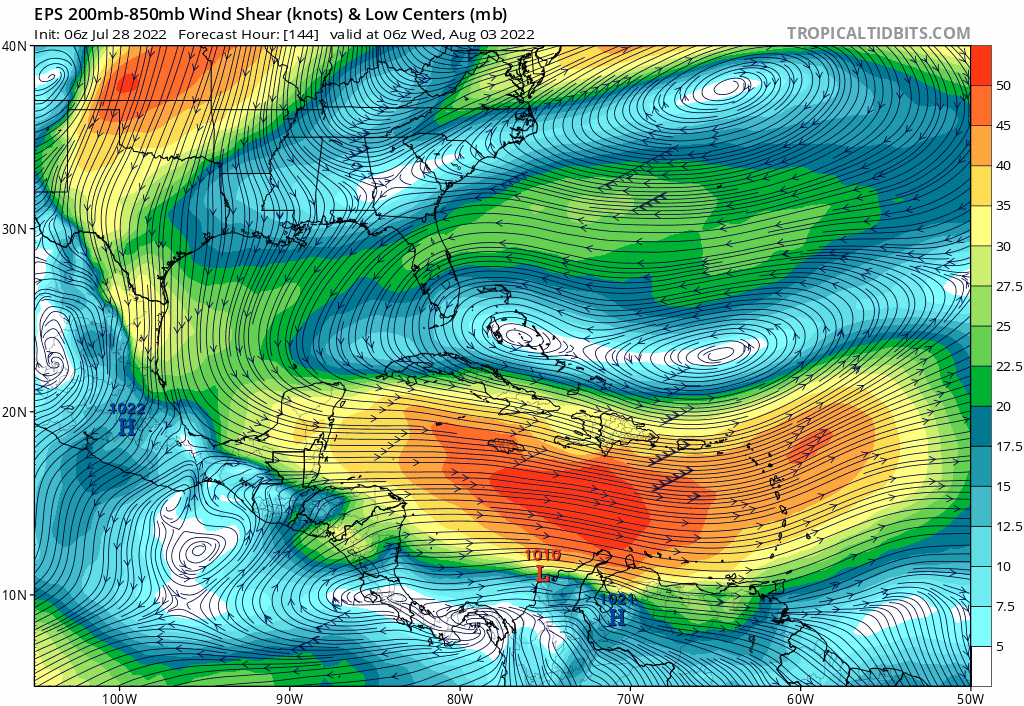
From my amateur experience shear forecasts this time of the year from global models usually go the other way around, they forecast less hostile conditions past their 5-7 day range forecast than what comes to fruition this time of the year. And here is a great example for early next week's shear forecast.

2 likes

Re: 2022 Indicators (SSTs/SAL/MSLP/Shear/Steering/Instability) and >Day 16 Models
NDG wrote:IMHO all I know is that during the next 10-14 days at least the western MDR is going to continue to be shut down with stronger than average shear, this is not the typical La Nina pattern we would see as we head into to August especially since El Nino hasn't been around since 2019.
I just came back from vacationing in Cancun, when I booked this trip back in April I thought that I had made a bad decision, I thought for sure that by late July there was going to be a threat across the Caribbean for tropical development, instead I saw just a couple of tropical showers pass by that rain themselves out from the dry environment which was surprising because there was no dust at all present.
https://i.imgur.com/BnSmUYG.gif
I’d never expect anything in late July regardless of any background state.
3 likes
-
hurricane2025
- Category 1
- Posts: 254
- Joined: Thu Apr 08, 2021 10:36 am
-
hurricane2025
- Category 1
- Posts: 254
- Joined: Thu Apr 08, 2021 10:36 am
Re: 2022 Indicators (SSTs/SAL/MSLP/Shear/Steering/Instability) and >Day 16 Models
hurricane2025 wrote:https://postimg.cc/kDCX35Fs/1b15a482
Euro august to October map
0 likes
-
SFLcane
- S2K Supporter
- Posts: 10281
- Age: 48
- Joined: Sat Jun 05, 2010 1:44 pm
- Location: Lake Worth Florida
Re: 2022 Indicators (SSTs/SAL/MSLP/Shear/Steering/Instability) and >Day 16 Models
Ugly..
You sure la nina is in the epac?
You sure la nina is in the epac?
1 likes
-
skyline385
- Category 5
- Posts: 2728
- Age: 35
- Joined: Wed Aug 26, 2020 11:15 pm
- Location: Houston TX
Re: 2022 Indicators (SSTs/SAL/MSLP/Shear/Steering/Instability) and >Day 16 Models
NDG wrote:Category5Kaiju wrote:NDG wrote:IMHO all I know is that during the next 10-14 days at least the western MDR is going to continue to be shut down with stronger than average shear, this is not the typical La Nina pattern we would see as we head into to August especially since El Nino hasn't been around since 2019.
I just came back from vacationing in Cancun, when I booked this trip back in April I thought that I had made a bad decision, I thought for sure that by late July there was going to be a threat across the Caribbean for tropical development, instead I saw just a couple of tropical showers pass by that rain themselves out from the dry environment which was surprising because there was no dust at all present.
https://i.imgur.com/BnSmUYG.gif
Aren't shear forecasts that go out that far in advance not to be taken at face value though? Shear is very dynamic, and I remember how people were cautioning about how shear forecasts that far out in time can oftentimes not be very reliable in last year's indicators thread
From my amateur experience shear forecasts this time of the year from global models usually go the other way around, they forecast less hostile conditions past their 5-7 day range forecast than what comes to fruition this time of the year. And here is a great example for early next week's shear forecast.
It results from using ensemble means for shear (and other wind-based) forecasts. The different perturbations introduced in the ensemble members to get varying results start to blend in and as a result cancel each other out. One of the options when looking at such forecasts very far out is to use the control member. It won’t be very accurate because it’s just one undisturbed ensemble member but it will be better than the mean. Note that when looking at near term forecasts, means will be the best to use.
1 likes

Re: 2022 Indicators (SSTs/SAL/MSLP/Shear/Steering/Instability) and >Day 16 Models
That's still early August. Nothing unexpected IMO.
2 likes
TC naming lists: retirements and intensity
Most aggressive Advisory #1's in North Atlantic (cr. kevin for starting the list)
Most aggressive Advisory #1's in North Atlantic (cr. kevin for starting the list)
Who is online
Users browsing this forum: Google Adsense [Bot] and 104 guests