Tropical Wave south of the Cabo Verde Islands (Is Invest 97L)
Moderator: S2k Moderators
Forum rules

The posts in this forum are NOT official forecasts and should not be used as such. They are just the opinion of the poster and may or may not be backed by sound meteorological data. They are NOT endorsed by any professional institution or STORM2K. For official information, please refer to products from the National Hurricane Center and National Weather Service.

Re: Tropical Wave to emerge from West Africa tonight
I think the cause for future Danielle’s weakening in the middle Atlantic is due to a TUTT or similar structure. It’s at least a week out, so the position and strength of that shear barrier could change quite a lot. Danielle’s best opportunity to intensify will be in its early few days, when it remains over 27-28C waters while going due west at a very low latitude.
0 likes
Irene '11 Sandy '12 Hermine '16 5/15/2018 Derecho Fay '20 Isaias '20 Elsa '21 Henri '21 Ida '21
I am only a meteorology enthusiast who knows a decent amount about tropical cyclones. Look to the professional mets, the NHC, or your local weather office for the best information.
I am only a meteorology enthusiast who knows a decent amount about tropical cyclones. Look to the professional mets, the NHC, or your local weather office for the best information.
-
cycloneye

- Admin

- Posts: 149712
- Age: 69
- Joined: Thu Oct 10, 2002 10:54 am
- Location: San Juan, Puerto Rico
Re: Tropical Wave to emerge from West Africa tonight
Kingarabian wrote:Looks like a circle soon for the wave exiting Africa soon. GFS has this developing within 72 hours.
It has been circled since 2 AM.
2 likes
Visit the Caribbean-Central America Weather Thread where you can find at first post web cams,radars
and observations from Caribbean basin members Click Here
and observations from Caribbean basin members Click Here
-
cycloneye
- Admin
- Posts: 149712
- Age: 69
- Joined: Thu Oct 10, 2002 10:54 am
- Location: San Juan, Puerto Rico
Re: Tropical Wave to emerge from West Africa tonight


6 likes
Visit the Caribbean-Central America Weather Thread where you can find at first post web cams,radars
and observations from Caribbean basin members Click Here
and observations from Caribbean basin members Click Here
-
MGC

- S2K Supporter

- Posts: 5941
- Joined: Sun Mar 23, 2003 9:05 pm
- Location: Pass Christian MS, or what is left.
Re: Tropical Wave to emerge from West Africa tonight
NHC is getting bullish. Looks like the tropics are waking up right on schedule....MGC
1 likes


Re: Tropical Wave to emerge from West Africa tonight
All the waves that came off Africa earlier dried up traveling west within 20 degrees.
Anchoring Pt 59 off Panama isn't likely to yield much either.

Anchoring Pt 59 off Panama isn't likely to yield much either.
0 likes
-
skyline385

- Category 5

- Posts: 2728
- Age: 35
- Joined: Wed Aug 26, 2020 11:15 pm
- Location: Houston TX

-
InfernoFlameCat

- Category 5
- Posts: 2127
- Age: 22
- Joined: Mon Dec 14, 2020 10:52 am
- Location: Buford, GA
Re: Tropical Wave to emerge from West Africa tonight
cycloneye wrote:Kingarabian wrote:Looks like a circle soon for the wave exiting Africa soon. GFS has this developing within 72 hours.
It has been circled since 2 AM.
I think he means a tropical depression circle.
2 likes
I am by no means a professional. DO NOT look at my forecasts for official information or make decisions based on what I post.
Goal: to become a registered expert over tropical and subtropical cyclones.
Goal: to become a registered expert over tropical and subtropical cyclones.
-
DorkyMcDorkface

- Category 5
- Posts: 1043
- Age: 28
- Joined: Mon Sep 30, 2019 1:32 pm
- Location: Mid-Atlantic
Re: Tropical Wave to emerge from West Africa tonight
Now that the wave is emerging we can try to compare and contrast what the GFS and Euro have roughly around this time. How much convective activity persists will determine whether or not this thing could spin up as quickly as the GFS or take its time like the Euro. Presently it appears the GFS has the edge - we'll see how things progress into the morning.


(I apologize for the lack of zoom on the Euro)
(I apologize for the lack of zoom on the Euro)
2 likes
Please note the thoughts expressed by this account are solely those of the user and are from a hobbyist perspective. For more comprehensive analysis, consult an actual professional meteorologist or meteorological agency.
Floyd 1999 | Isabel 2003 | Hanna 2008 | Irene 2011 | Sandy 2012 | Isaias 2020
-
AtlanticWind
- S2K Supporter
- Posts: 1898
- Age: 67
- Joined: Sun Aug 08, 2004 9:57 pm
- Location: Plantation,Fla
-
cycloneye
- Admin
- Posts: 149712
- Age: 69
- Joined: Thu Oct 10, 2002 10:54 am
- Location: San Juan, Puerto Rico
Re: Tropical Wave off the African Coast


1 likes
Visit the Caribbean-Central America Weather Thread where you can find at first post web cams,radars
and observations from Caribbean basin members Click Here
and observations from Caribbean basin members Click Here
-
skyline385
- Category 5
- Posts: 2728
- Age: 35
- Joined: Wed Aug 26, 2020 11:15 pm
- Location: Houston TX
Re: Tropical Wave off the African Coast
Almost nothing on EPS that would be quiet a big bust if it verified.

Last edited by skyline385 on Sun Aug 07, 2022 10:30 am, edited 1 time in total.
1 likes
-
MHC Tracking
- Tropical Storm

- Posts: 203
- Joined: Mon Mar 15, 2021 10:05 am
Re: Tropical Wave off the African Coast
skyline385 wrote:Almost nothing on EPS that would be quiet a big bust if it verifiedhttps://uploads.tapatalk-cdn.com/20220807/19d38f29e9139b7be58a448e723d6775.jpg
Sent from my LM-V405 using Tapatalk
Not sure what to trust here, GFS has been its typical bullish self with this, yet EPS has now strayed away from its apparent MDR bias. i would just attribute this to a post splashdown "snap" back to reality, yet GFS hasn't dropped it yet. Very uncertain future for this wave
0 likes
-
skyline385
- Category 5
- Posts: 2728
- Age: 35
- Joined: Wed Aug 26, 2020 11:15 pm
- Location: Houston TX
Re: Tropical Wave off the African Coast
Looks like ICON and CMC have backed off as well.MHC Tracking wrote:skyline385 wrote:Almost nothing on EPS that would be quiet a big bust if it verifiedhttps://uploads.tapatalk-cdn.com/20220807/19d38f29e9139b7be58a448e723d6775.jpg
Sent from my LM-V405 using Tapatalk
Not sure what to trust here, GFS has been its typical bullish self with this, yet EPS has now strayed away from its apparent MDR bias. i would just attribute this to a post splashdown "snap" back to reality, yet GFS hasn't dropped it yet. Very uncertain future for this wave
Sent from my LM-V405 using Tapatalk
1 likes
-
cycloneye
- Admin
- Posts: 149712
- Age: 69
- Joined: Thu Oct 10, 2002 10:54 am
- Location: San Juan, Puerto Rico
Re: Tropical Wave off the African Coast
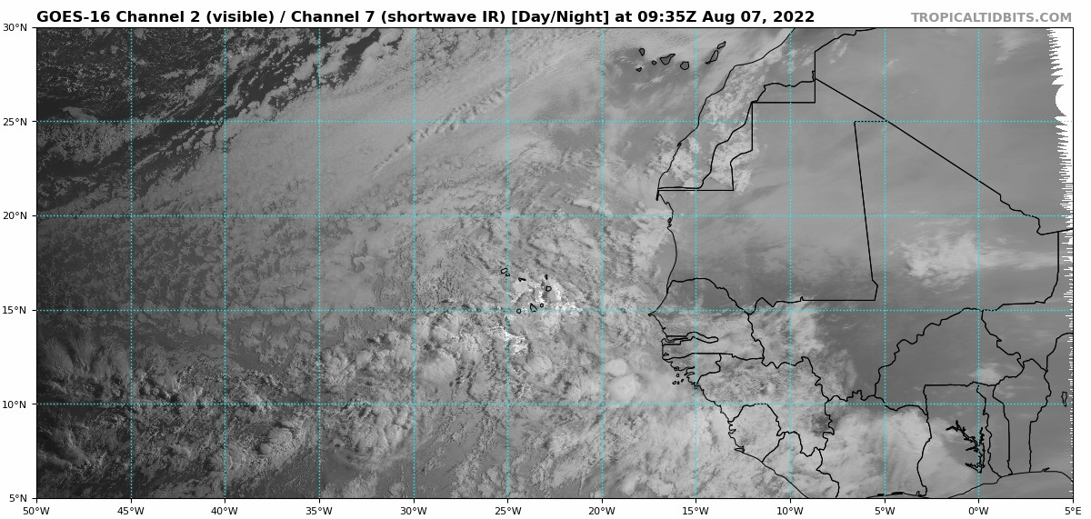
12:05 UTC discussion:
A far eastern Atlantic tropical has partially emerged offshore
Africa. It has its axis along 16W from 05N to 20N. It is moving
westward at about 10 kt. Satellite imagery shows clusters of
scattered moderate to isolated strong convection mainly ahead
of the wave from 08N to 13N between the coast of Africa and 21W.
Africa. It has its axis along 16W from 05N to 20N. It is moving
westward at about 10 kt. Satellite imagery shows clusters of
scattered moderate to isolated strong convection mainly ahead
of the wave from 08N to 13N between the coast of Africa and 21W.
0 likes
Visit the Caribbean-Central America Weather Thread where you can find at first post web cams,radars
and observations from Caribbean basin members Click Here
and observations from Caribbean basin members Click Here
-
MHC Tracking
- Tropical Storm
- Posts: 203
- Joined: Mon Mar 15, 2021 10:05 am
Re: Tropical Wave off the African Coast
skyline385 wrote:Looks like ICON and CMC have backed off as well.MHC Tracking wrote:skyline385 wrote:Almost nothing on EPS that would be quiet a big bust if it verifiedhttps://uploads.tapatalk-cdn.com/20220807/19d38f29e9139b7be58a448e723d6775.jpg
Sent from my LM-V405 using Tapatalk
Not sure what to trust here, GFS has been its typical bullish self with this, yet EPS has now strayed away from its apparent MDR bias. i would just attribute this to a post splashdown "snap" back to reality, yet GFS hasn't dropped it yet. Very uncertain future for this wave
Sent from my LM-V405 using Tapatalk
ECMWF seems to have potentially underinitialized vorticity, looking at real-time convective trends compared to both that and the GFS.


0 likes
-
MHC Tracking
- Tropical Storm
- Posts: 203
- Joined: Mon Mar 15, 2021 10:05 am
Re: Tropical Wave off the African Coast
skyline385 wrote:MHC Tracking wrote:skyline385 wrote:Looks like ICON and CMC have backed off as well.
Sent from my LM-V405 using Tapatalk
ECMWF seems to have potentially underinitialized vorticity, looking at real-time convective trends compared to both that and the GFS.
https://cdn.discordapp.com/attachments/903995026214879262/1005799062395686962/gfs_vort850_uv200_eatl_1.png
https://cdn.discordapp.com/attachments/903995026214879262/1005799062118879262/ecmwf_vort850_uv200_eatl_3.png
https://cdn.discordapp.com/attachments/903995026214879262/1005800078038007910/GOES16_1km_ir_202208071115_3.75_20.25_-32.00_-6.00_ir1_ltngge_hgwy_warn_latlon_weathernerds.png
It is possible but looking at CIMMS, it seems the GFS is overdoing the vorticity as well.
https://uploads.tapatalk-cdn.com/20220807/acf3dbf9626d0eaeadccb2b10bba8218.gif
Sent from my iPhone using Tapatalk
Assuming the two products use the same scale, both seem to show relative cyclonic vorticity in the 20s - CIMSS just uses a different colortable.
2 likes
-
cycloneye
- Admin
- Posts: 149712
- Age: 69
- Joined: Thu Oct 10, 2002 10:54 am
- Location: San Juan, Puerto Rico
Re: Tropical Wave off the African Coast
Tropical Weather Outlook
NWS National Hurricane Center Miami FL
800 AM EDT Sun Aug 7 2022
For the North Atlantic...Caribbean Sea and the Gulf of Mexico:
Eastern Tropical Atlantic:
A tropical wave located just off the west coast of Africa is
producing disorganized showers and thunderstorms over the far
eastern tropical Atlantic. Environmental conditions appear generally
conducive for gradual development of this system while it moves
westward to west-northwestward at 15 to 20 mph across the eastern
and central tropical Atlantic, and a tropical depression could form
around the middle part of this week.
* Formation chance through 48 hours...low...near 0 percent.
* Formation chance through 5 days...medium...40 percent.
$$
Forecaster Papin

0 likes
Visit the Caribbean-Central America Weather Thread where you can find at first post web cams,radars
and observations from Caribbean basin members Click Here
and observations from Caribbean basin members Click Here
-
gatorcane

- S2K Supporter
- Posts: 23708
- Age: 48
- Joined: Sun Mar 13, 2005 3:54 pm
- Location: Boca Raton, FL
Re: Tropical Wave off the African Coast
Looking at how the GFS is doing with this wave so far and how the wave looks this morning, maybe it is the now the CMC of old (which developed everything). Seems the GFS might be over-zealous on development this time again. The CMC never really did develop this and so far that might be closer to reality. Even the Euro has backed off.
1 likes
-
Spacecoast

- Category 2

- Posts: 773
- Joined: Thu Aug 31, 2017 2:03 pm

Who is online
Users browsing this forum: Ed_2001, Google Adsense [Bot], pepecool20 and 249 guests