ATL: Ex INVEST 98L - Discussion
Moderator: S2k Moderators

Re: ATL: INVEST 98L - Discussion
Like I said if only 12-24 more hours over water. Look at that presentation..  sweet
sweet
1 likes
-
Craters
- Category 1

- Posts: 428
- Joined: Sat Aug 24, 2013 2:34 pm
- Location: Alvin, TX (south of Houston)
Re: ATL: INVEST 98L - Discussion
Hey, Soupbone -- did any of those outer rain bands make their way up to you yet?? We got at least a little wet here in Brazoria County, and it looks like there's still a little bit more on the way before 98L moves out.
1 likes
Nothing that I post here should ever be treated as a forecast or anything resembling one. Please check with your local NWS office or the NHC for forecasts, watches, and warnings.
-
vbhoutex

- Storm2k Executive

- Posts: 29146
- Age: 74
- Joined: Wed Oct 09, 2002 11:31 pm
- Location: Cypress, TX
- Contact:
Re: ATL: INVEST 98L - Discussion
Craters wrote:Hey, Soupbone -- did any of those outer rain bands make their way up to you yet?? We got at least a little wet here in Brazoria County, and it looks like there's still a little bit more on the way before 98L moves out.
I'm not soupbone, but sun is shining bright in Spring Branch area in W. Houston.

3 likes
Skywarn, C.E.R.T.
Please click below to donate to STORM2K to help with the expenses of keeping the site going:

Please click below to donate to STORM2K to help with the expenses of keeping the site going:
-
lrak

- S2K Supporter

- Posts: 1770
- Age: 59
- Joined: Thu Jun 21, 2007 2:48 pm
- Location: Corpus Christi, TX
Re: ATL: INVEST 98L - Discussion
Steve wrote:lrak wrote:So thankful for the rain...Yes!
We've only had a 1/10 th so far here in CCTX, but a lot of potential remains, keeping fingers crossed.
Happier now?
Very happy
3 likes
AKA karl
Also
Personal Forecast Disclaimer:
My posts on this forum are NOT official forecast and should not be used as such. My posts are my basic observations and are definitely not backed by any "well some" meteorological knowledge. For official information, please refer to the NHC and NWS products.
Also
Personal Forecast Disclaimer:
My posts on this forum are NOT official forecast and should not be used as such. My posts are my basic observations and are definitely not backed by any "well some" meteorological knowledge. For official information, please refer to the NHC and NWS products.
Re: ATL: INVEST 98L - Discussion
vbhoutex wrote:Craters wrote:Hey, Soupbone -- did any of those outer rain bands make their way up to you yet?? We got at least a little wet here in Brazoria County, and it looks like there's still a little bit more on the way before 98L moves out.
I'm not soupbone, but sun is shining bright in Spring Branch area in W. Houston.What's rain?
Might get a sprinkle up in W Houston.
1 likes


-
Kingarabian

- S2K Supporter
- Posts: 16350
- Joined: Sat Aug 08, 2009 3:06 am
- Location: Honolulu, Hawaii
Re: ATL: INVEST 98L - Discussion
I am genuinely curious if the NHC will classify this in the off season.
4 likes
RIP Kobe Bryant

Re: ATL: INVEST 98L - Discussion
Kingarabian wrote:I am genuinely curious if the NHC will classify this in the off season.
Corpus recorded a surface pressure of 1009.4 mb's recently but that was after landfall.
There is a forecast wave with a 1010 mb dip passing over Barbados late next week.
4 likes

Re: ATL: INVEST 98L - Discussion
NDG wrote:Best looking system of the season so far, and is over land
https://i.imgur.com/glfyHII.gif
Yeah. Seemed like a decent possibility from yesterday and Friday and got pointed out as something to look for. Could bring a lot more localized rain than the models were showing.
0 likes

Re: ATL: INVEST 98L - Discussion
Into my unclassified depression/storm archive it goes!
And what is with Texas in particular where storms seem to organize quickly after moving inland? We had a couple back to back storms in June a few years ago, and several in June/July 1998 (and many others over the years) and several tropical storms have made landfall and looked significantly better organized inland vs over water.
And what is with Texas in particular where storms seem to organize quickly after moving inland? We had a couple back to back storms in June a few years ago, and several in June/July 1998 (and many others over the years) and several tropical storms have made landfall and looked significantly better organized inland vs over water.
5 likes
The above post is not official and should not be used as such. It is the opinion of the poster and may or may not be backed by sound meteorological data. It is not endorsed by any professional institution or storm2k.org. For official information, please refer to the NHC and NWS products.
-
Iceresistance

- Category 5

- Posts: 9579
- Age: 22
- Joined: Sat Oct 10, 2020 9:45 am
- Location: Tecumseh, OK/Norman, OK
Re: ATL: INVEST 98L - Discussion
Hammy wrote:Into my unclassified depression/storm archive it goes!
And what is with Texas in particular where storms seem to organize quickly after moving inland? We had a couple back to back storms in June a few years ago, and several in June/July 1998 (and many others over the years) and several tropical storms have made landfall and looked significantly better organized inland vs over water.
Port Aransas reported gale-force wind gusts near the CoC.
https://twitter.com/BigJoeBastardi/status/1558843250332512257
2 likes
Bill 2015 & Beta 2020
Winter 2020-2021
All observations are in Tecumseh, OK unless otherwise noted.
Winter posts are focused mainly for Oklahoma & Texas.
Take any of my forecasts with a grain of salt, refer to the NWS, SPC, and NHC for official information
Never say Never with weather! Because ANYTHING is possible!
Winter 2020-2021
All observations are in Tecumseh, OK unless otherwise noted.
Winter posts are focused mainly for Oklahoma & Texas.
Take any of my forecasts with a grain of salt, refer to the NWS, SPC, and NHC for official information
Never say Never with weather! Because ANYTHING is possible!
-
Sciencerocks
- Category 5
- Posts: 10181
- Age: 40
- Joined: Thu Jul 06, 2017 1:51 am
Re: ATL: INVEST 98L - Discussion
I believe this was probably a td...  We'll see about post seasons but I don't know if the nhc upgrades invest to depression post season.
1 likes
-
Kingarabian
- S2K Supporter
- Posts: 16350
- Joined: Sat Aug 08, 2009 3:06 am
- Location: Honolulu, Hawaii
Re: ATL: INVEST 98L - Discussion
Its landfalling behavior is very similar to previous TC's. Just depends if the NHC has the criteria available to do a post season analysis. Either way the risk of this system was the same whether it was classified a TC or not.
0 likes
RIP Kobe Bryant
Re: ATL: INVEST 98L - Discussion
Kingarabian wrote:Its landfalling behavior is very similar to previous TC's. Just depends if the NHC has the criteria available to do a post season analysis. Either way the risk of this system was the same whether it was classified a TC or not.
They put up watches and warning boxes for the thunderstorms and squall winds.
A C130 uses about 300 LBS of fuel an hour to fly over a storm and set dropsondes.
Besides that its Sunday, the cows in Texas are happy and we need the resources for September analysis.
1 likes
-
tolakram
- Admin
- Posts: 20179
- Age: 62
- Joined: Sun Aug 27, 2006 8:23 pm
- Location: Florence, KY (name is Mark)
Re: ATL: INVEST 98L - Discussion
3 likes
M a r k
- - - - -
Join us in chat: Storm2K Chatroom Invite. Android and IOS apps also available.
The posts in this forum are NOT official forecasts and should not be used as such. Posts are NOT endorsed by any professional institution or STORM2K.org. For official information and forecasts, please refer to NHC and NWS products.
-
Iceresistance
- Category 5
- Posts: 9579
- Age: 22
- Joined: Sat Oct 10, 2020 9:45 am
- Location: Tecumseh, OK/Norman, OK
Re: ATL: Ex INVEST 98L - Discussion
Lots of Flooding rainfall in Southern Texas right now.
1 likes
Bill 2015 & Beta 2020
Winter 2020-2021
All observations are in Tecumseh, OK unless otherwise noted.
Winter posts are focused mainly for Oklahoma & Texas.
Take any of my forecasts with a grain of salt, refer to the NWS, SPC, and NHC for official information
Never say Never with weather! Because ANYTHING is possible!
Winter 2020-2021
All observations are in Tecumseh, OK unless otherwise noted.
Winter posts are focused mainly for Oklahoma & Texas.
Take any of my forecasts with a grain of salt, refer to the NWS, SPC, and NHC for official information
Never say Never with weather! Because ANYTHING is possible!
-
InfernoFlameCat

- Category 5
- Posts: 2127
- Age: 22
- Joined: Mon Dec 14, 2020 10:52 am
- Location: Buford, GA
Re: ATL: Ex INVEST 98L - Discussion
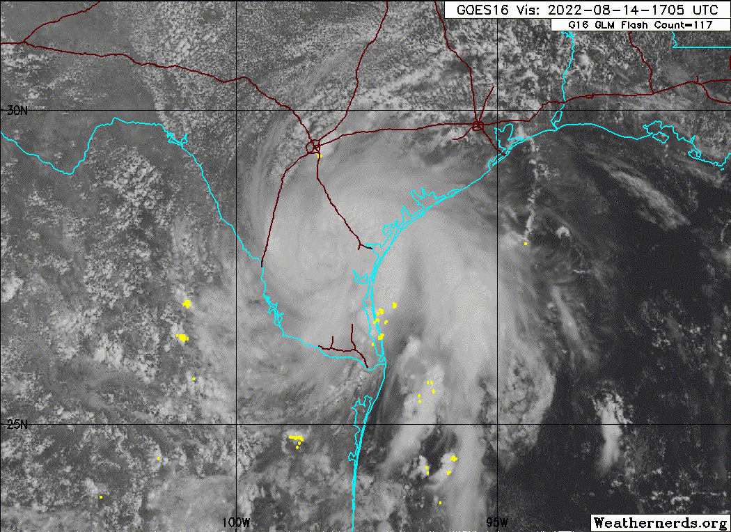
System is still presentable 23-24 hours after landfall.
0 likes
I am by no means a professional. DO NOT look at my forecasts for official information or make decisions based on what I post.
Goal: to become a registered expert over tropical and subtropical cyclones.
Goal: to become a registered expert over tropical and subtropical cyclones.
-
Edwards Limestone

- S2K Supporter
- Posts: 509
- Age: 36
- Joined: Tue Dec 28, 2021 11:05 am
- Location: Smithson Valley, TX
Re: ATL: Ex INVEST 98L - Discussion
Iceresistance wrote:Lots of Flooding rainfall in Southern Texas right now.
Too bad it's not further north/updip in the Hill Country. We are bone dry.
The shear associated w/ the death ridge is very evident even on radar. Of course, this is the one storm where the north/east side aren't favored

0 likes
The above post is NOT an official forecast and should not be used as such. It is just the opinion of the poster and may or may not be backed by sound meteorological data. It is NOT endorsed by any professional institution including Storm2k. For official information, please refer to NWS products.
-
somethingfunny

- ChatStaff

- Posts: 3926
- Age: 37
- Joined: Thu May 31, 2007 10:30 pm
- Location: McKinney, Texas
Re: ATL: INVEST 98L - Discussion
Hammy wrote:
And what is with Texas in particular where storms seem to organize quickly after moving inland? We had a couple back to back storms in June a few years ago, and several in June/July 1998 (and many others over the years) and several tropical storms have made landfall and looked significantly better organized inland vs over water.
It has something to do with the shape of the western GOM coastline and perhaps the inland topography, westward-moving systems tend to wrap up into nice-looking compact round presentational right as they reach the coastline. You'd expect dry air from the Sierra Oriental and from central Texas to contribute more interference yet it doesn't seem to happen that way. I'd love to see research on the subject.
4 likes
I am not a meteorologist, and any posts made by me are not official forecasts or to be interpreted as being intelligent. These posts are just my opinions and are probably silly opinions.
-
cycloneye

- Admin
- Posts: 149292
- Age: 69
- Joined: Thu Oct 10, 2002 10:54 am
- Location: San Juan, Puerto Rico
Re: ATL: Ex INVEST 98L - Discussion
0 likes
Visit the Caribbean-Central America Weather Thread where you can find at first post web cams,radars
and observations from Caribbean basin members Click Here
and observations from Caribbean basin members Click Here
Who is online
Users browsing this forum: No registered users and 6 guests