Tropical Wave west of the Cabo Verde Islands (Is Invest 90L)
Moderator: S2k Moderators
Forum rules

The posts in this forum are NOT official forecasts and should not be used as such. They are just the opinion of the poster and may or may not be backed by sound meteorological data. They are NOT endorsed by any professional institution or STORM2K. For official information, please refer to products from the National Hurricane Center and National Weather Service.
Re: Tropical Wave off the African Coast (22W)
The 18z is going to give us the "not running into Hispaniola" scenario for the lead wave
3 likes
-
ElectricStorm

- Category 5

- Posts: 5155
- Age: 25
- Joined: Tue Aug 13, 2019 11:23 pm
- Location: Norman, OK
Re: Tropical Wave off the African Coast (22W)
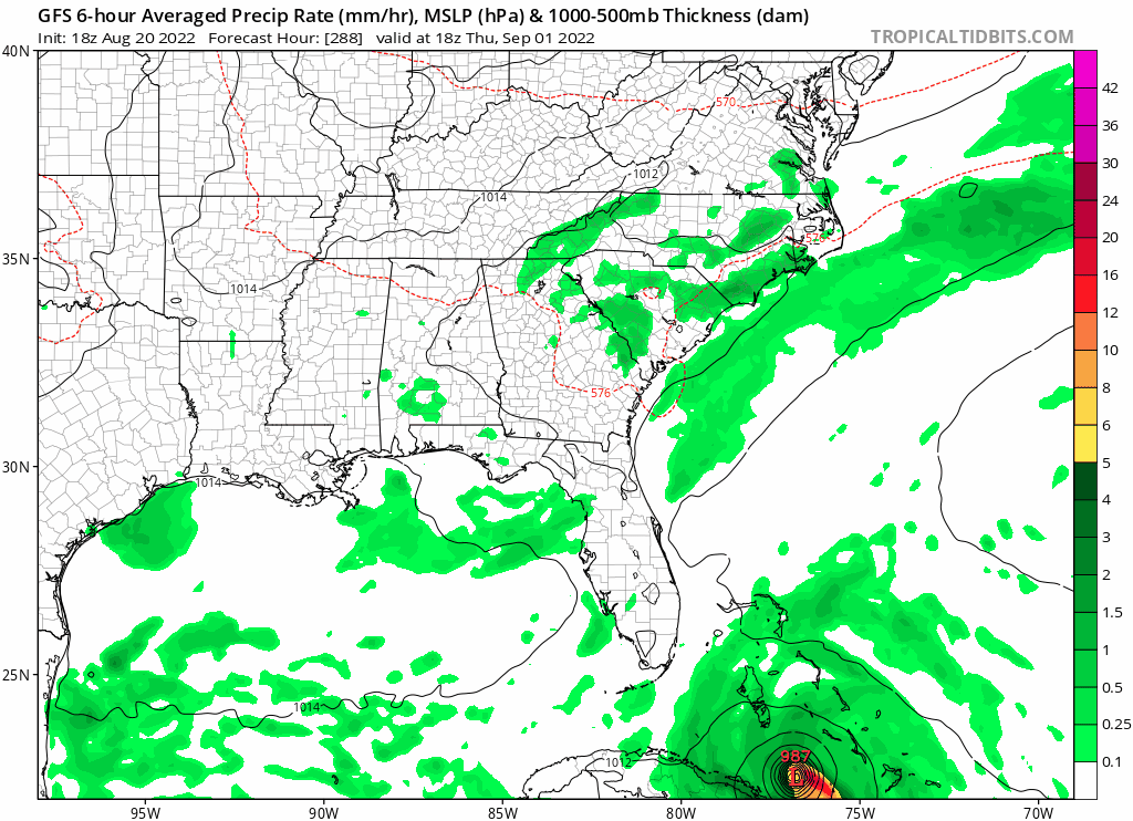
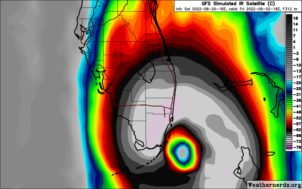
18z GFS has this just barely staying north of Hispaniola and becoming a hurricane near Cuba
0 likes
B.S Meteorology, University of Oklahoma '25
Please refer to the NHC, NWS, or SPC for official information.
Please refer to the NHC, NWS, or SPC for official information.
-
Blown Away

- S2K Supporter

- Posts: 10253
- Joined: Wed May 26, 2004 6:17 am
Re: Tropical Wave off the African Coast (22W)
1 likes
Hurricane Eye Experience: David 79, Irene 99, Frances 04, Jeanne 04, Wilma 05… Hurricane Brush Experience: Andrew 92, Erin 95, Floyd 99, Matthew 16, Irma 17, Ian 22, Nicole 22…
-
jlauderdal
- S2K Supporter
- Posts: 7240
- Joined: Wed May 19, 2004 5:46 am
- Location: NE Fort Lauderdale
- Contact:
Re: Tropical Wave off the African Coast (22W)
Sofla has been nailed twice today on seperate runsBlown Away wrote::eek: 18z GFS has first TW into Cat 2/3 heading for SFL.
1 likes
-
ElectricStorm
- Category 5
- Posts: 5155
- Age: 25
- Joined: Tue Aug 13, 2019 11:23 pm
- Location: Norman, OK
Re: Tropical Wave off the African Coast (22W)
Direct hit for SFL at 964mb this run...
0 likes
B.S Meteorology, University of Oklahoma '25
Please refer to the NHC, NWS, or SPC for official information.
Please refer to the NHC, NWS, or SPC for official information.
-
skyline385

- Category 5
- Posts: 2728
- Age: 35
- Joined: Wed Aug 26, 2020 11:15 pm
- Location: Houston TX

Re: Tropical Wave off the African Coast (22W)
Typical mid-season tease from the GFS. The dreaded turn, directly up 80W
1 likes
-
Blown Away
- S2K Supporter
- Posts: 10253
- Joined: Wed May 26, 2004 6:17 am
Re: Tropical Wave off the African Coast (22W)
jlauderdal wrote:Sofla has been nailed twice today on seperate runsBlown Away wrote::eek: 18z GFS has first TW into Cat 2/3 heading for SFL.
Fire up the generator!
1 likes
Hurricane Eye Experience: David 79, Irene 99, Frances 04, Jeanne 04, Wilma 05… Hurricane Brush Experience: Andrew 92, Erin 95, Floyd 99, Matthew 16, Irma 17, Ian 22, Nicole 22…
Re: Tropical Wave off the African Coast (22W)
I suppose the model will finish with the ridge expanding, sending the system into the Gulf, and allowing the trailing Hurricane to turn back west
1 likes
-
jlauderdal
- S2K Supporter
- Posts: 7240
- Joined: Wed May 19, 2004 5:46 am
- Location: NE Fort Lauderdale
- Contact:
Re: RE: Re: RE: Re: Tropical Wave off the African Coast (22W)
Its ready, I have a new invertor generator ready to go. The Wilma generator has been sold.Blown Away wrote::Djlauderdal wrote:Sofla has been nailed twice today on seperate runsBlown Away wrote::eek: 18z GFS has first TW into Cat 2/3 heading for SFL.
Fire up the generator!
3 likes
-
AnnularCane

- S2K Supporter
- Posts: 2964
- Joined: Thu Jun 08, 2006 9:18 am
- Location: Wytheville, VA
Re: Tropical Wave off the African Coast (22W)
It's not hurricane season until you get the first long-range model of a major into Miami. 
6 likes
"But it never rained rain. It never snowed snow. And it never blew just wind. It rained things like soup and juice. It snowed mashed potatoes and green peas. And sometimes the wind blew in storms of hamburgers." -- Judi Barrett, Cloudy with a Chance of Meatballs
-
cycloneye

- Admin

- Posts: 149716
- Age: 69
- Joined: Thu Oct 10, 2002 10:54 am
- Location: San Juan, Puerto Rico
Re: Tropical Wave off the African Coast (22W)
Eastern Tropical Atlantic:
A tropical wave located near the west coast of Africa is producing
disorganized showers and thunderstorms. Environmental conditions
are expected to be marginally conducive for gradual development of
this system while it moves westward to west-northwestward at 15
to 20 mph across the eastern and central tropical Atlantic during
the early to middle part of next week.
* Formation chance through 48 hours...low...near 0 percent.
* Formation chance through 5 days...low...20 percent.

1 likes
Visit the Caribbean-Central America Weather Thread where you can find at first post web cams,radars
and observations from Caribbean basin members Click Here
and observations from Caribbean basin members Click Here
-
cycloneye
- Admin
- Posts: 149716
- Age: 69
- Joined: Thu Oct 10, 2002 10:54 am
- Location: San Juan, Puerto Rico
Re: Tropical Wave off the African Coast (21W)
00:05 UTC discussion.
A tropical wave located near the west coast of Africa along 21W
is producing disorganized showers and thunderstorms from 10N to
17N between 17W and 25W. A 1008 mb low pressure is analyzed along
the wave axis near 15N. Environmental conditions are expected to
be marginally conducive for gradual development of this system
while it moves westward to west-northwestward at 15 to 20 mph
across the eastern and central tropical Atlantic during the early
to middle part of next week. Currently, this tropical wave has a
low chance of tropical cyclone development over the next five
days.
0 likes
Visit the Caribbean-Central America Weather Thread where you can find at first post web cams,radars
and observations from Caribbean basin members Click Here
and observations from Caribbean basin members Click Here
-
SFLcane

- S2K Supporter
- Posts: 10281
- Age: 48
- Joined: Sat Jun 05, 2010 1:44 pm
- Location: Lake Worth Florida
2022 Global Model Runs Discussion (Out thru day 16)
Northern quadrant into Dade and Broward. 
3 likes
-
Iceresistance

- Category 5
- Posts: 9606
- Age: 22
- Joined: Sat Oct 10, 2020 9:45 am
- Location: Tecumseh, OK/Norman, OK
Re: 2022 Global Model Runs Discussion (Out thru day 16)
SFLcane wrote:Northern quadrant into Dade and Broward.
https://i.postimg.cc/4d9bsq1s/7-AE65-D4-D-D8-E8-4721-9680-F73-E18-FB883-F.png
This would be catastrophic disaster for Southern Florida if it really happened like this.
2 likes
Bill 2015 & Beta 2020
Winter 2020-2021
All observations are in Tecumseh, OK unless otherwise noted.
Winter posts are focused mainly for Oklahoma & Texas.
Take any of my forecasts with a grain of salt, refer to the NWS, SPC, and NHC for official information
Never say Never with weather! Because ANYTHING is possible!
Winter 2020-2021
All observations are in Tecumseh, OK unless otherwise noted.
Winter posts are focused mainly for Oklahoma & Texas.
Take any of my forecasts with a grain of salt, refer to the NWS, SPC, and NHC for official information
Never say Never with weather! Because ANYTHING is possible!
-
cycloneye
- Admin
- Posts: 149716
- Age: 69
- Joined: Thu Oct 10, 2002 10:54 am
- Location: San Juan, Puerto Rico
Re: Tropical Wave off the African Coast (21W)
Interesting that some barbs are showing different directions.

5 likes
Visit the Caribbean-Central America Weather Thread where you can find at first post web cams,radars
and observations from Caribbean basin members Click Here
and observations from Caribbean basin members Click Here
-
Hybridstorm_November2001

- S2K Supporter
- Posts: 2817
- Joined: Sat Aug 21, 2004 2:50 pm
- Location: SW New Brunswick, Canada
- Contact:
Re: Tropical Wave off the African Coast (22W)
AnnularCane wrote:It's not hurricane season until you get the first long-range model of a major into Miami.
or NYC
5 likes
Re: Tropical Wave off the African Coast (21W)
cycloneye wrote:Interesting that some barbs are showing different directions.
https://i.imgur.com/cYGJe9I.jpg
Satellite pics showing cloud curvature make it appear to me there's likely a weak circulation (surface?) near the CVs. And models like the 18Z GFS have a weak low there now:

The GFS maintains a weak but rather tight circulation and at times even strengthens it some from here all of the way across as it moves WNW, then W, then WSW within the E and C MDR. But the Euro, which has an even weaker and broader circulation, doesn't maintain it for too long.
The next couple of days of satellite pics will be quite interesting to follow to see what happens. We will probably continue to see cloud curvature. However, right now most seem to feel that it it too dry/stable in the E Atlantic for this to develop and that development would have to wait til it gets past 55W or so. Then again, models have been fooled many times.
0 likes
Personal Forecast Disclaimer:
The posts in this forum are NOT official forecasts and should not be used as such. They are just the opinion of the poster and may or may not be backed by sound meteorological data. They are NOT endorsed by any professional institution or storm2k.org. For official information, please refer to the NHC and NWS products.
The posts in this forum are NOT official forecasts and should not be used as such. They are just the opinion of the poster and may or may not be backed by sound meteorological data. They are NOT endorsed by any professional institution or storm2k.org. For official information, please refer to the NHC and NWS products.
-
cycloneye
- Admin
- Posts: 149716
- Age: 69
- Joined: Thu Oct 10, 2002 10:54 am
- Location: San Juan, Puerto Rico
Re: Tropical Wave off the African Coast (23W)
The 00z surface analysis has the wave axis at 23W.

0 likes
Visit the Caribbean-Central America Weather Thread where you can find at first post web cams,radars
and observations from Caribbean basin members Click Here
and observations from Caribbean basin members Click Here
Re: Tropical Wave off the African Coast (23W)
How's the SAL there now?
0 likes
Personal Forecast Disclaimer:
The posts in this forum are NOT official forecasts and should not be used as such. They are just the opinion of the poster and may or may not be backed by sound meteorological data. They are NOT endorsed by any professional institution or storm2k.org. For official information, please refer to the NHC and NWS products.
The posts in this forum are NOT official forecasts and should not be used as such. They are just the opinion of the poster and may or may not be backed by sound meteorological data. They are NOT endorsed by any professional institution or storm2k.org. For official information, please refer to the NHC and NWS products.
Who is online
Users browsing this forum: pepecool20 and 230 guests