Full 18z GFS…
Moderator: S2k Moderators


Blown Away wrote:[url]https://i.postimg.cc/Y9pvRfHD/gfs-mslp-pcpn-watl-fh276-384.gif [/url]
18z GFS is a keeper! Miami, New Orleans, and likely Carolinas all get a major hurricane within a week!


SFLcane wrote:The long range steering i am seeing Is worrisome on the gfs.

AJC3 wrote:SFLcane wrote:The long range steering i am seeing Is worrisome on the gfs.
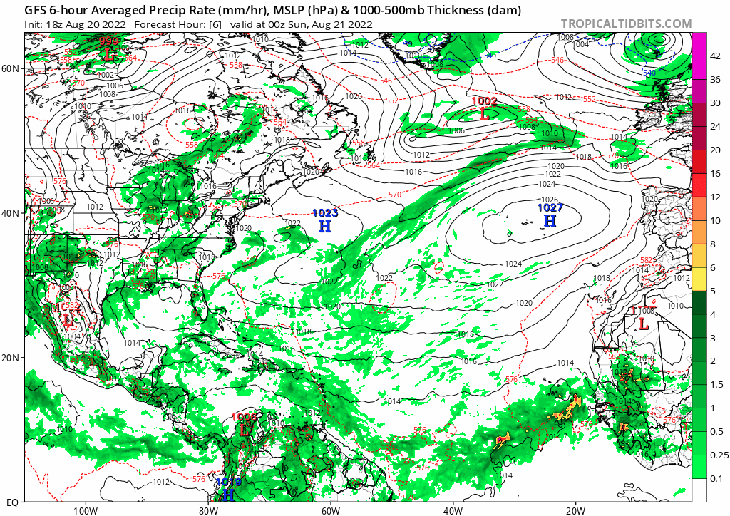
Indeed. Assuming one or both of the waves being talked about pass through (or near) the northern portion of the eastern Hebert Box (with a couple degrees of 20N60W), that ridge to the north looks pretty solid all the way to at least 85W in the Day 6-10 range. Of course, a lot can change between now and then...we'll see if any signs of a weakness developing show up in the models over the next week or so.
gatorcane wrote:AJC3 wrote:SFLcane wrote:The long range steering i am seeing Is worrisome on the gfs.
Indeed. Assuming one or both of the waves being talked about pass through (or near) the northern portion of the eastern Hebert Box (with a couple degrees of 20N60W), that ridge to the north looks pretty solid all the way to at least 85W in the Day 6-10 range. Of course, a lot can change between now and then...we'll see if any signs of a weakness developing show up in the models over the next week or so.
It looks solid but just towards the end of the 6-10 day range, today’s global model runs are showing a break in the ridge over the Central Atlantic between the Bermuda High and Azores High
The most likely scenario as far as the two GFS systems is the current wave the NHC is highlighting (the one the 18Z hits South Florida in the eternity range) will not develop possibly staying weak and/or getting absorbed by the east wave while the second wave develops and possibly recurves into the Central Atlantic kindaof like what the 12Z Euro is hinting at but maybe recurving a bit further west than the Euro shows.
Yep....this is why i prefaced my comment with "as long as something can get to near 20N60W..." , since it would be well past the central Atlantic breach in the 500MB ridge. Once a system would get to about 55W, it wouldn't get drawn northward, since northerly mid level flow on the eastern flank of the ridge would prevent that from taking place (In fact, it could actually cause a system in that area to lose a few tenths of latitude). Otherwise, you'd need a trough to develop between 60 and 80W in order to pick a system up, which there's no sign of at the moment.


Category5Kaiju wrote:Looks like we've got yet another case of bipolar model swinging going on now, with models trying to adjust to what should be changing conditions in the Atlantic toward a more favorable state. Popcorn ready, I am willing to bet that if the 0z GFS shows nothing that the 6z GFS will show a major Miami strike


Users browsing this forum: mixedDanilo.E and 312 guests


