2022 Global Model Runs Discussion (Out thru day 16)

This is the general tropical discussion area. Anyone can take their shot at predicting a storms path.

Moderator: S2k Moderators

Forum rules

The posts in this forum are NOT official forecasts and should not be used as such. They are just the opinion of the poster and may or may not be backed by sound meteorological data. They are NOT endorsed by any professional institution or STORM2K. For official information, please refer to products from the National Hurricane Center and National Weather Service.

Help Support Storm2K
Message
Author
MarioProtVI
Category 4
Category 4
Posts: 935
Age: 24
Joined: Sun Sep 29, 2019 7:33 pm
Location: New Jersey

Re: 2022 Global Model Runs Discussion (Out thru day 16)

#1761 Postby MarioProtVI » Sun Aug 21, 2022 1:03 am

Hammy wrote:Looks like the models are adjusting to possibly having moved the favorable signal into the Atlantic too quickly. Likewise the CMC has trended further south and west with the Gulf system.

At this rate the models are going I would incline to think conditions won’t improve till we’re already at the peak..
2 likes   

User avatar
Hammy
Category 5
Category 5
Posts: 5849
Age: 41
Joined: Fri May 25, 2012 5:25 pm
Contact:

Re: 2022 Global Model Runs Discussion (Out thru day 16)

#1762 Postby Hammy » Sun Aug 21, 2022 1:30 am

MarioProtVI wrote:
Hammy wrote:Looks like the models are adjusting to possibly having moved the favorable signal into the Atlantic too quickly. Likewise the CMC has trended further south and west with the Gulf system.

At this rate the models are going I would incline to think conditions won’t improve till we’re already at the peak..


My thinking has been the start of September for some time. Models (global and CFS alike) have been pushing back development but it's being pushed back less and less each time it does. Eventually it'll catch up.
0 likes   
The above post is not official and should not be used as such. It is the opinion of the poster and may or may not be backed by sound meteorological data. It is not endorsed by any professional institution or storm2k.org. For official information, please refer to the NHC and NWS products.

MHC Tracking
Tropical Storm
Tropical Storm
Posts: 195
Joined: Mon Mar 15, 2021 10:05 am

Re: 2022 Global Model Runs Discussion (Out thru day 16)

#1763 Postby MHC Tracking » Sun Aug 21, 2022 4:11 am

Image
2 likes   

User avatar
cycloneye
Admin
Admin
Posts: 145366
Age: 68
Joined: Thu Oct 10, 2002 10:54 am
Location: San Juan, Puerto Rico

Re: 2022 Global Model Runs Discussion (Out thru day 16)

#1764 Postby cycloneye » Sun Aug 21, 2022 6:25 am

Posting almost the whole 06z GFS run of long range for the record and entretainment of the wave behind the NHC lemon one. This model is very inconstitent.

Image

Image
2 likes   
Visit the Caribbean-Central America Weather Thread where you can find at first post web cams,radars
and observations from Caribbean basin members Click Here

USTropics
Professional-Met
Professional-Met
Posts: 2653
Joined: Sun Aug 12, 2007 3:45 am
Location: Florida State University

Re: 2022 Global Model Runs Discussion (Out thru day 16)

#1765 Postby USTropics » Sun Aug 21, 2022 6:49 am

Speaking entirely on genesis, this wave has more of my interest then the other waves the GFS was modeling as developing. The main issue was the lack of consistent ensemble support from even the GFS ensembles, let alone any other model guidance support. This time, ensembles from both the GFS and ECMWF have consistently highlighted this area over the past few days:

GFS ensembles:
Image

ECMWF ensembles:
Image
5 likes   

User avatar
gatorcane
S2K Supporter
S2K Supporter
Posts: 23691
Age: 47
Joined: Sun Mar 13, 2005 3:54 pm
Location: Boca Raton, FL

Re: 2022 Global Model Runs Discussion (Out thru day 16)

#1766 Postby gatorcane » Sun Aug 21, 2022 6:54 am

Interesting that while the GFS and ECMWF continue to flail with inconsistency, the CMC has been consistently showing nothing in the MDR. Thinking the GFS has replaced the CMC as being the model which blows up everything.
4 likes   

BobHarlem
Category 5
Category 5
Posts: 2111
Joined: Thu Oct 20, 2005 6:11 pm

Re: 2022 Global Model Runs Discussion (Out thru day 16)

#1767 Postby BobHarlem » Sun Aug 21, 2022 7:14 am

Interesting drop off from yesterday's 18z. There's still something faint in the GFS a week from now in the Gulf, the first wave off Africa falls apart, but the second one makes it all the way across. Someone else mentioned in the 18z run that the steering currents pushing things that far west is what's more concerning than the crazy tracks, and I tend to agree too. I suspect tracks/storms to vary wildly through the first part of this week, but by the end of the week we'll be tracking something. Just watching the gulf too in case something slips in there (GFS slight signal and Canadian still shows it, albeit in different parts of the Gulf).
Last edited by BobHarlem on Sun Aug 21, 2022 8:04 am, edited 1 time in total.
0 likes   

Cachondo23
Tropical Depression
Tropical Depression
Posts: 75
Joined: Wed May 25, 2022 5:56 am

Re: 2022 Global Model Runs Discussion (Out thru day 16)

#1768 Postby Cachondo23 » Sun Aug 21, 2022 7:14 am

cycloneye wrote:Posting almost the whole 06z GFS run of long range for the record and entretainment of the wave behind the NHC lemon one. This model is very inconstitent.

https://i.imgur.com/yLyFxE2.gif

https://i.imgur.com/8O9yp1X.gif

Very long range and models will change every run but interesting track. Irma/Maria vibes coming in. 2017 was a unique year. We will see.
2 likes   

User avatar
Blown Away
S2K Supporter
S2K Supporter
Posts: 10147
Joined: Wed May 26, 2004 6:17 am

Re: 2022 Global Model Runs Discussion (Out thru day 16)

#1769 Postby Blown Away » Sun Aug 21, 2022 7:23 am

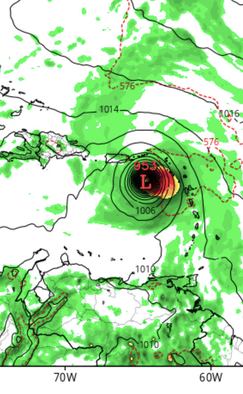
GFS has been consistently showing favorable conditions in the W Atlantic basin. Track is all over, which should be expected in +240 range.

06z raked the entire GA chain and maintained hurricane status, this area has to be watched closely. IMO a classic CV hurricane is going to come from this.

06z GFS also showed first TW going over all the GA which is likely why it didn’t develop. 00z Euro shows the first wave starting to develop in SE Bahamas.

Interesting how both GFS/Euro struggling to handle both waves catching each other.
4 likes   
Hurricane Eye Experience: David 79, Irene 99, Frances 04, Jeanne 04, Wilma 05... EYE COMING MY WAY IN 2024…
Hurricane Brush Experience: Andrew 92, Erin 95, Floyd 99, Matthew 16, Irma 17, Ian 22, Nicole 22…

User avatar
skyline385
Category 5
Category 5
Posts: 2728
Age: 35
Joined: Wed Aug 26, 2020 11:15 pm
Location: Houston TX

Re: 2022 Global Model Runs Discussion (Out thru day 16)

#1770 Postby skyline385 » Sun Aug 21, 2022 9:27 am

weeniepatrol wrote:Please use ensembles guys. 0z GEFS most active run yet

https://imgur.com/i33qFkv


Well we have two waves in the Atlantic without a clear defined center interacting with each other while trying to develop. Any model whether deterministic or ensemble is going to struggle with it and because of that, ensembles have been just as clueless as well. Some runs have more activity in the open Atlantic while some seem to favour the West Atlantic. And while 0Z GEFS had a good amount of activity, 06Z GEFS came out with a much lower development for the waves. So honestly not much we can do right except to wait. The one thing ensembles do suggest is that the environment has very likely become favorable for development.
1 likes   

User avatar
Spacecoast
Category 2
Category 2
Posts: 758
Joined: Thu Aug 31, 2017 2:03 pm

Re: 2022 Global Model Runs Discussion (Out thru day 16)

#1771 Postby Spacecoast » Sun Aug 21, 2022 10:50 am

skyline385 wrote:
weeniepatrol wrote:Please use ensembles guys. 0z GEFS most active run yet

https://imgur.com/i33qFkv


Well we have two waves in the Atlantic without a clear defined center interacting with each other while trying to develop. Any model whether deterministic or ensemble is going to struggle with it and because of that, ensembles have been just as clueless as well. Some runs have more activity in the open Atlantic while some seem to favour the West Atlantic. And while 0Z GEFS had a good amount of activity, 06Z GEFS came out with a much lower development for the waves. So honestly not much we can do right except to wait. The one thing ensembles do suggest is that the environment has very likely become favorable for development.


Why is it that the ensembles (both EPS & GEFS), seem to find a break in the ridge between 45-55W, while their operational (ECMF & GFS) don't see it, and continue west?

Usually the ensemble mean track doesn't differ that much from operational track.
0 likes   

User avatar
skyline385
Category 5
Category 5
Posts: 2728
Age: 35
Joined: Wed Aug 26, 2020 11:15 pm
Location: Houston TX

Re: 2022 Global Model Runs Discussion (Out thru day 16)

#1772 Postby skyline385 » Sun Aug 21, 2022 11:06 am

Spacecoast wrote:
skyline385 wrote:
weeniepatrol wrote:Please use ensembles guys. 0z GEFS most active run yet

https://imgur.com/i33qFkv


Well we have two waves in the Atlantic without a clear defined center interacting with each other while trying to develop. Any model whether deterministic or ensemble is going to struggle with it and because of that, ensembles have been just as clueless as well. Some runs have more activity in the open Atlantic while some seem to favour the West Atlantic. And while 0Z GEFS had a good amount of activity, 06Z GEFS came out with a much lower development for the waves. So honestly not much we can do right except to wait. The one thing ensembles do suggest is that the environment has very likely become favorable for development.


Why is it that the ensembles (both EPS & GEFS), seem to find a break in the ridge between 45-55W, while their operational (ECMF & GFS) don't see it, and continue west?

Usually the ensemble mean track doesn't differ that much from operational track.


Typically the ensembles start agreeing once we have a well defined center but right now, there are two waves competing which other to form their own centers which leaves a host of possibilities open. Which will be the first one to form a center, how much it will intensify and how it will affect the other one, just a whole lot of stuff going on for ensembles to agree on. Most of the solutions which seem to find a break in the ridge are the ones which RI in the MDR and hence are able to push through before the ridge builds up I think but very hard to say without looking at those members specifically.
3 likes   

BobHarlem
Category 5
Category 5
Posts: 2111
Joined: Thu Oct 20, 2005 6:11 pm

Re: 2022 Global Model Runs Discussion (Out thru day 16)

#1773 Postby BobHarlem » Sun Aug 21, 2022 11:11 am

so far GFS 12z coming in stronger than 6z, cmc takes it weak (but discernible, which is more than 0z had) into the Bahamas.
Last edited by BobHarlem on Sun Aug 21, 2022 11:35 am, edited 2 times in total.
0 likes   

User avatar
skyline385
Category 5
Category 5
Posts: 2728
Age: 35
Joined: Wed Aug 26, 2020 11:15 pm
Location: Houston TX

Re: 2022 Global Model Runs Discussion (Out thru day 16)

#1774 Postby skyline385 » Sun Aug 21, 2022 11:27 am

BobHarlem wrote:so far GFS 12z coming in stronger than 6z


It started off nicely but this isn't looking good at all

EDIT: Classic GFS, system continues to RI while being surrounded by dry air on all sides

Image
0 likes   

User avatar
Hurricaneman
Category 5
Category 5
Posts: 7351
Age: 45
Joined: Tue Aug 31, 2004 3:24 pm
Location: central florida

Re: 2022 Global Model Runs Discussion (Out thru day 16)

#1775 Postby Hurricaneman » Sun Aug 21, 2022 11:50 am

skyline385 wrote:
BobHarlem wrote:so far GFS 12z coming in stronger than 6z


It started off nicely but this isn't looking good at all

EDIT: Classic GFS, system continues to RI while being surrounded by dry air on all sides

https://i.imgur.com/HnU7M1J.png


That 998 system is not this system, that’s the system over west Africa. This system is the wave by the lesser Antilles
0 likes   

User avatar
NotSparta
Professional-Met
Professional-Met
Posts: 1670
Age: 23
Joined: Fri Aug 18, 2017 8:24 am
Location: Naples, FL
Contact:

Re: 2022 Global Model Runs Discussion (Out thru day 16)

#1776 Postby NotSparta » Sun Aug 21, 2022 11:51 am

skyline385 wrote:
BobHarlem wrote:so far GFS 12z coming in stronger than 6z


It started off nicely but this isn't looking good at all

EDIT: Classic GFS, system continues to RI while being surrounded by dry air on all sides

https://i.imgur.com/HnU7M1J.png


It doesn't matter if there's dry air, if the system has a core and shear is low it's usually fine unless there's an EWRC. Otherwise, how would you get dry air into the storm?
7 likes   
This post was probably an opinion of mine, and in no way is official. Please refer to http://www.hurricanes.gov for official tropical analysis and advisories.

My website, with lots of tropical wx graphics, including satellite and recon: http://cyclonicwx.com

lsuhurricane
Category 1
Category 1
Posts: 251
Joined: Tue Aug 15, 2017 2:53 pm

Re: 2022 Global Model Runs Discussion (Out thru day 16)

#1777 Postby lsuhurricane » Sun Aug 21, 2022 11:51 am

Near exact location and strength compared to 06z for the second wave rolling off of Africa on the 12z GFS. . Cat 2/3 near the Greater Antilles.

Dangerous steering on both. Almost uncanny how similar the runs are, even at the 360hr mark.
Last edited by lsuhurricane on Sun Aug 21, 2022 12:11 pm, edited 1 time in total.
0 likes   

User avatar
Blown Away
S2K Supporter
S2K Supporter
Posts: 10147
Joined: Wed May 26, 2004 6:17 am

Re: 2022 Global Model Runs Discussion (Out thru day 16)

#1778 Postby Blown Away » Sun Aug 21, 2022 11:53 am

Image

12z GFS continues showing a MH into NE Caribbean.
0 likes   
Hurricane Eye Experience: David 79, Irene 99, Frances 04, Jeanne 04, Wilma 05... EYE COMING MY WAY IN 2024…
Hurricane Brush Experience: Andrew 92, Erin 95, Floyd 99, Matthew 16, Irma 17, Ian 22, Nicole 22…

User avatar
cycloneye
Admin
Admin
Posts: 145366
Age: 68
Joined: Thu Oct 10, 2002 10:54 am
Location: San Juan, Puerto Rico

Re: 2022 Global Model Runs Discussion (Out thru day 16)

#1779 Postby cycloneye » Sun Aug 21, 2022 12:02 pm

Moved a few posts from the Tropical Wave near Cabo Verde thread to here as what GFS is showing is wave now inside Africa.
1 likes   
Visit the Caribbean-Central America Weather Thread where you can find at first post web cams,radars
and observations from Caribbean basin members Click Here

User avatar
skyline385
Category 5
Category 5
Posts: 2728
Age: 35
Joined: Wed Aug 26, 2020 11:15 pm
Location: Houston TX

2022 Global Model Runs Discussion (Out thru day 16)

#1780 Postby skyline385 » Sun Aug 21, 2022 12:15 pm

NotSparta wrote:
skyline385 wrote:
BobHarlem wrote:so far GFS 12z coming in stronger than 6z


It started off nicely but this isn't looking good at all

EDIT: Classic GFS, system continues to RI while being surrounded by dry air on all sides

https://i.imgur.com/HnU7M1J.png


It doesn't matter if there's dry air, if the system has a core and shear is low it's usually fine unless there's an EWRC. Otherwise, how would you get dry air into the storm?


I agree for a well developed system which has a core, but look at the screenshot I posted above. The system was weak with dry air being sucked into it through the south, it still somehow manages to completely close itself off and build a core strong enough to prevent any dry air intrusion on all quadrants while continuing to RI into a major. That to me seems a little too much...
Last edited by skyline385 on Sun Aug 21, 2022 12:15 pm, edited 3 times in total.
0 likes   


Return to “Talkin' Tropics”

Who is online

Users browsing this forum: Cdenton12, Stratton23, USTropics and 59 guests