2022 Global Model Runs Discussion (Out thru day 16)

This is the general tropical discussion area. Anyone can take their shot at predicting a storms path.

Moderator: S2k Moderators

Forum rules

The posts in this forum are NOT official forecasts and should not be used as such. They are just the opinion of the poster and may or may not be backed by sound meteorological data. They are NOT endorsed by any professional institution or STORM2K. For official information, please refer to products from the National Hurricane Center and National Weather Service.

Help Support Storm2K
Message
Author
User avatar
Cpv17
Category 5
Category 5
Posts: 4979
Joined: Wed Dec 07, 2016 2:24 pm
Location: Wharton/El Campo, TX

Re: 2022 Global Model Runs Discussion (Out thru day 16)

#1801 Postby Cpv17 » Sun Aug 21, 2022 4:21 pm


So basically everything that comes off Africa is OTS according to the EPS.
0 likes   

sma10
Category 5
Category 5
Posts: 1710
Joined: Tue Aug 02, 2005 1:13 pm

Re: 2022 Global Model Runs Discussion (Out thru day 16)

#1802 Postby sma10 » Sun Aug 21, 2022 4:25 pm

wxman57 wrote:Major hurricane to strike Houston/Galveston Sept. 8th. No doubt about it, the 12Z GFS is always right at 384 hrs. Ridge to the north weakening a little. Yep, right to Houston. Going fill up my four 5-gal gas cans now and buy all the water in Kroger.


Let's not be hasty.
The first, and most important, question is: do you have vacation plans?
2 likes   

User avatar
Blown Away
S2K Supporter
S2K Supporter
Posts: 10147
Joined: Wed May 26, 2004 6:17 am

Re: 2022 Global Model Runs Discussion (Out thru day 16)

#1803 Postby Blown Away » Sun Aug 21, 2022 4:27 pm

Cpv17 wrote:


So basically everything that comes off Africa is OTS according to the EPS.


It changes every model run and will continue until this TW reaches @60W in @8 days.
1 likes   
Hurricane Eye Experience: David 79, Irene 99, Frances 04, Jeanne 04, Wilma 05... EYE COMING MY WAY IN 2024…
Hurricane Brush Experience: Andrew 92, Erin 95, Floyd 99, Matthew 16, Irma 17, Ian 22, Nicole 22…

User avatar
NotSparta
Professional-Met
Professional-Met
Posts: 1670
Age: 23
Joined: Fri Aug 18, 2017 8:24 am
Location: Naples, FL
Contact:

Re: 2022 Global Model Runs Discussion (Out thru day 16)

#1804 Postby NotSparta » Sun Aug 21, 2022 4:30 pm

lsuhurricane wrote:https://www.tropicaltidbits.com/analysis/models/gfs-ens/2022082112/gfs-ememb_lowlocs_atl_46.png

Very intense ensemble support on the 12z GEFS. Note the blue high pressure anomalies anchored around FL and to the east. Should keep these moving to the west in the short term.


That's not high pressure anomalies, the blue shading just represents lower spread in pressure values (so more confidence)
1 likes   
This post was probably an opinion of mine, and in no way is official. Please refer to http://www.hurricanes.gov for official tropical analysis and advisories.

My website, with lots of tropical wx graphics, including satellite and recon: http://cyclonicwx.com

User avatar
skyline385
Category 5
Category 5
Posts: 2728
Age: 35
Joined: Wed Aug 26, 2020 11:15 pm
Location: Houston TX

Re: 2022 Global Model Runs Discussion (Out thru day 16)

#1805 Postby skyline385 » Sun Aug 21, 2022 4:36 pm

Blown Away wrote:
Cpv17 wrote:


So basically everything that comes off Africa is OTS according to the EPS.


It changes every model run and will continue until this TW reaches @60W in @8 days.


It does but surprisingly there has been an ongoing trend with the EPS that more members seem to be recurving which is odd cause typically the EPS has a ridge bias.
0 likes   

User avatar
skyline385
Category 5
Category 5
Posts: 2728
Age: 35
Joined: Wed Aug 26, 2020 11:15 pm
Location: Houston TX

Re: 2022 Global Model Runs Discussion (Out thru day 16)

#1806 Postby skyline385 » Sun Aug 21, 2022 4:38 pm

NotSparta wrote:
lsuhurricane wrote:https://www.tropicaltidbits.com/analysis/models/gfs-ens/2022082112/gfs-ememb_lowlocs_atl_46.png

Very intense ensemble support on the 12z GEFS. Note the blue high pressure anomalies anchored around FL and to the east. Should keep these moving to the west in the short term.


That's not high pressure anomalies, the blue shading just represents lower spread in pressure values (so more confidence)


Think he was talking about the individual high pressure members in blue located around FL. Like you said, the lower spread would suggest that there is more confidence in the ridging over Florida.
2 likes   

User avatar
Hammy
Category 5
Category 5
Posts: 5849
Age: 41
Joined: Fri May 25, 2012 5:25 pm
Contact:

Re: 2022 Global Model Runs Discussion (Out thru day 16)

#1807 Postby Hammy » Sun Aug 21, 2022 4:54 pm

skyline385 wrote:
Blown Away wrote:
Cpv17 wrote:
So basically everything that comes off Africa is OTS according to the EPS.


It changes every model run and will continue until this TW reaches @60W in @8 days.


It does but surprisingly there has been an ongoing trend with the EPS that more members seem to be recurving which is odd cause typically the EPS has a ridge bias.


They're still coming off at a higher latitude--anything that exits close to or north of 15 isn't making it across the Atlantic.
1 likes   
The above post is not official and should not be used as such. It is the opinion of the poster and may or may not be backed by sound meteorological data. It is not endorsed by any professional institution or storm2k.org. For official information, please refer to the NHC and NWS products.

User avatar
wxman57
Moderator-Pro Met
Moderator-Pro Met
Posts: 22979
Age: 67
Joined: Sat Jun 21, 2003 8:06 pm
Location: Houston, TX (southwest)

Re: 2022 Global Model Runs Discussion (Out thru day 16)

#1808 Postby wxman57 » Sun Aug 21, 2022 5:05 pm

SoupBone wrote:
wxman57 wrote:Major hurricane to strike Houston/Galveston Sept. 8th. No doubt about it, the 12Z GFS is always right at 384 hrs. Ridge to the north weakening a little. Yep, right to Houston. Going fill up my four 5-gal gas cans now and buy all the water in Kroger.


Is that spawning of the central American wave?


I can trace the 850mb vorticity to over central Africa. GFS has it moving off the west coast of Africa Wednesday night.
1 likes   

User avatar
aspen
Category 5
Category 5
Posts: 8818
Joined: Sat Oct 12, 2019 7:10 pm
Location: Connecticut, USA

Re: 2022 Global Model Runs Discussion (Out thru day 16)

#1809 Postby aspen » Sun Aug 21, 2022 5:29 pm

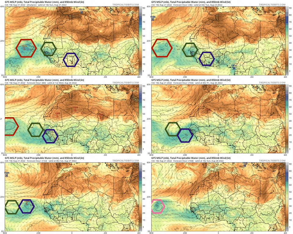
18z GFS has the same evolution of the second system as prior runs:

1.) A relatively north wave emerges on August 25th

2.) Another wave, this one much further south, emerges within 24 hours

3.) The two waves merge and seemingly form some area of rotation

4.) That southern wave has the dominant vorticity and rotates within the broader envelope. This is what causes it to get drawn north a bit but then return to a lower latitude

5.) A TC develops either during or after the max vorticity gets drawn up north
5 likes   
Irene '11 Sandy '12 Hermine '16 5/15/2018 Derecho Fay '20 Isaias '20 Elsa '21 Henri '21 Ida '21

I am only a meteorology enthusiast who knows a decent amount about tropical cyclones. Look to the professional mets, the NHC, or your local weather office for the best information.

Visioen
S2K Supporter
S2K Supporter
Posts: 286
Joined: Sat Sep 02, 2017 2:08 pm
Location: Belgium, Europe

Re: 2022 Global Model Runs Discussion (Out thru day 16)

#1810 Postby Visioen » Sun Aug 21, 2022 5:56 pm

Really curious how this will pan out. Gfs with some consistency at least.
2 likes   

User avatar
aspen
Category 5
Category 5
Posts: 8818
Joined: Sat Oct 12, 2019 7:10 pm
Location: Connecticut, USA

Re: 2022 Global Model Runs Discussion (Out thru day 16)

#1811 Postby aspen » Sun Aug 21, 2022 6:05 pm

GFS has a major heading north of the islands this run. Probably OTS, because not a single run has managed to make landfall north of Florida.
0 likes   
Irene '11 Sandy '12 Hermine '16 5/15/2018 Derecho Fay '20 Isaias '20 Elsa '21 Henri '21 Ida '21

I am only a meteorology enthusiast who knows a decent amount about tropical cyclones. Look to the professional mets, the NHC, or your local weather office for the best information.

Carolinagirl18
Tropical Low
Tropical Low
Posts: 15
Joined: Wed Aug 14, 2019 6:47 pm

Re: 2022 Global Model Runs Discussion (Out thru day 16)

#1812 Postby Carolinagirl18 » Sun Aug 21, 2022 6:06 pm

aspen wrote:GFS has a major heading north of the islands this run. Probably OTS, because not a single run has managed to make landfall north of Florida.

NC will probably get this one.
0 likes   

User avatar
SoupBone
Category 5
Category 5
Posts: 3111
Joined: Tue Sep 20, 2005 5:24 pm

Re: 2022 Global Model Runs Discussion (Out thru day 16)

#1813 Postby SoupBone » Sun Aug 21, 2022 6:21 pm

Carolinagirl18 wrote:
aspen wrote:GFS has a major heading north of the islands this run. Probably OTS, because not a single run has managed to make landfall north of Florida.

NC will probably get this one.


If that's the same one from last run, the GFS is all over the place. That last run was headed toward Texas. We need like another week. :lol:
1 likes   
Personal Forecast Disclaimer:
The posts in this forum are NOT official forecast and should not be used as such. They are just the opinion of the poster and may or may not be backed by sound meteorological data. They are NOT endorsed by any professional institution or storm2k.org. For official information, please refer to the NHC and NWS products.

User avatar
Teban54
Category 5
Category 5
Posts: 3206
Joined: Sat May 19, 2018 1:19 pm

Re: 2022 Global Model Runs Discussion (Out thru day 16)

#1814 Postby Teban54 » Sun Aug 21, 2022 6:28 pm

SoupBone wrote:
Carolinagirl18 wrote:
aspen wrote:GFS has a major heading north of the islands this run. Probably OTS, because not a single run has managed to make landfall north of Florida.

NC will probably get this one.


If that's the same one from last run, the GFS is all over the place. That last run was headed toward Texas. We need like another week. :lol:

384-hour model runs for a wave that has not yet left Africa are not good for tracks, anyway. Irma and Florence are prime examples of this.

The development signal is more important at this stage. Of course, it's entirely possible that models drop development after splash down, but at least this time it's more believable, as the preceding wave helps clear out SAL.
2 likes   

User avatar
AJC3
Admin
Admin
Posts: 3999
Age: 61
Joined: Tue Aug 31, 2004 7:04 pm
Location: Ballston Spa, New York
Contact:

Re: 2022 Global Model Runs Discussion (Out thru day 16)

#1815 Postby AJC3 » Sun Aug 21, 2022 6:53 pm

LarryWx wrote:I know it is from a wave west of the one now just west of the CVs and may be the one recently near 40W: ICON keeps developing a low just E of the L Antilles that I can't find on any of the other models. Anyone else notice this?


I took a look at that 18Z ICON run. It shows a weak spot low near 7N 51W in about 6hr, then gradually spins it up and moves it slowly WNW-NW toward the LA. It appears to come from the ITCZ, just ahead of the wave near 47/48W. There's very little deep convection in that part of the ITCZ right now, so I'd bet the farm it's some sort of bogus feedback issue with the model. TBH, I hardly ever look at the ICON - my first impression was that its output is generally... :Can:
5 likes   

User avatar
REDHurricane
Category 1
Category 1
Posts: 396
Age: 27
Joined: Sun Jul 03, 2022 2:36 pm
Location: Northeast Pacific Ocean

Re: 2022 Global Model Runs Discussion (Out thru day 16)

#1816 Postby REDHurricane » Sun Aug 21, 2022 7:11 pm

aspen wrote:18z GFS has the same evolution of the second system as prior runs:

1.) A relatively north wave emerges on August 25th

2.) Another wave, this one much further south, emerges within 24 hours

3.) The two waves merge and seemingly form some area of rotation

4.) That southern wave has the dominant vorticity and rotates within the broader envelope. This is what causes it to get drawn north a bit but then return to a lower latitude

5.) A TC develops either during or after the max vorticity gets drawn up north


Here is my attempt at making a gif highlighting each wave -- the red wave is the current NHC area of interest, the green wave is the northern wave, and the purple wave is the southern wave. The green wave moves off Africa around 00z August 24th, the purple wave comes around 24 hours after; the purple wave moves faster than the green wave and the two end up merging around a week from today.

Image
9 likes   

User avatar
Teban54
Category 5
Category 5
Posts: 3206
Joined: Sat May 19, 2018 1:19 pm

Re: 2022 Global Model Runs Discussion (Out thru day 16)

#1817 Postby Teban54 » Sun Aug 21, 2022 7:15 pm

REDHurricane wrote:
aspen wrote:18z GFS has the same evolution of the second system as prior runs:

1.) A relatively north wave emerges on August 25th

2.) Another wave, this one much further south, emerges within 24 hours

3.) The two waves merge and seemingly form some area of rotation

4.) That southern wave has the dominant vorticity and rotates within the broader envelope. This is what causes it to get drawn north a bit but then return to a lower latitude

5.) A TC develops either during or after the max vorticity gets drawn up north


Here is my attempt at making a gif highlighting each wave -- the red wave is the current NHC area of interest, the green wave is the northern wave, and the purple wave is the southern wave. The green wave moves off Africa around 00z August 24th, the purple wave comes around 24 hours after; the purple wave moves faster than the green wave and the two end up merging around a week from today.

https://media.giphy.com/media/ylsmxMQCq3AZiT79HB/giphy.gif

If the wave merging happens like GFS suggests, the GEFS and EPS ensemble members that intensify in the middle of the MDR are suspect. One would expect this to result in a more westward track similar to the operationals. Just my amateur guess.
0 likes   

User avatar
Blown Away
S2K Supporter
S2K Supporter
Posts: 10147
Joined: Wed May 26, 2004 6:17 am

Re: 2022 Global Model Runs Discussion (Out thru day 16)

#1818 Postby Blown Away » Sun Aug 21, 2022 7:30 pm

Todays GFS/Euro ensembles suggest the most likely outcome is a safe recurve OTS. GFS keeps delaying slightly in the long range today. Especially with the TW’s moving off Africa at a high latitude, very hard to make it across when starting @15N.
Last edited by Blown Away on Sun Aug 21, 2022 8:08 pm, edited 1 time in total.
0 likes   
Hurricane Eye Experience: David 79, Irene 99, Frances 04, Jeanne 04, Wilma 05... EYE COMING MY WAY IN 2024…
Hurricane Brush Experience: Andrew 92, Erin 95, Floyd 99, Matthew 16, Irma 17, Ian 22, Nicole 22…

User avatar
Cpv17
Category 5
Category 5
Posts: 4979
Joined: Wed Dec 07, 2016 2:24 pm
Location: Wharton/El Campo, TX

Re: 2022 Global Model Runs Discussion (Out thru day 16)

#1819 Postby Cpv17 » Sun Aug 21, 2022 7:48 pm

Teban54 wrote:
REDHurricane wrote:
aspen wrote:18z GFS has the same evolution of the second system as prior runs:

1.) A relatively north wave emerges on August 25th

2.) Another wave, this one much further south, emerges within 24 hours

3.) The two waves merge and seemingly form some area of rotation

4.) That southern wave has the dominant vorticity and rotates within the broader envelope. This is what causes it to get drawn north a bit but then return to a lower latitude

5.) A TC develops either during or after the max vorticity gets drawn up north


Here is my attempt at making a gif highlighting each wave -- the red wave is the current NHC area of interest, the green wave is the northern wave, and the purple wave is the southern wave. The green wave moves off Africa around 00z August 24th, the purple wave comes around 24 hours after; the purple wave moves faster than the green wave and the two end up merging around a week from today.

https://media.giphy.com/media/ylsmxMQCq3AZiT79HB/giphy.gif

If the wave merging happens like GFS suggests, the GEFS and EPS ensemble members that intensify in the middle of the MDR are suspect. One would expect this to result in a more westward track similar to the operationals. Just my amateur guess.


I agree. I wouldn’t expect an OTS solution here. Often times when waves are still over Africa or just come off the coast, operationals and ensembles often times have them going OTS and then adjust further south and west as time goes on.
0 likes   

User avatar
wxman57
Moderator-Pro Met
Moderator-Pro Met
Posts: 22979
Age: 67
Joined: Sat Jun 21, 2003 8:06 pm
Location: Houston, TX (southwest)

Re: 2022 Global Model Runs Discussion (Out thru day 16)

#1820 Postby wxman57 » Sun Aug 21, 2022 8:07 pm

I feel better now. 18Z GFS keeps the major hurricane out of the Gulf. I'm sure it's correct THIS time. Looking like a storm-free August. No named storm since early July.
7 likes   


Return to “Talkin' Tropics”

Who is online

Users browsing this forum: duilaslol and 27 guests