SouthFLTropics wrote:If you want to watch some good weather model stuff, I suggest tuning in to the 12z GFS. Me thinks it is going to have some fun with our player from South America. At least it is looking that way so far.
Moderator: S2k Moderators


SouthFLTropics wrote:If you want to watch some good weather model stuff, I suggest tuning in to the 12z GFS. Me thinks it is going to have some fun with our player from South America. At least it is looking that way so far.
SFLcane wrote:SouthFLTropics wrote:If you want to watch some good weather model stuff, I suggest tuning in to the 12z GFS. Me thinks it is going to have some fun with our player from South America. At least it is looking that way so far.
https://i.postimg.cc/d0nP279m/gfgs.png


sma10 wrote:SFLcane wrote:SouthFLTropics wrote:If you want to watch some good weather model stuff, I suggest tuning in to the 12z GFS. Me thinks it is going to have some fun with our player from South America. At least it is looking that way so far.
https://i.postimg.cc/d0nP279m/gfgs.png
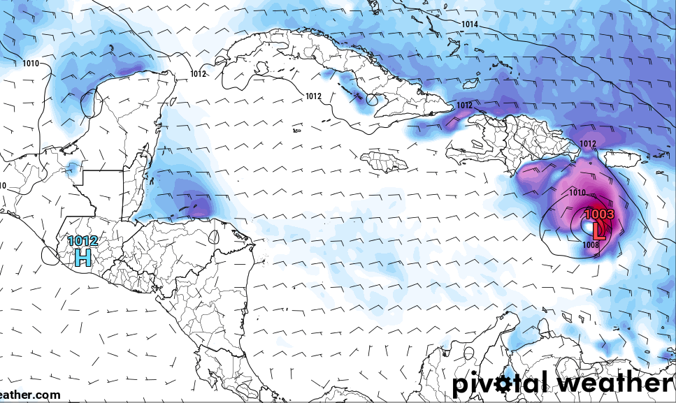
We'll see. Ironic this is the one area NHC does not have a lemon
lsuhurricane wrote:Would think this run will get the board poppin. Continental trough influence seems to be lessened. Lemon this afternoon seems likely


cycloneye wrote:With the peak of the season almost here, I thought GFS would have a good deal of activity, but it only has the SA area.
cycloneye wrote:With the peak of the season almost here, I thought GFS would have a good deal of activity, but it only has the SA area.


Teban54 wrote:cycloneye wrote:With the peak of the season almost here, I thought GFS would have a good deal of activity, but it only has the SA area.
Indeed, 12z GFS is the only one among recent runs that does not have a CV hurricane out to 342 hours.
This run still shows the 8/29 wave quickly organizing into a 1005mb TS soon after exiting Africa, in agreement with earlier runs and the Euro. But it stays weak as it tracks across the MDR.
(FWIW, this is either the same wave that 0z Euro has at 998mb after splashdown on 8/30 and keeps intensifying, or an adjacent wave.)


skyline385 wrote:Everyone is busy with the Gulf system, meanwhile the GFS just killed off both MDR systems
Users browsing this forum: NotSparta and 45 guests


