ATL: EARL - Models

Moderator: S2k Moderators

Message
Author
User avatar
Blown Away
S2K Supporter
S2K Supporter
Posts: 10140
Joined: Wed May 26, 2004 6:17 am

Re: ATL: INVEST 91L - Models

#41 Postby Blown Away » Sun Aug 28, 2022 6:54 am

jlauderdal wrote:
tolakram wrote:0Z Euro showing a really unfavorable upper air environment, lots of shear. Current map shows how shear looks at the moment, and it's pretty rough.

https://i.imgur.com/UtGKiGe.png

https://i.imgur.com/76tcqCz.png


meanwhile, development chances keep increasing, nhc likes it 30/70


Image

Yes, decent GFS W shift in long range, there is the sudden stop near Bahamas then yanked NE. Tells me there is a very fine line between recurve and going W into Bahamas & CONUS.
Last edited by Blown Away on Sun Aug 28, 2022 6:56 am, edited 1 time in total.
1 likes   
Hurricane Eye Experience: David 79, Irene 99, Frances 04, Jeanne 04, Wilma 05... EYE COMING MY WAY IN 2024…
Hurricane Brush Experience: Andrew 92, Erin 95, Floyd 99, Matthew 16, Irma 17, Ian 22, Nicole 22…

tolakram
Admin
Admin
Posts: 19990
Age: 61
Joined: Sun Aug 27, 2006 8:23 pm
Location: Florence, KY (name is Mark)

Re: ATL: INVEST 91L - Models

#42 Postby tolakram » Sun Aug 28, 2022 6:56 am

jlauderdal wrote:
tolakram wrote:0Z Euro showing a really unfavorable upper air environment, lots of shear. Current map shows how shear looks at the moment, and it's pretty rough.

https://i.imgur.com/UtGKiGe.png

https://i.imgur.com/76tcqCz.png


meanwhile, development chances keep increasing, nhc likes it 30/70


They have the FSU super ensembles which are almost always superior to what we can see. Dorian and Irma both went through the models stay weak phase. Always instructive to look at the old model threads, and one of the reasons I post lots of images and, selfishly, what I'm thinking at the moment. So far imgur (free account) has kept all my old images.
6 likes   
M a r k
- - - - -
Join us in chat: Storm2K Chatroom Invite. Android and IOS apps also available.

The posts in this forum are NOT official forecasts and should not be used as such. Posts are NOT endorsed by any professional institution or STORM2K.org. For official information and forecasts, please refer to NHC and NWS products.

tolakram
Admin
Admin
Posts: 19990
Age: 61
Joined: Sun Aug 27, 2006 8:23 pm
Location: Florence, KY (name is Mark)

Re: ATL: INVEST 91L - Models

#43 Postby tolakram » Sun Aug 28, 2022 7:00 am

UKMET 0Z
Image
0 likes   
M a r k
- - - - -
Join us in chat: Storm2K Chatroom Invite. Android and IOS apps also available.

The posts in this forum are NOT official forecasts and should not be used as such. Posts are NOT endorsed by any professional institution or STORM2K.org. For official information and forecasts, please refer to NHC and NWS products.

User avatar
cycloneye
Admin
Admin
Posts: 143867
Age: 68
Joined: Thu Oct 10, 2002 10:54 am
Location: San Juan, Puerto Rico

Re: ATL: INVEST 91L - Models

#44 Postby cycloneye » Sun Aug 28, 2022 8:00 am

Image

Image
2 likes   
Visit the Caribbean-Central America Weather Thread where you can find at first post web cams,radars
and observations from Caribbean basin members Click Here

User avatar
blp
Category 5
Category 5
Posts: 2840
Age: 46
Joined: Thu Sep 09, 2004 7:51 pm
Location: Miami, FL
Contact:

Re: ATL: INVEST 91L - Models

#45 Postby blp » Sun Aug 28, 2022 8:01 am

The Ukie seems to have it firmly entrenched under the ridge as well. Not good.

Image
4 likes   
The following post is NOT an official forecast and should not be used as such. It is just the opinion of the poster and may or may not be backed by sound meteorological data. It is NOT endorsed by any professional institution including storm2k.org For Official Information please refer to the NHC and NWS products.

User avatar
Blown Away
S2K Supporter
S2K Supporter
Posts: 10140
Joined: Wed May 26, 2004 6:17 am

Re: ATL: INVEST 91L - Models

#46 Postby Blown Away » Sun Aug 28, 2022 8:05 am

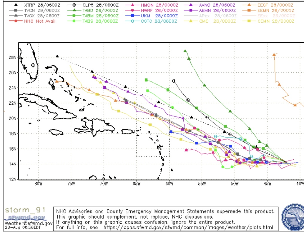
Image
06z
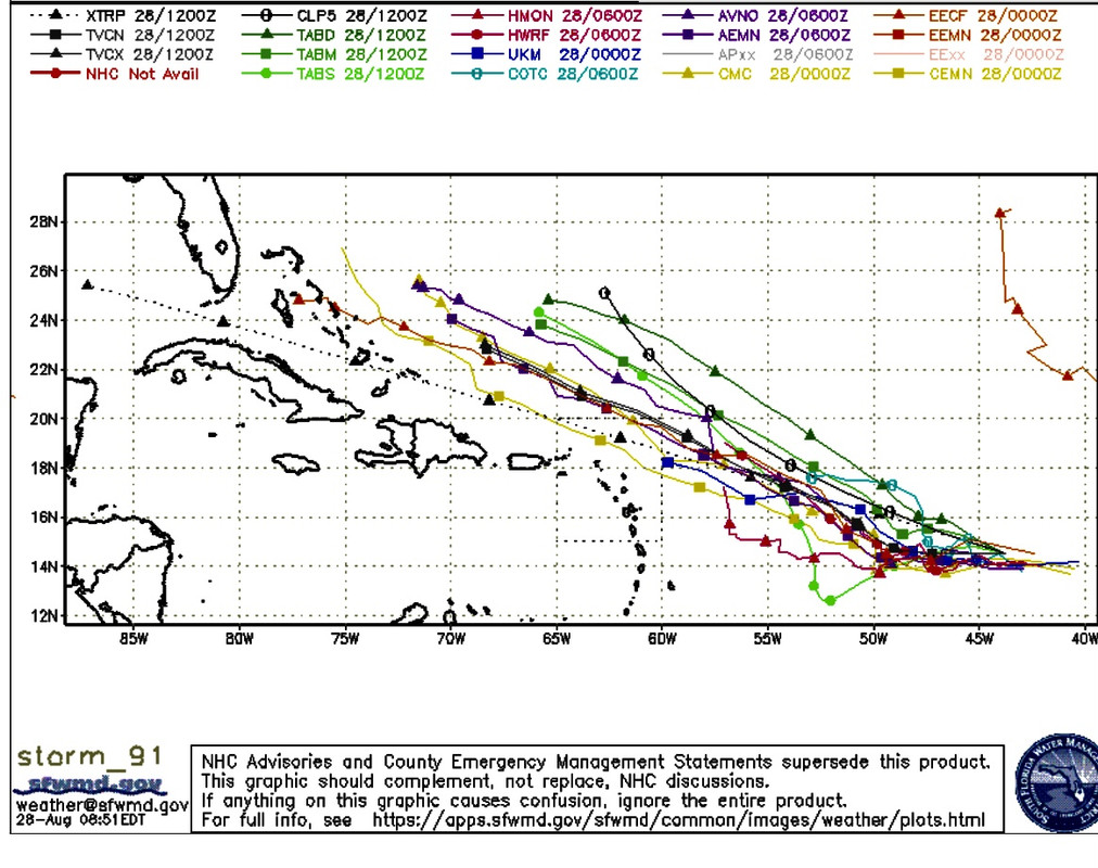
Image
12z

Subtle W guidance shift happening today.
3 likes   
Hurricane Eye Experience: David 79, Irene 99, Frances 04, Jeanne 04, Wilma 05... EYE COMING MY WAY IN 2024…
Hurricane Brush Experience: Andrew 92, Erin 95, Floyd 99, Matthew 16, Irma 17, Ian 22, Nicole 22…

User avatar
Kingarabian
S2K Supporter
S2K Supporter
Posts: 15827
Joined: Sat Aug 08, 2009 3:06 am
Location: Honolulu, Hawaii

Re: ATL: INVEST 91L - Models

#47 Postby Kingarabian » Sun Aug 28, 2022 8:31 am

06z GFS showed very weak steering when it started to bottom out over the Bahamas.

00z Euro because it had it much weaker had it drifting west near SFL.

Looks like there's potential for a US landfall regardless of intensity.
8 likes   
RIP Kobe Bryant

User avatar
skyline385
Category 5
Category 5
Posts: 2728
Age: 34
Joined: Wed Aug 26, 2020 11:15 pm
Location: Houston TX

Re: ATL: INVEST 91L - Models

#48 Postby skyline385 » Sun Aug 28, 2022 9:10 am

12Z early track guidance with intensities, HMON has it at 50 knots so hurricane models seem to be picking up on it

Image


Sent from my iPhone using Tapatalk
3 likes   

User avatar
Spacecoast
Category 2
Category 2
Posts: 758
Joined: Thu Aug 31, 2017 2:03 pm

Re: ATL: INVEST 91L - Models

#49 Postby Spacecoast » Sun Aug 28, 2022 9:36 am

06z GEFS:
Image
06Z GFS:
Image
4 likes   

User avatar
Blown Away
S2K Supporter
S2K Supporter
Posts: 10140
Joined: Wed May 26, 2004 6:17 am

Re: ATL: INVEST 91L - Models

#50 Postby Blown Away » Sun Aug 28, 2022 10:43 am

Kingarabian wrote:06z GFS showed very weak steering when it started to bottom out over the Bahamas.

00z Euro because it had it much weaker had it drifting west near SFL.

Looks like there's potential for a US landfall regardless of intensity.


12z GFS initialized SW of 06z. Let’s see if that makes any difference.
0 likes   
Hurricane Eye Experience: David 79, Irene 99, Frances 04, Jeanne 04, Wilma 05... EYE COMING MY WAY IN 2024…
Hurricane Brush Experience: Andrew 92, Erin 95, Floyd 99, Matthew 16, Irma 17, Ian 22, Nicole 22…

Fancy1001
Category 1
Category 1
Posts: 452
Joined: Thu Jul 16, 2020 10:16 pm

Re: ATL: INVEST 91L - Models

#51 Postby Fancy1001 » Sun Aug 28, 2022 10:52 am

Blown Away wrote:
Kingarabian wrote:06z GFS showed very weak steering when it started to bottom out over the Bahamas.

00z Euro because it had it much weaker had it drifting west near SFL.

Looks like there's potential for a US landfall regardless of intensity.


12z GFS initialized SW of 06z. Let’s see if that makes any difference.

Did you mean the Icon
0 likes   

Fancy1001
Category 1
Category 1
Posts: 452
Joined: Thu Jul 16, 2020 10:16 pm

Re: ATL: INVEST 91L - Models

#52 Postby Fancy1001 » Sun Aug 28, 2022 10:53 am

Blown Away wrote:
Kingarabian wrote:06z GFS showed very weak steering when it started to bottom out over the Bahamas.

00z Euro because it had it much weaker had it drifting west near SFL.

Looks like there's potential for a US landfall regardless of intensity.


12z GFS initialized SW of 06z. Let’s see if that makes any difference.

nevemind, for some reason i thought your post was at 10:43
0 likes   

User avatar
Iceresistance
Category 5
Category 5
Posts: 9279
Age: 21
Joined: Sat Oct 10, 2020 9:45 am
Location: Tecumseh, OK/Norman, OK

Re: ATL: INVEST 91L - Models

#53 Postby Iceresistance » Sun Aug 28, 2022 10:53 am

Fancy1001 wrote:
Blown Away wrote:
Kingarabian wrote:06z GFS showed very weak steering when it started to bottom out over the Bahamas.

00z Euro because it had it much weaker had it drifting west near SFL.

Looks like there's potential for a US landfall regardless of intensity.


12z GFS initialized SW of 06z. Let’s see if that makes any difference.

Did you mean the Icon

The GFS did initiate SW compared to 6z.
0 likes   
Bill 2015 & Beta 2020

Winter 2020-2021 :cold:

All observations are in Tecumseh, OK unless otherwise noted.

Winter posts are focused mainly for Oklahoma & Texas.

Take any of my forecasts with a grain of salt, refer to the NWS, SPC, and NHC for official information

Never say Never with weather! Because ANYTHING is possible!

Fancy1001
Category 1
Category 1
Posts: 452
Joined: Thu Jul 16, 2020 10:16 pm

Re: ATL: INVEST 91L - Models

#54 Postby Fancy1001 » Sun Aug 28, 2022 10:56 am

Iceresistance wrote:
Fancy1001 wrote:
Blown Away wrote:
12z GFS initialized SW of 06z. Let’s see if that makes any difference.

Did you mean the Icon

The GFS did initiate SW compared to 6z.

Yeah, I was confused because I misread the post time.
0 likes   

User avatar
Iceresistance
Category 5
Category 5
Posts: 9279
Age: 21
Joined: Sat Oct 10, 2020 9:45 am
Location: Tecumseh, OK/Norman, OK

Re: ATL: INVEST 91L - Models

#55 Postby Iceresistance » Sun Aug 28, 2022 10:59 am

Don't you even dare ICON . . .
0 likes   
Bill 2015 & Beta 2020

Winter 2020-2021 :cold:

All observations are in Tecumseh, OK unless otherwise noted.

Winter posts are focused mainly for Oklahoma & Texas.

Take any of my forecasts with a grain of salt, refer to the NWS, SPC, and NHC for official information

Never say Never with weather! Because ANYTHING is possible!

User avatar
skyline385
Category 5
Category 5
Posts: 2728
Age: 34
Joined: Wed Aug 26, 2020 11:15 pm
Location: Houston TX

Re: ATL: INVEST 91L - Models

#56 Postby skyline385 » Sun Aug 28, 2022 11:00 am

Well this 12Z ICON run is going to get people talking, 953mb at 180 hrs

Image
3 likes   

AutoPenalti
Category 5
Category 5
Posts: 4029
Age: 28
Joined: Mon Aug 17, 2015 4:16 pm
Location: Ft. Lauderdale, Florida

Re: ATL: INVEST 91L - Models

#57 Postby AutoPenalti » Sun Aug 28, 2022 11:01 am

what does ICON have at 500mb level?
0 likes   
The posts in this forum are NOT official forecasts and should not be used as such. They are just the opinion of the poster and may or may not be backed by sound meteorological data. They are NOT endorsed by any professional institution or STORM2K. For official information, please refer to products from the NHC and NWS.


Model Runs Cheat Sheet:
GFS (5:30 AM/PM, 11:30 AM/PM)
HWRF, GFDL, UKMET, NAVGEM (6:30-8:00 AM/PM, 12:30-2:00 AM/PM)
ECMWF (1:45 AM/PM)

TCVN
is a weighted averaged

User avatar
aspen
Category 5
Category 5
Posts: 8812
Joined: Sat Oct 12, 2019 7:10 pm
Location: Connecticut, USA

Re: ATL: INVEST 91L - Models

#58 Postby aspen » Sun Aug 28, 2022 11:07 am

12z GFS doesn’t have a good convective initialization. It shows much more wispy convection and not the blob over the developing LLC.
0 likes   
Irene '11 Sandy '12 Hermine '16 5/15/2018 Derecho Fay '20 Isaias '20 Elsa '21 Henri '21 Ida '21

I am only a meteorology enthusiast who knows a decent amount about tropical cyclones. Look to the professional mets, the NHC, or your local weather office for the best information.

SohCahToa
Tropical Low
Tropical Low
Posts: 48
Joined: Fri Jul 12, 2019 7:07 pm

Re: ATL: INVEST 91L - Models

#59 Postby SohCahToa » Sun Aug 28, 2022 11:12 am

skyline385 wrote:Well this 12Z ICON run is going to get people talking, 953mb at 180 hrs

https://s1.gifyu.com/images/icon_mslp_pcpn_watl_fh120-180.gif


Is that a left turn I see at the end of that run?
0 likes   

User avatar
Kingarabian
S2K Supporter
S2K Supporter
Posts: 15827
Joined: Sat Aug 08, 2009 3:06 am
Location: Honolulu, Hawaii

Re: ATL: INVEST 91L - Models

#60 Postby Kingarabian » Sun Aug 28, 2022 11:14 am

SohCahToa wrote:
skyline385 wrote:Well this 12Z ICON run is going to get people talking, 953mb at 180 hrs

https://s1.gifyu.com/images/icon_mslp_pcpn_watl_fh120-180.gif


Is that a left turn I see at the end of that run?

Decent SW dip on the ICON to finish the run.

12Z GFS through hour 120 is further SW compared to its previous runs. Will have track implications probably.
0 likes   
RIP Kobe Bryant


Return to “2022”

Who is online

Users browsing this forum: No registered users and 77 guests