2022 Indicators (SSTs/SAL/MSLP/Shear/Steering/Instability) and >Day 16 Models
Moderator: S2k Moderators
Forum rules

The posts in this forum are NOT official forecasts and should not be used as such. They are just the opinion of the poster and may or may not be backed by sound meteorological data. They are NOT endorsed by any professional institution or STORM2K. For official information, please refer to products from the National Hurricane Center and National Weather Service.
-
wxman57

- Moderator-Pro Met

- Posts: 23171
- Age: 68
- Joined: Sat Jun 21, 2003 8:06 pm
- Location: Houston, TX (southwest)
Re: 2022 Indicators (SSTs/SAL/MSLP/Shear/Steering/Instability) and >Day 16 Models
First hurricane of the season could be west of the Azores this weekend. NHC ignoring that feature so far.
2 likes
-
CFLHurricane

- Category 1

- Posts: 349
- Joined: Thu Mar 27, 2014 5:56 pm
- Location: Floriduh
Re: 2022 Indicators (SSTs/SAL/MSLP/Shear/Steering/Instability) and >Day 16 Models
Category5Kaiju wrote:Whatever happens going foward, whether it's in 2023, or 2024, or the next several years, I have optimism that scientists will eventually be able to determine what went wrong this year despite attempts to minimize bust forecasts after 2013, and incorporate whatever went wrong this year into our body of knowledge regarding the anatomy of an Atlantic hurricane season and what factors can cause this kind of unexpected, massive bust to occur.
With that being said, who really knows if 2031, for example, ends up as some weak La Nina from moderate El Nino transition year (which is arguably the best, historically speaking, ENSO state for heightened Atlantic activity) and has a super warm Canary current and tropical MDR and a rather cooler subtropics and only features 1914-level activity?
You have much more optimism than I do. I’m not sure we’ll learn much if anything from this season’s likely bust.
1 likes
I'm not a meteorologist, but I did stay at a motel 8.
-
cycloneye

- Admin

- Posts: 149266
- Age: 69
- Joined: Thu Oct 10, 2002 10:54 am
- Location: San Juan, Puerto Rico
Re: 2022 Indicators (SSTs/SAL/MSLP/Shear/Steering/Instability) and >Day 16 Models
Phil has this thread on data about the slow pace of the season. Look at the last one at the bottom.
https://twitter.com/philklotzbach/status/1564736102484680704
https://twitter.com/philklotzbach/status/1564736650676166657
https://twitter.com/philklotzbach/status/1564737904206680065
https://twitter.com/philklotzbach/status/1564736650676166657
https://twitter.com/philklotzbach/status/1564738301424062464
https://twitter.com/philklotzbach/status/1564738585823027200
0 likes
Visit the Caribbean-Central America Weather Thread where you can find at first post web cams,radars
and observations from Caribbean basin members Click Here
and observations from Caribbean basin members Click Here

Re: 2022 Indicators (SSTs/SAL/MSLP/Shear/Steering/Instability) and >Day 16 Models
I like the 1977 analogue…sure we don’t have an El Nino but we might as well have one given how hostile the Atlantic is.
0 likes

Re: 2022 Indicators (SSTs/SAL/MSLP/Shear/Steering/Instability) and >Day 16 Models
cycloneye wrote:Phil has this thread on data about the slow pace of the season. Look at the last one at the bottom.
https://twitter.com/philklotzbach/status/1564736102484680704
https://twitter.com/philklotzbach/status/1564736650676166657
https://twitter.com/philklotzbach/status/1564737904206680065
https://twitter.com/philklotzbach/status/1564736650676166657
https://twitter.com/philklotzbach/status/1564738301424062464
https://twitter.com/philklotzbach/status/1564738585823027200
SSTs remain very high and shear is not bad either:
https://twitter.com/philklotzbach/status/1564737339363975168
https://twitter.com/philklotzbach/status/1564740849707016193
0 likes
TC naming lists: retirements and intensity
Most aggressive Advisory #1's in North Atlantic (cr. kevin for starting the list)
Most aggressive Advisory #1's in North Atlantic (cr. kevin for starting the list)
-
tolakram
- Admin
- Posts: 20178
- Age: 62
- Joined: Sun Aug 27, 2006 8:23 pm
- Location: Florence, KY (name is Mark)
Re: 2022 Indicators (SSTs/SAL/MSLP/Shear/Steering/Instability) and >Day 16 Models
cycloneye wrote:Phil has this thread on data about the slow pace of the season. Look at the last one at the bottom.
https://twitter.com/philklotzbach/status/1564736102484680704
https://twitter.com/philklotzbach/status/1564736650676166657
https://twitter.com/philklotzbach/status/1564737904206680065
https://twitter.com/philklotzbach/status/1564736650676166657
https://twitter.com/philklotzbach/status/1564738301424062464
https://twitter.com/philklotzbach/status/1564738585823027200
Phil mentions both 3rd year nina and wave breaking in that thread.
3 likes
M a r k
- - - - -
Join us in chat: Storm2K Chatroom Invite. Android and IOS apps also available.
The posts in this forum are NOT official forecasts and should not be used as such. Posts are NOT endorsed by any professional institution or STORM2K.org. For official information and forecasts, please refer to NHC and NWS products.
-
tolakram
- Admin
- Posts: 20178
- Age: 62
- Joined: Sun Aug 27, 2006 8:23 pm
- Location: Florence, KY (name is Mark)
Re: 2022 Indicators (SSTs/SAL/MSLP/Shear/Steering/Instability) and >Day 16 Models
2 likes
M a r k
- - - - -
Join us in chat: Storm2K Chatroom Invite. Android and IOS apps also available.
The posts in this forum are NOT official forecasts and should not be used as such. Posts are NOT endorsed by any professional institution or STORM2K.org. For official information and forecasts, please refer to NHC and NWS products.
- - - - -
Join us in chat: Storm2K Chatroom Invite. Android and IOS apps also available.
The posts in this forum are NOT official forecasts and should not be used as such. Posts are NOT endorsed by any professional institution or STORM2K.org. For official information and forecasts, please refer to NHC and NWS products.

Re: 2022 Indicators (SSTs/SAL/MSLP/Shear/Steering/Instability) and >Day 16 Models
WiscoWx02 wrote:I like the 1977 analogue…sure we don’t have an El Nino but we might as well have one given how hostile the Atlantic is.
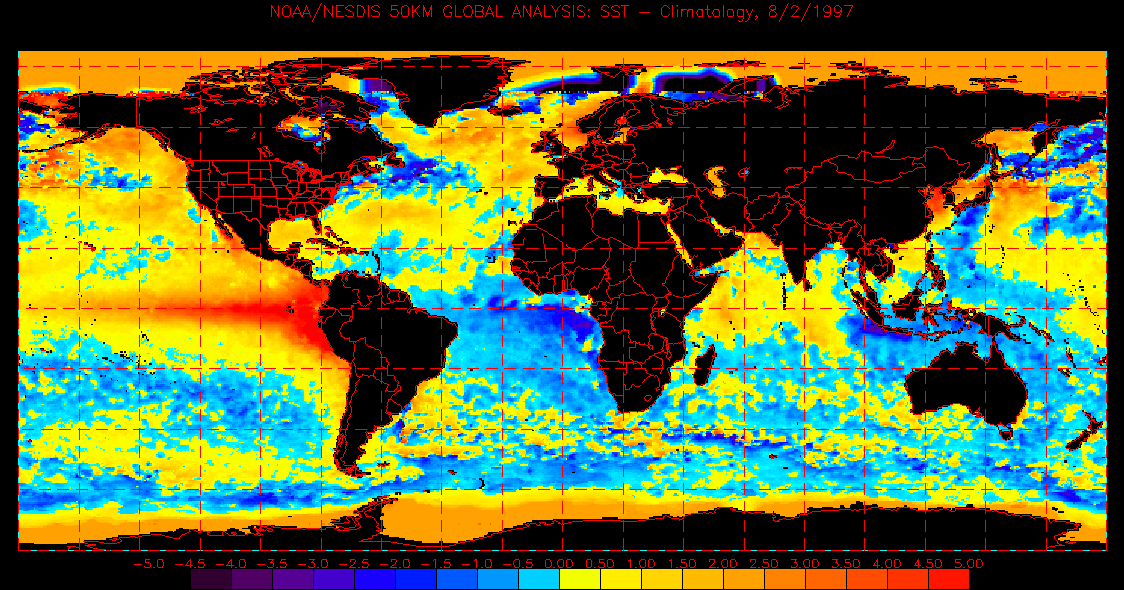
I’m 99% sure 97 was a super nino. Montserrat in the Caribbean erupted that year as well but obviously those two factors make the conditions somewhat opposite. Probably the near EPAC Nino conditions were regionally pretty similar, but I’m going off memory.
Edit yeah - the movie is slightly out of range but look at the heat content along the Mexican Rivera late summer
Sorry. Link compresses wrong. Try this
https://www.ospo.noaa.gov/data/sst/anom ... 2.1997.gif
0 likes
-
Category5Kaiju

- Category 5

- Posts: 4330
- Joined: Thu Dec 24, 2020 12:45 pm
- Location: Seattle and Phoenix
Re: 2022 Indicators (SSTs/SAL/MSLP/Shear/Steering/Instability) and >Day 16 Models
So it looks like some of the models are pretty enthusiastic about the prospect that 91L and the newly designated 10/30 disturbance could end up becoming quite strong at the mid-latitudes. I wonder if they (assuming they become big and strong enough) could theoretically "dent" the insanely high anomalies in the subtropics and end up providing some sort of litmus test as to whether even a temporary cooling of that part of the basin could allow for some more deep tropical instability.
0 likes
Unless explicitly stated, all info in my posts is based on my own opinions and observations. Tropical storms and hurricanes can be extremely dangerous. Refer to an accredited weather research agency or meteorologist if you need to make serious decisions regarding an approaching storm.
-
ElectricStorm

- Category 5
- Posts: 5139
- Age: 25
- Joined: Tue Aug 13, 2019 11:23 pm
- Location: Norman, OK
Re: 2022 Indicators (SSTs/SAL/MSLP/Shear/Steering/Instability) and >Day 16 Models
There's a decent chance we could see 3 named storms within the next week. I think all 3 could develop although I'm less sure about the wave exiting Africa it seems to be pretty broad and models have been off and on with it.
I could easily see a 2018 type season from here on out in terms of numbers (yeah I realize ENSO and SSTs were different)
Besides, most of the big MDR storms over the last several years have been in Sept rather than Aug so it wouldn't surprise me at all if we start seeing some quality storms over the next several weeks.
2 likes
B.S Meteorology, University of Oklahoma '25
Please refer to the NHC, NWS, or SPC for official information.
Please refer to the NHC, NWS, or SPC for official information.
Re: 2022 Indicators (SSTs/SAL/MSLP/Shear/Steering/Instability) and >Day 16 Models
Category5Kaiju wrote:So it looks like some of the models are pretty enthusiastic about the prospect that 91L and the newly designated 10/30 disturbance could end up becoming quite strong at the mid-latitudes. I wonder if they (assuming they become big and strong enough) could theoretically "dent" the insanely high anomalies in the subtropics and end up providing some sort of litmus test as to whether even a temporary cooling of that part of the basin could allow for some more deep tropical instability.
Too vast of an oceanic region imho. GFS actually keeps 91L around for the duration of its run. Gotta be 25 units of Ace if that happens. I’m also tripping on that crazy low moving down toward the UK. Icon had it as well. That’s an odd shaped system for this time of year in that region. Almost had a South Pacific look to it.
0 likes
-
gatorcane

- S2K Supporter

- Posts: 23708
- Age: 48
- Joined: Sun Mar 13, 2005 3:54 pm
- Location: Boca Raton, FL
Re: 2022 Indicators (SSTs/SAL/MSLP/Shear/Steering/Instability) and >Day 16 Models
So far, pre-season indicators of steering that would threaten the islands and CONUS is not materializing. Fingers crossed that continues.In fact I think it was the seasonal ECMWF that had the bulk of the activity recurving north of the islands and that has been the case so far.
0 likes
Re: 2022 Indicators (SSTs/SAL/MSLP/Shear/Steering/Instability) and >Day 16 Models
gatorcane wrote:So far, pre-season indicators of steering that would threaten the islands and CONUS is not materializing. Fingers crossed that continues.In fact I think it was the seasonal ECMWF that had the bulk of the activity recurving north of the islands and that has been the case so far.
You saw the most recent output? It’s a few pages back if not.
0 likes
-
NXStumpy_Robothing
- Category 1
- Posts: 335
- Age: 25
- Joined: Fri Jun 05, 2020 11:50 pm
- Location: North Georgia
Re: 2022 Indicators (SSTs/SAL/MSLP/Shear/Steering/Instability) and >Day 16 Models
gatorcane wrote:So far, pre-season indicators of steering that would threaten the islands and CONUS is not materializing. Fingers crossed that continues. In fact I think it was the seasonal ECMWF that had the bulk of the activity recurving north of the islands and that has been the case so far.
For the most part there hasn't been much of anything to threaten land
I'd need to look at the anomalous ridging via NCEP Reanalysis but it would not surprise me if said ridging was there, but that there wasn't anything to take advantage of it because of (insert your favorite reason why here!). An odd season for sure, though it looks like the tropics are beginning to turn the corner in the Northern Hemisphere.
Here's hoping we're not very shortly eating our words as we head towards the climatological peak...
0 likes
Undergraduate Meteorology Student, Georgia Institute of Technology
-
crownweather

- S2K Supporter
- Posts: 602
- Age: 51
- Joined: Sat Aug 12, 2006 9:21 am
- Location: Sturbridge, Massachusetts
- Contact:
Re: 2022 Indicators (SSTs/SAL/MSLP/Shear/Steering/Instability) and >Day 16 Models
Steve wrote:CFLHurricane wrote:
Bastardi is sooo desperate for a landfalling hurricane it’s almost comical.
He was talking about Donna this weekend on the little of the Saturday Summary I could actually stand listening to. He's been waiting for that since the 1960's and talking about it for a couple decades. haha. It didn't appear to me that the front wave could get all the way to the SEUS, and maybe it can. But there seemed to be a pretty stark poleward motion several degrees east of the US. He said he'd talk about it next week whether he was right or wrong. I'd bet money he was wrong though from 9-10 days out if it's close, that's not all that bad minus the hype of the storm with hurricane winds in every coastal state.
I actually watched that video and honestly it didn't make sense at all meteorologically. The maps he brought up for Donna and tried to compare to 91-L were completely different in that their relative positions to the ridge/trough pattern were completely different.
The map he showed for Donna was when the storm was still, at the time, near the northern Leeward Islands. Compare that to the map he tried to compare 91L to, which was a model map for a position near the Bahamas. So, honestly, I'm not sure what he was trying to compare because there wasn't any comparison. As @CFLHurricane said, sometimes he's way too desperate for a landfalling hurricane & that blinds him to what's actually happening.
2 likes
Rob Lightbown
Crown Weather Services
https://crownweather.com
Crown Weather Services
https://crownweather.com

Re: 2022 Indicators (SSTs/SAL/MSLP/Shear/Steering/Instability) and >Day 16 Models
Mark has some interesting comments about what’s going on now and how things could change: https://m.youtube.com/watch?v=QKFwjr_Y6to
Big takeaway points:
1.) He thinks the ridiculously warm subtropics in both the Atlantic and WPac — in excess of 5C above average in some areas — are one of the factors resulting in the suppressed tropics. He’s mentioned the Tonga eruption theories in several videos but has leaned towards the mid-latitude SSTA configuration and nothing crazy
2.) It’s possible 91L and/or the newest AOI could tip the balance by using up OHC in the subtropics if they form and meander around for a while. He showed the 12z GFS run, which has 91L remaining as a hurricane north of 35N for days. A scenario like that could put a dent in the SSTA configuration and maybe tip things towards a more favorable rest of September by changing up the current patterns
3.) The MJO is going back into the null phase, but some Euro members and a lot of the JMA members have it swing back out into Phases 8/1. I think this might be after that early September suppressive CCKW
3 likes
Irene '11 Sandy '12 Hermine '16 5/15/2018 Derecho Fay '20 Isaias '20 Elsa '21 Henri '21 Ida '21
I am only a meteorology enthusiast who knows a decent amount about tropical cyclones. Look to the professional mets, the NHC, or your local weather office for the best information.
I am only a meteorology enthusiast who knows a decent amount about tropical cyclones. Look to the professional mets, the NHC, or your local weather office for the best information.
-
Hurricane Mike
- Category 2

- Posts: 675
- Joined: Tue Apr 10, 2018 7:44 am
Re: 2022 Indicators (SSTs/SAL/MSLP/Shear/Steering/Instability) and >Day 16 Models
Video on the abnormally slow tropics
https://youtu.be/UGQl2zf3qmY
https://youtu.be/UGQl2zf3qmY
0 likes
Re: 2022 Indicators (SSTs/SAL/MSLP/Shear/Steering/Instability) and >Day 16 Models
https://twitter.com/webberweather/status/1564791024332836864
It's not just Andy Hazelton anymore guys. Yes this is a SSTA analysis but let's face it, there are many other similarities beyond this.
It's not just Andy Hazelton anymore guys. Yes this is a SSTA analysis but let's face it, there are many other similarities beyond this.
1 likes
-
Category5Kaiju
- Category 5
- Posts: 4330
- Joined: Thu Dec 24, 2020 12:45 pm
- Location: Seattle and Phoenix
Re: 2022 Indicators (SSTs/SAL/MSLP/Shear/Steering/Instability) and >Day 16 Models
WiscoWx02 wrote:https://twitter.com/webberweather/status/1564791024332836864
It's not just Andy Hazelton anymore guys. Yes this is a SSTA analysis but let's face it, there are many other similarities beyond this.
Did this year have a THC collapse? Was 2013 a solid La Nina year? Did 2013 have crazy warm MDR sst anomalies? Did 2013 have an active early EPAC with major hurricanes? Did 2013 have NSs in August? I'm still unsure why people are comparing 2022 with 2013; yes both seem to be inactive, but the background reasons for why are so different.
I feel like there's a general, rather simplistic sort of idea that "we should lump 2013 with 2022 because both were inactive," but there are actually a wide number of differences between the two years that makes comparisons between the two rather misleading, at least from the way I see things.
9 likes
Unless explicitly stated, all info in my posts is based on my own opinions and observations. Tropical storms and hurricanes can be extremely dangerous. Refer to an accredited weather research agency or meteorologist if you need to make serious decisions regarding an approaching storm.

Re: 2022 Indicators (SSTs/SAL/MSLP/Shear/Steering/Instability) and >Day 16 Models
gatorcane wrote:So far, pre-season indicators of steering that would threaten the islands and CONUS is not materializing. Fingers crossed that continues.In fact I think it was the seasonal ECMWF that had the bulk of the activity recurving north of the islands and that has been the case so far.
I was just now thinking the same thing. If the current players on the field behave as models seem to be consistently forecasting, then i'd say we pretty much have taken Cape Verde systems off the table with regard to long track US threats. Latter threats from the south are an altogether different subject.
0 likes
Andy D
(For official information, please refer to the NHC and NWS products.)
(For official information, please refer to the NHC and NWS products.)
Who is online
Users browsing this forum: HurricaneRyan and 87 guests