2022 Indicators (SSTs/SAL/MSLP/Shear/Steering/Instability) and >Day 16 Models

This is the general tropical discussion area. Anyone can take their shot at predicting a storms path.

Moderator: S2k Moderators

Forum rules

The posts in this forum are NOT official forecasts and should not be used as such. They are just the opinion of the poster and may or may not be backed by sound meteorological data. They are NOT endorsed by any professional institution or STORM2K. For official information, please refer to products from the National Hurricane Center and National Weather Service.

Help Support Storm2K
Message
Author
User avatar
skyline385
Category 5
Category 5
Posts: 2728
Age: 35
Joined: Wed Aug 26, 2020 11:15 pm
Location: Houston TX

Re: 2022 Indicators (SSTs/SAL/MSLP/Shear/Steering/Instability) and >Day 16 Models

#3281 Postby skyline385 » Tue Aug 30, 2022 10:38 pm

Category5Kaiju wrote:
WiscoWx02 wrote:https://twitter.com/webberweather/status/1564791024332836864

It's not just Andy Hazelton anymore guys. Yes this is a SSTA analysis but let's face it, there are many other similarities beyond this.


Did this year have a THC collapse? Was 2013 a solid La Nina year? Did 2013 have crazy warm MDR sst anomalies? Did 2013 have an active early EPAC with major hurricanes? Did 2013 have NSs in August? I'm still unsure why people are comparing 2022 with 2013; yes both seem to be inactive, but the background reasons for why are so different.

I feel like there's a general, rather simplistic sort of idea that "we should lump 2013 with 2022 because both were inactive," but there are actually a wide number of differences between the two years that makes comparisons between the two rather misleading, at least from the way I see things.


In my opinion, Webb isn't some random dude and to me, his thoughts carry a lot of weight compared to hobbyists on the internet. And remember, Andy said a few days ago that NOAA HRD has started including 2013 in their briefings since the last couple of weeks as well. Phil also came out today with a long thread which basically winded down to how this season is not behaving as expected previously. WxMan has been also saying for weeks about how something is wrong with the MDR and has reduced his numbers multiple times, including just today. WeatherTiger's live ACE model has been on a steep decline for a few weeks now and dropped the ACE today to 106 from 170 at start of August.

Webb also isn't saying that this season is 100% similar to 2013, he is just saying that we may potentially have a similar bust on our hands looking at the SST anomalies. His point about how deep-layer stability is ignored in seasonal forecasts seems valid to me as we have seen how much the NATL has struggled this year and one of the reasons has been the lack on instability in the tropics.
Last edited by skyline385 on Tue Aug 30, 2022 10:59 pm, edited 3 times in total.
4 likes   

User avatar
Hammy
Category 5
Category 5
Posts: 5849
Age: 41
Joined: Fri May 25, 2012 5:25 pm
Contact:

Re: 2022 Indicators (SSTs/SAL/MSLP/Shear/Steering/Instability) and >Day 16 Models

#3282 Postby Hammy » Tue Aug 30, 2022 10:47 pm

WiscoWx02 wrote:https://twitter.com/webberweather/status/1564791024332836864

It's not just Andy Hazelton anymore guys. Yes this is a SSTA analysis but let's face it, there are many other similarities beyond this.


Except there really aren't. 2013 had a ton of near-depressions that just dissipated in places and at times they shouldn't. Winter-type 500mb lows forming in the tropical Atlantic (big reason we had no majors). Intense cold fronts bringing 65 degree highs to the Southeast. Waves were very small and barely making it off of Africa. In fact the monsoon trough in 2013 was all but nonexistent, and if anything, too far south.

None of that is true of this year.

Again, 2005 was similar to this year as well and this is being overlooked in favor of finding a quick and easy explanation.
7 likes   
The above post is not official and should not be used as such. It is the opinion of the poster and may or may not be backed by sound meteorological data. It is not endorsed by any professional institution or storm2k.org. For official information, please refer to the NHC and NWS products.

User avatar
CyclonicFury
Category 5
Category 5
Posts: 2025
Age: 26
Joined: Sun Jul 02, 2017 12:32 pm
Location: NC
Contact:

Re: 2022 Indicators (SSTs/SAL/MSLP/Shear/Steering/Instability) and >Day 16 Models

#3283 Postby CyclonicFury » Tue Aug 30, 2022 11:21 pm

I don't like 2013 as a comparison, mainly because of how the season had a near-above average NS total but nearly everything that formed was very weak and couldn't even manage a major hurricane. All it would take for 2022 to pass 2013 is one long-tracked major, and there's still about two months left for that to happen. Every season is different, I feel like 2013 gets extremely overused as a comparison sometimes.

What has been fascinating in recent years though (not just this year) is how August has been largely lackluster in the MDR, and we have often seen large, monsoonal-like systems that struggle to organize. There hasn't been a single hurricane in the MDR east of the Antilles during August since Irma in 2017, which became a hurricane on the last day of the month. On the flip side, we have seen the MDR produce some majors in mid-late September recently (Lorenzo, Teddy, and Sam). Even August 2020 wasn't really that impressive aside from Laura.

The Atlantic looks dead. But there will be storms in September, even if it may seem like the Atlantic will never produce a hurricane again.
10 likes   
NCSU B.S. in Meteorology Class of 2021. Tropical weather blogger at http://www.cyclonicfury.com. My forecasts and thoughts are NOT official, for official forecasts please consult the National Hurricane Center.

tolakram
Admin
Admin
Posts: 20009
Age: 62
Joined: Sun Aug 27, 2006 8:23 pm
Location: Florence, KY (name is Mark)

Re: 2022 Indicators (SSTs/SAL/MSLP/Shear/Steering/Instability) and >Day 16 Models

#3284 Postby tolakram » Wed Aug 31, 2022 6:31 am

Hammy wrote:
WiscoWx02 wrote:https://twitter.com/webberweather/status/1564791024332836864

It's not just Andy Hazelton anymore guys. Yes this is a SSTA analysis but let's face it, there are many other similarities beyond this.


Except there really aren't. 2013 had a ton of near-depressions that just dissipated in places and at times they shouldn't. Winter-type 500mb lows forming in the tropical Atlantic (big reason we had no majors). Intense cold fronts bringing 65 degree highs to the Southeast. Waves were very small and barely making it off of Africa. In fact the monsoon trough in 2013 was all but nonexistent, and if anything, too far south.

None of that is true of this year.

Again, 2005 was similar to this year as well and this is being overlooked in favor of finding a quick and easy explanation.


Yep. 2013 was MORE active than we are now. Name calling 2013 is less than useless at this point. I also disagree with the instability argument, as I have for the past 10+ years.
1 likes   
M a r k
- - - - -
Join us in chat: Storm2K Chatroom Invite. Android and IOS apps also available.

The posts in this forum are NOT official forecasts and should not be used as such. Posts are NOT endorsed by any professional institution or STORM2K.org. For official information and forecasts, please refer to NHC and NWS products.

User avatar
Category5Kaiju
Category 5
Category 5
Posts: 4097
Joined: Thu Dec 24, 2020 12:45 pm
Location: Seattle

Re: 2022 Indicators (SSTs/SAL/MSLP/Shear/Steering/Instability) and >Day 16 Models

#3285 Postby Category5Kaiju » Wed Aug 31, 2022 6:41 am

Wow, it really seems like we may end August without a NS!

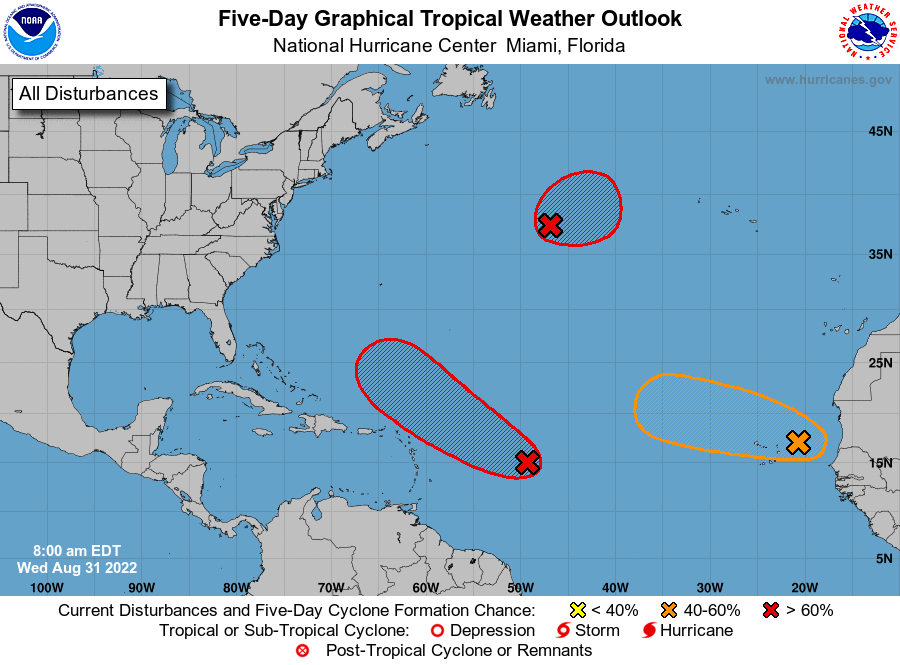
Although, look at what other years had this too. 1961 and 1997. One was a very active year (cool neutral too), the other was not (duh, a Super El Nino is to blame :D ). Not much of a reliable pattern here. Now September is going to be a month to watch. It remains to be seen if September all of a sudden turns more favorable and makes up for the lack of activity in August, but we do know that it's somewhat likely that we could even see 3 NSs form by this next month's start, with 91L, the 20/40 wave, and the subtropical thing. There are also some rumblings of what could be a longer-tracking system by later next week, so we'll have to wait and see.

Under normal circumstances and by logic, September should really demonstrate, this year (as it does nearly every other year), why it's the peak month and why "September Remember." In fact, sometimes I actually want to see a hypothetical what-if scenario where the Storm2k members were tracking the 1961 hurricane season. I could only imagine how season-cancelish that would have been even on the last day of August :lol: .
0 likes   
Unless explicitly stated, all info in my posts is based on my own opinions and observations. Tropical storms and hurricanes can be extremely dangerous. Do not think you can beat Mother Nature. Refer to an accredited weather research agency or meteorologist if you need to make serious decisions regarding an approaching storm.

User avatar
Teban54
Category 5
Category 5
Posts: 3204
Joined: Sat May 19, 2018 1:19 pm

Re: 2022 Indicators (SSTs/SAL/MSLP/Shear/Steering/Instability) and >Day 16 Models

#3286 Postby Teban54 » Wed Aug 31, 2022 8:45 am

Fruit basket:
Image
5 likes   

User avatar
Iceresistance
Category 5
Category 5
Posts: 9288
Age: 21
Joined: Sat Oct 10, 2020 9:45 am
Location: Tecumseh, OK/Norman, OK

Re: 2022 Indicators (SSTs/SAL/MSLP/Shear/Steering/Instability) and >Day 16 Models

#3287 Postby Iceresistance » Wed Aug 31, 2022 9:43 am

1 likes   
Bill 2015 & Beta 2020

Winter 2020-2021 :cold:

All observations are in Tecumseh, OK unless otherwise noted.

Winter posts are focused mainly for Oklahoma & Texas.

Take any of my forecasts with a grain of salt, refer to the NWS, SPC, and NHC for official information

Never say Never with weather! Because ANYTHING is possible!

User avatar
WiscoWx02
Category 1
Category 1
Posts: 391
Joined: Sat Jul 31, 2021 8:09 pm

Re: 2022 Indicators (SSTs/SAL/MSLP/Shear/Steering/Instability) and >Day 16 Models

#3288 Postby WiscoWx02 » Wed Aug 31, 2022 10:25 am


The subtropics are probably the biggest threat to the whole bust season idea. 93L may be August's saving grace for having a named storm. I suppose now that the subtropics door has opened more may follow.
1 likes   

User avatar
SFLcane
S2K Supporter
S2K Supporter
Posts: 10163
Age: 47
Joined: Sat Jun 05, 2010 1:44 pm
Location: Lake Worth Florida

Re: 2022 Indicators (SSTs/SAL/MSLP/Shear/Steering/Instability) and >Day 16 Models

#3289 Postby SFLcane » Wed Aug 31, 2022 12:54 pm

Going to post this here as this is VERY important as we enter September with more CV storms potentially coming.

 https://twitter.com/AndyHazelton/status/1565032856849731584


1 likes   

User avatar
Iceresistance
Category 5
Category 5
Posts: 9288
Age: 21
Joined: Sat Oct 10, 2020 9:45 am
Location: Tecumseh, OK/Norman, OK

Re: 2022 Indicators (SSTs/SAL/MSLP/Shear/Steering/Instability) and >Day 16 Models

#3290 Postby Iceresistance » Wed Aug 31, 2022 1:03 pm

SFLcane wrote:Going to post this here as this is VERY important as we enter September with more CV storms potentially coming.

https://twitter.com/AndyHazelton/status/1565032856849731584?s=20&t=QWV229gdKqXJzxOKsomNWw


I forget, more intense storms with a pattern breakage or enhance the TUTT?
0 likes   
Bill 2015 & Beta 2020

Winter 2020-2021 :cold:

All observations are in Tecumseh, OK unless otherwise noted.

Winter posts are focused mainly for Oklahoma & Texas.

Take any of my forecasts with a grain of salt, refer to the NWS, SPC, and NHC for official information

Never say Never with weather! Because ANYTHING is possible!

MHC Tracking
Tropical Storm
Tropical Storm
Posts: 195
Joined: Mon Mar 15, 2021 10:05 am

Re: 2022 Indicators (SSTs/SAL/MSLP/Shear/Steering/Instability) and >Day 16 Models

#3291 Postby MHC Tracking » Wed Aug 31, 2022 4:27 pm

2013 not a good analogue imo. 2013 had weak, short lived storm 2spam" in the MDR with lots of pitiful dry air choked stuff. However, the subtropical warmth which caused so many issues in 2013 is even more prevalent in 2022, so I can see where the analogue idea comes from. Perhaps 1994/1962/1987 are better analogues in terms of activity
0 likes   

User avatar
skyline385
Category 5
Category 5
Posts: 2728
Age: 35
Joined: Wed Aug 26, 2020 11:15 pm
Location: Houston TX

Re: 2022 Indicators (SSTs/SAL/MSLP/Shear/Steering/Instability) and >Day 16 Models

#3292 Postby skyline385 » Wed Aug 31, 2022 4:58 pm

7 likes   

Visioen
S2K Supporter
S2K Supporter
Posts: 286
Joined: Sat Sep 02, 2017 2:08 pm
Location: Belgium, Europe

Re: 2022 Indicators (SSTs/SAL/MSLP/Shear/Steering/Instability) and >Day 16 Models

#3293 Postby Visioen » Wed Aug 31, 2022 6:47 pm


It is the GFS laughing at us mortals trying to make sense of the tropical Atlantic.
5 likes   

MarioProtVI
Category 4
Category 4
Posts: 935
Age: 24
Joined: Sun Sep 29, 2019 7:33 pm
Location: New Jersey

Re: 2022 Indicators (SSTs/SAL/MSLP/Shear/Steering/Instability) and >Day 16 Models

#3294 Postby MarioProtVI » Wed Aug 31, 2022 6:55 pm

MHC Tracking wrote:2013 not a good analogue imo. 2013 had weak, short lived storm 2spam" in the MDR with lots of pitiful dry air choked stuff. However, the subtropical warmth which caused so many issues in 2013 is even more prevalent in 2022, so I can see where the analogue idea comes from. Perhaps 1994/1962/1987 are better analogues in terms of activity

Someone said it looks identical to where 2018 was rn. Perhaps a similar analog?
2 likes   

User avatar
ElectricStorm
Category 5
Category 5
Posts: 5044
Age: 24
Joined: Tue Aug 13, 2019 11:23 pm
Location: Skiatook, OK / Norman, OK

Re: 2022 Indicators (SSTs/SAL/MSLP/Shear/Steering/Instability) and >Day 16 Models

#3295 Postby ElectricStorm » Wed Aug 31, 2022 7:06 pm

It's now past 0z so we officially had a 0 NS August! Unreal
5 likes   
B.S Meteorology, University of Oklahoma '25

Please refer to the NHC, NWS, or SPC for official information.

User avatar
WiscoWx02
Category 1
Category 1
Posts: 391
Joined: Sat Jul 31, 2021 8:09 pm

Re: 2022 Indicators (SSTs/SAL/MSLP/Shear/Steering/Instability) and >Day 16 Models

#3296 Postby WiscoWx02 » Wed Aug 31, 2022 7:39 pm

ElectricStorm wrote:It's now past 0z so we officially had a 0 NS August! Unreal


Right?!? Never thought I’d see the year it would happen but here we are…maybe September will be different? :) We’ll see at least see one for sure IMO
Last edited by WiscoWx02 on Wed Aug 31, 2022 7:42 pm, edited 1 time in total.
0 likes   

User avatar
CyclonicFury
Category 5
Category 5
Posts: 2025
Age: 26
Joined: Sun Jul 02, 2017 12:32 pm
Location: NC
Contact:

Re: 2022 Indicators (SSTs/SAL/MSLP/Shear/Steering/Instability) and >Day 16 Models

#3297 Postby CyclonicFury » Wed Aug 31, 2022 7:42 pm

WiscoWx02 wrote:
ElectricStorm wrote:It's now past 0z so we officially had a 0 NS August! Unreal


Right?!? Never thought I’d see the year it would happen but here we are…maybe September will be different? :) We’ll at least see one for sure IMO

September will probably have several. I wouldn't be shocked if 93L forms tomorrow and 91L could form at any time over the next few days. After that, I think we'll see a couple MDR storms during the month and maybe a storm or two elsewhere.
4 likes   
NCSU B.S. in Meteorology Class of 2021. Tropical weather blogger at http://www.cyclonicfury.com. My forecasts and thoughts are NOT official, for official forecasts please consult the National Hurricane Center.

User avatar
chaser1
S2K Supporter
S2K Supporter
Posts: 5464
Age: 64
Joined: Sat Oct 15, 2005 5:59 pm
Location: Longwood, Fl

Re: 2022 Indicators (SSTs/SAL/MSLP/Shear/Steering/Instability) and >Day 16 Models

#3298 Postby chaser1 » Wed Aug 31, 2022 9:37 pm

"......in other news this evening, US officials pan the thousands of reported UFO sightings over the tropical Atlantic this past month. Senior advisors claim the reported lights were actually a fleet of cloud-seeding Monsanto drones testing the affects of RoundUp on budding tropical disturbances this season. Renown tropical weather prognosticators were contacted regarding the potential impact to the season's Hurricane Season. Thus far all have declined to comment....".
3 likes   
Andy D

(For official information, please refer to the NHC and NWS products.)

User avatar
chaser1
S2K Supporter
S2K Supporter
Posts: 5464
Age: 64
Joined: Sat Oct 15, 2005 5:59 pm
Location: Longwood, Fl

Re: 2022 Indicators (SSTs/SAL/MSLP/Shear/Steering/Instability) and >Day 16 Models

#3299 Postby chaser1 » Wed Aug 31, 2022 9:40 pm

Wait, WHAT? Well then, in light of THAT news.... i'm requesting to lower my May Contest guess of a season having 23/13/7 (Final), to 22/12/6 instead :ggreen:
0 likes   
Andy D

(For official information, please refer to the NHC and NWS products.)

User avatar
skyline385
Category 5
Category 5
Posts: 2728
Age: 35
Joined: Wed Aug 26, 2020 11:15 pm
Location: Houston TX

Re: 2022 Indicators (SSTs/SAL/MSLP/Shear/Steering/Instability) and >Day 16 Models

#3300 Postby skyline385 » Wed Aug 31, 2022 10:49 pm

Really puts into perspective this slow start, it is also hilarious how the only season to have a slower start since 1951 is 1988 with Gilbert :D

 https://twitter.com/splillo/status/1565006485041516544


 https://twitter.com/WxTca/status/1565033543788425216


Last edited by skyline385 on Wed Aug 31, 2022 10:55 pm, edited 2 times in total.
0 likes   


Return to “Talkin' Tropics”

Who is online

Users browsing this forum: abajan, Stratton23 and 38 guests