ATL: DANIELLE - Post-Tropical - Discussion
Moderator: S2k Moderators
-
Kingarabian

- S2K Supporter

- Posts: 16373
- Joined: Sat Aug 08, 2009 3:06 am
- Location: Honolulu, Hawaii
Re: ATL: DANIELLE - Tropical Storm - Discussion
Probably a lot of revising in the off season.
4 likes
RIP Kobe Bryant
-
Jelmergraaff
- Tropical Storm

- Posts: 138
- Age: 23
- Joined: Fri Aug 27, 2021 1:00 pm
- Location: The Netherlands
Re: ATL: DANIELLE - Tropical Storm - Discussion
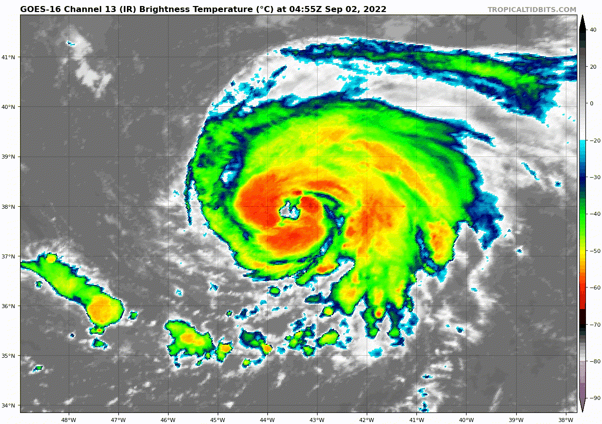
Honestly - if what I see on satellite imagery is a real eye - this 'storm' should at least be a cat. 1 hurricane.
3 likes
21-year old meteorologist and student MSc Climate Studies from The Netherlands. Interested in all fields of meteorology and climatology, including tropical systems like hurricanes.
-
Yellow Evan

- Professional-Met

- Posts: 16242
- Age: 27
- Joined: Fri Jul 15, 2011 12:48 pm
- Location: Henderson, Nevada/Honolulu, HI
- Contact:
Re: ATL: DANIELLE - Tropical Storm - Discussion
TXNT21 KNES 020621
TCSNTL
A. 05L (DANIELLE)
B. 02/0530Z
C. 37.9N
D. 43.6W
E. ONE/GOES-E
F. T4.5/4.5
G. IR/EIR/SWIR
H. REMARKS...A WMG EYE SURROUNDED BY A MG RING AND EMBEDDED IN MG RESULTS
IN A DT OF 4.5. 6 HOUR AVERAGING ALSO RESULTED IN A DT OF 4.5. THE MET
IS 3.0 BASED ON A 24 HR RAPID DEVELOPING TREND. THE PT IS 3.5. THE FT IS
BASED ON THE 6 HOUR AVERAGE DT WHICH JUSTIFIES BREAKING THE CONTRAINTS
LIMITING THE FT TO A CHANGE IN 1.0 OVER 6 HOURS.
I. ADDL POSITIONS
NIL
...GATLING
0 likes
-
galaxy401

- Category 5

- Posts: 2446
- Age: 30
- Joined: Sat Aug 25, 2012 9:04 pm
- Location: Casa Grande, Arizona
Re: ATL: DANIELLE - Tropical Storm - Discussion
I think the NHC will jump to hurricane status next advisory. That 4.5 reading might decide it.
0 likes
Got my eyes on moving right into Hurricane Alley: Florida.
-
Sciencerocks
- Category 5
- Posts: 10186
- Age: 40
- Joined: Thu Jul 06, 2017 1:51 am
-
Jelmergraaff
- Tropical Storm
- Posts: 138
- Age: 23
- Joined: Fri Aug 27, 2021 1:00 pm
- Location: The Netherlands
Re: ATL: DANIELLE - Tropical Storm - Discussion
NHC has put it at 70 mph for now.
Satellite imagery shows that Danielle is continuing to strengthen, with convective bands wrapping around the center and attempts at eye formation. The various satellite intensity estimates have a wide range from 45-77 kt, and the consensus of the estimates is that Danielle is not quite a hurricane yet. Based on these estimates, the initial intensity is increased to a possibly conservative 60 kt.
1 likes
21-year old meteorologist and student MSc Climate Studies from The Netherlands. Interested in all fields of meteorology and climatology, including tropical systems like hurricanes.

Re: ATL: DANIELLE - Tropical Storm - Discussion
60kt. I don't normally support criticizing NHC decisions, but
Clearly the 45kt one is wrong and it makes absolutely no sense to factor that into the average especially since they tossed it out in the earlier advisory. Automated Dvorak measurements need to be discontinued.
The various satellite intensity estimates have a
wide range from 45-77 kt, and the consensus of the estimates is
that Danielle is not quite a hurricane yet.
Clearly the 45kt one is wrong and it makes absolutely no sense to factor that into the average especially since they tossed it out in the earlier advisory. Automated Dvorak measurements need to be discontinued.
6 likes
The above post is not official and should not be used as such. It is the opinion of the poster and may or may not be backed by sound meteorological data. It is not endorsed by any professional institution or storm2k.org. For official information, please refer to the NHC and NWS products.

Re: ATL: DANIELLE - Tropical Storm - Discussion
Hammy wrote:60kt. I don't normally support criticizing NHC decisions, butThe various satellite intensity estimates have a
wide range from 45-77 kt, and the consensus of the estimates is
that Danielle is not quite a hurricane yet.
Clearly the 45kt one is wrong and it makes absolutely no sense to factor that into the average especially since they tossed it out in the earlier advisory. Automated Dvorak measurements need to be discontinued.
ADT is usually pretty good…except when you’re dealing with high latitude systems. Even the manual Dvorak fix was better, and those are infamous for sometimes being awful.
1 likes
Irene '11 Sandy '12 Hermine '16 5/15/2018 Derecho Fay '20 Isaias '20 Elsa '21 Henri '21 Ida '21
I am only a meteorology enthusiast who knows a decent amount about tropical cyclones. Look to the professional mets, the NHC, or your local weather office for the best information.
I am only a meteorology enthusiast who knows a decent amount about tropical cyclones. Look to the professional mets, the NHC, or your local weather office for the best information.
-
wxman57

- Moderator-Pro Met

- Posts: 23175
- Age: 68
- Joined: Sat Jun 21, 2003 8:06 pm
- Location: Houston, TX (southwest)
Re: ATL: DANIELLE - Tropical Storm - Discussion
galaxy401 wrote:I think the NHC will jump to hurricane status next advisory. That 4.5 reading might decide it.
That Dvorak 4.5 was available before they issued the advisory at 09Z. Why would they not upgrade a system with an eye to a hurricane? Being "conservative"? It's a hurricane now, no doubt. May be a major hurricane later today, though it's only predicted to reach 70 kts in the next 24 hours. I think it's 70 kts now. Falling farther behind the power curve...
4 likes
-
Iceresistance

- Category 5
- Posts: 9598
- Age: 22
- Joined: Sat Oct 10, 2020 9:45 am
- Location: Tecumseh, OK/Norman, OK
Re: ATL: DANIELLE - Tropical Storm - Discussion
Will be upgraded to a hurricane later today
https://twitter.com/MJVentrice/status/1565653396329320450
https://twitter.com/MJVentrice/status/1565653396329320450
1 likes
Bill 2015 & Beta 2020
Winter 2020-2021
All observations are in Tecumseh, OK unless otherwise noted.
Winter posts are focused mainly for Oklahoma & Texas.
Take any of my forecasts with a grain of salt, refer to the NWS, SPC, and NHC for official information
Never say Never with weather! Because ANYTHING is possible!
Winter 2020-2021
All observations are in Tecumseh, OK unless otherwise noted.
Winter posts are focused mainly for Oklahoma & Texas.
Take any of my forecasts with a grain of salt, refer to the NWS, SPC, and NHC for official information
Never say Never with weather! Because ANYTHING is possible!
-
tolakram
- Admin

- Posts: 20186
- Age: 62
- Joined: Sun Aug 27, 2006 8:23 pm
- Location: Florence, KY (name is Mark)
Re: ATL: DANIELLE - Tropical Storm - Discussion
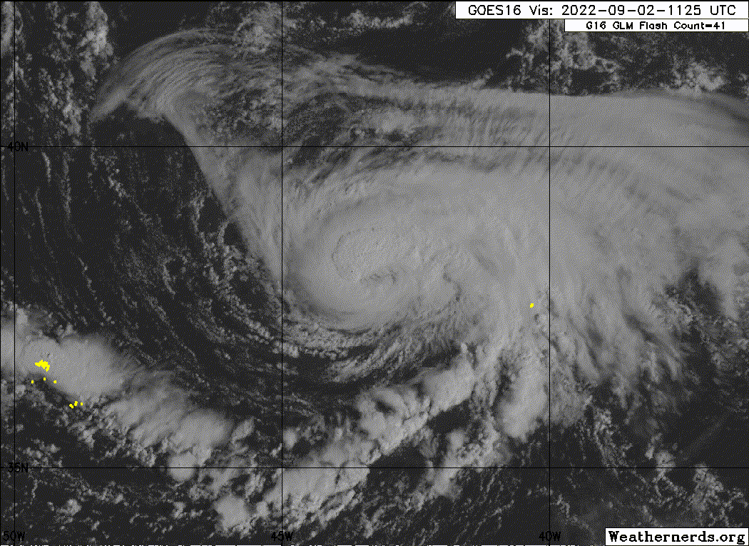
Floater on it.
https://weather.cod.edu/satrad/?parms=meso-meso2-02-200-0-100-1&checked=map&colorbar=undefined
SLIDER version
https://rammb-slider.cira.colostate.edu/?sat=goes-16&sec=mesoscale_02&x=954&y=981&z=2&angle=0&im=12&ts=1&st=0&et=0&speed=130&motion=loop&maps%5Bborders%5D=white&lat=0&p%5B0%5D=band_02&opacity%5B0%5D=1&pause=0&slider=-1&hide_controls=0&mouse_draw=0&follow_feature=0&follow_hide=0&s=rammb-slider&draw_color=FFD700&draw_width=6
0 likes
M a r k
- - - - -
Join us in chat: Storm2K Chatroom Invite. Android and IOS apps also available.
The posts in this forum are NOT official forecasts and should not be used as such. Posts are NOT endorsed by any professional institution or STORM2K.org. For official information and forecasts, please refer to NHC and NWS products.
-
cycloneye

- Admin
- Posts: 149550
- Age: 69
- Joined: Thu Oct 10, 2002 10:54 am
- Location: San Juan, Puerto Rico
Re: ATL: DANIELLE - Tropical Storm - Discussion
Hurricane on next advisory.
https://ftp.nhc.noaa.gov/atcf/btk/bal052022.dat
AL, 05, 2022090212, , BEST, 0, 380N, 432W, 65, 992, HU
https://ftp.nhc.noaa.gov/atcf/btk/bal052022.dat
1 likes
Visit the Caribbean-Central America Weather Thread where you can find at first post web cams,radars
and observations from Caribbean basin members Click Here
and observations from Caribbean basin members Click Here
-
Hypercane_Kyle

- Category 5
- Posts: 3465
- Joined: Sat Mar 07, 2015 7:58 pm
- Location: Cape Canaveral, FL
Re: ATL: DANIELLE - Tropical Storm - Discussion
Best track is 65 knots.
Code: Select all
Hurricane DANIELLE
As of 12:00 UTC Sep 02, 2022:

Location: 38.0°N 43.2°W
Maximum Winds: 65 kt  Gusts: N/A
Minimum Central Pressure: 992 mb
Environmental Pressure: N/A
Radius of Circulation: N/A
Radius of Maximum wind: 15 nm
64 kt Wind Radii by Quadrant:
1 likes
My posts are my own personal opinion, defer to the National Hurricane Center (NHC) and other NOAA products for decision making during hurricane season.
-
TallyTracker
- Category 2

- Posts: 787
- Joined: Thu Oct 11, 2018 2:46 pm
Re: ATL: DANIELLE - Tropical Storm - Discussion
Danielle is looking like more borderline Cat1/Cat2 with the deeper convection developing. There does appear to be a dry slot eroding the east side of the eye. Once that’s worked out later today, I expect a Cat 3 is not out of the question.
0 likes
Fran '96, Georges '98, Gordon '00, Gabrielle '01, Charley '04, Frances '04, Jeanne '04, Barry '07, Fay '08, Debby '12, Matthew '16, Emily '17, Irma '17, Michael ‘18, Elsa ‘21, Fred ‘21, Mindy ‘21, Nicole ‘22, Idalia ‘23, Debby ‘24, Helene ‘24
Re: ATL: DANIELLE - Tropical Storm - Discussion
TallyTracker wrote:Danielle is looking like more borderline Cat1/Cat2 with the deeper convection developing. There does appear to be a dry slot eroding the east side of the eye. Once that’s worked out later today, I expect a Cat 3 is not out of the question.
The question is whether or not the NHC will even recognize Cat 3 Danielle as a Cat 3 without recon. They’ve already been way too conservative with it.
4 likes
Irene '11 Sandy '12 Hermine '16 5/15/2018 Derecho Fay '20 Isaias '20 Elsa '21 Henri '21 Ida '21
I am only a meteorology enthusiast who knows a decent amount about tropical cyclones. Look to the professional mets, the NHC, or your local weather office for the best information.
I am only a meteorology enthusiast who knows a decent amount about tropical cyclones. Look to the professional mets, the NHC, or your local weather office for the best information.
-
Iceresistance
- Category 5
- Posts: 9598
- Age: 22
- Joined: Sat Oct 10, 2020 9:45 am
- Location: Tecumseh, OK/Norman, OK
Re: ATL: DANIELLE - Tropical Storm - Discussion
aspen wrote:TallyTracker wrote:Danielle is looking like more borderline Cat1/Cat2 with the deeper convection developing. There does appear to be a dry slot eroding the east side of the eye. Once that’s worked out later today, I expect a Cat 3 is not out of the question.
The question is whether or not the NHC will even recognize Cat 3 Danielle as a Cat 3 without recon. They’ve already been way too conservative with it.
They have done it before, but it must maintain a strong inner core with a clear eye for some period of time,and the satellite intensity estimates must also be consistent for a CAT 3 as well.
0 likes
Bill 2015 & Beta 2020
Winter 2020-2021
All observations are in Tecumseh, OK unless otherwise noted.
Winter posts are focused mainly for Oklahoma & Texas.
Take any of my forecasts with a grain of salt, refer to the NWS, SPC, and NHC for official information
Never say Never with weather! Because ANYTHING is possible!
Winter 2020-2021
All observations are in Tecumseh, OK unless otherwise noted.
Winter posts are focused mainly for Oklahoma & Texas.
Take any of my forecasts with a grain of salt, refer to the NWS, SPC, and NHC for official information
Never say Never with weather! Because ANYTHING is possible!
-
Iceresistance
- Category 5
- Posts: 9598
- Age: 22
- Joined: Sat Oct 10, 2020 9:45 am
- Location: Tecumseh, OK/Norman, OK
Re: ATL: DANIELLE - Tropical Storm - Discussion
ASCAT has clipped the eastern side of the system, there are a lot of 50 knot barbs near the CoC.
1 likes
Bill 2015 & Beta 2020
Winter 2020-2021
All observations are in Tecumseh, OK unless otherwise noted.
Winter posts are focused mainly for Oklahoma & Texas.
Take any of my forecasts with a grain of salt, refer to the NWS, SPC, and NHC for official information
Never say Never with weather! Because ANYTHING is possible!
Winter 2020-2021
All observations are in Tecumseh, OK unless otherwise noted.
Winter posts are focused mainly for Oklahoma & Texas.
Take any of my forecasts with a grain of salt, refer to the NWS, SPC, and NHC for official information
Never say Never with weather! Because ANYTHING is possible!

Re: ATL: DANIELLE - Hurricane - Discussion
Now officially the first Atlantic hurricane of the season.
ZCZC MIATCDAT5 ALL
TTAA00 KNHC DDHHMM
Hurricane Danielle Discussion Number 6
NWS National Hurricane Center Miami FL AL052022
300 PM GMT Fri Sep 02 2022
Danielle has continued to strengthen this morning. A ragged eye is
evident in conventional satellite imagery, and deep convection
surrounds much of the northern and western portions of the
circulation. A recent ASCAT-B pass missed the center but caught the
eastern portion of the circulation. It showed winds up to 52 kt on
the inner edge of the swath and tropical-storm-force winds extending
outward up to 100 n mi in the northeastern quadrant of the cyclone.
The latest objective and subjective satellite estimates support
raising the initial intensity to 65 kt, which makes Danielle the
first Atlantic hurricane of the season.
Atmospheric and oceanic conditions appear generally favorable for
some additional strengthening during the next couple of days. The
hurricane will meander over 27C SSTs in an environment of light to
moderate deep-layer shear. Danielle is a higher-latitude storm, and
so there is the potential for some mid-level dry air entrainment
that could briefly disrupt the cyclone's organization. The latest
intensity guidance consensus still favors some additional
strengthening through Sunday. The official NHC forecast is similar
to the previous one and lies slightly above the model consensus.
After 72 h, weakening is expected to commence as Danielle gains
latitude and moves over cooler waters while it encounters more
deep-layer shear within the mid-latitude westerlies.
Although the 12-hr motion of Danielle has been an easterly drift,
the hurricane appears to have become nearly stationary this
morning. The cyclone will likely continue to meander over the
central Atlantic during the next couple of days under the influence
of a blocking high pressure ridge. This feature is forecast to
weaken by early next week, which should allow Danielle to begin
moving northeastward by 72 h and accelerate deeper into the
mid-latitudes on days 4-5. Once again, it appears Danielle will not
begin extratropical transition until beyond the end of the forecast
period. The NHC track forecast generally lies near the center of
the guidance envelope, close to the reliable consensus aids.
FORECAST POSITIONS AND MAX WINDS
INIT 02/1500Z 37.9N 43.3W 65 KT 75 MPH
12H 03/0000Z 38.0N 43.3W 70 KT 80 MPH
24H 03/1200Z 38.1N 43.5W 75 KT 85 MPH
36H 04/0000Z 38.1N 44.0W 80 KT 90 MPH
48H 04/1200Z 38.5N 44.4W 85 KT 100 MPH
60H 05/0000Z 38.9N 44.1W 85 KT 100 MPH
72H 05/1200Z 39.6N 43.1W 85 KT 100 MPH
96H 06/1200Z 41.0N 40.5W 80 KT 90 MPH
120H 07/1200Z 42.5N 36.4W 70 KT 80 MPH
$$
Forecaster Reinhart
NNNN
3 likes
-
Sciencerocks
- Category 5
- Posts: 10186
- Age: 40
- Joined: Thu Jul 06, 2017 1:51 am
-
Iceresistance
- Category 5
- Posts: 9598
- Age: 22
- Joined: Sat Oct 10, 2020 9:45 am
- Location: Tecumseh, OK/Norman, OK
Re: ATL: DANIELLE - Hurricane - Discussion

7 likes
Bill 2015 & Beta 2020
Winter 2020-2021
All observations are in Tecumseh, OK unless otherwise noted.
Winter posts are focused mainly for Oklahoma & Texas.
Take any of my forecasts with a grain of salt, refer to the NWS, SPC, and NHC for official information
Never say Never with weather! Because ANYTHING is possible!
Winter 2020-2021
All observations are in Tecumseh, OK unless otherwise noted.
Winter posts are focused mainly for Oklahoma & Texas.
Take any of my forecasts with a grain of salt, refer to the NWS, SPC, and NHC for official information
Never say Never with weather! Because ANYTHING is possible!
Who is online
Users browsing this forum: No registered users and 14 guests