ATL: DANIELLE - Post-Tropical - Discussion
Moderator: S2k Moderators


Re: ATL: DANIELLE - Hurricane - Discussion
So how long is Danielle going to have to sit in the same spot for upwelling to become an issue? I'm assuming the decrease in convection as of the last few hours is probably due to dry air entrainment but a question I have nonetheless.
3 likes
-
cycloneye

- Admin

- Posts: 149727
- Age: 69
- Joined: Thu Oct 10, 2002 10:54 am
- Location: San Juan, Puerto Rico
Re: ATL: DANIELLE - Hurricane - Discussion
AL, 05, 2022090218, , BEST, 0, 379N, 435W, 65, 992, HU
https://ftp.nhc.noaa.gov/atcf/btk/bal052022.dat
0 likes
Visit the Caribbean-Central America Weather Thread where you can find at first post web cams,radars
and observations from Caribbean basin members Click Here
and observations from Caribbean basin members Click Here
-
Sciencerocks
- Category 5

- Posts: 10193
- Age: 40
- Joined: Thu Jul 06, 2017 1:51 am


Re: ATL: DANIELLE - Hurricane - Discussion
WiscoWx02 wrote:So how long is Danielle going to have to sit in the same spot for upwelling to become an issue? I'm assuming the decrease in convection as of the last few hours is probably due to dry air entrainment but a question I have nonetheless.
Models have this sitting and intensifying place, but I hadn't even considered the upwelling problem which makes me wonder if the models are even factoring that in, given all show steady-to-quick intensification.
1 likes
The above post is not official and should not be used as such. It is the opinion of the poster and may or may not be backed by sound meteorological data. It is not endorsed by any professional institution or storm2k.org. For official information, please refer to the NHC and NWS products.

Re: ATL: DANIELLE - Hurricane - Discussion
Hammy wrote:WiscoWx02 wrote:So how long is Danielle going to have to sit in the same spot for upwelling to become an issue? I'm assuming the decrease in convection as of the last few hours is probably due to dry air entrainment but a question I have nonetheless.
Models have this sitting and intensifying place, but I hadn't even considered the upwelling problem which makes me wonder if the models are even factoring that in, given all show steady-to-quick intensification.
It would be strange if they haven’t, especially the hurricane models, because the HWRF has constantly been factoring in upwelling with its stall-and-recurve scenarios for 91L.
0 likes
Irene '11 Sandy '12 Hermine '16 5/15/2018 Derecho Fay '20 Isaias '20 Elsa '21 Henri '21 Ida '21
I am only a meteorology enthusiast who knows a decent amount about tropical cyclones. Look to the professional mets, the NHC, or your local weather office for the best information.
I am only a meteorology enthusiast who knows a decent amount about tropical cyclones. Look to the professional mets, the NHC, or your local weather office for the best information.
-
galaxy401

- Category 5
- Posts: 2446
- Age: 30
- Joined: Sat Aug 25, 2012 9:04 pm
- Location: Casa Grande, Arizona
Re: ATL: DANIELLE - Hurricane - Discussion
NHC dropped the intensity forecast quite a bit. No longer forecasting a Category 2.
1 likes
Got my eyes on moving right into Hurricane Alley: Florida.
-
SconnieCane
- Category 5
- Posts: 1013
- Joined: Thu Aug 02, 2018 5:29 pm
- Location: Madison, WI
Re: ATL: DANIELLE - Hurricane - Discussion
galaxy401 wrote:NHC dropped the intensity forecast quite a bit. No longer forecasting a Category 2.
What a shocker in 2022.
3 likes
Re: ATL: DANIELLE - Hurricane - Discussion
galaxy401 wrote:NHC dropped the intensity forecast quite a bit. No longer forecasting a Category 2.
Intensity will probably depend on how much it moves in the next few days. If it inches away from where it’s been stalling, it could take off again over untapped waters.
1 likes
Irene '11 Sandy '12 Hermine '16 5/15/2018 Derecho Fay '20 Isaias '20 Elsa '21 Henri '21 Ida '21
I am only a meteorology enthusiast who knows a decent amount about tropical cyclones. Look to the professional mets, the NHC, or your local weather office for the best information.
I am only a meteorology enthusiast who knows a decent amount about tropical cyclones. Look to the professional mets, the NHC, or your local weather office for the best information.
-
cycloneye
- Admin
- Posts: 149727
- Age: 69
- Joined: Thu Oct 10, 2002 10:54 am
- Location: San Juan, Puerto Rico
Re: ATL: DANIELLE - Hurricane - Discussion
Still at 65kt.
https://ftp.nhc.noaa.gov/atcf/btk/bal052022.dat
AL, 05, 2022090300, , BEST, 0, 379N, 434W, 65, 988, HU
https://ftp.nhc.noaa.gov/atcf/btk/bal052022.dat
0 likes
Visit the Caribbean-Central America Weather Thread where you can find at first post web cams,radars
and observations from Caribbean basin members Click Here
and observations from Caribbean basin members Click Here

Re: ATL: DANIELLE - Hurricane - Discussion
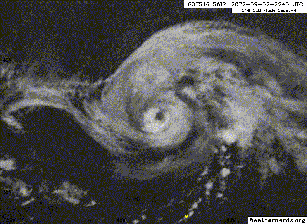
IMO, this likely reached an initial peak stronger than 65 kt and has weakened a bit due to upwelling.
6 likes
TC naming lists: retirements and intensity
Most aggressive Advisory #1's in North Atlantic (cr. kevin for starting the list)
Most aggressive Advisory #1's in North Atlantic (cr. kevin for starting the list)
-
Sciencerocks
- Category 5
- Posts: 10193
- Age: 40
- Joined: Thu Jul 06, 2017 1:51 am
-
cycloneye
- Admin
- Posts: 149727
- Age: 69
- Joined: Thu Oct 10, 2002 10:54 am
- Location: San Juan, Puerto Rico
Re: ATL: DANIELLE - Tropical Storm - Discussion
Has underperformed bigtime as the forecast was to reach cat 2 but the upwelling has taken a toll.
1 likes
Visit the Caribbean-Central America Weather Thread where you can find at first post web cams,radars
and observations from Caribbean basin members Click Here
and observations from Caribbean basin members Click Here
Re: ATL: DANIELLE - Tropical Storm - Discussion
Looks like it’s trying to form a giant eye, like the HWRF has suggested in a couple of runs.
0 likes
Irene '11 Sandy '12 Hermine '16 5/15/2018 Derecho Fay '20 Isaias '20 Elsa '21 Henri '21 Ida '21
I am only a meteorology enthusiast who knows a decent amount about tropical cyclones. Look to the professional mets, the NHC, or your local weather office for the best information.
I am only a meteorology enthusiast who knows a decent amount about tropical cyclones. Look to the professional mets, the NHC, or your local weather office for the best information.
-
cycloneye
- Admin
- Posts: 149727
- Age: 69
- Joined: Thu Oct 10, 2002 10:54 am
- Location: San Juan, Puerto Rico
Re: ATL: DANIELLE - Tropical Storm - Discussion
AL, 05, 2022090312, , BEST, 0, 381N, 439W, 60, 990, TS
https://ftp.nhc.noaa.gov/atcf/btk/bal052022.dat
0 likes
Visit the Caribbean-Central America Weather Thread where you can find at first post web cams,radars
and observations from Caribbean basin members Click Here
and observations from Caribbean basin members Click Here
Re: ATL: DANIELLE - Tropical Storm - Discussion
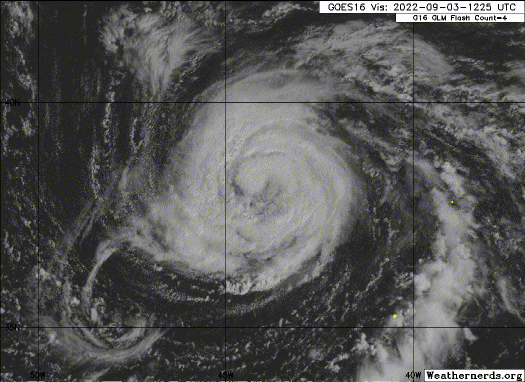
Seems to still be mixing out some dry air and getting its core back in shape, but overall Danielle has improved since its somewhat anemic appearance last night. It should be on its way to becoming a hurricane later today, and probably still has a shot at becoming a Cat 2.

2 likes
Irene '11 Sandy '12 Hermine '16 5/15/2018 Derecho Fay '20 Isaias '20 Elsa '21 Henri '21 Ida '21
I am only a meteorology enthusiast who knows a decent amount about tropical cyclones. Look to the professional mets, the NHC, or your local weather office for the best information.
I am only a meteorology enthusiast who knows a decent amount about tropical cyclones. Look to the professional mets, the NHC, or your local weather office for the best information.
-
tolakram
- Admin
- Posts: 20186
- Age: 62
- Joined: Sun Aug 27, 2006 8:23 pm
- Location: Florence, KY (name is Mark)
Re: ATL: DANIELLE - Tropical Storm - Discussion
aspen wrote:Seems to still be mixing out some dry air and getting its core back in shape, but overall Danielle has improved since its somewhat anemic appearance last night. It should be on its way to becoming a hurricane later today, and probably still has a shot at becoming a Cat 2.
https://i.imgur.com/fGnwNRX.jpg
The problem is that these above normal water temps are shallow, so upwelling is a much bigger deal IMO. Tough intensity forecast. If it moves enough it can get stronger, too slow and much weaker. There is almost no ocean heat content, the above normal water temps are due to lack of winds in the area.
A good source: http://rammb-data.cira.colostate.edu/tc_realtime/
Use archive to see an OHC chart that is filled out.

0 likes
M a r k
- - - - -
Join us in chat: Storm2K Chatroom Invite. Android and IOS apps also available.
The posts in this forum are NOT official forecasts and should not be used as such. Posts are NOT endorsed by any professional institution or STORM2K.org. For official information and forecasts, please refer to NHC and NWS products.
-
NotSparta

- Professional-Met

- Posts: 1677
- Age: 24
- Joined: Fri Aug 18, 2017 8:24 am
- Location: Naples, FL
- Contact:
Re: ATL: DANIELLE - Tropical Storm - Discussion
tolakram wrote:aspen wrote:Seems to still be mixing out some dry air and getting its core back in shape, but overall Danielle has improved since its somewhat anemic appearance last night. It should be on its way to becoming a hurricane later today, and probably still has a shot at becoming a Cat 2.
https://i.imgur.com/fGnwNRX.jpg
The problem is that these above normal water temps are shallow, so upwelling is a much bigger deal IMO. Tough intensity forecast. If it moves enough it can get stronger, too slow and much weaker. There is almost no ocean heat content, the above normal water temps are due to lack of winds in the area.
A good source: http://rammb-data.cira.colostate.edu/tc_realtime/
Use archive to see an OHC chart that is filled out.
https://i.imgur.com/o3mxHvh.png
Seems like the data cuts off at 40N so hard to say how much OHC is there once it gets north
2 likes
This post was probably an opinion of mine, and in no way is official. Please refer to http://www.hurricanes.gov for official tropical analysis and advisories.
My website, with lots of tropical wx graphics, including satellite and recon: http://cyclonicwx.com
My website, with lots of tropical wx graphics, including satellite and recon: http://cyclonicwx.com
-
Sciencerocks
- Category 5
- Posts: 10193
- Age: 40
- Joined: Thu Jul 06, 2017 1:51 am
-
cheezyWXguy

- Category 5
- Posts: 6282
- Joined: Mon Feb 13, 2006 12:29 am
- Location: Dallas, TX
Re: ATL: DANIELLE - Tropical Storm - Discussion
I’d call danielle a hurricane again at this point. Much rounder and starting to get that deep convection back around the core. If these developments continue it should be pretty clear cut by 5pm
3 likes
-
cycloneye
- Admin
- Posts: 149727
- Age: 69
- Joined: Thu Oct 10, 2002 10:54 am
- Location: San Juan, Puerto Rico
Re: ATL: DANIELLE - Tropical Storm - Discussion
AL, 05, 2022090318, , BEST, 0, 380N, 447W, 60, 990, TS
https://ftp.nhc.noaa.gov/atcf/btk/bal052022.dat
0 likes
Visit the Caribbean-Central America Weather Thread where you can find at first post web cams,radars
and observations from Caribbean basin members Click Here
and observations from Caribbean basin members Click Here
Who is online
Users browsing this forum: No registered users and 52 guests