ATL: EARL - Post-Tropical - Discussion

Moderator: S2k Moderators

Message
Author
User avatar
REDHurricane
Category 1
Category 1
Posts: 396
Age: 27
Joined: Sun Jul 03, 2022 2:36 pm
Location: Northeast Pacific Ocean

Re: ATL: EARL - Hurricane - Discussion

#701 Postby REDHurricane » Tue Sep 06, 2022 8:07 pm

Iceresistance wrote:I'm having a hard time believing this, but . . . Is Earl really going on RI or VRI?

https://s1.gifyu.com/images/Dropsonde-24.png


...maybe? Earl is certainly intensifying, but I don't know if that looks like a 975mb structure just yet. It certainly wouldn't surprise me though; Earl has overachieved so far and I could see it eventually reaching high Cat 3/low Cat 4 status as shear subsides over the next few days.

Image
2 likes   

User avatar
Iceresistance
Category 5
Category 5
Posts: 9288
Age: 21
Joined: Sat Oct 10, 2020 9:45 am
Location: Tecumseh, OK/Norman, OK

Re: ATL: EARL - Hurricane - Discussion

#702 Postby Iceresistance » Tue Sep 06, 2022 8:10 pm

InfernoFlameCat wrote:
Iceresistance wrote:I'm having a hard time believing this, but . . . Is Earl really going on RI or VRI?

https://s1.gifyu.com/images/Dropsonde-24.png

975mb? is that a hiccup? that should not be at 975 mb. what!


Eye Dropsonde confirmed the surface pressure at 987 MB, it's likely a hiccup on the dropsonde in the NE eyewall.
1 likes   
Bill 2015 & Beta 2020

Winter 2020-2021 :cold:

All observations are in Tecumseh, OK unless otherwise noted.

Winter posts are focused mainly for Oklahoma & Texas.

Take any of my forecasts with a grain of salt, refer to the NWS, SPC, and NHC for official information

Never say Never with weather! Because ANYTHING is possible!

User avatar
InfernoFlameCat
Category 5
Category 5
Posts: 2102
Age: 22
Joined: Mon Dec 14, 2020 10:52 am
Location: Buford, GA

Re: ATL: EARL - Hurricane - Discussion

#703 Postby InfernoFlameCat » Tue Sep 06, 2022 9:31 pm

Hints of an eye are appearing on IR. Earl is clearly organizing rapidly.
2 likes   
I am by no means a professional. DO NOT look at my forecasts for official information or make decisions based on what I post.

Goal: to become a registered expert over tropical and subtropical cyclones.

User avatar
cheezyWXguy
Category 5
Category 5
Posts: 6108
Joined: Mon Feb 13, 2006 12:29 am
Location: Dallas, TX

Re: ATL: EARL - Hurricane - Discussion

#704 Postby cheezyWXguy » Tue Sep 06, 2022 10:05 pm

The nw half of Earl’s eyewall is becoming apparent on IR. No eye clearing yet, but it’s that curved band of -80c cloud tops. If it can wrap that deep convection around all the way, it’s go time. However, we’ll have to see if shear tries to pump up again and stop that from happening.
0 likes   

Sciencerocks
Category 5
Category 5
Posts: 9155
Age: 39
Joined: Thu Jul 06, 2017 1:51 am

Re: ATL: EARL - Hurricane - Discussion

#705 Postby Sciencerocks » Tue Sep 06, 2022 10:18 pm

Image
5 likes   

User avatar
ElectricStorm
Category 5
Category 5
Posts: 5044
Age: 24
Joined: Tue Aug 13, 2019 11:23 pm
Location: Skiatook, OK / Norman, OK

Re: ATL: EARL - Hurricane - Discussion

#706 Postby ElectricStorm » Wed Sep 07, 2022 12:31 am

Recon making the first pass through the center. 978mb extrap although the AF planes tend to run low sometimes we'll see what the drop has, probably a few mb higher. Looks like the SW quadrant is a bit stronger than the last mission though.

EDIT: Eye drop 983/12kts, supports 982mb
0 likes   
B.S Meteorology, University of Oklahoma '25

Please refer to the NHC, NWS, or SPC for official information.

User avatar
aspen
Category 5
Category 5
Posts: 8818
Joined: Sat Oct 12, 2019 7:10 pm
Location: Connecticut, USA

Re: ATL: EARL - Hurricane - Discussion

#707 Postby aspen » Wed Sep 07, 2022 5:18 am

First pass from NOAA2 found ~80kt FL winds and ~75kt SFMR winds. Pressure looks to be down a couple of mbar too.
0 likes   
Irene '11 Sandy '12 Hermine '16 5/15/2018 Derecho Fay '20 Isaias '20 Elsa '21 Henri '21 Ida '21

I am only a meteorology enthusiast who knows a decent amount about tropical cyclones. Look to the professional mets, the NHC, or your local weather office for the best information.

User avatar
aspen
Category 5
Category 5
Posts: 8818
Joined: Sat Oct 12, 2019 7:10 pm
Location: Connecticut, USA

Re: ATL: EARL - Hurricane - Discussion

#708 Postby aspen » Wed Sep 07, 2022 5:55 am

Eye drop of 979/16 supports a pressure as low as 976-977mb.
0 likes   
Irene '11 Sandy '12 Hermine '16 5/15/2018 Derecho Fay '20 Isaias '20 Elsa '21 Henri '21 Ida '21

I am only a meteorology enthusiast who knows a decent amount about tropical cyclones. Look to the professional mets, the NHC, or your local weather office for the best information.

User avatar
kevin
Category 5
Category 5
Posts: 2586
Age: 26
Joined: Wed Aug 28, 2019 4:35 am

Re: ATL: EARL - Hurricane - Discussion

#709 Postby kevin » Wed Sep 07, 2022 6:28 am

Latest pass had a 973.5 mb pressure, still waiting on any potential dropsonde data from this pass.
0 likes   

User avatar
kevin
Category 5
Category 5
Posts: 2586
Age: 26
Joined: Wed Aug 28, 2019 4:35 am

Re: ATL: EARL - Hurricane - Discussion

#710 Postby kevin » Wed Sep 07, 2022 6:40 am

Dropsonde measured 70 kt winds at the surface (987 mb) somewhere in or close to the western eyewall. The plane measured roughly 60 kt SFMR at this location. Combined with the fact that in the first NW/SE pass the plane measured SFMR as high as 74 kt, I think a case for 75 kt could be made. At the very least it's maintaining 70 kt while deepening. Including the ~3 mb bias from the plane (based on the dropsonde in the eye) I think pressure is now down to ~976 mb.
0 likes   

User avatar
kevin
Category 5
Category 5
Posts: 2586
Age: 26
Joined: Wed Aug 28, 2019 4:35 am

Re: ATL: EARL - Hurricane - Discussion

#711 Postby kevin » Wed Sep 07, 2022 6:44 am


2 likes   

User avatar
kevin
Category 5
Category 5
Posts: 2586
Age: 26
Joined: Wed Aug 28, 2019 4:35 am

Re: ATL: EARL - Hurricane - Discussion

#712 Postby kevin » Wed Sep 07, 2022 7:02 am

The cross indicates the eye dropsonde. Could that slot to the right be an eye trying to clear or is it just a dry slot?

Image
1 likes   

User avatar
aspen
Category 5
Category 5
Posts: 8818
Joined: Sat Oct 12, 2019 7:10 pm
Location: Connecticut, USA

Re: ATL: EARL - Hurricane - Discussion

#713 Postby aspen » Wed Sep 07, 2022 7:10 am

kevin wrote:The cross indicates the eye dropsonde. Could that slot to the right be an eye trying to clear or is it just a dry slot?

https://i.imgur.com/pkkVfcM.png

Probably just a dry slot, but it’s been filling in during the last few frames. We should see a complete eyewall sometime later today at this rate.
0 likes   
Irene '11 Sandy '12 Hermine '16 5/15/2018 Derecho Fay '20 Isaias '20 Elsa '21 Henri '21 Ida '21

I am only a meteorology enthusiast who knows a decent amount about tropical cyclones. Look to the professional mets, the NHC, or your local weather office for the best information.

User avatar
cheezyWXguy
Category 5
Category 5
Posts: 6108
Joined: Mon Feb 13, 2006 12:29 am
Location: Dallas, TX

Re: ATL: EARL - Hurricane - Discussion

#714 Postby cheezyWXguy » Wed Sep 07, 2022 7:52 am

aspen wrote:
kevin wrote:The cross indicates the eye dropsonde. Could that slot to the right be an eye trying to clear or is it just a dry slot?

https://i.imgur.com/pkkVfcM.png

Probably just a dry slot, but it’s been filling in during the last few frames. We should see a complete eyewall sometime later today at this rate.

That was a dry slot, but there actually is a cloud filler eye showing up on vis and IR now
1 likes   

User avatar
Iceresistance
Category 5
Category 5
Posts: 9288
Age: 21
Joined: Sat Oct 10, 2020 9:45 am
Location: Tecumseh, OK/Norman, OK

Re: ATL: EARL - Hurricane - Discussion

#715 Postby Iceresistance » Wed Sep 07, 2022 8:29 am

974.5 MB extrapolated by 3rd pass.
0 likes   
Bill 2015 & Beta 2020

Winter 2020-2021 :cold:

All observations are in Tecumseh, OK unless otherwise noted.

Winter posts are focused mainly for Oklahoma & Texas.

Take any of my forecasts with a grain of salt, refer to the NWS, SPC, and NHC for official information

Never say Never with weather! Because ANYTHING is possible!

User avatar
kevin
Category 5
Category 5
Posts: 2586
Age: 26
Joined: Wed Aug 28, 2019 4:35 am

Re: ATL: EARL - Hurricane - Discussion

#716 Postby kevin » Wed Sep 07, 2022 8:31 am

Looks like Earl, after intensifying for a bit, has remained roughly steady in terms of pressure the last few hours. It's looking better and better on IR/VIS so I guess it's trying to improve its organization (with as someone already mentioned, the hint of a cloud-filled eye) before it can ramp up further.
0 likes   

User avatar
Iceresistance
Category 5
Category 5
Posts: 9288
Age: 21
Joined: Sat Oct 10, 2020 9:45 am
Location: Tecumseh, OK/Norman, OK

Re: ATL: EARL - Hurricane - Discussion

#717 Postby Iceresistance » Wed Sep 07, 2022 8:34 am

1 likes   
Bill 2015 & Beta 2020

Winter 2020-2021 :cold:

All observations are in Tecumseh, OK unless otherwise noted.

Winter posts are focused mainly for Oklahoma & Texas.

Take any of my forecasts with a grain of salt, refer to the NWS, SPC, and NHC for official information

Never say Never with weather! Because ANYTHING is possible!

TallyTracker
Category 2
Category 2
Posts: 734
Joined: Thu Oct 11, 2018 2:46 pm

Re: ATL: EARL - Hurricane - Discussion

#718 Postby TallyTracker » Wed Sep 07, 2022 9:54 am

NHC now forecasting Earl to become a Cat 4 hurricane before weakening begins.
0 likes   
Fran '96, Georges '98, Gordon '00, Gabrielle '01, Charley '04, Frances '04, Jeanne '04, Barry '07, Fay '08, Debby '12, Matthew '16, Emily '17, Irma '17, Michael ‘18, Elsa ‘21, Fred ‘21, Mindy ‘21, Nicole ‘22, Idalia ‘23, Debby ‘24, Helene ‘24

User avatar
kevin
Category 5
Category 5
Posts: 2586
Age: 26
Joined: Wed Aug 28, 2019 4:35 am

Re: ATL: EARL - Hurricane - Discussion

#719 Postby kevin » Wed Sep 07, 2022 9:58 am

248
WTNT31 KNHC 071447
TCPAT1

BULLETIN
Hurricane Earl Advisory Number 19
NWS National Hurricane Center Miami FL AL062022
1100 AM AST Wed Sep 07 2022

...EARL FORECAST TO BECOME A MAJOR HURRICANE LATER THIS WEEK...
...DANGEROUS SURF AND RIP CURRENT CONDITIONS EXPECTED OVER THE
EASTERN US COASTLINE FOR THE NEXT FEW DAYS...


SUMMARY OF 1100 AM AST...1500 UTC...INFORMATION
-----------------------------------------------
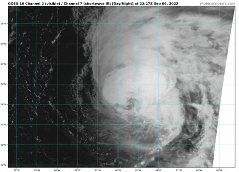
LOCATION...25.7N 65.7W
ABOUT 460 MI...740 KM S OF BERMUDA
MAXIMUM SUSTAINED WINDS...85 MPH...140 KM/H
PRESENT MOVEMENT...N OR 5 DEGREES AT 8 MPH...13 KM/H
MINIMUM CENTRAL PRESSURE...978 MB...28.88 INCHES


000
WTNT41 KNHC 071453
TCDAT1

Hurricane Earl Discussion Number 19
NWS National Hurricane Center Miami FL AL062022
1100 AM AST Wed Sep 07 2022

While it is evident that westerly vertical wind shear continues to
affect the overall satellite presentation of Earl, useful data
from the NOAA-P3 Hurricane Hunter aircraft indicates that the
hurricane is holding its own and has even strengthened a bit. Part
of this resilience could be due to the fact that the low and
mid-level centers of Earl are now vertically stacked with the wind
field relatively symmetric per the most recent set of Tail Doppler
Radar from the aircraft. However, the westerly shear is still
affecting the inner-core structure of the system, with its large 40
n mi wide eye open in the southern semicircle. The highest flight-
level winds from this morning's mission was 82 kt at 700 mb with
SFMR at 75 kt. The initial intensity was increased to 75 kt at the
8am intermediate advisory and remains this value for this advisory.

Fixes from this morning indicate that Earl has been moving just east
of due north, with the motion estimated at 005/6 kt. The hurricane
is caught in between a mid-level ridge now centered to its
southeast, with a positively-tilted upper-level trough located to
the northwest. This synoptic setup should enable Earl to begin
recurving north-northeastward and then northeastward as it
accelerates over the next 24-48 hours. The track guidance remains
tightly clustered during the early portion of the forecast, with the
GFS and ECMWF tracks now nearly identical during this period. The
official track forecast was only adjusted a touch east of the prior
one during this period. However, as noted previously, there is
increasing model support that the upper-level trough will ultimately
phase with Earl after 72 hours, resulting in the cyclone slowing
down significantly and potentially turning more northward in days
4-5. The official track forecast during this period now shows a bit
more of a northward bend and further slowdown compared to the prior
track, favoring a blend of the latest GFS and ECMWF forecast.

The persistent deep-layer westerly vertical wind shear that has been
impacting Earl the last several days is finally forecast to subside
later today, dropping below 10 kt in 24 hours. This decreasing
shear, in combination with very warm sea-surface temperatures,
favorable positioning in the right-entrance region of an upper-level
jet streak, and significant acceleration in the storm motion, is
likely to result in substantial strengthening of the surface wind
field and the latest NHC intensity forecast now shows a peak at 115
kt in 60-h, in good general agreement with the latest HCCA, yet
still under the LGEM intensity aid. After that, a significant
trough interaction is likely to rapidly increase baroclinicity, with
Earl forecast to become an extratropical-low as it phases with the
upper-level trough between days 3-4 in the forecast period.


KEY MESSAGES:

1. Although Earl's center is forecast to pass southeast of Bermuda,
the wind field is expected to grow, with tropical-storm-force winds
forecast to spread across the island beginning Thursday afternoon
and continuing through Friday morning.

2. Swells generated by Earl are expected to reach Bermuda by
tonight and the U.S. East Coast shortly thereafter. These swells
are likely to cause life-threatening surf and rip current
conditions through the weekend. Please consult products from your
local weather office.


FORECAST POSITIONS AND MAX WINDS

INIT 07/1500Z 25.7N 65.7W 75 KT 85 MPH
12H 08/0000Z 26.8N 65.6W 80 KT 90 MPH
24H 08/1200Z 28.5N 65.2W 90 KT 105 MPH
36H 09/0000Z 30.4N 64.1W 100 KT 115 MPH
48H 09/1200Z 33.0N 61.5W 110 KT 125 MPH
60H 10/0000Z 36.4N 57.3W 115 KT 130 MPH
72H 10/1200Z 40.1N 53.1W 100 KT 115 MPH
96H 11/1200Z 45.0N 49.0W 60 KT 70 MPH...POST-TROP/EXTRATROP
120H 12/1200Z 47.0N 47.9W 45 KT 50 MPH...POST-TROP/EXTRATROP

$$
Forecaster Papin
0 likes   

User avatar
ScottNAtlanta
Category 5
Category 5
Posts: 2367
Joined: Sat May 25, 2013 3:11 pm
Location: Atlanta, GA

Re: ATL: EARL - Hurricane - Discussion

#720 Postby ScottNAtlanta » Wed Sep 07, 2022 9:59 am

Shear is obviously reduced. Earl is much more round now than it has ever been
0 likes   
The posts in this forum are NOT official forecast and should not be used as such. They are just the opinion of the poster and may or may not be backed by sound meteorological data. They are NOT endorsed by any professional institution or storm2k.org. For official information, please refer to the NHC and NWS products.


Return to “2022”

Who is online

Users browsing this forum: No registered users and 15 guests