EPAC: KAY - Post-Tropical
Moderator: S2k Moderators
-
Sciencerocks
- Category 5

- Posts: 10181
- Age: 40
- Joined: Thu Jul 06, 2017 1:51 am
-
Sciencerocks
- Category 5
- Posts: 10181
- Age: 40
- Joined: Thu Jul 06, 2017 1:51 am
-
cycloneye

- Admin

- Posts: 149214
- Age: 69
- Joined: Thu Oct 10, 2002 10:54 am
- Location: San Juan, Puerto Rico
Re: EPAC: KAY - Tropical Storm
Tropical Storm Kay Discussion Number 22
NWS National Hurricane Center Miami FL EP122022
200 PM PDT Fri Sep 09 2022
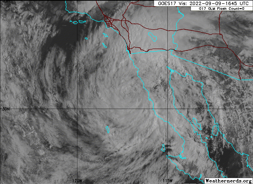
Reports from an Air Force Reserve Hurricane Hunter aircraft and
recent scatterometer data indicate that Kay continues to weaken,
with maximum winds of about 35 kt that are confined to an area over
the Pacific east and northeast of the center. Satellite imagery
shows no organized central convection, with the remaining
thunderstorms well to the north of the center over southern
California. The initial intensity is reduced to 35 kt based on the
aircraft and scatterometer data. However, stronger winds enhanced
by the mountainous terrain are occuring over portions of southern
California.
Unless the central convection re-develops, which appears unlikely
over sea surface temperatures of 21-22C, Kay should decay to a
remnant low tonight with the maximum winds decreasing below 35 kt.
The global models are in good agreement that the remnant low will
dissipate between 72-96 h, and the official forecast follows this.
While Kay is currently moving northwest or 305/10 kt, it is
starting its expected turn away from land and should move westward
at a slower forward speed during the next 12-24 h. After that, a
low-level ridge to the west of the remnant low should steer the
system slowly southward and southeastward until it dissipates.
There was again little change in the track forecast guidance since
the last advisory, and the new forecast track is similar to the
previous track.
Although Kay's intensity has decreased, wind, surf, and rainfall
impacts continue to extend far from the center so users should not
focus on the exact forecast track of Kay.
KEY MESSAGES:
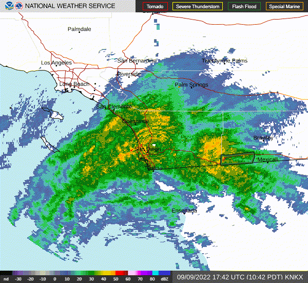
1. As the center of Kay passes just offshore, heavy rainfall will
likely result in flash flooding, including possible landslides,
across the Baja California peninsula and portions of mainland
northwestern Mexico through Saturday morning. Flash, urban, and
small stream flooding is likely across Southern California,
especially in and near the peninsular ranges, and also possible in
the Sierra Nevada, Arizona, and southern Nevada.
2. Tropical storm conditions are occurring over portions of the
Pacific coast of the Baja California peninsula, where a Tropical
Storm Warning is in effect.
3. Strong winds not directly associated with Kay's core wind field
are occurring across portions of southern California and extreme
southwestern Arizona. For information on this wind hazard, users
should see High Wind Warnings and other products from their local
NWS Weather Forecast Office.
FORECAST POSITIONS AND MAX WINDS
INIT 09/2100Z 31.0N 118.0W 35 KT 40 MPH
12H 10/0600Z 31.4N 119.1W 30 KT 35 MPH...POST-TROP/REMNT LOW
24H 10/1800Z 31.5N 120.3W 25 KT 30 MPH...POST-TROP/REMNT LOW
36H 11/0600Z 31.4N 121.2W 25 KT 30 MPH...POST-TROP/REMNT LOW
48H 11/1800Z 30.9N 121.9W 20 KT 25 MPH...POST-TROP/REMNT LOW
60H 12/0600Z 30.1N 121.8W 20 KT 25 MPH...POST-TROP/REMNT LOW
72H 12/1800Z 29.2N 121.4W 20 KT 25 MPH...POST-TROP/REMNT LOW
96H 13/1800Z...DISSIPATED
$$
Forecaster Beven
NWS National Hurricane Center Miami FL EP122022
200 PM PDT Fri Sep 09 2022
Reports from an Air Force Reserve Hurricane Hunter aircraft and
recent scatterometer data indicate that Kay continues to weaken,
with maximum winds of about 35 kt that are confined to an area over
the Pacific east and northeast of the center. Satellite imagery
shows no organized central convection, with the remaining
thunderstorms well to the north of the center over southern
California. The initial intensity is reduced to 35 kt based on the
aircraft and scatterometer data. However, stronger winds enhanced
by the mountainous terrain are occuring over portions of southern
California.
Unless the central convection re-develops, which appears unlikely
over sea surface temperatures of 21-22C, Kay should decay to a
remnant low tonight with the maximum winds decreasing below 35 kt.
The global models are in good agreement that the remnant low will
dissipate between 72-96 h, and the official forecast follows this.
While Kay is currently moving northwest or 305/10 kt, it is
starting its expected turn away from land and should move westward
at a slower forward speed during the next 12-24 h. After that, a
low-level ridge to the west of the remnant low should steer the
system slowly southward and southeastward until it dissipates.
There was again little change in the track forecast guidance since
the last advisory, and the new forecast track is similar to the
previous track.
Although Kay's intensity has decreased, wind, surf, and rainfall
impacts continue to extend far from the center so users should not
focus on the exact forecast track of Kay.
KEY MESSAGES:
1. As the center of Kay passes just offshore, heavy rainfall will
likely result in flash flooding, including possible landslides,
across the Baja California peninsula and portions of mainland
northwestern Mexico through Saturday morning. Flash, urban, and
small stream flooding is likely across Southern California,
especially in and near the peninsular ranges, and also possible in
the Sierra Nevada, Arizona, and southern Nevada.
2. Tropical storm conditions are occurring over portions of the
Pacific coast of the Baja California peninsula, where a Tropical
Storm Warning is in effect.
3. Strong winds not directly associated with Kay's core wind field
are occurring across portions of southern California and extreme
southwestern Arizona. For information on this wind hazard, users
should see High Wind Warnings and other products from their local
NWS Weather Forecast Office.
FORECAST POSITIONS AND MAX WINDS
INIT 09/2100Z 31.0N 118.0W 35 KT 40 MPH
12H 10/0600Z 31.4N 119.1W 30 KT 35 MPH...POST-TROP/REMNT LOW
24H 10/1800Z 31.5N 120.3W 25 KT 30 MPH...POST-TROP/REMNT LOW
36H 11/0600Z 31.4N 121.2W 25 KT 30 MPH...POST-TROP/REMNT LOW
48H 11/1800Z 30.9N 121.9W 20 KT 25 MPH...POST-TROP/REMNT LOW
60H 12/0600Z 30.1N 121.8W 20 KT 25 MPH...POST-TROP/REMNT LOW
72H 12/1800Z 29.2N 121.4W 20 KT 25 MPH...POST-TROP/REMNT LOW
96H 13/1800Z...DISSIPATED
$$
Forecaster Beven
0 likes
Visit the Caribbean-Central America Weather Thread where you can find at first post web cams,radars
and observations from Caribbean basin members Click Here
and observations from Caribbean basin members Click Here
-
Sciencerocks
- Category 5
- Posts: 10181
- Age: 40
- Joined: Thu Jul 06, 2017 1:51 am
-
cycloneye
- Admin
- Posts: 149214
- Age: 69
- Joined: Thu Oct 10, 2002 10:54 am
- Location: San Juan, Puerto Rico
Re: EPAC: KAY - Tropical Storm
1 likes
Visit the Caribbean-Central America Weather Thread where you can find at first post web cams,radars
and observations from Caribbean basin members Click Here
and observations from Caribbean basin members Click Here
-
Yellow Evan

- Professional-Met

- Posts: 16222
- Age: 27
- Joined: Fri Jul 15, 2011 12:48 pm
- Location: Henderson, Nevada/Honolulu, HI
- Contact:
Re: EPAC: KAY - Tropical Storm
Sciencerocks wrote:https://imagizer.imageshack.com/img923/9287/IZQ6nW.gif
When was the last time this happened?
Last TS to come at least this close to California was Nora in 1997.
4 likes
-
cycloneye
- Admin
- Posts: 149214
- Age: 69
- Joined: Thu Oct 10, 2002 10:54 am
- Location: San Juan, Puerto Rico
Re: EPAC: KAY - Tropical Storm
BULLETIN
Tropical Storm Kay Intermediate Advisory Number 22A
NWS National Hurricane Center Miami FL EP122022
500 PM PDT Fri Sep 09 2022
...KAY PULLING AWAY FROM THE NORTHERN BAJA CALIFORNIA PENINSULA...
...EXPECTED TO BECOME A POST-TROPICAL CYCLONE SOON...
SUMMARY OF 500 PM PDT...0000 UTC...INFORMATION
----------------------------------------------
LOCATION...31.2N 118.4W
ABOUT 130 MI...205 KM SSW OF SAN DIEGO CALIFORNIA
ABOUT 160 MI...260 KM WNW OF PUNTA BAJA MEXICO
MAXIMUM SUSTAINED WINDS...40 MPH...65 KM/H
PRESENT MOVEMENT...WNW OR 300 DEGREES AT 12 MPH...19 KM/H
MINIMUM CENTRAL PRESSURE...994 MB...29.36 INCHES
0 likes
Visit the Caribbean-Central America Weather Thread where you can find at first post web cams,radars
and observations from Caribbean basin members Click Here
and observations from Caribbean basin members Click Here
-
Sciencerocks
- Category 5
- Posts: 10181
- Age: 40
- Joined: Thu Jul 06, 2017 1:51 am
Re: EPAC: KAY - Tropical Storm
It is a shame that this couldn't have continued north as a tropical storm.
So close!
So close!
1 likes
-
cycloneye
- Admin
- Posts: 149214
- Age: 69
- Joined: Thu Oct 10, 2002 10:54 am
- Location: San Juan, Puerto Rico
Re: EPAC: KAY - Post-Tropical
Post-Tropical Cyclone Kay Discussion Number 23
NWS National Hurricane Center Miami FL EP122022
800 PM PDT Fri Sep 09 2022
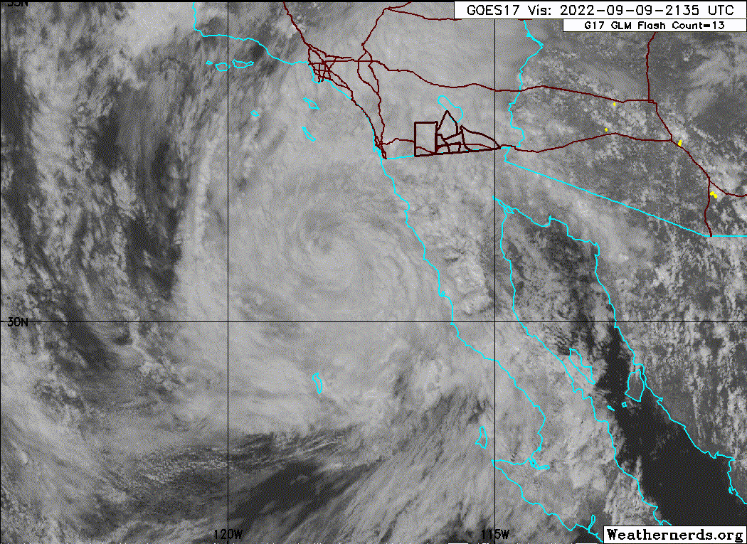
Kay has been devoid of deep convection just about all day (about the
past 15 hours), and it no longer meets the organized deep convection
criteria needed for a tropical cyclone. Therefore, Kay is now
considered a post-tropical cyclone, and since all coastal tropical
storm warnings have been discontinued, this is the last advisory on
this system. The initial intensity is held at 35 kt.
The low has now turned to the west-northwest, and a turn to the
southwest and then the south is expected this weekend and
early next week as the cyclone weakens while moving within the
low-level flow.
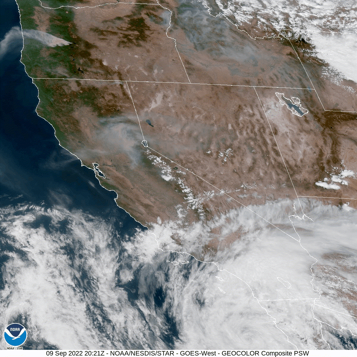
Even though Kay is no longer a tropical cyclone, this system is
still producing heavy rains across portions of northern Baja
California and southern California. In addition, strong winds not
directly associated with Kay's core wind field are still occurring
across portions of southern California and extreme southwestern
Arizona. For more information on the wind hazard, see products
from your local NWS Weather Forecast Office.
FORECAST POSITIONS AND MAX WINDS
INIT 10/0300Z 31.3N 118.9W 35 KT 40 MPH...POST-TROPICAL
12H 10/1200Z 31.4N 120.0W 30 KT 35 MPH...POST-TROP/REMNT LOW
24H 11/0000Z 31.4N 120.9W 25 KT 30 MPH...POST-TROP/REMNT LOW
36H 11/1200Z 31.2N 121.8W 25 KT 30 MPH...POST-TROP/REMNT LOW
48H 12/0000Z 30.5N 122.1W 20 KT 25 MPH...POST-TROP/REMNT LOW
60H 12/1200Z 29.6N 121.9W 20 KT 25 MPH...POST-TROP/REMNT LOW
72H 13/0000Z 29.0N 121.2W 20 KT 25 MPH...POST-TROP/REMNT LOW
96H 14/0000Z...DISSIPATED
$$
Forecaster Cangialosi
NWS National Hurricane Center Miami FL EP122022
800 PM PDT Fri Sep 09 2022
Kay has been devoid of deep convection just about all day (about the
past 15 hours), and it no longer meets the organized deep convection
criteria needed for a tropical cyclone. Therefore, Kay is now
considered a post-tropical cyclone, and since all coastal tropical
storm warnings have been discontinued, this is the last advisory on
this system. The initial intensity is held at 35 kt.
The low has now turned to the west-northwest, and a turn to the
southwest and then the south is expected this weekend and
early next week as the cyclone weakens while moving within the
low-level flow.
Even though Kay is no longer a tropical cyclone, this system is
still producing heavy rains across portions of northern Baja
California and southern California. In addition, strong winds not
directly associated with Kay's core wind field are still occurring
across portions of southern California and extreme southwestern
Arizona. For more information on the wind hazard, see products
from your local NWS Weather Forecast Office.
FORECAST POSITIONS AND MAX WINDS
INIT 10/0300Z 31.3N 118.9W 35 KT 40 MPH...POST-TROPICAL
12H 10/1200Z 31.4N 120.0W 30 KT 35 MPH...POST-TROP/REMNT LOW
24H 11/0000Z 31.4N 120.9W 25 KT 30 MPH...POST-TROP/REMNT LOW
36H 11/1200Z 31.2N 121.8W 25 KT 30 MPH...POST-TROP/REMNT LOW
48H 12/0000Z 30.5N 122.1W 20 KT 25 MPH...POST-TROP/REMNT LOW
60H 12/1200Z 29.6N 121.9W 20 KT 25 MPH...POST-TROP/REMNT LOW
72H 13/0000Z 29.0N 121.2W 20 KT 25 MPH...POST-TROP/REMNT LOW
96H 14/0000Z...DISSIPATED
$$
Forecaster Cangialosi
0 likes
Visit the Caribbean-Central America Weather Thread where you can find at first post web cams,radars
and observations from Caribbean basin members Click Here
and observations from Caribbean basin members Click Here
-
storm_in_a_teacup

- Category 1

- Posts: 496
- Age: 33
- Joined: Wed Aug 16, 2017 5:01 pm
- Location: Huntsville, Alabama (originally from Houston)
- Contact:
Re: EPAC: KAY - Post-Tropical
I just gotta say it was super awkward to leave Houston for LA at the height of hurricane season so I would miss it and then the hurricanes come to Southern California anyway.
Just the weather the past week in Southern California has been bizarre. I was in Orange County over the Labor Day Weekend and we straight up had a Severe Thunderstorm Warning in the middle of the heat wave, and then the storm actually hit. It was just so weird. Like summer thunderstorms and hurricanes are a thing in Houston...but in Los Angeles?...
Just the weather the past week in Southern California has been bizarre. I was in Orange County over the Labor Day Weekend and we straight up had a Severe Thunderstorm Warning in the middle of the heat wave, and then the storm actually hit. It was just so weird. Like summer thunderstorms and hurricanes are a thing in Houston...but in Los Angeles?...
1 likes
I know I can't straddle the atmosphere...just a tiny storm in your teacup, girl.
Who is online
Users browsing this forum: No registered users and 18 guests