ATL: FIONA - Models

Moderator: S2k Moderators

Message
Author
LarryWx
S2K Supporter
S2K Supporter
Posts: 6304
Joined: Sun Sep 07, 2003 2:04 pm
Location: GA

Re: ATL: SEVEN - Models

#181 Postby LarryWx » Thu Sep 15, 2022 7:35 am

caneman wrote:
toad strangler wrote:
caneman wrote:
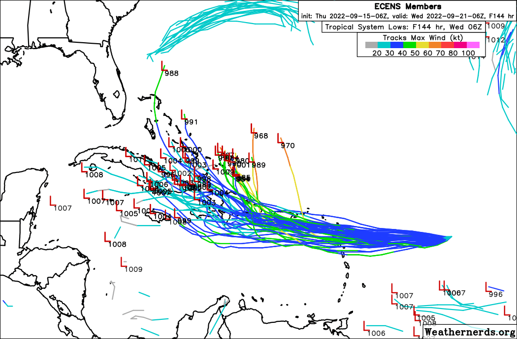
There is no safe call to make right now. It's too far out and some models have shifted West. Some taking it just South of the islands. Some keep it weaker and further West. There is no super highway OTS from just below the islands. And each storm and set up and timing is completely unique. I don't care if 90% of storms go out to sea. You don't know which will be the 10%.


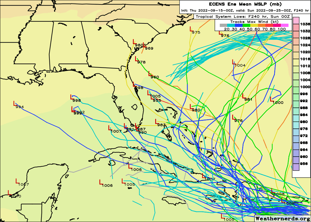
It's less than 10% and you changed the context of my post. I was speaking of the spot Fiona was at THAT moment. Not from underneath the GA's. There is absolutely a climatological re-curve favored track east of the CONUS from that genearl area I was talking about. I see the 6z GFS does just that. Although in rather interesting fashion. We shall see!


I didn't change the context, you can't make an assumption from that point as OTS and as a "safe call". You also cant weight post analysis with current analysis especially when current analysis showed there is still a wide model spread over a long range. Sure, do 90% or a larger portion in that area go OTS YES but you never know when the 10% of so won't. This may well be that one. We don't know yet and even more models this morning go further West now. I don't trust any modeling outside of 120 hours.


He was calling OTS the "safest" call as opposed to the "safe" call. Calling for a hit is certainly not a "safe" call either as that's a less safe call than calling for OTS based on historical tracks. He knows there's no "safe" call. He's saying the best odds by a good margin are OTS. Maybe better wording would be calling it "highest odds" rather than "safest".

Personally, I'm not at all even discounting the possibility of a move into the Gulf and I bet he'd say the same. I don't think the Gulf is even that low of a possibility.
Last edited by LarryWx on Thu Sep 15, 2022 7:39 am, edited 1 time in total.
3 likes   
Personal Forecast Disclaimer:
The posts in this forum are NOT official forecasts and should not be used as such. They are just the opinion of the poster and may or may not be backed by sound meteorological data. They are NOT endorsed by any professional institution or storm2k.org. For official information, please refer to the NHC and NWS products.

User avatar
skyline385
Category 5
Category 5
Posts: 2728
Age: 35
Joined: Wed Aug 26, 2020 11:15 pm
Location: Houston TX

Re: ATL: FIONA - Models

#182 Postby skyline385 » Thu Sep 15, 2022 7:38 am

12Z Early guidance, only a few models seem to suggest a westerly track so far but its 2022 so who knows :D

Image
0 likes   

User avatar
ronjon
Category 5
Category 5
Posts: 4822
Joined: Fri Aug 19, 2005 5:17 pm
Location: Hernando Beach, FL

Re: ATL: FIONA - Models

#183 Postby ronjon » Thu Sep 15, 2022 7:39 am

Seems like Hispanola is the wild card here and might make the model predictions more uncertain than they already are. If Fiona gets shredded and turns into a shallow weak low pressure, the chances will increase for an eventual GOM system. This would steer the system more W-NW in low level flow and generally faster forward motion which would miss the trough connection. On the flip side, if the system remains strong and avoids the shredder, a OTS solution is likely.
1 likes   

tolakram
Admin
Admin
Posts: 20009
Age: 62
Joined: Sun Aug 27, 2006 8:23 pm
Location: Florence, KY (name is Mark)

Re: ATL: FIONA - Models

#184 Postby tolakram » Thu Sep 15, 2022 7:39 am

HWRF still shows sudden organization and launch northwestward.

Image

Simulated radar makes no sense to me. Shear very low by 72 hours?

Image

200mb winds

Image

Could happen I suppose, but the word incompetent comes to mind here. And yes, it actually does reverse shear for a few hours. :roll:
0 likes   
M a r k
- - - - -
Join us in chat: Storm2K Chatroom Invite. Android and IOS apps also available.

The posts in this forum are NOT official forecasts and should not be used as such. Posts are NOT endorsed by any professional institution or STORM2K.org. For official information and forecasts, please refer to NHC and NWS products.

User avatar
Blown Away
S2K Supporter
S2K Supporter
Posts: 10145
Joined: Wed May 26, 2004 6:17 am

Re: ATL: FIONA - Models

#185 Postby Blown Away » Thu Sep 15, 2022 7:40 am

Image
00z ECENS... ATM the Euro seems to have the best handle on Fiona keeping her a shallow TD/TS and moving W instead of WNW.

8am had Fiona at 16.6N, the NHC 5pm yesterday had Fiona at @16.9 now. Not a huge difference, but for GA's it's not good and potentially more direct impact on Hispaniola. JMHO
3 likes   
Hurricane Eye Experience: David 79, Irene 99, Frances 04, Jeanne 04, Wilma 05... EYE COMING MY WAY IN 2024…
Hurricane Brush Experience: Andrew 92, Erin 95, Floyd 99, Matthew 16, Irma 17, Ian 22, Nicole 22…

tolakram
Admin
Admin
Posts: 20009
Age: 62
Joined: Sun Aug 27, 2006 8:23 pm
Location: Florence, KY (name is Mark)

Re: ATL: FIONA - Models

#186 Postby tolakram » Thu Sep 15, 2022 7:51 am

Image

Image
0 likes   
M a r k
- - - - -
Join us in chat: Storm2K Chatroom Invite. Android and IOS apps also available.

The posts in this forum are NOT official forecasts and should not be used as such. Posts are NOT endorsed by any professional institution or STORM2K.org. For official information and forecasts, please refer to NHC and NWS products.

User avatar
SFLcane
S2K Supporter
S2K Supporter
Posts: 10163
Age: 47
Joined: Sat Jun 05, 2010 1:44 pm
Location: Lake Worth Florida

Re: ATL: FIONA - Models

#187 Postby SFLcane » Thu Sep 15, 2022 7:54 am

2 likes   

tolakram
Admin
Admin
Posts: 20009
Age: 62
Joined: Sun Aug 27, 2006 8:23 pm
Location: Florence, KY (name is Mark)

Re: ATL: FIONA - Models

#188 Postby tolakram » Thu Sep 15, 2022 8:03 am

Euro showing less organized in the short term.

Image
1 likes   
M a r k
- - - - -
Join us in chat: Storm2K Chatroom Invite. Android and IOS apps also available.

The posts in this forum are NOT official forecasts and should not be used as such. Posts are NOT endorsed by any professional institution or STORM2K.org. For official information and forecasts, please refer to NHC and NWS products.

tolakram
Admin
Admin
Posts: 20009
Age: 62
Joined: Sun Aug 27, 2006 8:23 pm
Location: Florence, KY (name is Mark)

Re: ATL: FIONA - Models

#189 Postby tolakram » Thu Sep 15, 2022 8:04 am

Image
0 likes   
M a r k
- - - - -
Join us in chat: Storm2K Chatroom Invite. Android and IOS apps also available.

The posts in this forum are NOT official forecasts and should not be used as such. Posts are NOT endorsed by any professional institution or STORM2K.org. For official information and forecasts, please refer to NHC and NWS products.

User avatar
KWT
Category 5
Category 5
Posts: 31415
Joined: Tue Aug 17, 2004 11:02 am
Location: UK!!!

Re: ATL: FIONA - Models

#190 Postby KWT » Thu Sep 15, 2022 8:08 am

HWRF above seems to start with two lows that consolidate around a region closer to the convection, the main low then does small loops on a broadly westerly path. Certainly does some funky things on that run though for sure and I wonder if that is making it too far east vs other models which appear to keep things a little more straight forward.

For example 06z HWRF is at 62w on 18z Saturday, ECM is around 65-66W, which has huge differences for where the turn happens and whether it sails on out there unharmed, or whether it goes over the more mountainous islands instead as per the ECM.

All models do seem to agree though on a much more favourable set-up developing through Sunday, providing its not throttled itself overland too much.
1 likes   
Personal Forecast Disclaimer:
The posts in this forum are NOT official forecast and should not be used as such. They are just the opinion of the poster and may or may not be backed by sound meteorological data. They are NOT endorsed by any professional institution or storm2k.org. For official information, please refer to the NHC and NWS products

tolakram
Admin
Admin
Posts: 20009
Age: 62
Joined: Sun Aug 27, 2006 8:23 pm
Location: Florence, KY (name is Mark)

Re: ATL: FIONA - Models

#191 Postby tolakram » Thu Sep 15, 2022 8:17 am

Last from of 6Z run, moving NW into what appears to be a ridge. Not that I've ever been that good at reading model output.

Image
0 likes   
M a r k
- - - - -
Join us in chat: Storm2K Chatroom Invite. Android and IOS apps also available.

The posts in this forum are NOT official forecasts and should not be used as such. Posts are NOT endorsed by any professional institution or STORM2K.org. For official information and forecasts, please refer to NHC and NWS products.

User avatar
SFLcane
S2K Supporter
S2K Supporter
Posts: 10163
Age: 47
Joined: Sat Jun 05, 2010 1:44 pm
Location: Lake Worth Florida

Re: ATL: FIONA - Models

#192 Postby SFLcane » Thu Sep 15, 2022 8:28 am

EPS 06z

Image
2 likes   

User avatar
CFLHurricane
Category 1
Category 1
Posts: 346
Joined: Thu Mar 27, 2014 5:56 pm
Location: Floriduh

Re: ATL: FIONA - Models

#193 Postby CFLHurricane » Thu Sep 15, 2022 8:33 am

I don’t buy the sudden turn north next Tuesday the GFS, NAVGEM, and ICON are showing. I agree OTS is the likeliest outcome but the turn is just too tidy a solution.
0 likes   
I'm not a meteorologist, but I did stay at a motel 8.

User avatar
SFLcane
S2K Supporter
S2K Supporter
Posts: 10163
Age: 47
Joined: Sat Jun 05, 2010 1:44 pm
Location: Lake Worth Florida

Re: ATL: FIONA - Models

#194 Postby SFLcane » Thu Sep 15, 2022 8:49 am

06z EPS has a sw shift to a weaker solution so that was interesting.
1 likes   

AutoPenalti
Category 5
Category 5
Posts: 4030
Age: 29
Joined: Mon Aug 17, 2015 4:16 pm
Location: Ft. Lauderdale, Florida

Re: ATL: FIONA - Models

#195 Postby AutoPenalti » Thu Sep 15, 2022 8:57 am

SFLcane wrote:06z EPS has a sw shift to a weaker solution so that was interesting.

Likely modeling the exposed center that's going on right now.
1 likes   
The posts in this forum are NOT official forecasts and should not be used as such. They are just the opinion of the poster and may or may not be backed by sound meteorological data. They are NOT endorsed by any professional institution or STORM2K. For official information, please refer to products from the NHC and NWS.


Model Runs Cheat Sheet:
GFS (5:30 AM/PM, 11:30 AM/PM)
HWRF, GFDL, UKMET, NAVGEM (6:30-8:00 AM/PM, 12:30-2:00 AM/PM)
ECMWF (1:45 AM/PM)

TCVN
is a weighted averaged

LarryWx
S2K Supporter
S2K Supporter
Posts: 6304
Joined: Sun Sep 07, 2003 2:04 pm
Location: GA

Re: ATL: FIONA - Models

#196 Postby LarryWx » Thu Sep 15, 2022 9:09 am

SFLcane wrote:06z EPS has a sw shift to a weaker solution so that was interesting.


I expect more slow SW shifts of the mean track though probably not consistently from run to run.
1 likes   
Personal Forecast Disclaimer:
The posts in this forum are NOT official forecasts and should not be used as such. They are just the opinion of the poster and may or may not be backed by sound meteorological data. They are NOT endorsed by any professional institution or storm2k.org. For official information, please refer to the NHC and NWS products.

User avatar
SFLcane
S2K Supporter
S2K Supporter
Posts: 10163
Age: 47
Joined: Sat Jun 05, 2010 1:44 pm
Location: Lake Worth Florida

Re: ATL: FIONA - Models

#197 Postby SFLcane » Thu Sep 15, 2022 9:11 am

LarryWx wrote:
SFLcane wrote:06z EPS has a sw shift to a weaker solution so that was interesting.


I expect more slow SW shifts of the mean track though probably not consistently from run to run.


Indeed..
0 likes   

User avatar
SFLcane
S2K Supporter
S2K Supporter
Posts: 10163
Age: 47
Joined: Sat Jun 05, 2010 1:44 pm
Location: Lake Worth Florida

Re: ATL: FIONA - Models

#198 Postby SFLcane » Thu Sep 15, 2022 9:19 am

LarryWx wrote:
SFLcane wrote:06z EPS has a sw shift to a weaker solution so that was interesting.


I expect more slow SW shifts of the mean track though probably not consistently from run to run.


There seems to be a slow trend of eps members hooking westward towards florida even strong ones. Probably members where the CONUS ridge is allowed to build overhead

Image
3 likes   

User avatar
NDG
S2K Supporter
S2K Supporter
Posts: 15446
Joined: Sun Jul 09, 2006 10:14 pm
Location: Orlando, FL

Re: ATL: FIONA - Models

#199 Postby NDG » Thu Sep 15, 2022 9:54 am

Close up look of the 06z Euro run.

Image
1 likes   

AutoPenalti
Category 5
Category 5
Posts: 4030
Age: 29
Joined: Mon Aug 17, 2015 4:16 pm
Location: Ft. Lauderdale, Florida

Re: ATL: FIONA - Models

#200 Postby AutoPenalti » Thu Sep 15, 2022 10:01 am

NDG wrote:Close up look of the 06z Euro run.

https://i.imgur.com/GQOfH3v.gif

That has to be a center reformation on the Euro, there's no way it does an immediate sharp turn like that.
0 likes   
The posts in this forum are NOT official forecasts and should not be used as such. They are just the opinion of the poster and may or may not be backed by sound meteorological data. They are NOT endorsed by any professional institution or STORM2K. For official information, please refer to products from the NHC and NWS.


Model Runs Cheat Sheet:
GFS (5:30 AM/PM, 11:30 AM/PM)
HWRF, GFDL, UKMET, NAVGEM (6:30-8:00 AM/PM, 12:30-2:00 AM/PM)
ECMWF (1:45 AM/PM)

TCVN
is a weighted averaged


Return to “2022”

Who is online

Users browsing this forum: No registered users and 1 guest