ATL: FIONA - Post-Tropical - Discussion
Moderator: S2k Moderators


Re: ATL: FIONA - Hurricane - Discussion
Small pin-hole eye becoming increasingly evident. My take on it's immediate motion is nearly "nill". Combination of a bit weaker steering and further deepening (970's?). I think we will soon see a bit of a NW lurch within the next couple hours as a result of the much deeper west side convection rotating around to the south and then its east quad.
0 likes
Andy D
(For official information, please refer to the NHC and NWS products.)
(For official information, please refer to the NHC and NWS products.)
-
skyline385

- Category 5

- Posts: 2728
- Age: 35
- Joined: Wed Aug 26, 2020 11:15 pm
- Location: Houston TX

Re: ATL: FIONA - Hurricane - Discussion
Any low pressure wagers prior to D.R. landfall? I think i'll go with 972 mb.
0 likes
Andy D
(For official information, please refer to the NHC and NWS products.)
(For official information, please refer to the NHC and NWS products.)
Re: ATL: FIONA - Hurricane - Discussion
(Just once, i'd love to see the Bing bot or Google adsence bot chime in  )
)
4 likes
Andy D
(For official information, please refer to the NHC and NWS products.)
(For official information, please refer to the NHC and NWS products.)

Re: ATL: FIONA - Hurricane - Discussion
chaser1 wrote:Small pin-hole eye becoming increasingly evident. My take on it's immediate motion is nearly "nill". Combination of a bit weaker steering and further deepening (970's?). I think we will soon see a bit of a NW lurch within the next couple hours as a result of the much deeper west side convection rotating around to the south and then its east quad.
How long's the plane out there? This might've been the last pass until landfall.
0 likes
The above post is not official and should not be used as such. It is the opinion of the poster and may or may not be backed by sound meteorological data. It is not endorsed by any professional institution or storm2k.org. For official information, please refer to the NHC and NWS products.
-
cheezyWXguy

- Category 5
- Posts: 6282
- Joined: Mon Feb 13, 2006 12:29 am
- Location: Dallas, TX
Re: ATL: FIONA - Hurricane - Discussion
chaser1 wrote:Small pin-hole eye becoming increasingly evident. My take on it's immediate motion is nearly "nill". Combination of a bit weaker steering and further deepening (970's?). I think we will soon see a bit of a NW lurch within the next couple hours as a result of the much deeper west side convection rotating around to the south and then its east quad.
Not sure I agree on the pinhole eye, it looks to be about 15 miles wide on radar, but the rest I agree with. The last 45 min or so it looks entirely stationary to me. Wobble watching at its finest
1 likes
-
Hurricane Mike
- Category 2

- Posts: 675
- Joined: Tue Apr 10, 2018 7:44 am
Re: ATL: FIONA - Hurricane - Discussion
Video update on Hurricane Fiona for the night owls
https://www.youtube.com/watch?v=JiU3InWLHjI
https://www.youtube.com/watch?v=JiU3InWLHjI
0 likes

Re: ATL: FIONA - Hurricane - Discussion
Hammy wrote:chaser1 wrote:Small pin-hole eye becoming increasingly evident. My take on it's immediate motion is nearly "nill". Combination of a bit weaker steering and further deepening (970's?). I think we will soon see a bit of a NW lurch within the next couple hours as a result of the much deeper west side convection rotating around to the south and then its east quad.
How long's the plane out there? This might've been the last pass until landfall.
Looks like they’re getting ready for another pass. This will probably be their last of the mission.
1 likes
Irene '11 Sandy '12 Hermine '16 5/15/2018 Derecho Fay '20 Isaias '20 Elsa '21 Henri '21 Ida '21
I am only a meteorology enthusiast who knows a decent amount about tropical cyclones. Look to the professional mets, the NHC, or your local weather office for the best information.
I am only a meteorology enthusiast who knows a decent amount about tropical cyclones. Look to the professional mets, the NHC, or your local weather office for the best information.

Re: ATL: FIONA - Hurricane - Discussion
Eye clearing out?

2 likes
TC naming lists: retirements and intensity
Most aggressive Advisory #1's in North Atlantic (cr. kevin for starting the list)
Most aggressive Advisory #1's in North Atlantic (cr. kevin for starting the list)
-
Sciencerocks
- Category 5
- Posts: 10186
- Age: 40
- Joined: Thu Jul 06, 2017 1:51 am
Re: ATL: FIONA - Hurricane - Discussion

Even if it is going to turn northwestward I suspect that the DR will have a far larger impact on intensity then Puerto rico did and be inland probably for at least 12 hours.
2 likes


Re: ATL: FIONA - Hurricane - Discussion
chaser1 wrote:Any low pressure wagers prior to D.R. landfall? I think i'll go with 972 mb.
Santa Domingo 967== corner shot, off the backboard
Last edited by canebeard on Mon Sep 19, 2022 12:26 am, edited 1 time in total.
1 likes
List of 79 tropical cyclones intercepted by Richard Horodner:
http://www.canebeard.com/page/page/572246.htm
former storm2k screenname Beoumont 2009+
http://www.canebeard.com/page/page/572246.htm
former storm2k screenname Beoumont 2009+
-
Hurricane Mike
- Category 2
- Posts: 675
- Joined: Tue Apr 10, 2018 7:44 am
Re: ATL: FIONA - Hurricane - Discussion
I can't believe this is moving at 10 mph. It seems as though it's almost stationary.
1 likes
-
ElectricStorm

- Category 5
- Posts: 5147
- Age: 25
- Joined: Tue Aug 13, 2019 11:23 pm
- Location: Norman, OK
Re: ATL: FIONA - Hurricane - Discussion
Eye drop 980/8, supports 979-980, continues to gradually fall
0 likes
B.S Meteorology, University of Oklahoma '25
Please refer to the NHC, NWS, or SPC for official information.
Please refer to the NHC, NWS, or SPC for official information.
-
CrazyC83
- Professional-Met

- Posts: 34315
- Joined: Tue Mar 07, 2006 11:57 pm
- Location: Deep South, for the first time!
Re: ATL: FIONA - Hurricane - Discussion
With landfall farther south in the Dominican Republic, it could also throw off the future forecast. It will likely spend more time over land and have more time to weaken, especially if it interacts with the tall mountains. A weaker Fiona would likely go farther west for a while too.
0 likes
-
skyline385
- Category 5
- Posts: 2728
- Age: 35
- Joined: Wed Aug 26, 2020 11:15 pm
- Location: Houston TX
ATL: FIONA - Hurricane - Discussion
980mb on the last drop, looks like it has also completed its turn and will end up landfalling close to or south of Cap Cana


1 likes
-
ElectricStorm
- Category 5
- Posts: 5147
- Age: 25
- Joined: Tue Aug 13, 2019 11:23 pm
- Location: Norman, OK
Re: ATL: FIONA - Hurricane - Discussion
Hurricane Fiona Intermediate Advisory Number 19A
NWS National Hurricane Center Miami FL AL072022
200 AM AST Mon Sep 19 2022
...EYE OF FIONA APPROACHING THE COAST OF THE DOMINICAN REPUBLIC NEAR
PUNTA CANA...
...HEAVY RAINFALL AND CATASTROPHIC FLOODING CONTINUES ACROSS MUCH
OF PUERTO RICO...
SUMMARY OF 200 AM AST...0600 UTC...INFORMATION
----------------------------------------------
LOCATION...18.2N 68.4W
ABOUT 25 MI...40 KM S OF PUNTA CANA DOMINICAN REPUBLIC
MAXIMUM SUSTAINED WINDS...85 MPH...140 KM/H
PRESENT MOVEMENT...WNW OR 300 DEGREES AT 9 MPH...15 KM/H
MINIMUM CENTRAL PRESSURE...979 MB...28.91 INCHES
0 likes
B.S Meteorology, University of Oklahoma '25
Please refer to the NHC, NWS, or SPC for official information.
Please refer to the NHC, NWS, or SPC for official information.

Re: ATL: FIONA - Hurricane - Discussion
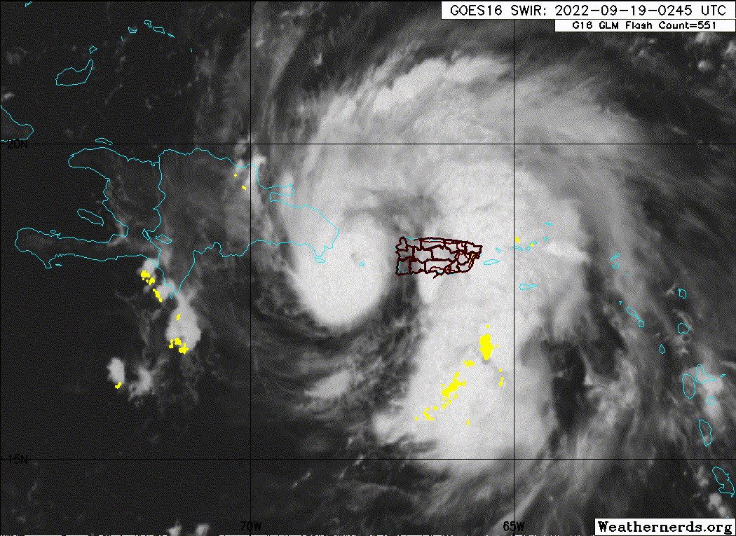
Man the amount of rain being dumped on PR is freaking absurd, I fear for what the daylight gonna bring.
0 likes
Personal Forecast Disclaimer:
The posts in this forum are NOT official forecast and should not be used as such. They are just the opinion of the poster and may or may not be backed by sound meteorological data. For official information, please refer to the NHC and NWS products.
The posts in this forum are NOT official forecast and should not be used as such. They are just the opinion of the poster and may or may not be backed by sound meteorological data. For official information, please refer to the NHC and NWS products.
-
skyline385
- Category 5
- Posts: 2728
- Age: 35
- Joined: Wed Aug 26, 2020 11:15 pm
- Location: Houston TX
Re: ATL: FIONA - Hurricane - Discussion
Josh already measuring 992mb on Punta Cana
https://twitter.com/icyclone/status/1571739365856124929
Sent from my iPhone using Tapatalk
https://twitter.com/icyclone/status/1571739365856124929
Sent from my iPhone using Tapatalk
1 likes
-
Sciencerocks
- Category 5
- Posts: 10186
- Age: 40
- Joined: Thu Jul 06, 2017 1:51 am
Who is online
Users browsing this forum: No registered users and 15 guests