

ATL: FIONA - Post-Tropical - Discussion
Moderator: S2k Moderators
Re: ATL: FIONA - Hurricane - Discussion
Talk about last minute improvement. Fortunate this is close to landfall, but DR is in for a ride.
5 likes


Re: ATL: FIONA - Hurricane - Discussion
CrazyC83 wrote:With landfall farther south in the Dominican Republic, it could also throw off the future forecast. It will likely spend more time over land and have more time to weaken, especially if it interacts with the tall mountains. A weaker Fiona would likely go farther west for a while too.
I was contemplating the same thing but hadnt taken the time today to look and see whether lower level steering forecasts were significantly westward or also soon phasing into the overall deep layer. Days ago I had thought that combination of landfall weakening and low level steering could have been the catalyst to potentially see Fiona threaten Cuba, Western Bahamas, or Florida.
0 likes
Andy D
(For official information, please refer to the NHC and NWS products.)
(For official information, please refer to the NHC and NWS products.)
Re: ATL: FIONA - Hurricane - Discussion
Landy wrote:Talk about last minute improvement. Fortunate this is close to landfall, but DR is in for a ride.
https://cdn.discordapp.com/attachments/1019702388719890443/1021301677296472094/9394d174-9f2e-485c-b0c4-e0cb231cc115.jpeg
Hmm? Latest pics suggest that Canebeard's 967 mb bank-shot off the back-board ain't looking that unreasonable
1 likes
Andy D
(For official information, please refer to the NHC and NWS products.)
(For official information, please refer to the NHC and NWS products.)
-
weeniepatrol

- Category 5

- Posts: 1343
- Joined: Sat Aug 22, 2020 5:30 pm
- Location: WA State
-
weeniepatrol
- Category 5
- Posts: 1343
- Joined: Sat Aug 22, 2020 5:30 pm
- Location: WA State

-
weeniepatrol
- Category 5
- Posts: 1343
- Joined: Sat Aug 22, 2020 5:30 pm
- Location: WA State
-
REDHurricane

- Category 1

- Posts: 438
- Age: 28
- Joined: Sun Jul 03, 2022 2:36 pm
- Location: Northeast Pacific Ocean
Re: ATL: FIONA - Hurricane - Discussion
Anyone know why another vorticity center appears to be forming right next to Fiona?

2 likes
-
ElectricStorm

- Category 5
- Posts: 5147
- Age: 25
- Joined: Tue Aug 13, 2019 11:23 pm
- Location: Norman, OK
Re: ATL: FIONA - Hurricane - Discussion

UW - CIMSS
ADVANCED DVORAK TECHNIQUE
ADT-Version 9.0
Tropical Cyclone Intensity Algorithm
----- Current Analysis -----
Date : 19 SEP 2022 Time : 055020 UTC
Lat : 18:12:35 N Lon : 68:17:24 W
CI# /Pressure/ Vmax
4.7 / 971mb / 82kts
Final T# Adj T# Raw T#
4.7 4.7 5.8
ADVANCED DVORAK TECHNIQUE
ADT-Version 9.0
Tropical Cyclone Intensity Algorithm
----- Current Analysis -----
Date : 19 SEP 2022 Time : 055020 UTC
Lat : 18:12:35 N Lon : 68:17:24 W
CI# /Pressure/ Vmax
4.7 / 971mb / 82kts
Final T# Adj T# Raw T#
4.7 4.7 5.8
0 likes
B.S Meteorology, University of Oklahoma '25
Please refer to the NHC, NWS, or SPC for official information.
Please refer to the NHC, NWS, or SPC for official information.
-
ElectricStorm
- Category 5
- Posts: 5147
- Age: 25
- Joined: Tue Aug 13, 2019 11:23 pm
- Location: Norman, OK
Re: ATL: FIONA - Hurricane - Discussion
1 likes
B.S Meteorology, University of Oklahoma '25
Please refer to the NHC, NWS, or SPC for official information.
Please refer to the NHC, NWS, or SPC for official information.
-
Sciencerocks
- Category 5
- Posts: 10186
- Age: 40
- Joined: Thu Jul 06, 2017 1:51 am
Re: ATL: FIONA - Hurricane - Discussion
At least 12 hours over the shedder!!! Probably a tropical storm at exit.
5 likes
-
ElectricStorm
- Category 5
- Posts: 5147
- Age: 25
- Joined: Tue Aug 13, 2019 11:23 pm
- Location: Norman, OK
Re: ATL: FIONA - Hurricane - Discussion
07L FIONA 220919 0600 18.2N 68.4W ATL 80 977
0 likes
B.S Meteorology, University of Oklahoma '25
Please refer to the NHC, NWS, or SPC for official information.
Please refer to the NHC, NWS, or SPC for official information.

Re: ATL: FIONA - Hurricane - Discussion
REDHurricane wrote:Anyone know why another vorticity center appears to be forming right next to Fiona?
https://gcdnb.pbrd.co/images/wjIGSYduf7td.gif?o=1
Pretty common with these islands, it's basically orographic. Puerto Rico also has some natural pressure lowering/vorticity that likely contributed to Fiona's 'loop'

5 likes
The above post is not official and should not be used as such. It is the opinion of the poster and may or may not be backed by sound meteorological data. It is not endorsed by any professional institution or storm2k.org. For official information, please refer to the NHC and NWS products.
Re: ATL: FIONA - Hurricane - Discussion
Hurricane Fiona Tropical Cyclone Update
NWS National Hurricane Center Miami FL AL072022
335 AM AST Mon Sep 19 2022
...FIONA MAKES LANDFALL IN THE DOMINICAN REPUBLIC...
NWS Doppler radar data indicate that the eye of Hurricane Fiona has
made landfall along the coast of the Dominican Republic near Boca de
Yuma at 330 AM AST...0730 UTC. Maximum sustained winds at landfall
were estimated to be 90 mph (150 km/h). The Punta Cana International
Airport recently reported a sustained wind of 51 mph (81 km/h) and a
gust of 79 mph (128 km/h).
SUMMARY OF 330 AM AST...0730 UTC...INFORMATION
----------------------------------------------
LOCATION...18.4N 68.5W
ABOUT 15 MI...25 KM SSW OF PUNTA CANA DOMINICAN REPUBLIC
MAXIMUM SUSTAINED WINDS...90 MPH...150 KM/H
PRESENT MOVEMENT...NW OR 305 DEGREES AT 8 MPH...13 KM/H
MINIMUM CENTRAL PRESSURE...977 MB...28.85 INCHES
$$
Forecaster Reinhart/Papin
1 likes

-
Sciencerocks
- Category 5
- Posts: 10186
- Age: 40
- Joined: Thu Jul 06, 2017 1:51 am

Re: ATL: FIONA - Hurricane - Discussion
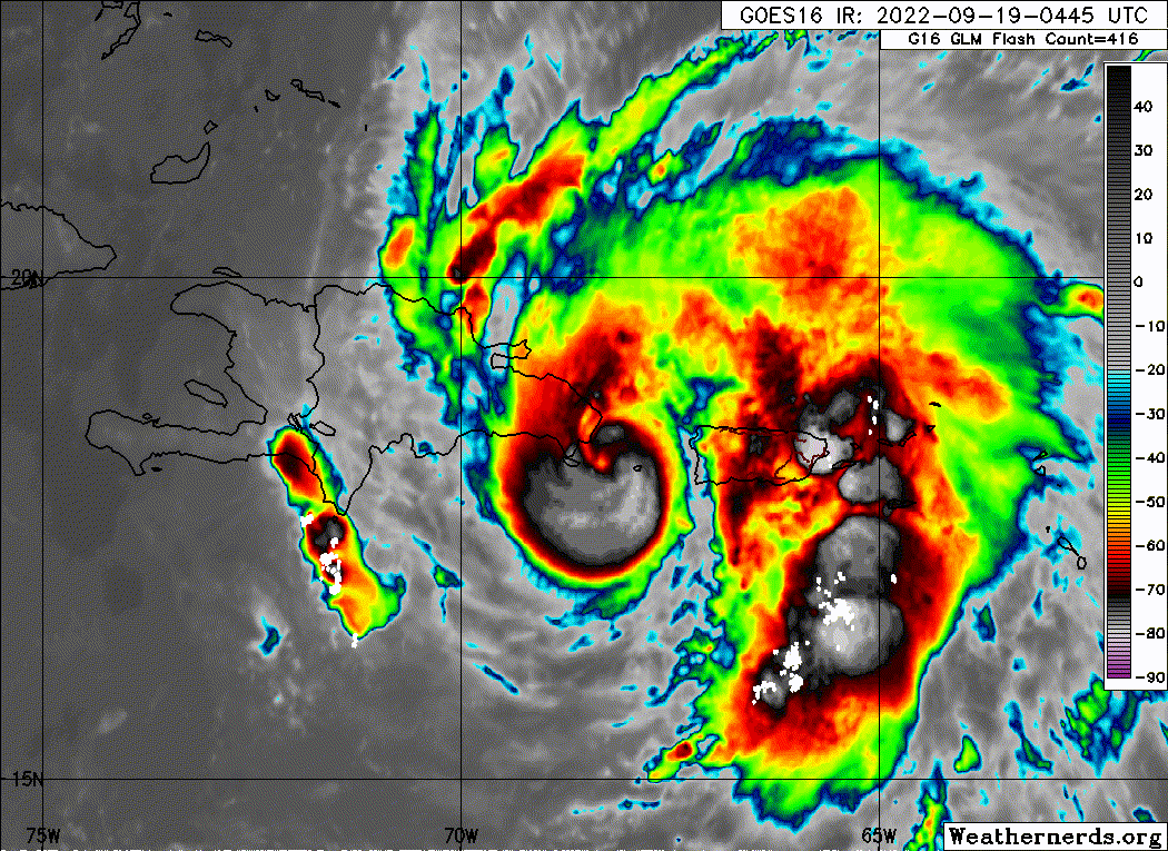
Since Fiona has made a second landfall I think it's important to note that Hispaniola's east side is quite flat. While being above land will weaken Fiona, I don't think it will have the 'shredder' effect that we're used to when something goes over the island east to west.

9 likes
Re: ATL: FIONA - Hurricane - Discussion
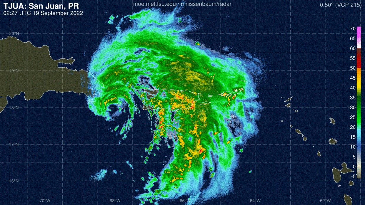
Latest Fiona IR loop. The eye is still holding on and Fiona is a lot further west than forecast, almost reaching the edge of yesterday's cone.
3 likes

Re: ATL: FIONA - Hurricane - Discussion
It will likely track back out over the water near Las Terrenas without being shredded by the mountains, not sure about the Bermuda forecast yet.
0 likes
-
weeniepatrol
- Category 5
- Posts: 1343
- Joined: Sat Aug 22, 2020 5:30 pm
- Location: WA State

Re: ATL: FIONA - Hurricane - Discussion
The eye is still looking good despite being over land for two hours. It’s already halfway to the coast and should be back over water in another two hours, possibly in time to be intercepted by the recon plane that just took off.
3 likes
Irene '11 Sandy '12 Hermine '16 5/15/2018 Derecho Fay '20 Isaias '20 Elsa '21 Henri '21 Ida '21
I am only a meteorology enthusiast who knows a decent amount about tropical cyclones. Look to the professional mets, the NHC, or your local weather office for the best information.
I am only a meteorology enthusiast who knows a decent amount about tropical cyclones. Look to the professional mets, the NHC, or your local weather office for the best information.
Who is online
Users browsing this forum: No registered users and 20 guests